| Previous :: Next Topic |
| Author |
Message |
H. Hound
Member


Joined: 09 May 2003
Posts: 1205 | TRs | Pics
Location: Exit 32 |
|
H. Hound
Member
|
 Sun Jun 01, 2003 6:30 pm |
|
|
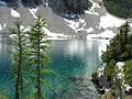
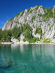
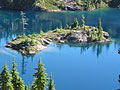
Snow Lake Via Middle Fork Snoqualmie Dingford Creek Trailhead.
This is one of my favorite early season hikes. I rarely see anybody on this trail. The last ½ mile of trail is solid snow from about the second to last Talus field crossing on. The lake basin is still full, and the lake is still frozen/shushed over.
Good news The Middle Fork road was re-graded up to the Taylor River about 3 weeks ago. So, the only bad road is the last 6 miles (just as ugly as ever).
The Middle Fork trail is in good shape, and free of blow downs. Once you leave the Middle Fork trail and start up and into Snow Lake (rock creek trail?), the trail stays in fair shape. It is a seldom-used trail that can be rocky, covered with moss, and other plants in places. Somebody brushed the 3 really bad switchbacks last year, and removed the blow dawns (thank you). New for this year are more blow downs. There are 3 fairly near each other at roughly the 5 to 6 mile mark, and one small one at about 4 miles. None are hard to get around.
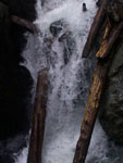
Attached are some pics. The picture of the falls doesn't do them justice.
Happy trails - KN
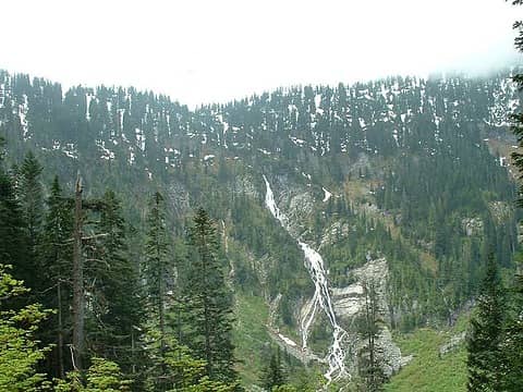 SnowLkFalls 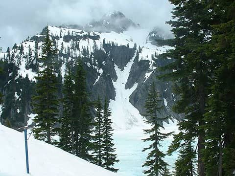 SnowLk
|
| Back to top |
  
|
|
Backpacker Joe
Blind Hiker

Joined: 16 Dec 2001
Posts: 23956 | TRs | Pics
Location: Cle Elum |
Nice report, thanks!
TB
"If destruction be our lot we must ourselves be its author and finisher. As a nation of freemen we must live through all time or die by suicide."
Abraham Lincoln
"If destruction be our lot we must ourselves be its author and finisher. As a nation of freemen we must live through all time or die by suicide."
Abraham Lincoln
|
| Back to top |
|
|
polarbear-
Guest

|
|
polarbear-
Guest
|
Sun Jun 01, 2003 8:49 pm |
|
|
I've only been to Snow Lake via the main trail. The falls area looks neat. Where does the trail go in relation to the falls?
|
| Back to top |

|
|
H. Hound
Member
Joined: 09 May 2003
Posts: 1205 | TRs | Pics
Location: Exit 32 |
|
H. Hound
Member
|
Sun Jun 01, 2003 9:13 pm |
|
|
The falls are on the other side of the canyon (not close). They are created by the outlet of Snow lake. According to Mr. GPS it is 7.24 miles to the lake. Of course Mr. GPS also said it was 5.2 miles out (got love those signal drops).
Bye - KN
|
| Back to top |
|
|
Sore Feet
Member

Joined: 16 Dec 2001
Posts: 6307 | TRs | Pics
Location: Out There, Somewhere |
| polarbear- wrote: | | I've only been to Snow Lake via the main trail. The falls area looks neat. Where does the trail go in relation to the falls? |
Yeah, that one is high up on my want list too. I just need someone to get me up the middle fork road....*glances towards BPJ*  By my estimates from the topo maps, that's a few feet shy of a 1200 foot waterfall there.
|
| Back to top |
|
|
tasslehouf
Member
Joined: 27 Mar 2003
Posts: 29 | TRs | Pics
Location: Lynnwood |
Beautiful shots
That's now on my list of must hikes
|
| Back to top |
|
|
sarbar
Living The Dream
Joined: 28 Jan 2002
Posts: 8055 | TRs | Pics
Location: Freeland, Wa |
|
sarbar
Living The Dream
|
Mon Jun 02, 2003 7:23 am |
|
|
|
| Back to top |
|
|
Tom
Admin
Joined: 15 Dec 2001
Posts: 17854 | TRs | Pics
|
|
Tom
Admin
|
Tue Apr 27, 2004 5:43 pm |
|
|
Decided to check out Rock Creek on Sunday. Trail is snow free up to about 3200'. Was able to make it to about 3400', beyond which travel was unsafe due to precarious snow bridges covering a very steep section of the trail. Ran into the elusive H. Hound on the way up.
|
| Back to top |
|
|
H. Hound
Member
Joined: 09 May 2003
Posts: 1205 | TRs | Pics
Location: Exit 32 |
|
H. Hound
Member
|
Tue Apr 27, 2004 7:41 pm |
|
|
I thought you were going up there Saturday? Oh well it was nice meeting you. You must have gone up the snow covered switchbacks. After them is where the trail crosses a ravine, and is blasted in to the side of a cliff band. If that section had been snow free I would have gone for it. Instead I turned back at the first snow covered switch back (didnt see any point to kick stepping up a few switch backs just to turn around).
The trail mostly follows the band of snow in the attached pic.
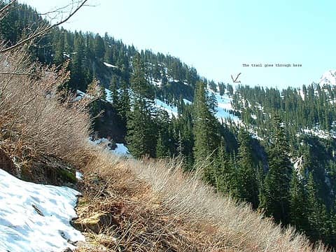 Rock Crk
|
| Back to top |
|
|
polarbear
Member

Joined: 16 Dec 2001
Posts: 3680 | TRs | Pics
Location: Snow Lake hide-away |
So is the lake below the arrow, or is that just a false summit.
|
| Back to top |
|
|
H. Hound
Member
Joined: 09 May 2003
Posts: 1205 | TRs | Pics
Location: Exit 32 |
|
H. Hound
Member
|
Tue Apr 27, 2004 8:02 pm |
|
|
The arrow is pointing at this little pass (I think). The snow covered lake is in the background.
 Pass
|
| Back to top |
|
|
Tom
Admin
Joined: 15 Dec 2001
Posts: 17854 | TRs | Pics
|
|
Tom
Admin
|
Tue Apr 27, 2004 10:18 pm |
|
|
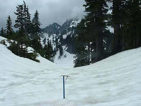
Yep, basically made it to the ravine and figured I'd call it a day.  A few more pics.
|
| Back to top |
|
|
Far Fig Newton
Member
Joined: 24 Jan 2004
Posts: 57 | TRs | Pics
|
Ye old Cascade Crest (Pacific Crest) trail, before the 1970's revision to the Kendell Katwalk.
|
| Back to top |
|
|
Backpacker Joe
Blind Hiker
Joined: 16 Dec 2001
Posts: 23956 | TRs | Pics
Location: Cle Elum |
Hey, how'd ya do on the road Thomas?
How far do you figure you hiked?
TB
"If destruction be our lot we must ourselves be its author and finisher. As a nation of freemen we must live through all time or die by suicide."
Abraham Lincoln
"If destruction be our lot we must ourselves be its author and finisher. As a nation of freemen we must live through all time or die by suicide."
Abraham Lincoln
|
| Back to top |
|
|
Tom
Admin
Joined: 15 Dec 2001
Posts: 17854 | TRs | Pics
|
|
Tom
Admin
|
Wed Apr 28, 2004 8:24 am |
|
|
The road to Taylor has more than the usual number of potholes. Beyond Taylor it's standard MFK fare.
|
| Back to top |
|
|
|
|


