| Previous :: Next Topic |
| Author |
Message |
Tibbdoo
Guest

|
|
Tibbdoo
Guest
|
 Mon Jun 02, 2003 8:08 am |
|
|
Hiked Saturday AM to Mineral City and slightly beyond toward Poodle Dog Pass. What a varied and beautiful hike. Trail is in great shape and appears as if someone or group is maintaining and improving it. At one point small alders edged the trail - quite odd- as it is in an area where the trail is clearly defined - and here and there you can see stacks of small square rocks... space aliens????
The area of the old town is essentially a rocky river bed [definitely more like a river in use during our visit] and is passable if you don't mind searching a path and getting your feet wet.
Thanks to all who have posted on this hike - it gave me a great deal of info about the hike and area.
|
| Back to top |
  
|
 |
MooseAndSquirrel
Member
Joined: 10 Nov 2002
Posts: 2036 | TRs | Pics
|
Hey Tibbdoo, just after the Mineral City site there is a stream coming down from the left that flows into Silver Creek- that's as far as I've gotten up the road/trail towards Poodle Dog Pass. The water was running too high and there weren't any decent spots to rock-hop over(This was a few years ago around this time). You can see the road continue on over on the other side. If this sounds right how does it look for getting across now? Thanks, M&S
|
| Back to top |

|
|
Newt
Short Timer
Joined: 21 Dec 2001
Posts: 3176 | TRs | Pics
Location: Down the road and around the corner |
|
Newt
Short Timer
|
Mon Jun 02, 2003 7:19 pm |
|
|
Yes sirre bob. I be interested too.
When I was there in late June 02 the creek was still pretty high. Would liked to have crossed but looked a little too risky for this cowboy at the time.
There had been lots of trail work up to that point and appeared to continue on the other side. In fact, just before the clearing there were tents pitched with no one in sight. Trial workers? Mine explorers?
NN
 Creek Crossing
It's pretty safe to say that if we take all of man kinds accumulated knowledge, we still don't know everything. So, I hope you understand why I don't believe you know everything. But then again, maybe you do.
It's pretty safe to say that if we take all of man kinds accumulated knowledge, we still don't know everything. So, I hope you understand why I don't believe you know everything. But then again, maybe you do.
|
| Back to top |
|
|
Sawyer
Guest
|
|
Sawyer
Guest
|
Mon Jun 02, 2003 9:46 pm |
|
|
The ancient and venerable route to Poodle Dog Pass is in decent shape as of about 3 years ago. There is only one confusing section. And it's not easy to find from Poodledog Pass if you haven't found it.
The even more ancient trail didn't go to Poodledog Pass though -- it went on a rising traverse to Pearsall Pass, thence down 76 Basin to Monte Cristo. I've not found any trace of that 100 year old route though.
|
| Back to top |
|
|
Newt
Short Timer
Joined: 21 Dec 2001
Posts: 3176 | TRs | Pics
Location: Down the road and around the corner |
|
Newt
Short Timer
|
Tue Jun 03, 2003 4:47 am |
|
|
| Sawyer wrote: | | The ancient and venerable route to Poodle Dog Pass is in decent shape as of about 3 years ago. There is only one confusing section. And it's not easy to find from Poodledog Pass if you haven't found it.
The even more ancient trail didn't go to Poodledog Pass though -- it went on a rising traverse to Pearsall Pass, thence down 76 Basin to Monte Cristo. I've not found any trace of that 100 year old route though. |
Did you make it all the way from Mineral City to Monte Cristo? How long did it take?
Thanks,
NN
It's pretty safe to say that if we take all of man kinds accumulated knowledge, we still don't know everything. So, I hope you understand why I don't believe you know everything. But then again, maybe you do.
It's pretty safe to say that if we take all of man kinds accumulated knowledge, we still don't know everything. So, I hope you understand why I don't believe you know everything. But then again, maybe you do.
|
| Back to top |
|
|
Sawyer
Guest
|
|
Sawyer
Guest
|
Tue Jun 03, 2003 6:07 am |
|
|
I've hiked from Galena to Poodledog Pass, and back, in a longish day. It's about 15 mi round trip. The road bed above Mineral City is tedious with its large rocks for several miles. Lots to see en route (ref: Discovering Washington's Historic Mines by Oso Press, Monte Cristo Area by Majors & McClollum, Monte Cristo by Woodhouse) so it's hard to rush the trip.
I've also "hiked" the route from Monte Cristo to Pearsall Pass via 76 Basin. Lost the trail completely and scrambled up the very steep hillside.
|
| Back to top |
|
|
Tibbdoo
Guest
|
|
Tibbdoo
Guest
|
Tue Jun 03, 2003 7:17 am |
|
|
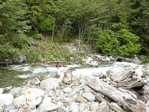
We were able to cross on Saturday. Someone had placed several large boulders and logs in the water and we were able to scramble over. The trail continues and is in great shape. A camping area with a fire pit is beyond this crossing and before the next bridge.
Funny - We ran into a group of 5 that were attempting to 'wade' through the town, and they asked "How much farther to Mineral City?" It was hard to tell them they were already there!
|
| Back to top |
|
|
MooseAndSquirrel
Member
Joined: 10 Nov 2002
Posts: 2036 | TRs | Pics
|
Tibbdoo, thanks for the info and pic. I definitely want to go further on across that side creek up valley someday. I just didn't have the nerve at the time (and I was solo) to try to pick my way across. When I was up at Mineral City in a June 3-4 yrs ago the old town site was high and dry-no water on the trail at all. Sheesh, I've gotta do Poodle Dog Pass/Silver Lk.(from Monte Cristo) for cryin' out loud- I've never done it yet.
|
| Back to top |
|
|
Newt
Short Timer
Joined: 21 Dec 2001
Posts: 3176 | TRs | Pics
Location: Down the road and around the corner |
|
Newt
Short Timer
|
Tue Jun 03, 2003 6:40 pm |
|
|
That's something I've wanted to do for a some time. End to end.
Many, many years ago I had been way up Monte Cristo and also up the Mineral City side. Never got close to doin the whole thing.
Do you think a gps would help in the area of losing the trail? I know they aren't 100% but could keep you close to it. How about a fly over in a plane?
'Tis sumptin I'm gonna think about.
NN
It's pretty safe to say that if we take all of man kinds accumulated knowledge, we still don't know everything. So, I hope you understand why I don't believe you know everything. But then again, maybe you do.
It's pretty safe to say that if we take all of man kinds accumulated knowledge, we still don't know everything. So, I hope you understand why I don't believe you know everything. But then again, maybe you do.
|
| Back to top |
|
|
Pin Toe
Hiking Did That 2 Me

Joined: 29 Sep 2003
Posts: 55 | TRs | Pics
|
|
Pin Toe
Hiking Did That 2 Me
|
Mon Sep 29, 2003 12:47 pm Bears?
|
|
|
We're taking a small group up there next month. Want to hike as far as Mineral City and camp, then attempt Poodle Dog pass the next day as a day hike. Any tips? Has anyone camped in this area? Has anyone had any problems with bears? The Skykomish Ranger Station told me today it is a bear area and they recommend canistering all food.
|
| Back to top |
|
|
Dogpatch
Member

Joined: 17 Aug 2003
Posts: 1588 | TRs | Pics
Location: the dryside |
|
Dogpatch
Member
|
Mon Sep 29, 2003 2:28 pm |
|
|
We got up as far as Molybdenum Gulch two months ago--could see Poodle Dog, but it would have been an overnight for us, at our pace, and we hadn't planned on it, darn!
If you go past Mineral City, there's a pretty little camp spot close to the bridge over Silver Creek.
We ran into one other person the whole day. He said he had flagged the route to Poodle Dog, so that might be a help, if the flags are still up. This is one of those trails that's going to disappear if people don't use it.
Good luck!
"Outside of a dog, a book is man's best friend.
Inside of a dog, it's too dark to read." Groucho Marx
"Outside of a dog, a book is man's best friend.
Inside of a dog, it's too dark to read." Groucho Marx
|
| Back to top |
|
|
Gordy Comer
Member
Joined: 18 Dec 2002
Posts: 46 | TRs | Pics
|
Sam and I camped at Moly Gulch on July 19th. We visited the Mountain Queen Mine as the sun went down. This is about a mile and a half past Mineral City. You can see the Bonanza cabin from just a couple spots, still looks great. We visited Minnehaha Falls on the way to Silver lake the next day, then hiked out. The route wasn't too hard, plenty of brush to wack, sometimes a ribbon. The trail the last 1/4 mile to the lake had been brushed out. I am limiting my description of the route to encourage everyone to figure things out as we did. If you go, how about carrying a pair of clippers, clean up the trail a bit.
|
| Back to top |
|
|
cheakamus
Member
Joined: 19 Jul 2003
Posts: 331 | TRs | Pics
Location: Seattle |
|
cheakamus
Member
|
Sat Oct 04, 2003 10:51 pm Galena-Silver Lake daytrip
|
|
|
What a glorious day! I left Seattle this morning at 7:10 in thick fog. By 8:30 I was on the trail. The fog lifted two miles before Index, and thereafter, the sun shone all day with nary a cloud in the sky.
Fearing damage to my oil pan, I parked close to the bottom of the road, which added an extra mile and perhaps 20 minutes to the hike (each way). However, anyone with a truck with high clearance should have no trouble driving to the trailhead.
There were half a dozen people at the trailhead (just before the giant rockslide that blocks the road) when I arrived. They were apparently there to look at a mine for sale (the Nugget Chief, located up a spur road to the left from the trailhead).
Some spectacular views of Silver Creek from the road/trail. The section before Mineral City reminds me of the road to Monte Cristo. I made pretty good time, arriving at the Mineral City site after about one hour. No problem crossing the creek--I simply stepped across the foot-wide channel!
After Mineral City, the trail crosses Silver Creek on an old logging bridge and continues up the valley on the south side of the creek. About halfway up, it crosses over to the north side, traverses a clearcut (now quickly growing in with small firs and cedars), crosses Silver Creek again, then turns northward and climbs steeply to Poodle Dog Pass and Silver Lake. HOWEVER ...
It's easy to lose the trail in places, and much of it is grown in, requiring pushing through brush (mostly huckleberries and alder). Luckily, today the brush was perfectly dry--in wet weather or heavy dew, you'd want a pair of rainpants, as well as a jacket.
My only serious mistake was in not consulting my USGS map more closely. I missed the first creek crossing after Mineral City and headed uphill on the wrong side of the creek for about a hundred feet or so. (However, I did discover some matsutaki mushrooms along the way). After that, I never went more than 10 or 15 feet off trail without stopping and looking around for the orange flags that decorate the last half of the trail.
To Silver Lake took about 4 hours, and three-quarters of the time was spent on less than half of the distance. As others have mentioned, there has been some attempt made at clearing the brush along segments of the trail. Elsewhere, it is growing in faster than the limited amount of traffic can compete with. It would really be a shame if this beautiful and historic trail were lost.
I had a quick swim in Silver Lake and a wander partway down the other side of Poodle Dog Pass before turning around to head back to Galena. It took me three and a half hours to reach my car, again with the brush along the upper half of the trail slowing me down considerably.
My advise to other hikers: get a USGS map (Monte Cristo) for general guidance. Then follow your instinct. If you think you're off trail, you probably are. Stop, take a look around, examine alternatives, look for an orange marker; without going more than a few feet, you should be able to find the correct path. Pay particular attention to the river crossings (which, by the way, are probably rather treacherous in any but the lowest water)!
Anyone wanting to find the trail from the Monte Christo side: the trail between Poodle Dog Pass and Silver Lake is perhaps a quarter mile long and is on the Silver Creek, rather than the Monte Christo, side of the pass. As you approach Silver Lake, there are a couple of marshy pools on the downhill side of the trail. Cut through the low-bush blueberries around these pools, staying to the left of the meadowy area. (Silver Creek is on the right, and quickly drops into a deep chasm.) You should begin to pick up the trail before very long--perhaps a couple of hundred feet.
|
| Back to top |
|
|
MooseAndSquirrel
Member
Joined: 10 Nov 2002
Posts: 2036 | TRs | Pics
|
Cool. Sounds like an adventure, one I'll have to try someday.
|
| Back to top |
|
|
Pin Toe
Hiking Did That 2 Me
Joined: 29 Sep 2003
Posts: 55 | TRs | Pics
|
|
Pin Toe
Hiking Did That 2 Me
|
Sat Oct 11, 2003 12:29 pm Maps
|
|
|
How about the TOPO! maps instead of the USGS maps for this area?
|
| Back to top |
|
|
|
|
You cannot post new topics in this forum
You cannot reply to topics in this forum
You cannot edit your posts in this forum
You cannot delete your posts in this forum
You cannot vote in polls in this forum
|
Disclosure: As an Amazon Associate NWHikers.net earns from qualifying purchases when you use our link(s). |


