| Previous :: Next Topic |
| Author |
Message |
Grinch
Local Burger Tester


Joined: 03 Oct 2003
Posts: 453 | TRs | Pics
Location: Issaquah, WA |
|
Grinch
Local Burger Tester
|
 Sun Oct 19, 2003 6:00 pm |
|
|
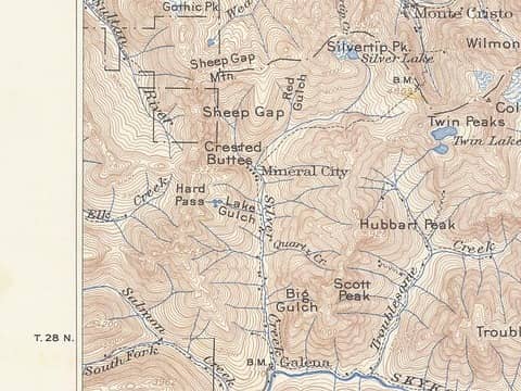
hiked up to mineral city area on Saturday the 18th. Due to recent rains I think we were hiking in the stream bed instead of a trail. Much of the way was flowing water. This being my first time in the area I knew nothing to look for. We got to the area where I believe Mineral City sat, though there is nothing left, and had to negotiate the very fast flowing creek. A big log 50 yards up stream provided a good crossing point. We continued up to explore the valley further after crossing silver creek and starting up the south side of the creek we encountered a continual flowing trail for the next 1/2 mile or so. Beyond that we got to a very beautiful rock slide area with a clear view across the valley to Silver Tip Mtn. We stopped at this point because of time constraints. The valley is beautiful with all the waterfalls.
I only have a couple of questions for anyone out there who knows. Where did mineral city actually sit from where the road enters the area? We didn't have time to explore this area.
From the rock slide area where we turned around, how much further and what are the conditions like to Poodle Dog Pass?
For those willing to share, what are the best things to look for on a future trip into this valley and crossing to Monte Cristo?
|
| Back to top |
  
|
|
MooseAndSquirrel
Member

Joined: 10 Nov 2002
Posts: 2036 | TRs | Pics
|
Guess I'm a bit confused about your route & compass directions- Silver Creek runs in northerly/southerly direction so when you describe being on the north or south side of the creek that doesn't make sense to me.??
Mineral City site is the general area right before the road/trail is interrupted by a fairly large side stream that flows from the west to merge with Silver Creek on your right. You can make out the road again on the other side. This tributary stream can be pretty tough to cross in high water- is this what you may have crossed on a log? There isn't anything left of Mineral City to speak of like artifacts, etc. I've only been as far as that side stream. For further info on the route to Poodle Dog Pass there was cheakamus' report a couple posts before in this thread as well as frankm3 I believe has been up there recently.
|
| Back to top |
|
|
Grinch
Local Burger Tester
Joined: 03 Oct 2003
Posts: 453 | TRs | Pics
Location: Issaquah, WA |
|
Grinch
Local Burger Tester
|
Sun Oct 19, 2003 9:27 pm |
|
|
After you cross the creek at Mineral City on the big log, the trail continues up the valley which at that point is in an east-west orientation.
Sad to hear that the city is all gone, I was hoping that on a return trip there would be old mining relics and foundations and such to piece together the history of the area.
|
| Back to top |
|
|
cheakamus
Member
Joined: 19 Jul 2003
Posts: 331 | TRs | Pics
Location: Seattle |
|
cheakamus
Member
|
Mon Oct 20, 2003 1:29 pm mineral city-poodle dog pass
|
|
|
I don't really know what I'm doing here, but try this.
It a site where early USGS maps are archived. It doesn't seem to work quite right (e.g., the map grid is off by two or three squares, so you have to click on the Olympic Peninsula to bring up the area around Index). One you get there, you can magnify the area around Mineral City, and you will see that even the buildings are marked.
That's the long answer. The short answer is What Moose said.
As for the trail above where you got to--it's probably another couple of miles and another couple of hours, since it's uphill and you have to beat through quite a lot of bush. You cross over to the north side of the river (it's running east west here) and then cross back over to the other side where the river turns north again (at the waterfall). There is a trail the whole way, though it's not always so apparent. Someone's flagged much of the latter half.
For more info on what to see, buy or borrow the book Discovering Washington's Historic Mines.
 mineralcity
|
| Back to top |
|
|
cheakamus
Member
Joined: 19 Jul 2003
Posts: 331 | TRs | Pics
Location: Seattle |
I should have mentioned--the trail shown on this map is not the present-day trail to Poodle Dog Pass but the old trail to Monte Cristo via Pearsall Pass and 76 Gulch.
|
| Back to top |
|
|
MooseAndSquirrel
Member
Joined: 10 Nov 2002
Posts: 2036 | TRs | Pics
|
Thanks for that, Cheakamus. A question- when you say the trail crosses Silver Crk. a couple times further up valley- is that on bridges or do you have to ford the creek at anytime heading up to Poodle Dog Pass? Thanks! M&S
|
| Back to top |
|
|
cheakamus
Member
Joined: 19 Jul 2003
Posts: 331 | TRs | Pics
Location: Seattle |
Hi Moose,
You cross Silver Creek three times after Mineral City--the first time on an old logging bridge just a few hundred yards from the townsite, then twice more where you have to ford the creek. I think the second ford (near the waterfall) might be the more difficult one in high water. However, if you were able to ford the tributary creek at the townsite, I expect you might be okay further up.
Good luck!
|
| Back to top |
|
|
MooseAndSquirrel
Member
Joined: 10 Nov 2002
Posts: 2036 | TRs | Pics
|
Thanks for that info, Cheak. I won't be doing anything up there until next year probably. Thanks, M&S
|
| Back to top |
|
|
Tom
Admin
Joined: 15 Dec 2001
Posts: 17851 | TRs | Pics
|
|
Tom
Admin
|
Mon Oct 20, 2003 4:23 pm |
|
|
Wow, what a great link cheakamus. I've been poking around the interactive map and it's interesting comparing to current maps. Lots of stuff there (i.e. route up hanging valley between overcoat and summit chief) and plenty missing (i.e. no overcoat lake, perhaps a glacier back in 1902).
|
| Back to top |
|
|
-lol-
Member
Joined: 17 Dec 2001
Posts: 767 | TRs | Pics
|
|
-lol-
Member
|
Mon Oct 20, 2003 4:59 pm |
|
|
|
| Back to top |
|
|
cheakamus
Member
Joined: 19 Jul 2003
Posts: 331 | TRs | Pics
Location: Seattle |
Yes, that's the main page, but at least on my browser, you don't always get what you're looking for, i.e., the grid is off by a couple of squares. But if you play around with it, you should get what you want eventually.
|
| Back to top |
|
|
Tom
Admin
Joined: 15 Dec 2001
Posts: 17851 | TRs | Pics
|
|
Tom
Admin
|
Tue Oct 21, 2003 1:07 pm |
|
|
The other problem with the main page is the clickable map graphic is almost 3 MB when it could easily be 1/20th that size. It takes about 20 minutes to download on dialup.  Then again, I guess it shouldn't surprise anyone - the wazzu folks put this one together. Then again, I guess it shouldn't surprise anyone - the wazzu folks put this one together. 
|
| Back to top |
|
|
chris_NWUE
Member

Joined: 04 May 2004
Posts: 42 | TRs | Pics
Location: everett washshington |
|
chris_NWUE
Member
|
Tue May 04, 2004 6:52 pm mineral city / silver creek
|
|
|
A group of us have been doing trail work for about 3 years now on silver creek and plan to do more this summer also plan to camp in mineral city and do some cleenup and more trail work hope you enjoy the cleaner and easyer trail.
|
| Back to top |
|
|
Newt
Short Timer
Joined: 21 Dec 2001
Posts: 3176 | TRs | Pics
Location: Down the road and around the corner |
|
Newt
Short Timer
|
Tue May 04, 2004 7:14 pm |
|
|
Good going Chris. Are you working on the MC trail or something on Silver Creek?. Don't leave andy flags tho. Someone will takem down for ya.
Did you guys put in the bridge?
Newt
It's pretty safe to say that if we take all of man kinds accumulated knowledge, we still don't know everything. So, I hope you understand why I don't believe you know everything. But then again, maybe you do.
It's pretty safe to say that if we take all of man kinds accumulated knowledge, we still don't know everything. So, I hope you understand why I don't believe you know everything. But then again, maybe you do.
|
| Back to top |
|
|
Dogpatch
Member

Joined: 17 Aug 2003
Posts: 1588 | TRs | Pics
Location: the dryside |
|
Dogpatch
Member
|
Tue May 04, 2004 7:17 pm |
|
|
| chris_NWUE wrote: | | A group of us have been doing trail work for about 3 years now on silver creek |
Wow. That's really good news. Any idea how the trail/road up there fared this winter?
"Outside of a dog, a book is man's best friend.
Inside of a dog, it's too dark to read." Groucho Marx
"Outside of a dog, a book is man's best friend.
Inside of a dog, it's too dark to read." Groucho Marx
|
| Back to top |
|
|
|
|


