| Previous :: Next Topic |
| Author |
Message |
Randy
Cube Rat


Joined: 18 Dec 2001
Posts: 2910 | TRs | Pics
Location: Near the Siamangs |
|
Randy
Cube Rat
|
 Sat Jul 19, 2003 9:16 pm |
|
|
Wandered up Mount Daniel today with Craig B. We left the trailhead at 0800 and made good time up to Peggy's Pond. We found the climber's path to the NW of the lake and lazily made our way up the easy SE ridge. About 3/4 of the way up, the path enters the large snow basin just below the east peak. We cut across the basin and then straight up a couple hundred feet to the 7600' pass just south of the east peak. From here we followed another faint path up, down, and around the summit plateau to just SW of the middle peak. We could see another party summiting the west peak (true summit), so we held up a bit and I made the quick climb up to the top of the middle peak then quickly descended back to my pack. Continuing on, we bumped over to the west peak, dropped packs and made the quick walk to the top. Awesome views on this absolutely perfect weather day. Took a bunch of pictures then descended back to our packs for some junk food and rest.
After about an hour on top, we left the west peak around 1345 and followed our same route back to the 7600' pass. Here I dropped my pack (again!) and hurried my way up to the top of the east peak - snapped a few photos and then hurried down. Most of the rest of the way back was on trail and didn't vary much from our ascent route. The last couple of miles got a bit old as all we wanted to do was get out of the heat, but all went well and we were back at the trailhead just before 1730. Great day, great company.
|
| Back to top |
  
|
|
Chowder1974
Member

Joined: 15 Jul 2003
Posts: 13 | TRs | Pics
|
|
Chowder1974
Member
|
Mon Jul 21, 2003 8:15 am Conditions at Peggy's Pond
|
|
|
Randy -
I'm planning a trip up to that area next weekend. How were the conditions at Peggy's Pond? Was it completely melted out? Was there much if any snow left?
I'm planning on heading over to Circle lake.
Thanks for your help.
|
| Back to top |
|
|
RandyB
Guest
|
|
RandyB
Guest
|
Mon Jul 21, 2003 11:27 am |
|
|
| Chowder1974 wrote: | | Randy -
I'm planning a trip up to that area next weekend. How were the conditions at Peggy's Pond? Was it completely melted out? Was there much if any snow left?
I'm planning on heading over to Circle lake.
Thanks for your help. |
No snow around Peggy's Pond and it was completely melted out. Circle was 60-70% melted out. Venus and Spade were completely thawed. Pea Soup was 70-80% thawed. Lots of horrible bugs at Peggy's Pond - we didn't envy the people using it as a base camp for a two day assualt on Daniel.
|
| Back to top |

|
|
Chowder1974
Member
Joined: 15 Jul 2003
Posts: 13 | TRs | Pics
|
|
Chowder1974
Member
|
Mon Jul 21, 2003 11:42 am Traverse over to circle
|
|
|
Thanks for the update Randy!
How did the traverse over to Circle Lake look? Did this look like it was snow free? What about the ridge between Circle and Venus? Was there any snow there?
I was also thinking about climbing the Citadel. I havent done any mountaineering, just backpacking. Did this look to be snow free? Does it require any ropes or other technical climbing abilities / equipment?
Thank you very much for your help!
|
| Back to top |
|
|
RandyB
Guest
|
|
RandyB
Guest
|
Mon Jul 21, 2003 12:53 pm |
|
|
| Chowder1974 wrote: | | Thanks for the update Randy!
How did the traverse over to Circle Lake look? Did this look like it was snow free? What about the ridge between Circle and Venus? Was there any snow there?
I was also thinking about climbing the Citadel. I havent done any mountaineering, just backpacking. Did this look to be snow free? Does it require any ropes or other technical climbing abilities / equipment?
Thank you very much for your help! |
That south slope looks pretty snow free - very little (if any) snow around Circle. More snow on the route over and down to Venus.
I will be climbing the Citadel on 8/1. The last 30-50' are reported class 4, but I do not know what the exposure is like. Expect snow on the way up to the summit. There was still significant snow on the main route when I looked at it. I will be bringing my axe, but no rope - but that's a personal judgement call.
|
| Back to top |
|
|
Mike Collins
Member
Joined: 18 Dec 2001
Posts: 3097 | TRs | Pics
|
Randy...I did the Citadel about 1 month ago. I seem to remember Beckey describing a route up from the SE. I did not find his described route. My final approach meant I had to move into the drainage for Venus Lake. So traverse from Peggy's Pond to Circle Lake. Cross the outflow. Ascend toward Citadel and within 200 vertical of the summit swing around to the north of Citadel and cross from Circle Lake drainage over to Venus Lake drainage. The Class 4 rock which you will see is quite doable and limited.
|
| Back to top |
|
|
Randy
Cube Rat
Joined: 18 Dec 2001
Posts: 2910 | TRs | Pics
Location: Near the Siamangs |
|
Randy
Cube Rat
|
Mon Jul 21, 2003 7:47 pm |
|
|
Some Pictures!
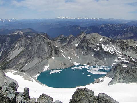 PeaSoup 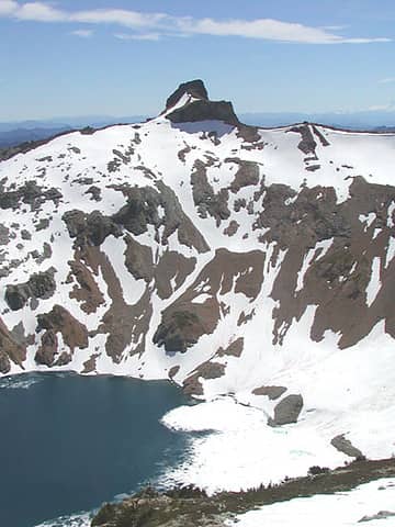 The Citadel 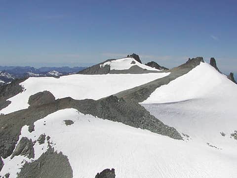 Summit Plateau 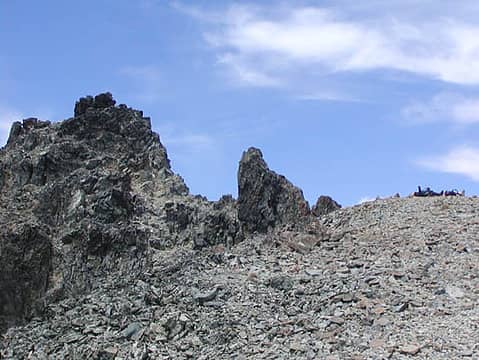 Craig Sleeping Near Summit
|
| Back to top |
|
|
Randy
Cube Rat
Joined: 18 Dec 2001
Posts: 2910 | TRs | Pics
Location: Near the Siamangs |
|
Randy
Cube Rat
|
Mon Jul 21, 2003 7:52 pm |
|
|
| Mike Collins wrote: | | Randy...I did the Citadel about 1 month ago. I seem to remember Beckey describing a route up from the SE. I did not find his described route. My final approach meant I had to move into the drainage for Venus Lake. So traverse from Peggy's Pond to Circle Lake. Cross the outflow. Ascend toward Citadel and within 200 vertical of the summit swing around to the north of Citadel and cross from Circle Lake drainage over to Venus Lake drainage. The Class 4 rock which you will see is quite doable and limited. |
Mike see the picture in my previous post. So, I can't ascend the snow ramp on the left and come right up under the final summit block? I have to traverse around the lower walls and over the ridge just to the right of the main Citadel formation?
|
| Back to top |
|
|
Mike Collins
Member
Joined: 18 Dec 2001
Posts: 3097 | TRs | Pics
|
Randy...Yes the route you describe is the way. Jump on top of the corniced snow at the end of the ramp and then go over to the summit block. It is easier than your picture suggests. I don't have my Beckey with me at the hospital but I seem to remember him talking about a route from the SE. Forget it. The route up the summit block is from the NW or the North.
|
| Back to top |
|
|
Randy
Cube Rat
Joined: 18 Dec 2001
Posts: 2910 | TRs | Pics
Location: Near the Siamangs |
|
Randy
Cube Rat
|
Mon Jul 21, 2003 8:40 pm |
|
|
Thanks for the beta Mike.
You sneak out and see T3 yet? How about the pirate movie? It's safe here, you can tell the truth.
|
| Back to top |
|
|
Dean
(aka CascadeHiker)

Joined: 02 Mar 2002
Posts: 1967 | TRs | Pics
Location: ex Kennewick, Wa & Lehi Utah |
|
Dean
(aka CascadeHiker)
|
Mon Jul 21, 2003 9:35 pm |
|
|
Randy: I'm planning to do this one the second weekend in August. Did you need to use an ice axe or even have one? I plan to do this solo/ Any suggestions if any?
BTW, nice pics. I rate T3 as a B+ (T2 was an A and the best of the 3 ) Don't waste your money on "League of Extraordinary Gentlemen" - (its a video rental)
|
| Back to top |
|
|
Mike Collins
Member
Joined: 18 Dec 2001
Posts: 3097 | TRs | Pics
|
Sorry for thread drift...I had a pass from the hospital on Saturday night. The heat was oppressive and domineering though. On Sunday we sought refuge at the movie theatre. We saw "Searching for Nemo" but got there 30 minutes early so we could see the chase scene for T3. Cindy actually thinks that with my head scars I am a dead ringer for the Terminator. Hey, anytime you fall off a mountain and come back looking like Aaaahnold is a lucky day. Thanks for asking . I am to be discharged from the hospital tomorrow. I should ask the Forest Service if my handicapped parking card for the rearview mirror counts as a Trailpass. Wow! This falling off the mountain could be the best part of my summer. Who would have thought?
|
| Back to top |
|
|
RandyB
Guest
|
|
RandyB
Guest
|
Tue Jul 22, 2003 11:30 am |
|
|
| CascadeHiker wrote: | | Randy: I'm planning to do this one the second weekend in August. Did you need to use an ice axe or even have one? I plan to do this solo/ Any suggestions if any?
BTW, nice pics. I rate T3 as a B+ (T2 was an A and the best of the 3 ) Don't waste your money on "League of Extraordinary Gentlemen" - (its a video rental) |
I would bring an axe and that's it. The snow basin above the Hyas "Glacier" will still be there and there was one kind-of steep section that you'll need to traverse to get into the basin proper. Other than the snow basin you'll be walking on a lot of scree. Easy trip.
|
| Back to top |
|
|
Backpacker Joe
Blind Hiker

Joined: 16 Dec 2001
Posts: 23956 | TRs | Pics
Location: Cle Elum |
Chowder, i've made that traverse from Circle over to Venus twice. Be careful as you top that ridge just under the summit block. If you let go there and cant arrest, you're a goner. It's not that steep, but it ends at the lake. That's the only real spot to be concerned about. On the other side work your way down and in a northerly direction onto a ramp. Stay on that ramp and work your way north until you are above Venus. Then head sharp south west and work your way down to Venus's outlet. There is one spot that you have to find that allows you to get around a cliff band.
TB
"If destruction be our lot we must ourselves be its author and finisher. As a nation of freemen we must live through all time or die by suicide."
Abraham Lincoln
"If destruction be our lot we must ourselves be its author and finisher. As a nation of freemen we must live through all time or die by suicide."
Abraham Lincoln
|
| Back to top |
|
|
|
|


