| Previous :: Next Topic |
| Author |
Message |
Sawyer
Guest

|
|
Sawyer
Guest
|
 Wed May 15, 2002 11:00 pm |
|
|
Funny, the .tpo file showed up the next day. Wasn't there when I checked right after submitting. So here goes another attempt to upload the .jpg version for those w/o Topo!.
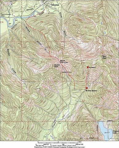 MarblePass
|
| Back to top |
  
|
 |
Scrooge
Famous Grouse

Joined: 16 Dec 2001
Posts: 6966 | TRs | Pics
Location: wishful thinking |
|
Scrooge
Famous Grouse
|
Thu May 16, 2002 8:12 am |
|
|
It's too bad about the South Shore Road. That really puts a crimp in things. It certainly delays any activity until midsummer, when the north side of some of these ridges may melt out.
In the mean time: Ice Girl, in thinking about the water route, it occurs to me that canoes make more sense than kayaks, A canoe will hold two or three people and all the gear they can carry. Back in the dim, distant past, I used to do weekends on the islands in Lake George (New York) that way, and it worked fine.
On the Sultan River approach: I've forded the Sultan in early August, right where the Sultan River Road used to cross it. No special problem, I used ski poles and didn't even get my shorts wet. The problem is after you get across.It's typical westside jungle and you're talking a minimum 1 1/2 mile bushwhack to get over to the Williamson Creek Road. If I'm gonna bushwhack, I'd rather do it on one of the routes that has some intrinsic interest.
On the Vesper Peak route (again, briefly): it's about 7 miles and 4500', in and out! And it also includes more than a mile of travel only appropriate for experienced mountaineers.
Sawyer's Marble Pass route will probably work, but reported experience suggests that it's more appropriate as a project in its own right than as a means to get somewhere to begin exploration.
There is one viable alternative to the North Shore Road, although it's not necessarily easier: Walt Bailey's Trail all the way to the Bald Mountain Trail; east on the abandonned section of the BMT to the old trailhead; down the spur road to Williamson Creek(which has probably been trenched and may have had two bridges removed); and up the old Williamson Creek Road to the base of the Copper outlet.
I have hiked all of that except the old Williamson Creek Road, itself. The whole route would run about 11 miles and 2800' in, 3800' out. The condition of some sections is uncertain.
By way of contrast, the North Shore Road route, itself, would run a long 12 miles but only 1600' in, 800' out - and no uncertainty ...... but no fun, either.  I'm inclined to wait till I can take a boat: a mile on the water and less than 5 miles and 800' up the Williamson Creek Road to the base of the Copper outlet.
Something lost behind the ranges. Lost and waiting for you....... Go and find it. Go!
Something lost behind the ranges. Lost and waiting for you....... Go and find it. Go!
|
| Back to top |

|
|
Ice Girl
Member
Joined: 30 Apr 2002
Posts: 291 | TRs | Pics
|
|
Ice Girl
Member
|
Thu May 16, 2002 8:46 am |
|
|
i haven't been up on the rd. (Bald Mt.)that goes down to WC in quite i while, i couldn't say if they took out colverts. i can say when i was there it was in pretty bad shape then. i know of one big bridge across WC, i am not sure if they would take it out. (you never know what extents they will go to). But even if they did we could just go across at some point. i am glad you agree with me on the Vesper route. i really don't think i would be going if we went that way. i have no experience with any stuff like that, not that i am not willing to learn.
Ice Girl 
|
| Back to top |
|
|
Scrooge
Famous Grouse

Joined: 16 Dec 2001
Posts: 6966 | TRs | Pics
Location: wishful thinking |
|
Scrooge
Famous Grouse
|
Thu May 16, 2002 2:38 pm |
|
|
The bridge across Williamson Creek is concrete and would probably be left. At least, I've never seen an instance where they demolished one of those.
The two bridges I'm talking about are across tributarys up on the spur and are kind of interesting. They're made of wood, unit construction, and are designed to be lifted in and out by helicopter (there are four metal loops recessed in the bridge deck, perfactly placed for cable hook-up). I assume the idea was to have a reusable design that could be moved from site to site to reduce the cost of building logging spurs. I can't recall ever seeing a place where such a bridge was removed. The one-size-fits-all concept may not have worked out, or the cost/ease-of-installation advantage may have proved marginal.
As far as trenching that spur is concerned, several years ago I talked to the DNR engineer in charge of road demolition. He said that that spur was slated for trenching (culvert removal), along with many others in the area. Unfortunately, DNR has in fact been religious about destroying the logging spurs in Sultan Basin.  By now, everybody must be tired of hearing me wrant about this atrocity. As far as I'm concerned it is a criminal waste of what ought to be a superb recreational facility. .... Not to mention the fact that it interferes with my personal desire to get back up Williamson Creek. By now, everybody must be tired of hearing me wrant about this atrocity. As far as I'm concerned it is a criminal waste of what ought to be a superb recreational facility. .... Not to mention the fact that it interferes with my personal desire to get back up Williamson Creek. 
Something lost behind the ranges. Lost and waiting for you....... Go and find it. Go!
Something lost behind the ranges. Lost and waiting for you....... Go and find it. Go!
|
| Back to top |
|
|
Ice Girl
Member
Joined: 30 Apr 2002
Posts: 291 | TRs | Pics
|
|
Ice Girl
Member
|
Thu May 16, 2002 4:05 pm |
|
|
Ha...Ha... good post, so i quess that is a "YES" for sure on you going if we get this thing any further than the drawing board..
i am excited and want to go now.....
Ice Girl
|
| Back to top |
|
|
Ice Girl
Member
Joined: 30 Apr 2002
Posts: 291 | TRs | Pics
|
|
Ice Girl
Member
|
Thu May 16, 2002 8:46 pm |
|
|
Alright, i just talk to that friend of mine that i use to live with up at WC. This is the scoop, he says, the one from Cutthroat lakes is a bummer. He say Marble Pass, isn't to hot. (i forgot to mention lake way). But he says Headlee Pass, to Vesper is not the way either, like Scrooge said you have to be Mt. Goat, or experienced with repelling. But he told me of another way that would work if you want to go to the lake. He says go up Headlle Pass and then instead of going to Vesper you head right (over towards a eagle lake, i think he said), and go up to the saddle and go down that way, he say you would need a rope, because some of it is steep, but you can do it. He might even be willing to go with us.
Now on the 45 mines there is at least 5 of them and he has the maps to them in his garage, and might be able to dig them out by mid summer. This guy know (this area better than i do). So this gives us more to think about...
Ice Girl
|
| Back to top |
|
|
Best Bet
Guest
|
|
Best Bet
Guest
|
Fri May 17, 2002 9:20 am |
|
|
In 1990, we drove the road high above Williamson Creek to do Bald, and in Feb '91 made a rare winter/any-kind ascent of Little Chief Peak, just south of Copper Lake. But those open-road days are gone.
Here's a two-penny thought on how to get to Copper Lake nowadays. Spare yourselves the grief of Marble Pass, the long trek over Bald, the annoying gutted road walk around Spada, and do the brush-free, trailed, straightforward route in over Headlee Pass from Sunrise Mine road, as others have mentioned. There's a trail into the basin between Vesper and Sperry (not shown on USGS). Learn the basics of ice ax use (not that hard/practice on the way), go early in the year, take a strong step-kicker, and put your feet in his prints. Take a rope just in case. The contours into the skinny Vesper Glacier don't look that worrisome, and the crevasses will be filled in (the Terraserver aerial was taken in September). Should be a piece of cake.
http://www.topozone.com/map.asp....er+Peak
|
| Back to top |
|
|
#19
Member
Joined: 17 Dec 2001
Posts: 2197 | TRs | Pics
|
|
#19
Member
|
Fri May 17, 2002 10:01 am |
|
|
I don't feel like counting lines, but I think its less than 4500' elevation gain to the Vesper / Sperry Col. Maybe 4500' to the top of Vesper.
On the other hand, many of the regulars here are "checked out" on ice axe travel, but it's not an option for others and they don't have the desire to.
|
| Back to top |
|
|
Sore Feet
Member

Joined: 16 Dec 2001
Posts: 6307 | TRs | Pics
Location: Out There, Somewhere |
I think I'd much rather do the trek from Bald Mtn or Walts Bailey or the North Shore than deal with technical climbing and stuff, easy as it may be.
|
| Back to top |
|
|
sawyer
Guest
|
|
sawyer
Guest
|
Fri May 17, 2002 11:43 am |
|
|
Having unfinished business on Marble Pass, I plan to tackle it again this year. Have some buddies also interested. And drop down to the 45 mine. I'd love to see the mine maps, Ice Girl. There are also maps in "Discovering Washington's Historic Mines, Vol I".
BTW, Vol 2 has been advertised on the Oso Press website. Anyone know how to get a copy? It covers the east side of the crest.
|
| Back to top |
|
|
-lol-
Member
Joined: 17 Dec 2001
Posts: 767 | TRs | Pics
|
|
-lol-
Member
|
Fri May 17, 2002 12:23 pm |
|
|
|
| Back to top |
|
|
-lol-
Member
Joined: 17 Dec 2001
Posts: 767 | TRs | Pics
|
|
-lol-
Member
|
Fri May 17, 2002 3:03 pm |
|
|
|
| Back to top |
|
|
Ice Girl
Member
Joined: 30 Apr 2002
Posts: 291 | TRs | Pics
|
|
Ice Girl
Member
|
Fri May 17, 2002 7:13 pm |
|
|
i think we should do some more checking out before we deside what way we want to go. Maybe do some trial run in different direction, before we get all loaded down and ready to go.
Ice Girl 
|
| Back to top |
|
|
Hulksmash
Cleaning up.

Joined: 20 Apr 2008
Posts: 7113 | TRs | Pics
Location: Arlington |
|
Hulksmash
Cleaning up.
|
Sat Sep 26, 2009 10:05 pm |
|
|
This thread needs a BUMP.
Last weekend while my trek along the Walt Bailey trail i noticed what appeared to be a gap between Mallardy ridge and the NE shoulder of Bald mtn at the far end of the Meadow.
 Meadow 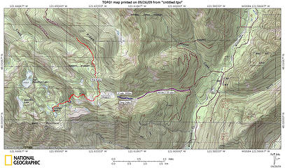 Willamson Creek Route  Well here's what i found. There is a narrow gully, between the two ridges, the gully it self is flanked by cliff bands. It reminds me a bit of Headlee Pass...only with out switch backs, add brush. So yes it's steep, according to the Topo, it drops, about 900 feet in .25 of a mile. The soil is kind of loose, but the brush seems to hold it in place. The brush it's self for the most part, is only waist high. It is heavily browsed by game. Goats? It seems naturally funnel game into a small area. The gully is a maze of game paths. I only went half way down. But i see no evidence of any cliff bands with in the gully.
  At the bottom of the gully about 900 feet, the grade eases drastically. To a talus field, then giving way to blue berry heaven. Not slide alder hell. Then to forest. At the bottom of the gully about 900 feet, the grade eases drastically. To a talus field, then giving way to blue berry heaven. Not slide alder hell. Then to forest.
 Williamson Creek Drainage 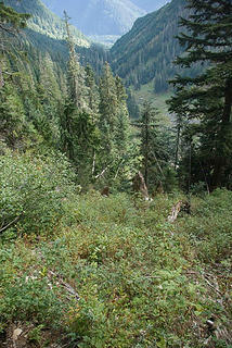 Looking down Gulley 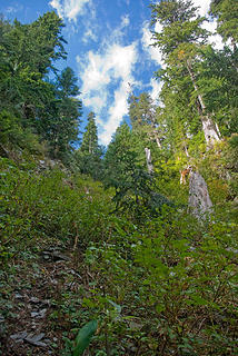 Looking up Gulley
"Bears couldn't care less about us....we smell bad and don't taste too good. Bugs on the other hand see us as vending machines." - WetDog
Albuterol! it's the 11th essential
"Bears couldn't care less about us....we smell bad and don't taste too good. Bugs on the other hand see us as vending machines." - WetDog
Albuterol! it's the 11th essential
|
| Back to top |
|
|
Schroder
Member

Joined: 26 Oct 2007
Posts: 6722 | TRs | Pics
Location: on the beach |
|
Schroder
Member
|
Sat Sep 26, 2009 11:40 pm |
|
|
I was thinking along those lines too, Hulk, except going over the top of that hill from the meadow and hooking onto that Everett Creek road as high as possible
|
| Back to top |
|
|
|
|
You cannot post new topics in this forum
You cannot reply to topics in this forum
You cannot edit your posts in this forum
You cannot delete your posts in this forum
You cannot vote in polls in this forum
|
Disclosure: As an Amazon Associate NWHikers.net earns from qualifying purchases when you use our link(s). |


