| Previous :: Next Topic |
| Author |
Message |
Hulksmash
Cleaning up.


Joined: 20 Apr 2008
Posts: 7113 | TRs | Pics
Location: Arlington |
|
Hulksmash
Cleaning up.
|
 Sat Sep 26, 2009 11:46 pm |
|
|
I kind of made an attempt to do that too. Quickly ran into cliff bands. It may be possible though. I just don't see the point now.
If i can drag my butt out of bed early enough tomorrow. I might make a shot to at maximum copperlake falls. My estimate put it at about 14 miles or so round trip.
"Bears couldn't care less about us....we smell bad and don't taste too good. Bugs on the other hand see us as vending machines." - WetDog
Albuterol! it's the 11th essential
"Bears couldn't care less about us....we smell bad and don't taste too good. Bugs on the other hand see us as vending machines." - WetDog
Albuterol! it's the 11th essential
|
| Back to top |
  
|
|
Hulksmash
Cleaning up.
Joined: 20 Apr 2008
Posts: 7113 | TRs | Pics
Location: Arlington |
|
Hulksmash
Cleaning up.
|
Sat Sep 26, 2009 11:57 pm |
|
|
From Vesper it is a climber route. Requiring ropes.
"Bears couldn't care less about us....we smell bad and don't taste too good. Bugs on the other hand see us as vending machines." - WetDog
Albuterol! it's the 11th essential
"Bears couldn't care less about us....we smell bad and don't taste too good. Bugs on the other hand see us as vending machines." - WetDog
Albuterol! it's the 11th essential
|
| Back to top |
|
|
Schroder
Member

Joined: 26 Oct 2007
Posts: 6722 | TRs | Pics
Location: on the beach |
|
Schroder
Member
|
Sun Sep 27, 2009 1:36 pm |
|
|
It looks straightforward from Google Earth. There's a logging spur part way up that drainage
|
| Back to top |
|
|
Scrooge
Famous Grouse

Joined: 16 Dec 2001
Posts: 6966 | TRs | Pics
Location: wishful thinking |
|
Scrooge
Famous Grouse
|
Sun Sep 27, 2009 3:25 pm |
|
|
Somewhere, we got a link to a report by a group of mine buffs who went over Marble Pass and down to the 45 Mine, without technical problems ....... but I can't find it.  Anybody remember where that is? It might help you develop your plans a little further.
Last fall, Sultan Guy made it up to the Copper Lake outfall via Williamson Creek. - https://www.nwhikers.net/forums/viewtopic.php?t=7970026&highlight=williamson+creek - It was a fairly brutal bushwhack, which mainly proved that the Copper outfall was not as impressive a waterfall as we'd imagined. Anybody remember where that is? It might help you develop your plans a little further.
Last fall, Sultan Guy made it up to the Copper Lake outfall via Williamson Creek. - https://www.nwhikers.net/forums/viewtopic.php?t=7970026&highlight=williamson+creek - It was a fairly brutal bushwhack, which mainly proved that the Copper outfall was not as impressive a waterfall as we'd imagined.
Something lost behind the ranges. Lost and waiting for you....... Go and find it. Go!
Something lost behind the ranges. Lost and waiting for you....... Go and find it. Go!
|
| Back to top |
|
|
Schroder
Member
Joined: 26 Oct 2007
Posts: 6722 | TRs | Pics
Location: on the beach |
|
Schroder
Member
|
Sun Sep 27, 2009 3:52 pm |
|
|
Scrooge - Hulk & I went to Marble Pass last year. It's a long way down from there.
Sultan Guy went very late in the year when there was almost no flow out of Copper Lake & he was also not on the old trail -where you get the best perspective. Here's a reminder
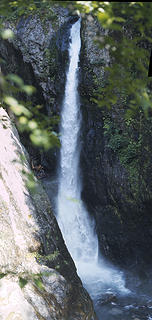 Falls on Copper Lake Trail
|
| Back to top |
|
|
captain jack
Serving suggestion

Joined: 25 May 2004
Posts: 3389 | TRs | Pics
Location: Upper Fidalgo |
| Scrooge wrote: | | Somewhere, we got a link to a report by a group of mine buffs who went over Marble Pass and down to the 45 Mine, without technical problems ....... but I can't find it. Anybody remember where that is? It might help you develop your plans a little further. |
This one David ?
http://nwue.org/archives/2007/09/45_mine_recon.html
|
| Back to top |
|
|
H. Hound
Member

Joined: 09 May 2003
Posts: 1205 | TRs | Pics
Location: Exit 32 |
|
H. Hound
Member
|
Sun Sep 27, 2009 6:18 pm |
|
|
And they did it again this year.
Part one
Part two
I think a helicopter is the the onle way I'd be getting into that area.
|
| Back to top |
|
|
Scrooge
Famous Grouse
Joined: 16 Dec 2001
Posts: 6966 | TRs | Pics
Location: wishful thinking |
|
Scrooge
Famous Grouse
|
Sun Sep 27, 2009 7:46 pm |
|
|
Thanks, CJ, that's certainly the group and the trip that I'm remembering, though I thought the level of detail was more like the pair H. Hound provided from this year. Probably I thought just the fact of the trip was impressive detail.  In any event, I've always been in the Williamson Creek faction, so I may not pay as much attention to alternate route reports as I ought.
Randy, the thing about the Copper outfall is that it's at too low an angle. The deep slot canyon had fooled us into believing that there was a series of awesome waterfalls hidden back in the shadows. In fact, it's just a long cascade ending in your pictured waterfall. Still a neat place, but not quite the scenic magnet we'd imagined. In any event, I've always been in the Williamson Creek faction, so I may not pay as much attention to alternate route reports as I ought.
Randy, the thing about the Copper outfall is that it's at too low an angle. The deep slot canyon had fooled us into believing that there was a series of awesome waterfalls hidden back in the shadows. In fact, it's just a long cascade ending in your pictured waterfall. Still a neat place, but not quite the scenic magnet we'd imagined.
Something lost behind the ranges. Lost and waiting for you....... Go and find it. Go!
Something lost behind the ranges. Lost and waiting for you....... Go and find it. Go!
|
| Back to top |
|
|
Hulksmash
Cleaning up.
Joined: 20 Apr 2008
Posts: 7113 | TRs | Pics
Location: Arlington |
|
Hulksmash
Cleaning up.
|
Sun Sep 27, 2009 7:56 pm |
|
|
"Bears couldn't care less about us....we smell bad and don't taste too good. Bugs on the other hand see us as vending machines." - WetDog
Albuterol! it's the 11th essential
|
| Back to top |
|
|
Schroder
Member
Joined: 26 Oct 2007
Posts: 6722 | TRs | Pics
Location: on the beach |
|
Schroder
Member
|
Sun Sep 27, 2009 8:54 pm |
|
|
| Hulksmash wrote: | Randy, you might want to rethink trying to connect with one of those spur roads on the edge of that creek drainage. Once descending that gully it's a steep climb back up to those spurs. It's hard to see in the photo, but the ends of those spurs are visible from the gully.
Unfortunately i fear the fair weather window for exploring that area is gone.  Getting soaking wet in the brush during the day, when the temps could possibly plunge to near freezing sounds like trouble. Getting soaking wet in the brush during the day, when the temps could possibly plunge to near freezing sounds like trouble. |
If you look at the topo map there's a spur right on the creek - barely visible in Google Earth that goes up to that large clear area on the east edge of the creek. I agree that the climb out of the gully looks pretty steep.
|
| Back to top |
|
|
Hulksmash
Cleaning up.
Joined: 20 Apr 2008
Posts: 7113 | TRs | Pics
Location: Arlington |
|
Hulksmash
Cleaning up.
|
Sat Oct 03, 2009 7:13 pm |
|
|
I decided to take one more stab at Randy's suggestion at taking the high route to one of the spur roads off of Williamson creek. Although my main goal was to look for the old Mallardy ridge trail. I accomplished none of my goals. I did manage to travel 2 miles the top of Mallardy ridge. I did not find on singe shred of evidence that a trail ever existed on the top of the ridge, or at least the portion i was on. While i did not reach any road, i believe going up and over the hill could be a viable route down to Williamson creek.
"Bears couldn't care less about us....we smell bad and don't taste too good. Bugs on the other hand see us as vending machines." - WetDog
Albuterol! it's the 11th essential
"Bears couldn't care less about us....we smell bad and don't taste too good. Bugs on the other hand see us as vending machines." - WetDog
Albuterol! it's the 11th essential
|
| Back to top |
|
|
GeoHiker
Rocky Walker
Joined: 26 Feb 2005
Posts: 6033 | TRs | Pics
Location: Off the Deep End |
|
GeoHiker
Rocky Walker
|
Sat Oct 03, 2009 8:55 pm |
|
|
You guys have to stop these posts! Every time this comes up the wheels start spinning. Hmmm, next week is going to be sunny and clear.......I was just looking at the DNR website and there's not an ounce of info. on what's happening with the S. Shore road in the Sultan Basin. At least I can't find anything.
Anyone heard if the road will open this year? It could have been open months ago with some added blocking if they wanted to drop in some logs or barriers. There wasn't that much damage at least to the first boat launch. The road worker said the road was fine to the rock quarry, so what gives?
If I knew I could drop my kayak in at the east end of the lake I might just spend the week wandering around up there. 
You call some place paradise, kiss it goodbye......Eagles
You call some place paradise, kiss it goodbye......Eagles
|
| Back to top |
|
|
Hulksmash
Cleaning up.
Joined: 20 Apr 2008
Posts: 7113 | TRs | Pics
Location: Arlington |
|
Hulksmash
Cleaning up.
|
Sat Oct 03, 2009 9:09 pm |
|
|
Road information was on the PUD site
I say was because they have "updated" there web site, i can no longer find where the road information located.
The last word i was the road repair would be completed in October, but the PUD typically closes the gate in October.
If it was earlier in the year, i would be spending a few days in the general area too.
"Bears couldn't care less about us....we smell bad and don't taste too good. Bugs on the other hand see us as vending machines." - WetDog
Albuterol! it's the 11th essential
"Bears couldn't care less about us....we smell bad and don't taste too good. Bugs on the other hand see us as vending machines." - WetDog
Albuterol! it's the 11th essential
|
| Back to top |
|
|
GeoHiker
Rocky Walker
Joined: 26 Feb 2005
Posts: 6033 | TRs | Pics
Location: Off the Deep End |
|
GeoHiker
Rocky Walker
|
Sat Oct 03, 2009 9:36 pm |
|
|
Thanks Hulk, I forgot to check the PUD site. I'm sure now that they are in the road business they'll keep us well informed!.....YEAH RIGHT. Wasn't the last update for a mid August opening? I'm sure it's a high priority now that they have ownership.
The road worker did laugh at me when I mentioned that it was "suppose" to be open in August. He said no way this year. Yeah, maybe to put it back to it's former 1 lane freeway status. Throw up a sign or 2 and warn about the damaged road. I won't be able to drive 45 mph and might have to slow down at a few spots. BFD! Open the road NOW...... 
You call some place paradise, kiss it goodbye......Eagles
You call some place paradise, kiss it goodbye......Eagles
|
| Back to top |
|
|
BillyTheMountain
Member

Joined: 17 Sep 2010
Posts: 104 | TRs | Pics
Location: Roxoff, Washington |
The Bald Mountain Trail DOES go East to a road above Williamson Creek from the Walt Baily Trail. You can then hike down to Williamson Creek itself and then turn left and go to the Copper Lake outlet. I know because I built that trail in 1974-78. The boy scouts had built a terrible trail that we fixed(DNR) and continued to the summit, Cutthroat lakes and on to Ashland Lakes.
The trail IS there.
BillyTheMountain
We are all brothers in the mountains.
Psalm 113
We are all brothers in the mountains.
Psalm 113
|
| Back to top |
|
|
|
|


 Yea. About dragging my but out of bed early....that so didn't happen. Alarm was set to 5:30, rolled out of bed at 9:30
  So i didn't go. To make it that distance in one day i would need every minute of day light. Wasted to much of it sleeping
Anyway. There just is no easy way to Copper lake.
The Marble Pass option involves a lot of elevation gain, and a river ford which is only fordable a limited number of months. And a heavy rain can quickly make it sketchy to cross.
A Verper route, is a technical climb
Sultan Basin, requires a canoe, or some sort of approved floating device, and places to park overnight are extremely limited. It's been a year since the general public has been allowed to drive past the gate at Olney Pass.
Walt Bailey is an interesting option without going all the way to Bald mountain it reduces the elevation gain. It's two gentle miles from the trail head to the edge of that gully. There are no overnight restrictions for parking over night at WB. There is no sketchy river ford.
Randy, you might want to rethink trying to connect with one of those spur roads on the edge of that creek drainage. Once descending that gully it's a steep climb back up to those spurs. It's hard to see in the photo, but the ends of those spurs are visible from the gully.
Unfortunately i fear the fair weather window for exploring that area is gone.
So i didn't go. To make it that distance in one day i would need every minute of day light. Wasted to much of it sleeping
Anyway. There just is no easy way to Copper lake.
The Marble Pass option involves a lot of elevation gain, and a river ford which is only fordable a limited number of months. And a heavy rain can quickly make it sketchy to cross.
A Verper route, is a technical climb
Sultan Basin, requires a canoe, or some sort of approved floating device, and places to park overnight are extremely limited. It's been a year since the general public has been allowed to drive past the gate at Olney Pass.
Walt Bailey is an interesting option without going all the way to Bald mountain it reduces the elevation gain. It's two gentle miles from the trail head to the edge of that gully. There are no overnight restrictions for parking over night at WB. There is no sketchy river ford.
Randy, you might want to rethink trying to connect with one of those spur roads on the edge of that creek drainage. Once descending that gully it's a steep climb back up to those spurs. It's hard to see in the photo, but the ends of those spurs are visible from the gully.
Unfortunately i fear the fair weather window for exploring that area is gone.