| Previous :: Next Topic |
| Author |
Message |
MooseAndSquirrel
Member


Joined: 10 Nov 2002
Posts: 2036 | TRs | Pics
|
Seeking info about what to expect when driving in the winter months down to the Palm Springs area using this route: I-5 south to Hwy 89 to 44 to 395 towards Palm Springs. I know about the Siskiyous at the CA/ORE border, and have driven 395 just between Bridgeport and Lone Pine in the summer months (from Yosemite and I-5 direction). Don't know anything about what to expect crossing the northern Sierra/Cascades near Lassen NP in the winter- are any roads/passes closed along this route? On paper this route is faster than I-5-and I hate driving I-5- but in winter I might have little choice if conditions prove bad. Thanks for any info anyone might be able to provide! M&S
|
| Back to top |
  
|
|
Smokey
Member
Joined: 10 Nov 2002
Posts: 792 | TRs | Pics
|
|
Smokey
Member
|
 Sun Aug 03, 2003 6:24 pm |
|
|
Hey M&S, I've driven to So Cal a thousand times it seems. There is no faster way than I-5 any time of the year. Get on, floor it, and try not to get run over. You know the bad parts in Oregon and around Shasta, just try to hit them in the day time. Then your only worry is the tule fog in the valley where you can join the 500 car pile up.
I drove 395 just last spring, beautiful. However you could be in for a long trip if you hit a winter storm. And the CHP requires chains at the first snowflake it seems. Driving any distance with chains on is maddening.
I'm not sure about permanent winter road closures on your route. If you decide to go for it, I'd allow lots of time in your schedule, have some good chains and a repair kit for them, and all your winter camping gear just in case.
Heck, even on I-5 I've encountered flooding, blowing sand, road closures due to snow and ice, black ice, and the dreaded fog which is the thing I fear most. Personally, if my goal was to get to Palm Springs, I'd save your route for a summer trip.
|
| Back to top |
|
|
MooseAndSquirrel
Member
Joined: 10 Nov 2002
Posts: 2036 | TRs | Pics
|
Thanks for the advice Smokey.  Summer isn't an option and besides it's too damn hot where I want to go then (Joshua Tree, Death Valley, Hoover Dam, etc.) I'll have 2-3 weeks to explore the area with hiking/photography the goal and a friend's condo in Palm Springs as a base of operations (life is tough I know). I realize my itinerary is spread out over a large area with lots of driving and will either camp/motel when traveling far from P. Springs. I'd prefer to do the trip in spring when the desert flowers start to bloom but my work schedule next year won't allow that. My window of opportunity is from Nov 1- March 1. Whenever I go the weather during that period should be better than up here! I'd love to catch some M's spring training in Peoria again but don't know about that...always fun to be sipping a brew in 80 deg sun while the poor saps in the NW are still wet as a sponge Summer isn't an option and besides it's too damn hot where I want to go then (Joshua Tree, Death Valley, Hoover Dam, etc.) I'll have 2-3 weeks to explore the area with hiking/photography the goal and a friend's condo in Palm Springs as a base of operations (life is tough I know). I realize my itinerary is spread out over a large area with lots of driving and will either camp/motel when traveling far from P. Springs. I'd prefer to do the trip in spring when the desert flowers start to bloom but my work schedule next year won't allow that. My window of opportunity is from Nov 1- March 1. Whenever I go the weather during that period should be better than up here! I'd love to catch some M's spring training in Peoria again but don't know about that...always fun to be sipping a brew in 80 deg sun while the poor saps in the NW are still wet as a sponge 
|
| Back to top |
|
|
MCaver
Founder

Joined: 14 Dec 2001
Posts: 5124 | TRs | Pics
|
|
MCaver
Founder
|
Sun Aug 03, 2003 7:25 pm |
|
|
I had to drive the CA/OR border in bad weather 2 years ago going home for Christmas, and I passed over at night. It turned out to be not nearly as bad as I thought, but I was relaly concerned. I found the site below very useful for weather issues on the Interstate system. It looks like it's a pay site now, though.
Trucker Weather
|
| Back to top |
|
|
polarbear
Member
Joined: 16 Dec 2001
Posts: 3680 | TRs | Pics
Location: Snow Lake hide-away |
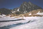
M&S, I've driven that route but only in September. I really liked it. The Burney Falls and Hat Creek area is pretty. The valley that you see (see photo) right before you hit Bridgeport is also neat. The June Lake loop road is a nice diversion as well as the short drive from Bishop up to Lake Sabrina. The one thing I remember is how cold it was in Bridgeport in September in the early morning. So cold that I had to get a tow truck out to jump my battery.
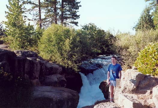 Hat Creek 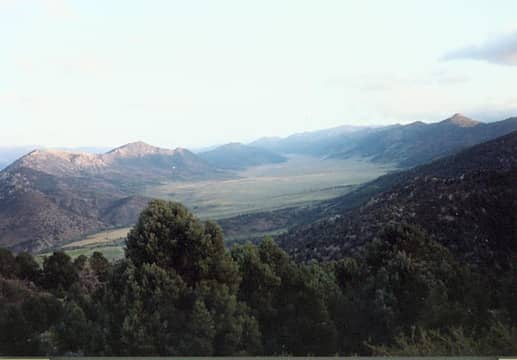 Near Bridgeport
|
| Back to top |
|
|
Smokey
Member
Joined: 10 Nov 2002
Posts: 792 | TRs | Pics
|
|
Smokey
Member
|
Sun Aug 03, 2003 8:03 pm |
|
|
M&S, you've just run into the Owens Valley chamber of commerce, I love that area. If you've got the time, then I would for sure avoid I-5. I'm most familiar with the area south of Mammoth.
You've seen Mono Lake? At Mammoth you could snowshoe or x-country ski, they have some marked routes. One closed road to Devil's Post Pile leads to a view point of the Ritter Range, beautiful. I've even made it down to the Post Pile itself in winter by another route.
The late Galen Rowell's studio is in Bishop. Sheepherder's bread at Schat's bakery. Good driving south of Bishop unless the snow is unusually low. The big Sierras to your west and the Whites to your east.
A photographer can't miss the Alabama Hills and Mt. Whitney at Lone Pine. Drive out into the Alabama Hills, you'll relive the old western movie days.
From Lone Pine head for Death Valley on 136 and past the Keeler Yacht Club. The finest dust in the world, it can penetrate a refrigerator seal. Hope the wind isn't blowing off Owens "Lake". The Owens Valley was swindled out of its water by Los Angeles. They are still pissed off about it.
Intersect 190 and head for Death Valley. Scotty's Castle is a worthwhile side trip I think. Quite a story behind it and a fun tour by the park service. Titus canyon is pretty spectacular, I've seen passenger cars do it. The sand dunes are in lots of photographs. Furnace Creek doesn't do much for me but that's where you can get gas and food.
If you go back out 190 you'll drop down into the Panamint Valley and can head towards Trona. There is a road/ trail to Panamint City. A strenuous little hike and I haven't been there since the road has developed waterfalls. But Panamint City is fun to spend the night at, ghosts for sure. I've hiked Wildrose Peak on Chrismas Day. Telescope Peak needs winter mountaineering gear that time of year. The trail for Wildrose leaves from the charcoal kilns, another interesting artifact.
Further on Trona has an odor not to be believed, the Trona pinnacles are an interesting thing. You can view petroglyphs on the Navy base in the middle of the desert if you schedule through the Ridgecrest museum.
Joshua Tree is famous for it's rock climbing, you can't possibly fall off that stuff. Beautiful area that time of the year too. The tram at Palm Springs is a tourist thing to do, but take some snowshoes and join in. You can outdistance most everybody in no time.
I'm done. Just let me know if I can cough up some more info. I'm thinking I'd better get back there and check up on it.
One last note, the wind. It blows cold that time of year. A pleasant day will turn frigid when the sun goes down and the wind can/will howl. Even in Death Valley.
|
| Back to top |
|
|
MooseAndSquirrel
Member
Joined: 10 Nov 2002
Posts: 2036 | TRs | Pics
|
Thanks you all for your comments - very much appreciated and duly absorbed! Nice pics, P. Bear. I should say I did do Hwy 108 over Sonora Pass (NW of Bridgeport) on one of my trips down there- that is an awesome drive as well- and it's closed in the winter for sure. I might just send you a PM sometime, Smokey, for more info about the area-thanks a lot. I've been to Mono Lake tufa display, Bodie Ghost Town (the best one I've ever seen-fantastic for photography), Ancient Bristlecone Pine forest in the White Mtns. , Whitney Portal, Alabama Hills, have read the history of how LA stole Owen Valley's water ( Mulholland & Co.'s doing) and one of my photo heroes was Galen. I'm pretty familiar with the area . I grew up in the East Bay, Santa Rosa and Redlands/LA area until moving up here with the family in '73. My family once rented a trailer and spent a long weekend at Joshua Tree in the late 60's when it was hardly a cactus-prick on the map. As a young teen there you couldn't help but want to climb on the rocks! Almost got stuck way up a diagonal crack on one rock face before getting up the courage to retrace my route down-sheesh I was scared. My dad and I thought it would be real neat to sleep under the stars on army cots and cotton sleeping bags the first night while the woman-folk slept in the heated trailer. It's the desert- warm at night-even in the early summer..... Middle of the night, freezing cold, Dad gave up and retreated in, followed by me not long after that. Wimps! You haven't lived 'til you've been to the Indio Date Festival and ridden a camel either. I don't have to go to Egypt to do that now. Believe it or not I never made it to Yosemite or the other places I mentioned before until after I moved up here!  Maybe some day I'll go up the Space Needle and hike near Mt. Rainier Maybe some day I'll go up the Space Needle and hike near Mt. Rainier  . Anyway, the only north/south routes I've driven in CA are I-5 and the Coast Highway 1- don't know anything about most of 395 and the northeastern CA roads. Thanks for enduring my life history.....good night. . Anyway, the only north/south routes I've driven in CA are I-5 and the Coast Highway 1- don't know anything about most of 395 and the northeastern CA roads. Thanks for enduring my life history.....good night.
|
| Back to top |
|
|
Malachai Constant
Member

Joined: 13 Jan 2002
Posts: 16092 | TRs | Pics
Location: Back Again Like A Bad Penny |
I lived in China Lake for two years. 395 is a good route chippies do not ticket for spending only DUI and reckless, as it should be. Death valley is great in winter - spring no one but batty Euros goes in Summer. great thins to see on ranges get a pass from visitor center, ghost towns etc. If you camp in desert bet to pack, if you know what I mean. Take water and gas, Trona is the model for Mordor in LTR.
"You do not laugh when you look at the mountains, or when you look at the sea." Lafcadio Hearn
"You do not laugh when you look at the mountains, or when you look at the sea." Lafcadio Hearn
|
| Back to top |
|
|
MooseAndSquirrel
Member
Joined: 10 Nov 2002
Posts: 2036 | TRs | Pics
|
| Malachai Constant wrote: | | I lived in China Lake for two years. 395 is a good route chippies do not ticket for spending only DUI and reckless, as it should be. Death valley is great in winter - spring no one but batty Euros goes in Summer. great thins to see on ranges get a pass from visitor center, ghost towns etc. If you camp in desert bet to pack, if you know what I mean. Take water and gas, Trona is the model for Mordor in LTR. |
I don't spend too much so I should do alright by the CHiPs If I camp in the desert (isn't the whole stinkin' region desert?) it will be at a campground and I don't pack heat if you catch my drift. Thanks for the info, Death Valley Days and the 20 mule team is definitely on my schedule.
|
| Back to top |
|
|
marta
wildflower maven

Joined: 07 May 2003
Posts: 1761 | TRs | Pics
|
|
marta
wildflower maven
|
Mon Aug 04, 2003 5:15 pm |
|
|
You can also go across Hwy 88 (Jackson Pass) from Sacramento through Jackson to Minden, NV and join up with 395 in Minden. That is usually kept open and is pretty good over the winter. It is excellent up to Kirkwood ski resort. The road from Minden down to Bishop on 395 isn't as heavily travelled and you do go over several good elevation passes (Conway Summit ~8500ft) on the way so it can require chains. I ususally only went as far as Big Pine so I'm not certain the rest of the way. We would drive from Stockton to Big Pine at Christmas and that was our normal route. Keep in mind, you'll be going over several passes > 7,000 ft in winter so expect chains and possible road closures.
I visited Joshua one March. It is great. I also highly recommend Anza Borrego. You might even catch some flowers late February.
|
| Back to top |
|
|
MooseAndSquirrel
Member
Joined: 10 Nov 2002
Posts: 2036 | TRs | Pics
|
Thanks Marta for that info. Sounds like I have to pick my poison as far as which route to take going south that will avoid the trickiest passes, slow-going, etc.! I've been over Conway Summit in summer & it's deceiving how high you get- very gradual straight grade me thinks. From what I understand from a friend the more northerly Hwy 89 & 44 leg from Shasta to 395 doesn't cross any or very few high passes, but he recommended me do it during daylight because it's a very lonely road at night and winds thru the mtns. in 2-lane fashion making it very tiring after a while. Without a doubt I'll be traveling in winter-driving mode w/ chains, etc. just in case. I'll add your route to ones I'm considering for sure, thanks again!
--M&S
|
| Back to top |
|
|
polarbear-
Guest
|
|
polarbear-
Guest
|
Mon Aug 04, 2003 10:35 pm |
|
|
The Gold(en?) Canyon day hike is also neat. Here are some photos I posted in another thread awhile back. On one trip I ended up going over Carson Pass, hwy 88 south of Sacramento and Placerville, because the other passes were closed or required chains. It was a beautiful drive, freezing cold at Silver Lake, where I could barely stand it long enough to take a couple pictures. This thread gives me a chance to post pictures of some places I really like.
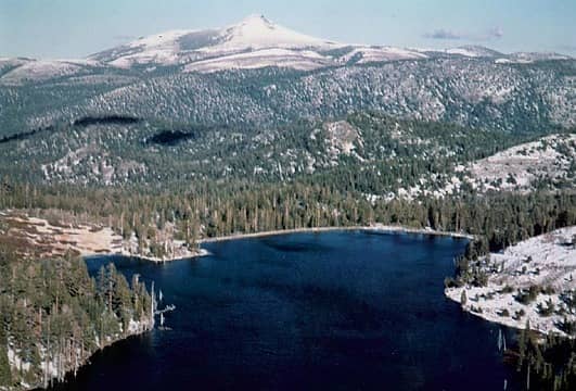 silver lake1 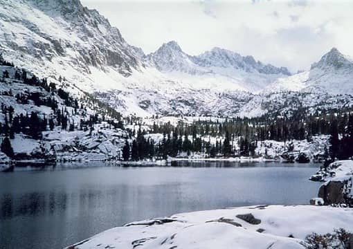 sabrina1
|
| Back to top |

|
|
polarbear-
Guest
|
|
polarbear-
Guest
|
Mon Aug 04, 2003 10:47 pm |
|
|
Oops the second picture might be Blue Lake up the trail from Sabrina. That's a good excuse to drive down there and get my captions straightened out.
|
| Back to top |
|
|
MooseAndSquirrel
Member
Joined: 10 Nov 2002
Posts: 2036 | TRs | Pics
|
PB, Golden Canyon is on the itinerary, thanks! Everything I've so far heard and read about Hwy 88 over Carson Pass says it's one of the most scenic trans-Sierra routes, and it doesn't get the traffic of 80 and 50. But I'd prefer to avoid the I-5 Sacramento Valley crappy boring drive to get to Hwy 88 and try something different (like Hwys 89-44-395 route)- I won't be in a super hurry to get down to Palm Springs/Death Valley/Joshua Tree and as long as that route isn't appreciably slower than I-5 and the southern Sierra crossings then I'm leaning toward it. But if I hear enough suggestions/warnings to try a better way then I'm all ears. My main focus is in seeing the desert areas in winter, and if I don't see snow up close that will be just fine I will be driving a low-slung Honda Civic down there and I realize that will keep me away from certain areas in Death Valley, etc. that a higher ground clearance vehicle would take me, but I'd rather not rent a jeep down there either. Anyway, keep those suggestions coming, thanks alot y'all! M&S
|
| Back to top |
|
|
|
|
You cannot post new topics in this forum
You cannot reply to topics in this forum
You cannot edit your posts in this forum
You cannot delete your posts in this forum
You cannot vote in polls in this forum
|
Disclosure: As an Amazon Associate NWHikers.net earns from qualifying purchases when you use our link(s). |


