| Previous :: Next Topic |
| Author |
Message |
Randy
Cube Rat


Joined: 18 Dec 2001
Posts: 2910 | TRs | Pics
Location: Near the Siamangs |
|
Randy
Cube Rat
|
 Tue Aug 05, 2003 10:43 pm |
|
|
This one has been at the top of my list for a couple of years now, so I was anxious to get started, so much so that I made it from Wallingford to the Beverly Creek trailhead in 105 minutes. You'd think I was speeding or something.
Stuck my truck in the empty parking lot and was on the trail promptly at 0700, right on schedule. The problem with the south route that I was taking today is that the first 6.9 miles (Green Trails mileage) only net me 500' of gain while I actually had to push out 1800' to get there, "what's up with this?" was a common thought en route to Ingalls Creek. Anyway, I ascended the Beverly Creek trail to 5200' where I turned right up trail 1226.1 which took me up to the 5600' pass and another intersection. I now went left on the Fourth Creek Trail and in roughly 3.6 miles this dropped me to Ingalls Creek at a depressing 4240'. Now only 4200' of steep, off-trail vertical separated me from Argonaut, needless to say this was somewhat unmotivating.
After a slick crossing (on rocks) of Ingalls Creek, I hurried up to the intersection with the Ingalls Creek Trail. Here instead of making things complicated I stepped over the trail and began my work up the hill. I had gotten a few good looks at the mountain while descending the Fourth Creek Trail, so I knew the basic objectives in piecing together a decent route to the top. After crossing the trail, the next 1700' were in trees as I ascended up and to the east. I aimed for the main watercourse/gully coming off Argonaut, but was careful to avoid getting to close to it until roughly 6000' as the lower reaches are choked with thick brush. I actually didn't enter the main gully until 6800'-6900'. Around this time I began noticing ominous weather moving at me from the south and what looked like heavy rain already hitting some of the southern Teanaway peaks - I was now racing weather to the top of Argonaut.
From about 6800' my route was in the main gully all the way up to the large south facing summit slabs at about 8200'. The gully is low-stress class 2 to about 7600' where I started getting into some fun class 3 slabs and slots that were entertaining for a couple hundred feet before even they got a bit tiresome. Once at the base of summit cliffs there is another gully of sorts (really a continuation of the main gully) that angles off to the east. This got me to within 80' of the east summit ridge before presenting a couple of options. Left was a class 4/5 route that looked doable and to the right was an easier looking slot with a potentially difficult final move. I went right finding it easy enough to manage and I got out of it by hooking one heal on a small horn and pulling myself up and around a couple of overhanging rocks.
Now on the summit ridge, the going was once again class 2 up to the final, leaning summit block. I ascended the final assortment of rocks from the east which was fun class 3/4 and an enjoyable way to complete the climb. Now 1200, the skies had gone from clear to dark-overcast in the time it took me to go from 6800' to the summit. One minute after summitting it began to rain, 5 minutes after summitting it began to thunder. Hooray for me! The thunder was enough to send me packing, so after signing the register and getting a few pictures, I was outa there. Back down the way I had come up the summit ridge. Before descending back to the main gully, I stole myself a couple of rappel slings I had seen along the way, tied them together, and used them to lower my pack down the more difficult sections in an attempt to aid the descent in wet conditions.
After working out a couple of the more difficult upper sections in the rain, I carefully descended the wet gully back down to 7000' where I finally took a break and ate lunch. Low and behold skies were now clearing up and the rain and any thunder were now non-existent. Still, even at 7000', the views were great from this rather unique vantage point. Great views of the Teanaway area and it was interesting and almost troubling to see just how far I had yet to go before I could call this one done! I descended the hill much the same way I ascended, but I did tend to err more to the west so as not to lose my key intersection along the Ingalls Creek Trail. Once back on the main trail, I walked east 200 yards before finding the Fourth Creek Trail which I took back across the creek to some of the gear I had stashed several hours earlier. A quick change of shoes and some more water and I set off up my last 1300' of the day. It would be another couple of hours before I was finally back at the trailhead at 1730. Good day, long route, but very fun mountain - no doubt a whole lot better than working.
|
| Back to top |
  
|
|
Allison
Feckless Swooner

Joined: 17 Dec 2001
Posts: 12287 | TRs | Pics
Location: putting on my Nikes before the comet comes |
|
Allison
Feckless Swooner
|
Tue Aug 05, 2003 11:00 pm |
|
|
So you had time to do Argonaut this week, but not enough to do revliS with me as originally planned?
Stinker!!
www.allisonoutside.com
follow me on Twitter! @AllisonLWoods
www.allisonoutside.com
follow me on Twitter! @AllisonLWoods
|
| Back to top |
|
|
Dayhike Mike
Bad MFKer
Joined: 02 Mar 2003
Posts: 10958 | TRs | Pics
Location: Going to Tukwila |
Man oh man...five hours from trailhead to the top of Argonaut? You are a climbing machine!
Argonaut's a beautiful peak...great views of it going up toward Stuart via Mountaineer Creek. I've always loved the slopes to the NW of Argonaut and Colchuck. Big old benches of talus, heather, and tamaracks.
How were the views of Stuart and Sherpa? Got any pictures of the arete coming off the backside of Dragontail?
"There is only one basic human right, the right to do as you damn well please. And with it comes the only basic human duty, the duty to take the consequences." -P.J. O'Rourke
"Ignorance is natural. Stupidity takes commitment." -Solomon Short
"There is only one basic human right, the right to do as you damn well please. And with it comes the only basic human duty, the duty to take the consequences." -P.J. O'Rourke
"Ignorance is natural. Stupidity takes commitment." -Solomon Short
|
| Back to top |
|
|
Randy
Cube Rat
Joined: 18 Dec 2001
Posts: 2910 | TRs | Pics
Location: Near the Siamangs |
|
Randy
Cube Rat
|
Wed Aug 06, 2003 5:01 pm |
|
|
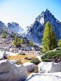
Here are some rather poor pictures I took in my rush to get off the mountain:
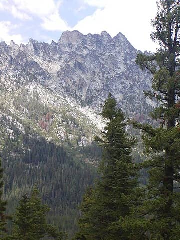 Argonaut 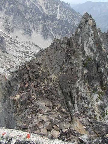 Ascent Route from East 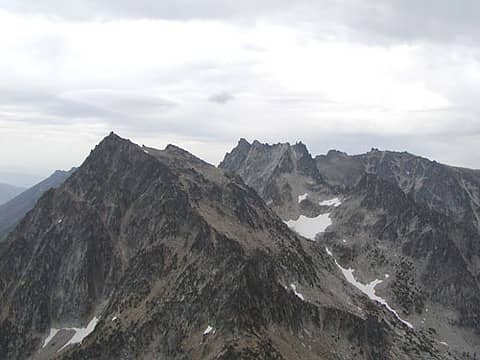 Colchuck, etc 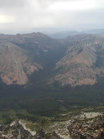 Ingalls and Fourth Creek Valleys 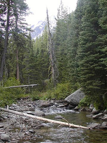 Ingalls Creek Crossing 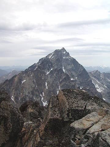 SherpaStuart 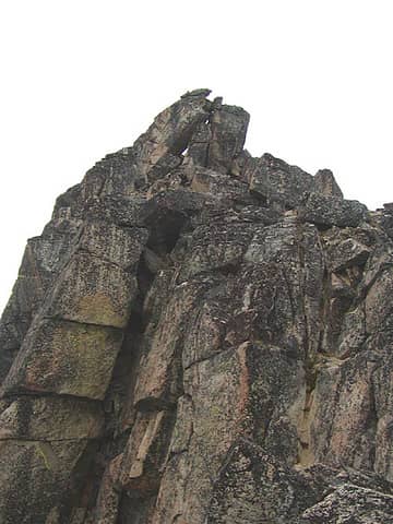 Summit Block
|
| Back to top |
|
|
|
|
You cannot post new topics in this forum
You cannot reply to topics in this forum
You cannot edit your posts in this forum
You cannot delete your posts in this forum
You cannot vote in polls in this forum
|
Disclosure: As an Amazon Associate NWHikers.net earns from qualifying purchases when you use our link(s). |


