| Previous :: Next Topic |
| Author |
Message |
Dayhike Mike
Bad MFKer

Joined: 02 Mar 2003
Posts: 10958 | TRs | Pics
Location: Going to Tukwila |
Tom, my dad, and I headed up the Middle Fork Road on Monday. As others have noted, the road seems especially bad this fall; the trip in took 2.5 hours.
We didn't get on the trail until close to 11am. Got into the talus slopes around 1:30pm. Decent views of Overcoat, Chimney Rock, and Summit Chief. Sun was high, air was hot, I cooked. Heat exhaustion set in shortly after arriving at Crawford and I managed to expel my lunch on the heather. Twice. Decided that we'd best be camping here even though the original plan had us staying at Azure. I managed to keep down a bit of dinner, slept well, and was ready to go again in the morning.
Tuesday morning, we headed over the ridge to view Chetwoot, Little Chetwoot, Angeline, Big Heart, and Azure. Traversed across lots of talus slopes and managed to get decent views of Azurite and Otter as well. Ascended to Iron Cap Lake and enjoyed its breathtaking beauty over lunch. Continued around and had a great time with the hefty traverse across to Iron Cap Pass. From here, Tom traversed down to Bonnie for more pictures while my dad and I proceeded up to south Tank Lake. Dropped pack and had a good time trekking north to north Tank Lake, Foehn, and Tahl. Tom had scrambled up from Bonnie by the time we returned and cold weather had blown in so we quickly ate dinner and crawled into bed.
Woke on Wednesday to find ourselves socked in by fog and cold wet mists, driven by unrelenting winds. Descended to the Necklace Valley past Foehn Lake and dropped packs at Opal for our tour of the Necklace lakes. Visited and had a good time enjoying the scenery around Jade, Emerald, Opal, Al, and Locket before calling it a day and heading south to the end of the valley. Had a good time scrambling up the wall at the south end of the valley. Looked down at Chain Lakes, had great views of Bear's Breast and then headed north to camp at the middle of La Bohn Lakes. Enjoyed a windy "final supper" of four trout (caught elsewhere during the course of the day) and pretty much all the other dinner items we'd brought in our pack. Slept well, feeling sated and full after a feast fit for a king. (Tom's a good cook.)
Thursday morning, Tom tried fishing the La Bohn lakes but didn't get any bites, my dad scrambled to the top of Mount Hinman and had a great time taking pictures (niiiiice!) with his new digicam, and I slept soundly in my warm bag / tent. Leisurely morning, finished up most of the breakfast items (see "feast fit for king" above) and then packed up and dropped down into the Chain Lakes. Sad to see all the devastation mining has wrought on these little jewels. The landscape is really torn up and littered with wreckage from the mining operation. From here, dropped down to Williams and had a good time wading. Tom took off and visited Dutch Miller Gap while my dad and I high-tailed it out for the truck. Left the parking lot at 6:15, made better time (only 2 hours!) down the rugged road, and managed to get into Scott's Dairy Freeze in North Bend before 9pm.
All in all a great time. World class terrain, some thrills, no spills, and a well-balanced trip in all respects. Stay tuned; pics to follow.
"There is only one basic human right, the right to do as you damn well please. And with it comes the only basic human duty, the duty to take the consequences." -P.J. O'Rourke
"Ignorance is natural. Stupidity takes commitment." -Solomon Short
"There is only one basic human right, the right to do as you damn well please. And with it comes the only basic human duty, the duty to take the consequences." -P.J. O'Rourke
"Ignorance is natural. Stupidity takes commitment." -Solomon Short
|
| Back to top |
  
|
|
Backpacker Joe
Blind Hiker

Joined: 16 Dec 2001
Posts: 23956 | TRs | Pics
Location: Cle Elum |
Mike you guys rock. That is a great trip. Dante and I are doing it this weekend. We are doing it in reverse. How was that traverse around from Crawford lake to Iron Cap pass?
TB
"If destruction be our lot we must ourselves be its author and finisher. As a nation of freemen we must live through all time or die by suicide."
Abraham Lincoln
"If destruction be our lot we must ourselves be its author and finisher. As a nation of freemen we must live through all time or die by suicide."
Abraham Lincoln
|
| Back to top |
|
|
Dante
Member

Joined: 16 Dec 2001
Posts: 2815 | TRs | Pics
|
|
Dante
Member
|
 Fri Aug 29, 2003 9:59 am |
|
|
Sounds like it's gonna be crowded in that general area.
BPJ and I made the trip in reverse a few years ago, but instead of following one of the routes from the Becky book around Iron Cap, we dropped to Otter and camped near the inlet. We did a lor of rafting on that trip courtesy of Mr. Curtis' fine raft.
I don't think we'll get over to the Gold Lake, Big Snow mountain area this time, but I love the that area.
|
| Back to top |
|
|
Tom
Admin
Joined: 15 Dec 2001
Posts: 17851 | TRs | Pics
|
|
Tom
Admin
|
Fri Aug 29, 2003 10:40 am |
|
|
The Iron Cap traverse is not bad. Not for newbies, but you guys should be able to figure it out. Beckey describes it accurately. BTW, Iron Cap Lake is completely thawed. Truly spectacular.
I brought my raft but never used it - didn't need it and didn't have time. I wouldn't do this route in less than 4 days. I was wishing we had an extra day. My biggest regret was not climbing Hinman.
|
| Back to top |
|
|
Backpacker Joe
Blind Hiker
Joined: 16 Dec 2001
Posts: 23956 | TRs | Pics
Location: Cle Elum |
Well, we only have Fri. night, sat sun and monday. I guess well have to RUN~!
TB
"If destruction be our lot we must ourselves be its author and finisher. As a nation of freemen we must live through all time or die by suicide."
Abraham Lincoln
"If destruction be our lot we must ourselves be its author and finisher. As a nation of freemen we must live through all time or die by suicide."
Abraham Lincoln
|
| Back to top |
|
|
Dante
Member
Joined: 16 Dec 2001
Posts: 2815 | TRs | Pics
|
|
Dante
Member
|
Fri Aug 29, 2003 1:46 pm |
|
|
| Backpacker Joe wrote: | | Well, we only have Fri. night, sat sun and monday. I guess well have to RUN~! |
Nah, Tom did more than we will probably do. Also, last time we did a version of this trip we camped at Williams, Otter and Gold IIRC. Three nights. I think we can make it to Williams tonight, with headlamps.
I can pass on the Necklace Valley, too. It will still be easy enough to get in there the traditional way after the FS gates teh MFK...
|
| Back to top |
|
|
Dayhike Mike
Bad MFKer

Joined: 02 Mar 2003
Posts: 10958 | TRs | Pics
Location: Going to Tukwila |
The route should be pretty obvious to you guys if you're doing it East to West...just make sure you start around 5450' from the ridge just west of Iron Cap Pass. Traverse pretty levelly, staying on top of the benches.
There's only one regrettable portion, a thick stand of dense scrub conifers. Aim diagonally up through this section and you'll be fine.
Coming from the West end, the only regret I have is that we went a little high at the beginning (~5650')...stay on the shelves right around 5500' and avoid gaining too much elevation. From there on, it was a kick in the pants and not too much trouble to routefind.
"There is only one basic human right, the right to do as you damn well please. And with it comes the only basic human duty, the duty to take the consequences." -P.J. O'Rourke
"Ignorance is natural. Stupidity takes commitment." -Solomon Short
"There is only one basic human right, the right to do as you damn well please. And with it comes the only basic human duty, the duty to take the consequences." -P.J. O'Rourke
"Ignorance is natural. Stupidity takes commitment." -Solomon Short
|
| Back to top |
|
|
Dayhike Mike
Bad MFKer

Joined: 02 Mar 2003
Posts: 10958 | TRs | Pics
Location: Going to Tukwila |
Making definite progress... Started with 977 images and I'm down to 398. Still more to cull.  Ne'ertheless, I've picked the best of the bunch to post for your pleasure.
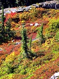
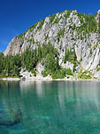
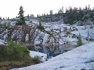
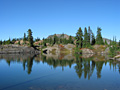
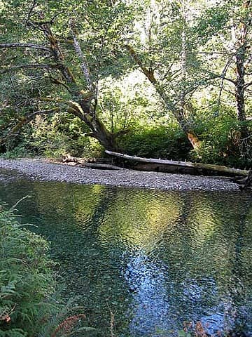 Middle Fork of the Snoqualmie River, somewhere above Dingford Creek. 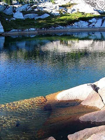 The tarn near our campsite, first night. 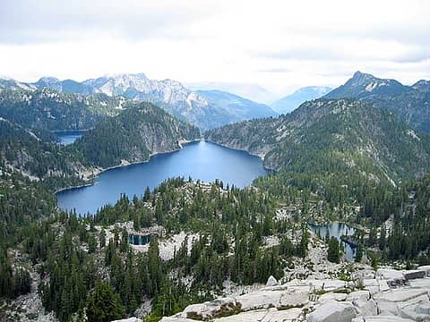 Big Heart, Angeline, Little Chetwoot, and Azure Lakes. 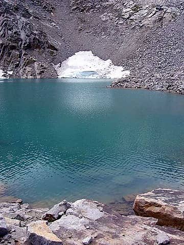 Iron Cap Lake from the east shore. 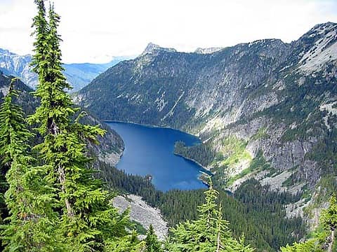 Otter Lake, during the traverse. 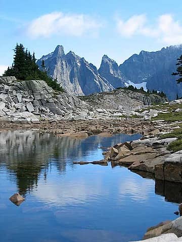 South Tank Lake, with Summit Chief in the background. 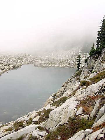 North Tank Lake, shrouded in mists. 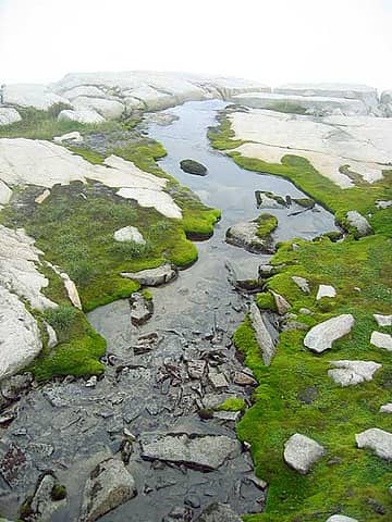 A shelf of moss on our descent to the Necklace Valley. 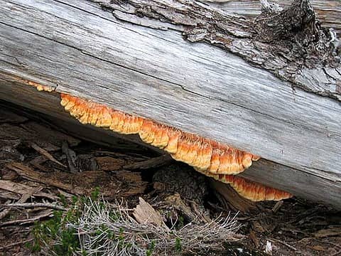 Fungal growth on a log above Opal Lake. 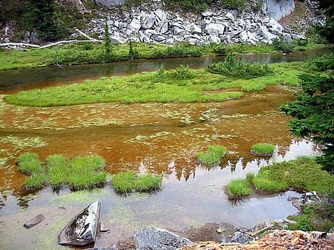 Sedge grasses on Emerald Lake. 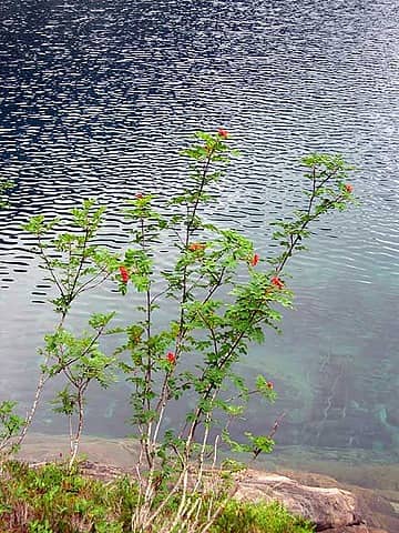 Mountain ash by Locket Lake. 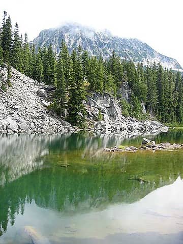 Far side of Al Lake. 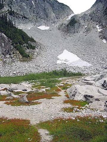 Our route, straight up and out of the Necklace Valley. 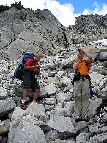 My dad checks the map as Tom composes an image, just before we start up the cliffs. 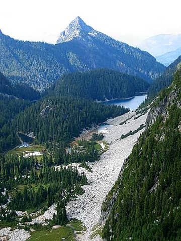 The Necklace Valley below. Opal, Cloudy, and Ilswoot are most apparent. 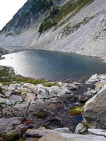 The northern two La Bohn Lakes. 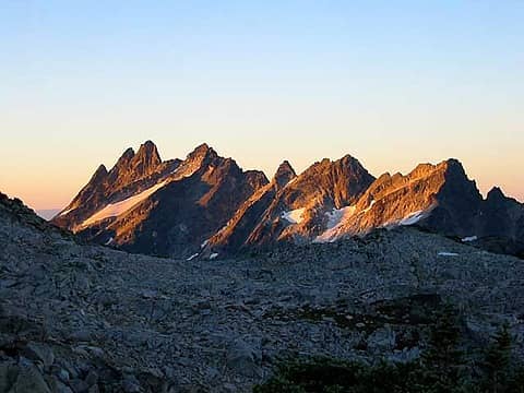 Alpenglow on Bears Breast mountain. West ridge of Hinman in foreground. 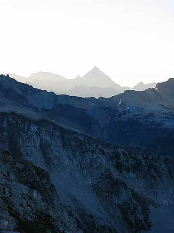 Looking across to the East ridge 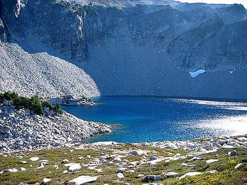 The southernmost of La Bohn Lakes. 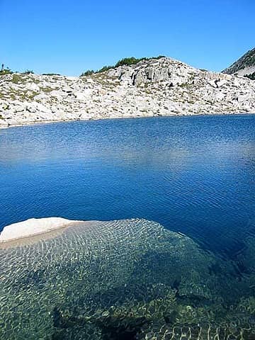 Tarn near La Bohn Lakes. 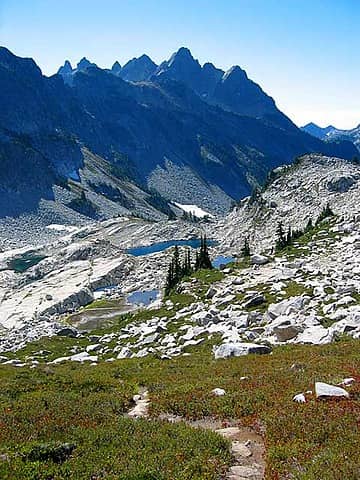 Dropping down to the Chain Lakes. 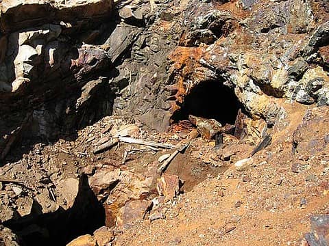 Abandoned mine shafts and equipment at Chain Lakes. 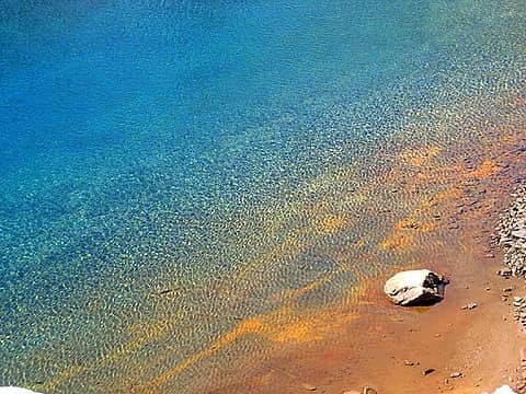 Tainted sand makes for a colorful shore. 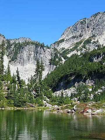 Wading in Williams, looking up toward Chain Lakes. 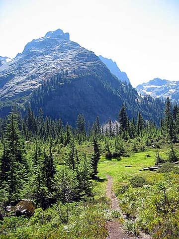 Heading home from Williams Lake, Summit Chief in the background.
"There is only one basic human right, the right to do as you damn well please. And with it comes the only basic human duty, the duty to take the consequences." -P.J. O'Rourke
"Ignorance is natural. Stupidity takes commitment." -Solomon Short
"There is only one basic human right, the right to do as you damn well please. And with it comes the only basic human duty, the duty to take the consequences." -P.J. O'Rourke
"Ignorance is natural. Stupidity takes commitment." -Solomon Short
|
| Back to top |
|
|
Odonata
Member

Joined: 14 Aug 2002
Posts: 306 | TRs | Pics
|
|
Odonata
Member
|
Sat Aug 30, 2003 8:13 am |
|
|
|
| Back to top |
|
|
Captain Trips
Member

Joined: 06 Mar 2002
Posts: 437 | TRs | Pics
|
You guy's are too cool, helpful too!
I'm going up the same area on Monday so I appreciate those pictures especially so.
DROCK
|
| Back to top |
|
|
Allison
Feckless Swooner

Joined: 17 Dec 2001
Posts: 12287 | TRs | Pics
Location: putting on my Nikes before the comet comes |
|
Allison
Feckless Swooner
|
Mon Sep 01, 2003 11:37 pm |
|
|
R and I were at the other end at the stuff around Gold these past few days. Rugged country, incredible scenery, fun stuff. Amazing link-up to do the Beckey ALW High Route, I'd be proud to do the whole thing sometime.  The stuff in the neighborhood of Gold is so pristine, it blows my mind. The stuff in the neighborhood of Gold is so pristine, it blows my mind.  Getting in via Dorothy is a massive amount of work. Next time I'm in the neighborhood it will be via another route.
Anyone know if there is a way trail up Camp Robber Valley? There is the beginning of a trail from the confluence at Miller and Camp Robber Creek but I have no idea if it goes.
Fun weekend, I'l try to post a pic or two later.
Getting in via Dorothy is a massive amount of work. Next time I'm in the neighborhood it will be via another route.
Anyone know if there is a way trail up Camp Robber Valley? There is the beginning of a trail from the confluence at Miller and Camp Robber Creek but I have no idea if it goes.
Fun weekend, I'l try to post a pic or two later.
www.allisonoutside.com
follow me on Twitter! @AllisonLWoods
www.allisonoutside.com
follow me on Twitter! @AllisonLWoods
|
| Back to top |
|
|
Dayhike Mike
Bad MFKer
Joined: 02 Mar 2003
Posts: 10958 | TRs | Pics
Location: Going to Tukwila |
Yep...that's a pretty nasty bushwhack up that valley. Starts nice (from Dorothy) and ends nice (the ascent to Gold Lake) but in between the route fades in and out at will.
After you crossed the river for the first time and headed up to the final hanging valley, which side of the river were you on up until the final ascent to Gold? Beckey indicates it's on the west side of the creek and so we crashed through brush watching for some indication of better trail, but I could have sworn I saw good walking on the other side of the river -- almost a path at spots. Can you verify or deny?
How were the tarns on the shoulder of Wild Goat Peak, near the pass between Gold Lake and Camp Robber Valley? They were frozen over when we tromped through there last. I've wondered if there might be a route from these tarns down to the valley floor (past 4225), as we found a nice, albeit faint path up past the pond NW of 4225 and the route along the valley floor began to disintegrate around here.
As for Camp Robber Valley, there's got to be a path even though Beckey doesn't indicate one on his maps. I've seen the boot trail heading off from the Confluence as well, and that valley looks way too inviting for the fishermen to have abandoned it entirely. Another option I've considered / looked for is a route from the north end of Dorothy into Charlie Lakes, which might then lead into the draw of the Camp Robber Valley.
Anyway, I agree it's beautiful and rugged country, and that I as well will not likely be doing the bushwhack from Dorothy to Gold ever again. Going in over Big Snow Mountain this coming weekend and am looking forward to seeing Gold again.
"There is only one basic human right, the right to do as you damn well please. And with it comes the only basic human duty, the duty to take the consequences." -P.J. O'Rourke
"Ignorance is natural. Stupidity takes commitment." -Solomon Short
"There is only one basic human right, the right to do as you damn well please. And with it comes the only basic human duty, the duty to take the consequences." -P.J. O'Rourke
"Ignorance is natural. Stupidity takes commitment." -Solomon Short
|
| Back to top |
|
|
Allison
Feckless Swooner
Joined: 17 Dec 2001
Posts: 12287 | TRs | Pics
Location: putting on my Nikes before the comet comes |
|
Allison
Feckless Swooner
|
Tue Sep 02, 2003 8:42 am |
|
|
| Dayhike Mike wrote: | | Yep...that's a pretty nasty bushwhack up that valley. Starts nice (from Dorothy) and ends nice (the ascent to Gold Lake) but in between the route fades in and out at will. |
That is an understatement! Sometimes we got tired of even looking for it and just forced our way through. I have the bruises to prove it.
| Quote: | | After you crossed the river for the first time and headed up to the final hanging valley, which side of the river were you on up until the final ascent to Gold? Beckey indicates it's on the west side of the creek and so we crashed through brush watching for some indication of better trail, but I could have sworn I saw good walking on the other side of the river -- almost a path at spots. Can you verify or deny? |
There are two outfalls to Gold. The main one with all of the logs in it, and a smaller one to the west (it's really south) of the main one. It drains out of the first big tarn you get to. We were west/south of this second outfall and it was not too bad, there is in fact a path going through that section. "Hanging valley" har de har that is a good one. I'd call that "really steep-ass hill"!!!
| Quote: | | How were the tarns on the shoulder of Wild Goat Peak, near the pass between Gold Lake and Camp Robber Valley? They were frozen over when we tromped through there last. I've wondered if there might be a route from these tarns down to the valley floor (past 4225), as we found a nice, albeit faint path up past the pond NW of 4225 and the route along the valley floor began to disintegrate around here. |
I'll have to post a picture to do those tarns justice.
| Quote: | | As for Camp Robber Valley, there's got to be a path even though Beckey doesn't indicate one on his maps. I've seen the boot trail heading off from the Confluence as well, and that valley looks way too inviting for the fishermen to have abandoned it entirely. Another option I've considered / looked for is a route from the north end of Dorothy into Charlie Lakes, which might then lead into the draw of the Camp Robber Valley. |
Yeah, that could work too.
www.allisonoutside.com
follow me on Twitter! @AllisonLWoods
www.allisonoutside.com
follow me on Twitter! @AllisonLWoods
|
| Back to top |
|
|
Allison
Feckless Swooner
Joined: 17 Dec 2001
Posts: 12287 | TRs | Pics
Location: putting on my Nikes before the comet comes |
|
Allison
Feckless Swooner
|
Tue Sep 02, 2003 9:48 am |
|
|
I can't imagine why anyone would want to go to this godforsaken place.
 tarn
www.allisonoutside.com
follow me on Twitter! @AllisonLWoods
www.allisonoutside.com
follow me on Twitter! @AllisonLWoods
|
| Back to top |
|
|
Tom
Admin
Joined: 15 Dec 2001
Posts: 17851 | TRs | Pics
|
|
Tom
Admin
|
Tue Sep 02, 2003 10:21 am |
|
|
Don't sugarcoat it. This one didn't have a pretty bathtub ring like all the others.
|
| Back to top |
|
|
|
|
You cannot post new topics in this forum
You cannot reply to topics in this forum
You cannot edit your posts in this forum
You cannot delete your posts in this forum
You cannot vote in polls in this forum
|
Disclosure: As an Amazon Associate NWHikers.net earns from qualifying purchases when you use our link(s). |


