| Previous :: Next Topic |
| Author |
Message |
JimK
Member


Joined: 07 Feb 2002
Posts: 5606 | TRs | Pics
Location: Ballard |
|
JimK
Member
|
 Sun Sep 21, 2003 5:22 pm |
|
|
I had scrambled up Vesper Peak one time before. It was in October following the record snow year of, I believe, 1998. The upper mountain was under 4-6 inches of fresh snow on top of several feet of ice from the previous winter. I had hoped to hike up the great rock slabs and instead had a winter like climb. Since then I had meant to do a late season trip and finally see the mountain without ice and snow. This was a mountaineer trip with Karen leading so I was sure it would be a fun day. We were the first hikers to arrive at the trailhead and were on the trail by 9:10. I expected the creek crossings to be very easy since the summer has been so dry. There was a little rain the last week and surprisingly the creeks had a substantial flow. They were still easy enough to rock hop across. The final crossing is the S F Stillaguamish and that would have been a big problem except for a log across. It is not very wide but the top has been cut flat. It was not there on my previous trip and made for a much better crossing than we had then. Soon the forest gives way to more open terrain and some views begin. Sperry Peak is high above and Mt. Dickerman is across the valley to the north. Fall colors are just beginning. This will be even more impressive in a few weeks. The group came back together at the river crossing. We planned to do the same when we reached the beginning of the upper valley. The trail makes a number of switchbacks as it climbs up into the valley. This is an old miners trail and is definitely not up to modern standards. Still it is better than most miners trails I have been on.
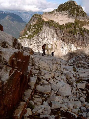
When we entered the upper basin we stopped to wait for the others. From here we could see up towards Morningstar Peak and to the vicinity of Hedlee Pass. The actual pass is not visible until you are directly below it. Karen was with the latter half of the group and they took a side trail which took them across the valley. We soon spotted them and the group came back together. I missed out on their little scrambly adventure. The trail is nearly nonexistent in places as the dirt gives way to talus. There are cairns periodically to keep you on the correct route. Most of the way from here to the lake is on rock. It can be more than a little jarring on the knees, especially on the descent. Higher up the valley the trail is much more obvious and some is even on dirt. When the trail finally switchbacks this is the signal that the climb to Hedlee Pass has begun in earnest. The gully narrows and so do the switchbacks. The grade is not too steep but there are many switchbacks. Hedlee Pass is small and forested. A short trail leads to views out towards Mt. Pugh. On the other side Vesper Peak came into view for the first time. There were a few clouds as we hiked from the start to the pass. I was surprised to see that on the other side of the pass it was mostly cloudy. The clouds were very low. Vesper went from hidden to visible as the clouds blew through. We had agreed to reform the group near the lake so we had the OK to proceed to there. From the pass the grade drops slightly and traverses across a long talus field. Across the rocks is the creek coming from the lake between Vesper and Sperry Peaks. I have heard this lake called "Vesper Lake" and "Elan Lake". Whichever, it is completely surrounded by rocks and still has snow along several sections of the shoreline. An iceberg island is floating in it as well. We dropped our packs where the climbers trail begins to ascend Vesper and hiked the short distance to the lake. A lake this barren seems out of place this low and this far west of the crest.
After returning to our packs and having lunch the rest of the party arrived. We bundled up while waiting as it was getting cold. From here to the summit tuned out to be some of the most enjoyable scrambling I have done. It was much different, more interesting, and safer than the icy trek I had done before. The route is at first through heather with some trees. It then steepens considerably but is still just a trail. The vegetation soon ends and there was nothing but bare rock between us and the summit. We followed cairns part of the way but they are really not necessary. Most any route will do if you just aim a little to the left of the summit. This rock had as much traction as anything I have ever been on. It might be a little tougher if wet but it was dry today. We purposely tried to find some slightly more challenging spots to make it more interesting. In no time we were on the summit. I expected it to take more than 30 minutes to gain the 1300' from the creek to the summit. Clouds were all around us. They blocked many of the views. On the positive side it was sunny directly above us and we were comfortably warm. The tip of Glacier Peak periodically poked its head above the clouds. Nearby Big Four never did. The clouds were especially bad to the south and west. One other hiker was on top. Her climbing friends had rappelled down to climb the very challenging north face. We later met them and after descending they were unable to cross a huge moat and didn't get to do their climb. Karen wasn't sure she felt well enough to make the summit but make it she did. This is a popular place. The summit register is two years old and it is already full.
Photography from the summit was a little frustrating. Peaks would come out of the clouds for a few seconds then be plunged back out of sight. The clouds did make for some very interesting photos as well. The descent of the rocks was as much fun as the climb. Once I had confidence in the traction I was able to walk down sections which seemed way too steep. After the rocks came the heather slopes and soon we were back at the creek. The rest of the descent was straight forward but slow as a few people were having leg and knee problems. We still made it out comfortably before dark. This turned out to be a fun trip. The slabs of Vesper were even better than I had hoped for. The company was A+ and the weather was not great but it never rained. I'm sure I will be back to Vesper on a more or less regular basis. The distance listed on maps and books seem to conflict for this trip. I estimate that it was about 8 miles round trip with 4200' gained.
Photos are here: Vesper Photos
|
| Back to top |
  
|
|
Karen
Member

Joined: 22 Dec 2001
Posts: 2866 | TRs | Pics
|
|
Karen
Member
|
Sun Sep 21, 2003 6:25 pm |
|
|
Vesper Peak
The trail to the mountains
Begins in the heart
Where the wild paths
Tangle and
Marriages begin
And end
Birds we cannot see
Sing
In the shadows
And pikas run across
The rocks
Beneath a cedar tree
That has withstood a thousand
Storms
The trail gets worse each
Year
The crumbing bridge
Now missing planks
And rotten around the edges
A slimy glaze of leaves and darkness
The first half mile
Weaves
Through trees and
Vegetation
That never sees the light of sun
To the Stillaguamish River
Each year
The footlog
More treacherous
Than the year
Before
Every year the route
Through the valley
Is cairned anew and
You cannot see Headlee Pass
Until you work your way
Up the valley
Thus I was fooled by a liars path
Marked with a cairn
Off route
Leading to nightmare slabs
And a lunatic path
That dies in brush and ancient snow
But the mountains gave
Me back again
To meet others
On the trail
Lets meet at the lake,
Someone says
And someone else
Says
If I dont get there
Go on without me
We climb together
And we break apart
But everyone gets there
Some of the climbers are fast
Climbing the golden slabs
Reading the alphabet of footholds
Others are slower
But not defeated by bad knees
Though we take different paths
We arrive at the same place
And gather on the summit
Copper Lake
Lies like a legend below
A scrawl in the summit register
Says you were there
A long time ago
We tried to keep the summer
And hold it still
But it is September after all
And pikas are scurrying across
The broken slopes
Of Sperry Peak
Does anyone see
Those fragile harebells
Clinging to the cliff
Does anyone see
That last stand of gentians
Against the fading light
But we must hurry now
To beat the dark
And cannot linger to
Taste the cold, sweet berries
Along the trail
We must follow the path
Past the dark mirror
Of the pond
That earlier clasped the sun
And cross the river
Once more
Armed against the oncoming night
With feeble flashlights
And corny jokes,
Tired but laughing
All the way back
Karen Sykes
9-20-03
stay together, learn the flowers, go light - from Turtle Island, Gary Snyder
stay together, learn the flowers, go light - from Turtle Island, Gary Snyder
|
| Back to top |
|
|
Karen
Member
Joined: 22 Dec 2001
Posts: 2866 | TRs | Pics
|
|
Karen
Member
|
Sun Sep 21, 2003 7:28 pm One photo
|
|
|
Well, Jim's photos are really gorgeous but here's one of mine you might enjoy too!
Karen
 Descending Vesper
stay together, learn the flowers, go light - from Turtle Island, Gary Snyder
stay together, learn the flowers, go light - from Turtle Island, Gary Snyder
|
| Back to top |
|
|
jenjen
Moderatrix

Joined: 30 Jun 2003
Posts: 7617 | TRs | Pics
Location: Sierra stylin |
|
jenjen
Moderatrix
|
Sun Sep 21, 2003 8:54 pm |
|
|
Wow, Karen, that poem is just lovely.
If life gives you melons - you might be dyslexic
If life gives you melons - you might be dyslexic
|
| Back to top |
|
|
Dogpatch
Member

Joined: 17 Aug 2003
Posts: 1588 | TRs | Pics
Location: the dryside |
|
Dogpatch
Member
|
Mon Sep 22, 2003 9:39 am |
|
|
Jim and Karen,
Thanks for the great reports and pictures. I'm planning on heading up to Headlee Pass for the first time this week, so your accounts were a real treat to see.
I've been reading other trail reports, and am encountering a bit of confusion as to where the trail goes when it hits the basin below Headlee Pass. Some people say to cross over to the right side of the basin--others stay on the left.
I'm not a super-experienced hiker, so I'd appreciate any route advice anyone has for me.
Gotta get up there!
"Outside of a dog, a book is man's best friend.
Inside of a dog, it's too dark to read." Groucho Marx
"Outside of a dog, a book is man's best friend.
Inside of a dog, it's too dark to read." Groucho Marx
|
| Back to top |
|
|
JimK
Member
Joined: 07 Feb 2002
Posts: 5606 | TRs | Pics
Location: Ballard |
|
JimK
Member
|
Mon Sep 22, 2003 9:48 am |
|
|
Dogpatch,
Stay on the most obvious route and you will be fine. If you lose the way on a rock field look ahead for a rock cairn. They are pretty big. Of course if you want a little adventure, ask Karen about a route to the right side of the basin. She managed to have a bit more of an adventure than I did.
|
| Back to top |
|
|
Captain Trips
Member

Joined: 06 Mar 2002
Posts: 437 | TRs | Pics
|
Jim,
Good looking group on the summit, a great group pose that seems very fresh and unfettered with the usual sweat and sore muscles.
What camera did you use ?
Drock
|
| Back to top |
|
|
JimK
Member
Joined: 07 Feb 2002
Posts: 5606 | TRs | Pics
Location: Ballard |
|
JimK
Member
|
Mon Sep 22, 2003 10:16 am |
|
|
Sweat?? Sore Muscles?? Gee, it was only 4100' up a rocky old miners trail.
I am another of the many Canon digital users on this site. Mine is the s45.
|
| Back to top |
|
|
Dogpatch
Member
Joined: 17 Aug 2003
Posts: 1588 | TRs | Pics
Location: the dryside |
|
Dogpatch
Member
|
Thu Sep 25, 2003 9:25 am |
|
|
| JimK wrote: | | Stay on the most obvious route and you will be fine. |
Jim,
Thanks for the advice/encouragement. Me and my pal and our dog made our first hike to Headlee Pass, and it was just beautiful. Went a ways over the pass, and spotted the adits of the old Sunrise Mine.
Packed in a bunch of ancient cameras, and spent a lot of time in the gully going up to the pass. What a great place! We'll be back.
"Outside of a dog, a book is man's best friend.
Inside of a dog, it's too dark to read." Groucho Marx
"Outside of a dog, a book is man's best friend.
Inside of a dog, it's too dark to read." Groucho Marx
|
| Back to top |
|
|
|
|
You cannot post new topics in this forum
You cannot reply to topics in this forum
You cannot edit your posts in this forum
You cannot delete your posts in this forum
You cannot vote in polls in this forum
|
Disclosure: As an Amazon Associate NWHikers.net earns from qualifying purchases when you use our link(s). |


