| Previous :: Next Topic |
| Author |
Message |
ridgewalker
Mountains and Rivers


Joined: 19 Aug 2003
Posts: 223 | TRs | Pics
Location: North Bend |
|
ridgewalker
Mountains and Rivers
|
 Mon Feb 09, 2004 8:18 pm |
|
|
Name - Tiger Mountain Trail (TMT) aka (Trail Mauled by Trees!)
Area - Tiger Mountain State Forest
Hike - 15 miles (TMT) 17 miles total hiked
Type - Lowland Stomp
Ecology - Temperate Fir & A Deciduous Mixed Second Growth
Geology - Lowland Moraine & Uptrust
We woke up early in the morning. To get that start that we thought we needed. It was going to be a epic day, the Tiger Mountain Trail from South to North! Robin woke Josh and I up at about 5:20 AM and we were out searching for the trailhead around 6:10 AM. It took sometime but ended up finding the trail. Future note - the trail is about .3 miles up the road across from a pull out with a No Dumbing sign. No real signs but a road way flap that state Horse and Hiker signs. We set out down the dark trail, dawn had yet to come to this land. It followed in and around some swamps then started to ascend the side hill. About this time, I turned off my headlamp in order to let the ambient light soak in and light up the trail. Only a few times did I need to actually turn the lap back on. The mist was dominant. Setting the tone of s erie trail into some far off swamp. By the time light began to break we could hear the crows making a ruckus. It was here that Josh pointed out that a group of crows was called a Murder. I am not sure about this, but by their sounds, I could only imagine being a mid-evil farmer and walking into such a woods. I would think murder was in the air too. As we went on we could tell that thinning had taken place in this south end of the Tiger Mountain State Forest. A clear and present reality, that while the North in is saved from the saw, this south end is as the signs point out, a "working forest." From it seemed the alders began to dominate, as their lust for cleared lands and the abundant water choked the skies from the small seedling cedars and douglas firs. It should be noted that there is some need for signage on this south end of the trail. Hopefully, by the end of next weekend, I should have remedied this situation with some clear placed TMT signs. The reason for this is some new roads before the intersection with the South Tiger Traverse. And some access trails back to Hwy 18.
After passing a road that heads all the way back to Tiger Summit on Hwy 18, there was a distinct change in forest type. The green was dominant. The douglas fir and cedar mix had begun to dominate the land scape. The trail also began to make it's rise towards Middle Tiger Mountain. Fungus dominated the interest here. Many different types on trees, along the ground, everywhere. Soon my interest caught up to me, as I began turning over rocks that looked like the tan white of a fungus, in trying to figure out if it was a Ascomycete or Basidiomycete. But our trail had more in-store for us. As we began to get closer to the ridge line the one thing that would dominate the rest of the trail began to happen, blow downs. Now I have hiked trails, where there were a few blow downs, that you had to go over. There was always a sense of skill and accomplishment when closing such obstacles. Yet here on the TMT, it was quite a different story. We entered a zone where for acres the trail was blocked by blow downs. It seemed the objective that the trail was to be covered by an entangled mess. After about an hour of trying to go through and around these knots of wood, Josh and I believed we were quite off trail. Pulling out the map, and trying to determine if the tread we saw was from a former creek bed or the trail, we noticed a sign, TMT - 5. This ment that we were still on the trail, and 5 miles in at that. It was a relief, otherwise the amount of time re-finding the trail might take way from out goal of making the end of the trail before night fall. We did have headlamps and were prepared for such a journey, but there is always that joy to know that you don't have to go on hiking when the sun falls below the horizon.
As we rounded the trail on the west side of Middle Tiger, we caught ourself going up hill, it was a while before I asked Josh for the map, and released that we were again off the TMT. There had been a crossing and we missed it. Hiking note - When you come to the 4 way fork of the TMT and the Middle Tiger Trail. Stand long till you see all three trails, this will help you not make the mistake we did. To keep the same contour on the ridge is the right choice. The trail down the mountain is not as noticeable as it would seem. After that there were a few blow downs that choose to fall linearly along the trail, thus off trail was necessary. Coming around the bend we saw two Trail Runners. They were to say the least, hacked by Blow downs yet to come. We passed greetings to them and gave the tip that the Middle Tiger Trail down would be a better choice. We round the bend, and again off trail! Down the Hobart Grade, the TMT was not marked as well as we had hoped. So we took the other trail, which turned out to be another mine field of blow downs. Here Surveyors' tape almost took us off course again. I have determined that surveyors' tape is not a required 14th essential when hiking. If I can help the next guy through the mess of trees, the better. It seemed that this was what the other tape was doing, yet we found a better way.
At this point the trail lost a lot of the blow downs. Now the trip would be a different experience. The rain began to pour pretty well, and took a break. Here the trail is interesting. It changes forest types many times. There is a dense thicket of planted Douglas First that hold in the mists. One can only imagine, following the trail as the mist builds and the darkness soaks in. Next thing you know you are taken to the realm of the Lord of the Rings, and Orcs are charging down this hill at you. Yet in the distance you can see the light of a section of alder. Maybe this is why alder and oak stands in celtic Britain are considered sacred. In and out. The effect was not just in light and mist, but sound and temperature. The forest changed 3 times like this. Right after one of these changes Josh and I were speculating on the tails of old spirits caught in a forest, when around the corner came another trail runner. This time it was a lone asian women in shorts, listening to her music. I think both of us, dressed in black, dirty with heavy packs, long hair and facial hair, took here a little off guard. Would have offered the Middle Tiger Suggestion, but she was gone in a flash, into the dark forest. Could only imagine what she thought. But on we went.
The trail had a few more crossings, I would tell you what they were but I am at a food court and have no map to look it up on.  It seems to me that everyone who ever walked this trail has a sign on it. The one that boggled us was "High Lead Cable." I could only imagine, this was a warning not to chew on the cables that surrounded us due to the Lead value. I know at this point not packing enough power bars, this was on my mind. heh heh! There was a large crossing of a creek by a bridge. It was right before the jct. with Fifteen Mile Ridge Trail. Around the creek was a dense thicket of Devils Club and Salmonberry brush. All of the foliage had been lost for the winter, and was a perfect look to think about biologic scale. We as hikers tend to look up at the trees. It is natural, they are bigger then us and have a sense of awe. Yet here is another awe sight. To think on the scale of insects. The scale of the large Devils club towering like space stations over the creek. It is always worth a moment to stand by these creeks and take yourself to that scale. It is a unique look into the world, that many of us inhabit.
Along the trail to come while finally rounding the North Tiger section, the snow began to fall. It was not much, but a definite temperature change from earlier. The trail here is much more defined. No thrills, this is just the TMT, trekking it's way from one end to another. A network of other trails promised grand views, yet our journey was to hike the whole length of this one trail. We gained our first view, just before the jct. with the West Tiger 2 and 3 Trail. All we could see was a silhouette of the tops of fir trees surrounded by mist. It was the classic view for the day! Coming over the ridge, the forest gain changed from the small firs and alders to a ground stand of uniform firs. You could see the holes in the forest canopy where the snow fell and formed patches. One spot was in a hole in the side of the mountain where there was a lone tree covered by white snow. Almost as striking as a christmas tree with lights on it. I had to take a picture of it! The dark background seemed to highlight to falling power surrounding that one tree. It was another home to some mountain spirit.
Once we came over we met up with the familiar stomping grounds of North Tiger section of the TMT. A sense that we were almost there, the end. Going down the trail, I met up with an old man caring a crosscut saw. He said he had been working on the trail for the last two months, logging out 19 days worth of trail. It was uplifting to see this man out there. He was with no organization, just a deep sense of duty to pay back to what he loved. It was a motivation. I asked him about his crosscut saw, which was tempered steel. It has inspired me to take up a saw, pulaski and brush bar and head out to a trail in need. So many miles logged on trails, but one had to put into upkeep, especially this year, or least the effects of the great storm will kill our favorite haunts. Now I am not advocating that all trails should be maintained. No some should be left for wilderness to take back. To allow the forces of nature to wipe clean the marks of humanity. But those that we all use should be maintained so others can learn from their own forest experience.
The last bit of the TMT, followed down towards the lingering loop. Here we saw were the man had cut out the blow downs, and crossed into one of the grandest fern gully's I have seen. Coming over the ridge, all I could see was a bowl of green. The firs stood random and sparse, yet kept a full canopy. On the ground Ferns, everywhere! There was not a piece of ground that was not covered by the rich green of the sword fern. It was something to stop and soak in. To let the eyes become inundated with this one color. Sword ferns always have a contrasting edge. It is something that makes the view pop out at you.
We followed the trail out to the Parking Lot at the High Point. It was a long hike. We still had 2 miles to go to the 271 Metro Bus on Front Street in Issaquah. All in all a great and tiring experience. Major attention needs to be attended to the South End. Once that is done, I would suggest a South to North Hike for any who want to get in the experience of this State Forest.
-- Ridgewalker It seems to me that everyone who ever walked this trail has a sign on it. The one that boggled us was "High Lead Cable." I could only imagine, this was a warning not to chew on the cables that surrounded us due to the Lead value. I know at this point not packing enough power bars, this was on my mind. heh heh! There was a large crossing of a creek by a bridge. It was right before the jct. with Fifteen Mile Ridge Trail. Around the creek was a dense thicket of Devils Club and Salmonberry brush. All of the foliage had been lost for the winter, and was a perfect look to think about biologic scale. We as hikers tend to look up at the trees. It is natural, they are bigger then us and have a sense of awe. Yet here is another awe sight. To think on the scale of insects. The scale of the large Devils club towering like space stations over the creek. It is always worth a moment to stand by these creeks and take yourself to that scale. It is a unique look into the world, that many of us inhabit.
Along the trail to come while finally rounding the North Tiger section, the snow began to fall. It was not much, but a definite temperature change from earlier. The trail here is much more defined. No thrills, this is just the TMT, trekking it's way from one end to another. A network of other trails promised grand views, yet our journey was to hike the whole length of this one trail. We gained our first view, just before the jct. with the West Tiger 2 and 3 Trail. All we could see was a silhouette of the tops of fir trees surrounded by mist. It was the classic view for the day! Coming over the ridge, the forest gain changed from the small firs and alders to a ground stand of uniform firs. You could see the holes in the forest canopy where the snow fell and formed patches. One spot was in a hole in the side of the mountain where there was a lone tree covered by white snow. Almost as striking as a christmas tree with lights on it. I had to take a picture of it! The dark background seemed to highlight to falling power surrounding that one tree. It was another home to some mountain spirit.
Once we came over we met up with the familiar stomping grounds of North Tiger section of the TMT. A sense that we were almost there, the end. Going down the trail, I met up with an old man caring a crosscut saw. He said he had been working on the trail for the last two months, logging out 19 days worth of trail. It was uplifting to see this man out there. He was with no organization, just a deep sense of duty to pay back to what he loved. It was a motivation. I asked him about his crosscut saw, which was tempered steel. It has inspired me to take up a saw, pulaski and brush bar and head out to a trail in need. So many miles logged on trails, but one had to put into upkeep, especially this year, or least the effects of the great storm will kill our favorite haunts. Now I am not advocating that all trails should be maintained. No some should be left for wilderness to take back. To allow the forces of nature to wipe clean the marks of humanity. But those that we all use should be maintained so others can learn from their own forest experience.
The last bit of the TMT, followed down towards the lingering loop. Here we saw were the man had cut out the blow downs, and crossed into one of the grandest fern gully's I have seen. Coming over the ridge, all I could see was a bowl of green. The firs stood random and sparse, yet kept a full canopy. On the ground Ferns, everywhere! There was not a piece of ground that was not covered by the rich green of the sword fern. It was something to stop and soak in. To let the eyes become inundated with this one color. Sword ferns always have a contrasting edge. It is something that makes the view pop out at you.
We followed the trail out to the Parking Lot at the High Point. It was a long hike. We still had 2 miles to go to the 271 Metro Bus on Front Street in Issaquah. All in all a great and tiring experience. Major attention needs to be attended to the South End. Once that is done, I would suggest a South to North Hike for any who want to get in the experience of this State Forest.
-- Ridgewalker
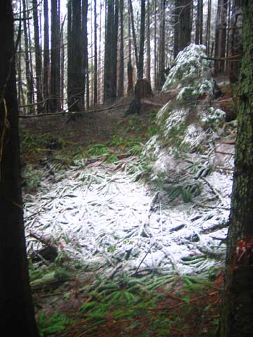 A Lone Tree 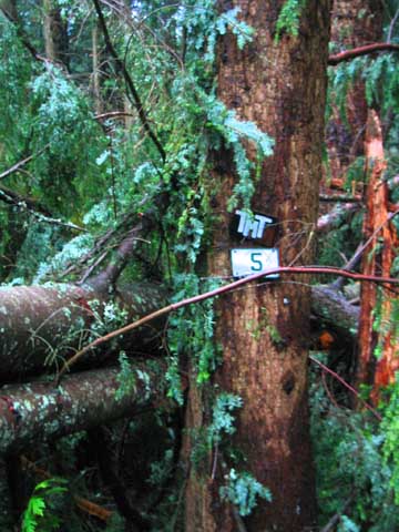 Trail Mauled by Trees
|
| Back to top |
  
|
|
jimmymac
Zip Lock Bagger

Joined: 14 Nov 2003
Posts: 3705 | TRs | Pics
Location: Lake Wittenmyer, WA |
|
jimmymac
Zip Lock Bagger
|
Mon Feb 09, 2004 11:23 pm |
|
|
Wading through acres of blown-down, young trees couldn't have been much fun. Sounds like a heck of a long day. BTW, high lead (leed) refers to the practice of winching bucked timber to a loading area with the log's forward (usually up hill) end elevated above the ground, and the trailing end skidding along. A tall spar "pole" is kept vertical with multiple guy cables. The top of this steel column provides the high anchorage point for the "pulleys" used to winch the timber to the landing.
"Profound serenity is the product of unfaltering Trust and heightened vulnerability."
"Profound serenity is the product of unfaltering Trust and heightened vulnerability."
|
| Back to top |
|
|
ridgewalker
Mountains and Rivers
Joined: 19 Aug 2003
Posts: 223 | TRs | Pics
Location: North Bend |
|
ridgewalker
Mountains and Rivers
|
Tue Feb 10, 2004 12:00 am |
|
|
That makes a lot of sense. I figured it had to do with logging. At the time we needed some humor after the blow downs. The whole length of the trail has debris of logging cables, and pulleys. It is nice that people have left this behind. Reminds me of the Chilkoot Trail where the debris of the gold mining and the journey to the Yukon. There people had picked up soo many "gems" that the trail had to be placed under national park protection. Through the whole trail there were a lot of old stumps. A reminder that not long ago it was old growth all the way down to Elliot Bay.
-- Ridgewalker
|
| Back to top |
|
|
Slugman
Its a Slugfest!

Joined: 27 Mar 2003
Posts: 16874 | TRs | Pics
|
|
Slugman
Its a Slugfest!
|
Tue Feb 10, 2004 1:18 am |
|
|
Reading that report had a dream-like, hypnotic effect, like reading the Rime of the Ancient Mariner. A long day of rough travel for sure. More than I've ever done, even without the blowdowns.
|
| Back to top |
|
|
gorthok
Member

Joined: 13 Feb 2004
Posts: 10 | TRs | Pics
Location: Seattle |
|
gorthok
Member
|
Fri Feb 13, 2004 9:05 am right on, man!
|
|
|
in the darkness you hear a cry...
...what?
|
| Back to top |
|
|
supernaut
Member

Joined: 07 Jan 2004
Posts: 9 | TRs | Pics
|
|
supernaut
Member
|
Fri Feb 13, 2004 2:50 pm The REST of the story. (or The TMT and it's Wicked Ways)
|
|
|
Let me tell you that the ridgewalkers prose is accurate. That F'n hike was pain wrought with destruction. Trail? Pshaw! Just a grinding rage through the woods for the first 7/16th or so of the hike. Then we actually FIND the trail, and I lead us promptly the wrong way, up a steep grade. Good thing Ridgewalker walker had his nuts about him or I would have taken us right up to the top of middle tiger. And there we would've stood like a couple of dwarves bereft of our ale, wondering what the hell we were doing looking off the top of a mountain we should have traversed the western slope of. As it is the Ridgewalker put a stop to my dumbness and had us going the right way in no time. The madness doesn't end there though. Soon after we run right back into a medley of windfalls, once again obliterating the trail. This second swath of defiance from the mountain was less than the previous, and in addition to the many intermittent windfalls in between. About halfway through this second section is where we ran into the first 2 trail runners. And that surveyors tape ridgewalker mentioned? It leads directly <i>away</i> from the trail in the middle of the second section of blowdowns. Soon after that we ran across the trail running asian chick who looked surprisingly clean in stark contrast to our haggard and mangy appearance. I could almost hear her thinking "see ya later suckers!" as we trudged onward under the weight of our internal frame packs and she gracefully jaunted away like a gazelle. At some point soon after that we stopped and rested for a short while, as close to lunch as we were going to get. Somewhere in here it had turned from a downpour into snow. As I sat gorging myself on water and a power bar (my fourth or so of the day) steam poured off of my legs. I was wearing polyester long underwear and mid length polyester shorts so i had awesome breathability going on despite my total lack of water repellency. Ridgewalker led on and I staggered along behind being sorely abused by my new boots, new ill-adjusted internal frame pack
( 5,122 ci  ) and my legs and smokers lungs being out of shape. Ridgewalker kept snapping shots of random stuff that I could have given a crap about at that point. I was deep into the determination zone at this point and any distractions such as the "mythical tree" would have been met with swift kick and a laugh rolling straight up from my belly. As it was I noticed none of this. About the time we got to the point where the tmt crosses between west tiger peaks 3 & 2 a hiker came up the opposite way and asked me if the trail circled around to the parking lot. I said something about this being a one way gig and he needed to go back the other way to reach his vehicle. Of course there are myriad ways from that point back to the north end, but he was obviously without a map so i figured why confuse him. Just after I started down the TMT's steepest set of switch backs (the ones after w. tiger peaks 3 & 2) I pulled out some gloves and banana and ran directly into an old dude laying waste to a rotting stump with a brush bar. He said the trail down should be easier and that my buddy had passed by 5 minutes earlier (it took me awhile to get the gloves on my cold wet hands so i fell behind). A short way down the trail I saw the rest of his gear. The old dude had a freakin' misery whip just chillin' there like it was no big deal. I know those things are standard trail maintanence tools, but it still looks like trouble on a stick to me. After that I saw some more blowdowns and i lept into it head on, now being on my fourth or fifth wind. Not much later I realized that me clammering over and under more fallen trees was a direct result of me overrunning a switchback and charging off into the woods like a tenderfoot with a bota bag. After some good natured cursing I stomped back to the trail and proceeded down the steep swtichbacks to find Ridgewalker either stopped or coming back up to get me. I couldn't tell which, and had no time for pleasantries, I had somehow managed to get some steam and I knew exactly how far we still had to go; having hiked that end of the trail many times. So down we went, across the multiple bridges, up the switchbacks, across the traverse and down the final switchbacks. At the trail head I was a shadow of a man, somehow I swear it even hurt to think. So a quick group shot of Ridgewalker and myself and we went onward to Issaquah and got to the bus stop where some random guy asked us if we were extremers. I thought he meant triple black diamond skiing or base jumping so I said no, we just hiked around on tiger mountain. To him that meant we were extremers and he stated as much. I guess standing there looking as we did among the rest of the populace of front street and sunset blvd in issaquah it wasn't far from the mark. ) and my legs and smokers lungs being out of shape. Ridgewalker kept snapping shots of random stuff that I could have given a crap about at that point. I was deep into the determination zone at this point and any distractions such as the "mythical tree" would have been met with swift kick and a laugh rolling straight up from my belly. As it was I noticed none of this. About the time we got to the point where the tmt crosses between west tiger peaks 3 & 2 a hiker came up the opposite way and asked me if the trail circled around to the parking lot. I said something about this being a one way gig and he needed to go back the other way to reach his vehicle. Of course there are myriad ways from that point back to the north end, but he was obviously without a map so i figured why confuse him. Just after I started down the TMT's steepest set of switch backs (the ones after w. tiger peaks 3 & 2) I pulled out some gloves and banana and ran directly into an old dude laying waste to a rotting stump with a brush bar. He said the trail down should be easier and that my buddy had passed by 5 minutes earlier (it took me awhile to get the gloves on my cold wet hands so i fell behind). A short way down the trail I saw the rest of his gear. The old dude had a freakin' misery whip just chillin' there like it was no big deal. I know those things are standard trail maintanence tools, but it still looks like trouble on a stick to me. After that I saw some more blowdowns and i lept into it head on, now being on my fourth or fifth wind. Not much later I realized that me clammering over and under more fallen trees was a direct result of me overrunning a switchback and charging off into the woods like a tenderfoot with a bota bag. After some good natured cursing I stomped back to the trail and proceeded down the steep swtichbacks to find Ridgewalker either stopped or coming back up to get me. I couldn't tell which, and had no time for pleasantries, I had somehow managed to get some steam and I knew exactly how far we still had to go; having hiked that end of the trail many times. So down we went, across the multiple bridges, up the switchbacks, across the traverse and down the final switchbacks. At the trail head I was a shadow of a man, somehow I swear it even hurt to think. So a quick group shot of Ridgewalker and myself and we went onward to Issaquah and got to the bus stop where some random guy asked us if we were extremers. I thought he meant triple black diamond skiing or base jumping so I said no, we just hiked around on tiger mountain. To him that meant we were extremers and he stated as much. I guess standing there looking as we did among the rest of the populace of front street and sunset blvd in issaquah it wasn't far from the mark.
|
| Back to top |
|
|
Slugman
Its a Slugfest!

Joined: 27 Mar 2003
Posts: 16874 | TRs | Pics
|
|
Slugman
Its a Slugfest!
|
Fri Feb 13, 2004 8:31 pm |
|
|
|
| Back to top |
|
|
JimK
Member

Joined: 07 Feb 2002
Posts: 5606 | TRs | Pics
Location: Ballard |
|
JimK
Member
|
Fri Feb 13, 2004 10:46 pm |
|
|
You folks had a much more difficult time than I did a few years back when there was not a single branch across the trail. It is a nice long hike in the winter when 17 miles on dirt is so hard to find.
Now that you have done the TMT the only challenge left on Tiger is the Six Summits Loop. Just so the trip is not pointless, throw in Poo Poo Point with all six summits. It can be done in less than 20 miles but it takes some imagination. Our version was 19 miles with 4400' gained.
|
| Back to top |
|
|
jimmymac
Zip Lock Bagger
Joined: 14 Nov 2003
Posts: 3705 | TRs | Pics
Location: Lake Wittenmyer, WA |
|
jimmymac
Zip Lock Bagger
|
Sat Feb 14, 2004 1:52 pm |
|
|
I'm tempted by a Rattlesnake Lake - Issaquah High School hike.
The run across Rattlesnake is straightforward. As the power lines start to drop down the west end of Rattlesnake, the grade is too steep for a trail/road. So the trail loops through the woods north of the corridor and rejoins a wide trail or abandoned road that follows the power lines down the slope. That wooded section of trail had become sketchy, even before the November storm.
I know if you continue SW on the power line service road from the Rattlesnake substation, it's just a short jog over to the SR 18 bridge across the Raging River. (The power lines and SR 18 converge and cross the Raging River at about the same place.) The walking route then jogs right back off of SR 18 to the BPA service road. From there, it's easy to connect with the Tiger Mt trails and roads.
Has anybody done this jaunt? How's the blowdown situation on top of Rattlesnake? Any advice on Tiger Mt trail selection relative to the remaining blowdowns would be helpful. Thanks.
"Profound serenity is the product of unfaltering Trust and heightened vulnerability."
"Profound serenity is the product of unfaltering Trust and heightened vulnerability."
|
| Back to top |
|
|
|
|
You cannot post new topics in this forum
You cannot reply to topics in this forum
You cannot edit your posts in this forum
You cannot delete your posts in this forum
You cannot vote in polls in this forum
|
Disclosure: As an Amazon Associate NWHikers.net earns from qualifying purchases when you use our link(s). |


 what the heck is this place anyway. Killer trail description man. i felt like i was there all the way through it. where was that tree? that thing looks almost mythical it's so random. so jack frost's outpost looking. i really think that, to an extent, wandering through that windblown part of the trial was a lot of fun. i haven't run into anything like that since the clear-cut blew down over the rifle range trail from brinkley to omache.