Mentalfloss
Member

Joined: 04 Apr 2002
Posts: 78 | TRs | Pics
Location: Portland |
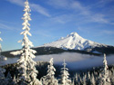
On June 2, 2002 I took a day hike up Horseshoe Ridge which is part of a ridge and peak complex to the west of Mt. Hood.
The trailhead is above the Riley Horse Camp which is a few miles out road 18, then road 1825, north of Zigzag. Drive past the sign at the entrance of Riley Camp onto a gravel road that winds upward for a few short miles. You'll pass a sign for the Horseshoe Ridge trailhead on your left. You can start here. Or you can drive on for another mile or two and start at a higher trailhead on your left. The last 1/3 of a mile of this upper road was overgrown with alder at the sides and will scratch up your car if you care.
There is car clouting reported here so keep that in mind.
Sign in and get a self-issuing wilderness permit and head on up the trail. You'll pass through mostly Western hemlock, red cedar, and silver and white fir forest. About 30-45 minutes in you'll come to a 90 degree angle in the trail, to the right, marked by a tall red stump. Just beyond that, on the right side of the trail is a big red snag. To your left is a green ramp leading upward. If you wish you can follow this up to a rocky point with nice views. Pay attention here. There's no trail and there are dangerous, rocky, steep spots. But there are some nice views from the top.
However, most will continue on the trail. Soon after entering the wilderness I got into a gradually increasing area of blowdown. I don't know if/when this will be cleaned up, but I wanted to let folks know that it's there now.
The blowdown worsened until I came to a steep, more open slope covered with hard snow and blowdown. I started across this but since I was alone and it was a long, rough fall if I happened to slip I turned back.
From the maps I can see that the top of this ridge holds a couple of small lakes and connects to trails that lead to Zigzag mountain and others. There would be wide open views from Rainier to Jefferson from there as well as a close-up view of Hood's beautiful west face. You might be able to see downtown Portland, but I'm not sure of that. Heck, I'm not sure you'd want to see that even if you could.
|


