| Previous :: Next Topic |
| Author |
Message |
Plinko
Member

Joined: 22 Apr 2003
Posts: 214 | TRs | Pics
Location: Seattle-ish |
|
Plinko
Member
|
 Wed Jun 23, 2004 2:31 am |
|
|
If it's yours, let me know...
I was on my way to Blethen Lakes and on up to Bessemer and found it maybe 3 miles in, along the old roadbed.
As for a trip report, it's pretty easy going along the Quartz Creek trail (Road 5640), gently ascending from 1100 up to 2900 over 4 miles. There's two stream crossings on bridge remnants (5' diameter logs that span 30-50 feet respectively), and a third stream crossing where the bridge has been washed away completely. Ascend briefly to where crossing is simple on dry rock. If it's raining, there's a prickly handline that I'd recommend hanging on to. Shortly after this third crossing, the trail becomes almost continuous brush for about 1/2 mile, but it's still pretty easy to follow along as it continues straight ahead. At this point, the official trail ends (thankfully) and the way leaves the alder and nettle infested roadbed in exchange for a slightly more meandering trail that's surprisingly brush-free. This ascends 300 vertical feet in the final 0.6 mile to reach Blethen Lake at it's eastern outlet. From here on, all vestiges of a waytrail are concealed by thick waist-high brush. This is the point where one realizes an early-season or winter hike would have helped avoid the brush, but from the lake shore, Bessemer Mt. is beckoning in the distance. I heeded it's call and began the journey around the south shore of the lake through avalanche lilies, stinging nettle, slide alder, larch and many other species who's acquaintance I was not pleased to make. The bushwhack soon turned to full on hand-to-hand combat. The brush, not wanting to be defeated, called in air strikes from above, and despite my thorough application of 100% DEET at the journey's start, the resulting cloud of insects was thick enough to warrant the donning of the headnet. With vision obscured by the sun reflecting against the headnet, the going was slow and painful, like traveling up a 30 degree slope in 4 feet of new, unconsolidated snow, with whip-bearing lawn gnomes lashing incessantly at my bare legs as I continued to painfully inch my way up away from the lake and up the boulder field to the west. The boulder field offered a slight reprieve from the torture and a chance to finally drink and catch my breath and to ask myself yet again why I'm attempting this in summer. The hopscotch up the boulder field ascends nearly 500 vertical feet to arrive at Upper Lake Blethen. The return trip was equally painful, but only for a short section near the lake.
Usually I'm inclined to not share info on such an under used trail as this, but in this case I think if more people hiked to Blethen there would be a lot less brush to have to wade through between mile 3 and mile 4 and everyone would win. Go there, see it for yourself, beautiful scenery that's close yet remote.
The report on the continued ascent up Bessemer with photos (up the steep obvious gully on the north slope to the saddle, and on up to the top, class 4) will be filed on NW Peakbaggers Asylum or CascadeClimbers.com. If Bessemer is your goal, most folks hit it from the south approach, up Middle Connector a.k.a. CCC Rd. on mtn bike or skis. I couldnt find much info on the north approach other than a vague account in the brown Beckey. If youre inclined to do the north side, an approach variation up Rd. 32400 off North Fork Road will take you past Lake Hancock on the north, and on up to Upper Lake Blethen avoiding all the bushwhacking nastiness that goes with the Quartz Creek approach. I would guess that access via 32400 is gated to all but the tree rapists, so a mountain bike in the summer, or ski approach in winter/spring would help trim the fat from the approach.
Cheers!
|
| Back to top |
  
|
|
Allison
Feckless Swooner

Joined: 17 Dec 2001
Posts: 12287 | TRs | Pics
Location: putting on my Nikes before the comet comes |
|
Allison
Feckless Swooner
|
Wed Jun 23, 2004 6:44 am |
|
|
That's not my hanky, but I lost my alti watch on the way up there last year. If you have that, let me know.  Blethen's nice though, innit?
www.allisonoutside.com
follow me on Twitter! @AllisonLWoods
www.allisonoutside.com
follow me on Twitter! @AllisonLWoods
|
| Back to top |
|
|
Scrooge
Famous Grouse

Joined: 16 Dec 2001
Posts: 6966 | TRs | Pics
Location: wishful thinking |
|
Scrooge
Famous Grouse
|
Wed Jun 23, 2004 10:07 pm |
|
|
Been to both Blethens, but never done the stretch in between.  Probably nothing will ease that brush bash to Lower Blethen but conversion to a formal trail. Ira Spring advocated that in his "Roads to Trails" book, and the routes in it were ones the Forest Service had agreed had trail potential.
Went swimming in Upper Blethen, but shouldn't have. The verge is one of those beautiful false lawns that's actually the surface of a shoreline bog. A dozen people making my mistake would turn the shore into a quagmire.
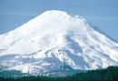
The north side of Bessemer's dramatically different from the clearcut south side, a rather beautiful, spectacular arete, reminiscent of something in the Canadian Rockies. It would make a very respectable climb, Plinko.
Probably nothing will ease that brush bash to Lower Blethen but conversion to a formal trail. Ira Spring advocated that in his "Roads to Trails" book, and the routes in it were ones the Forest Service had agreed had trail potential.
Went swimming in Upper Blethen, but shouldn't have. The verge is one of those beautiful false lawns that's actually the surface of a shoreline bog. A dozen people making my mistake would turn the shore into a quagmire.
The north side of Bessemer's dramatically different from the clearcut south side, a rather beautiful, spectacular arete, reminiscent of something in the Canadian Rockies. It would make a very respectable climb, Plinko. 
Something lost behind the ranges. Lost and waiting for you....... Go and find it. Go!
Something lost behind the ranges. Lost and waiting for you....... Go and find it. Go!
|
| Back to top |
|
|
|
|
You cannot post new topics in this forum
You cannot reply to topics in this forum
You cannot edit your posts in this forum
You cannot delete your posts in this forum
You cannot vote in polls in this forum
|
Disclosure: As an Amazon Associate NWHikers.net earns from qualifying purchases when you use our link(s). |


