Elvis
Shuffl'n


Joined: 09 Jun 2004
Posts: 1804 | TRs | Pics
Location: del Boca Vista |
|
Elvis
Shuffl'n
|
 Mon Sep 13, 2004 2:16 pm |
|
|
Desolation Peak is located at the northern end of Ross Lake, off of Hwy 20 (North Cascade Highway). A trip to Desolation Peak requires pre-planning as access to the trailhead is obtained via a long boat ride or via a 15 or so mile hike along the East Bank Trail.
This trip report is my story of the events that took place the weekend of Sep 11 & 12, 2004. Hopefully it will be useful to a future visitor - or at least of some entertainment value for those of you who spend a lot of time in this forum.
Our group consisted of a total of 10 people. All were friends and/or acquaintances from my previous job working with organic foods for Cascadian Farm and Muir Glen (www.cfarm.com and www.muirglen.com). A great group of people! The youngest in our group was Kile, age 14 (and he did great!).
Five of the group departed Friday afternoon and camped that evening at Green Point on Ross Lake. This is located next to Ross Lake Resort. That evening they rented three canoes and a 17' motorboat for the weekend. Lots of rain came that night, some stayed dry, others didn't. Hint: if you expect rain, try to avoid the lowest tent site.
Saturday morning, the other five people arrived at the Ross Dam parking lot at about 6:30am. We strapped on the packs and hiked the steep 1 mile trail down to the Ross Lake Resort Boat pick-up area where one of our group motored down to ferry us to the Green Point base camp. Due to the size of the boat we had to take two trips.
We loaded the canoes and the motor boat and started the 18 mile boat journey toward the trailhead. (See pic 072 and 073). Weather was chilly and cloudy with minimal wind.
With all the rain on Friday night, there were numerous waterfalls that we could see which were all swollen - many of which disappeared from sight by the time we returned on Sunday.
Rain came and went throughout the morning, but we were gifted with Rainbows for the first two hours of our trip. Pic 079 shows some swollen waterfalls near the Big Beaver campground with one of the many rainbows.
I rode in the motorboat  up to Cat Island (about 15 miles uplake and 2 miles before the trailhead) where I jumped out and started to set up camp (see pic 087). Meanwhile, the motorboat circled back to check on the canoers. Pic 091 shows another Rainbow just west of Cat Island.
The weather began to change for the worse... the winds picked up, as did the waves and on/off rain. The motorboat group found the canoers at Devils Creek campground, about 10 miles away from the starting point. It was decided that due to weather we should leave the canoes and just ferry to the trailhead. First boatload brought Wayne and Kile to Cat Island so they could set up camp. 2nd and 3rd trip took the rest of the gang to the trail head. Finally, the boat returned to pick up the Island residents so we could all assemble at the trailhead... it's now 1:30pm.
We climbed the 4.5 miles and 4,500 feet to the summit. We all survived the trail which is true to it's description: Starts steep and stays steep. The first half of the trail is through the trees with periodic views of the lake - it's amazing how fast the lake falls below you. The second half goes through meadows, providing views of Lodgepole and Ponderosa campgrounds, as well as 10-mile island and distant peaks. See pic 094. Trail is in good condition, although some portions were overgrown a tad but there was never a question as to the trail route (until the 'Y').
With lighter packs (since we left most of our gear on the Island) the three 'Islanders' led the way up the trail. Near the top of the meadow we came to a 'Y' with a wooden post that is so worn an tattered you have to guess at what the wording was. Looking very carefully, it tells you that Desolation Camp and Toilet is off to the Right. We headed off to the left toward the summit and the Fire Lookout. The plan was for everyone else (who were all camping at the top) would go to the camp and drop their gear before heading to the summit. Unfortunately for them, they didn't interpret the sign and continued to the left with all their gear. oops. up to Cat Island (about 15 miles uplake and 2 miles before the trailhead) where I jumped out and started to set up camp (see pic 087). Meanwhile, the motorboat circled back to check on the canoers. Pic 091 shows another Rainbow just west of Cat Island.
The weather began to change for the worse... the winds picked up, as did the waves and on/off rain. The motorboat group found the canoers at Devils Creek campground, about 10 miles away from the starting point. It was decided that due to weather we should leave the canoes and just ferry to the trailhead. First boatload brought Wayne and Kile to Cat Island so they could set up camp. 2nd and 3rd trip took the rest of the gang to the trail head. Finally, the boat returned to pick up the Island residents so we could all assemble at the trailhead... it's now 1:30pm.
We climbed the 4.5 miles and 4,500 feet to the summit. We all survived the trail which is true to it's description: Starts steep and stays steep. The first half of the trail is through the trees with periodic views of the lake - it's amazing how fast the lake falls below you. The second half goes through meadows, providing views of Lodgepole and Ponderosa campgrounds, as well as 10-mile island and distant peaks. See pic 094. Trail is in good condition, although some portions were overgrown a tad but there was never a question as to the trail route (until the 'Y').
With lighter packs (since we left most of our gear on the Island) the three 'Islanders' led the way up the trail. Near the top of the meadow we came to a 'Y' with a wooden post that is so worn an tattered you have to guess at what the wording was. Looking very carefully, it tells you that Desolation Camp and Toilet is off to the Right. We headed off to the left toward the summit and the Fire Lookout. The plan was for everyone else (who were all camping at the top) would go to the camp and drop their gear before heading to the summit. Unfortunately for them, they didn't interpret the sign and continued to the left with all their gear. oops.  Finally, we were all at the summit, taking in the limited views available between rolling clouds. It was breezy and cold - I guess 40 degrees. Sucking water from a camel pack would provide COLD water from the hose and then warm water as the hose filled with water from inside the pack. We took the required pictures (Pic 096, 099 and 100) and some group photos, congratulations and then headed back down at just after 5:30pm.
Seven of the group took the spur to set up their camp and the remaining three of us started our descent, hoping we'd be back on the island by dark. We made it - just barely. Descent took us almost exactly two hours. No wildlife was seen on the hike, except for the occasional squirrel. Bears must have been on vacation.
We cooked dinner in the dark and went to bed. There was minimal rain at night and the winds picked up for an hour or so, then died down.
We woke at 7:00am, ate, re-packed and lounged around, enjoying the periodic sun breaks and the quiet. Meanwhile, the summit-campers woke between 5:00 and 6:00 and went back to the summit for somewhat better views. I was told that at the Lookout in the morning they located a thermometer that indicated temperature was 30 degrees (elevation about 6,103). brrr...
We all met at the trailhead at 10:30 to start ferrying to Canoes. While I ferried the first four people, the other continued hiking along the lake to Lightning Creek campground. When I arrived back there we took a break for some coffee and a couple opted for a short swim. It was obvious that two of the campers hanging out on the beach were quite pleased with the sight of one of our female swimmers - possibly the highlight of their trip! Sorry - no pictures of the swimming escapade. A short while later we were visited by a couple of Rangers out on patrol (National Park Service, I guess). For the gals out there, our female swimmer declared them 'Yummy!'
Finally, we were all at the summit, taking in the limited views available between rolling clouds. It was breezy and cold - I guess 40 degrees. Sucking water from a camel pack would provide COLD water from the hose and then warm water as the hose filled with water from inside the pack. We took the required pictures (Pic 096, 099 and 100) and some group photos, congratulations and then headed back down at just after 5:30pm.
Seven of the group took the spur to set up their camp and the remaining three of us started our descent, hoping we'd be back on the island by dark. We made it - just barely. Descent took us almost exactly two hours. No wildlife was seen on the hike, except for the occasional squirrel. Bears must have been on vacation.
We cooked dinner in the dark and went to bed. There was minimal rain at night and the winds picked up for an hour or so, then died down.
We woke at 7:00am, ate, re-packed and lounged around, enjoying the periodic sun breaks and the quiet. Meanwhile, the summit-campers woke between 5:00 and 6:00 and went back to the summit for somewhat better views. I was told that at the Lookout in the morning they located a thermometer that indicated temperature was 30 degrees (elevation about 6,103). brrr...
We all met at the trailhead at 10:30 to start ferrying to Canoes. While I ferried the first four people, the other continued hiking along the lake to Lightning Creek campground. When I arrived back there we took a break for some coffee and a couple opted for a short swim. It was obvious that two of the campers hanging out on the beach were quite pleased with the sight of one of our female swimmers - possibly the highlight of their trip! Sorry - no pictures of the swimming escapade. A short while later we were visited by a couple of Rangers out on patrol (National Park Service, I guess). For the gals out there, our female swimmer declared them 'Yummy!'  By the time we left the weather had turned windy and the water choppy. When we arrived at the final beached canoe, we opted to tie it to our boat and pull it along behind us until we caught up with the first two canoes that had set sail 1 1/2 hours before. When we finally caught up with them we loaded the third canoe and gave Kile a well deserved break in the motorboat.
On the final leg of ride back to the Resort we (in the motorboat) took some time to explore the Big Beaver campground and also hiked around Cougar Island while keeping tabs on the canoe progress.
The last 500 yards around Green Point and into the Resort was being torn up by high winds so we assisted the third canoe into it's dock very carefully. We paid our $430 rental bill for all the boats and had a fun (but very brief) 60mph ride over choppy water from the resort to the dock at the dam. We strapped on our packs for the final mile hike up to the parking lot. We congratulated each other and then headed to Concrete for Pizza and Beer at Annie's Pizza (next to the Red Apple Market - highly recommended for anyone passing through).
I'd give the overall trip an A- as it will never be forgotten. It could have received an A+ if the weather wasn't at a 'D' level. I'd rate it as 'very difficult' due to the elevation gain and the sheer complexity of reaching the trailhead.
Future visitors be advised: You need a permit to park in the parking lot, you need a back country permit for staying overnight, you need a bear cannister to hang your food in (if camping at the top, other sites have food lockers already in place) and you need to be prepared for drastic weather changes. Also, as many reports say, there is no water on top. Even with all the rain there was only one SMALL dribble of water that crossed the trail... although our summit campers did collect enough water from rainfall on their tarp to boil pasta. Bring water with you.
I'm marking this destination off my list and looking for my next adventure. Thanks for Reading... too bad no one was able to fill our last spot which would have allowed an additional canoe boat or motorboat to help ferry people.
By the time we left the weather had turned windy and the water choppy. When we arrived at the final beached canoe, we opted to tie it to our boat and pull it along behind us until we caught up with the first two canoes that had set sail 1 1/2 hours before. When we finally caught up with them we loaded the third canoe and gave Kile a well deserved break in the motorboat.
On the final leg of ride back to the Resort we (in the motorboat) took some time to explore the Big Beaver campground and also hiked around Cougar Island while keeping tabs on the canoe progress.
The last 500 yards around Green Point and into the Resort was being torn up by high winds so we assisted the third canoe into it's dock very carefully. We paid our $430 rental bill for all the boats and had a fun (but very brief) 60mph ride over choppy water from the resort to the dock at the dam. We strapped on our packs for the final mile hike up to the parking lot. We congratulated each other and then headed to Concrete for Pizza and Beer at Annie's Pizza (next to the Red Apple Market - highly recommended for anyone passing through).
I'd give the overall trip an A- as it will never be forgotten. It could have received an A+ if the weather wasn't at a 'D' level. I'd rate it as 'very difficult' due to the elevation gain and the sheer complexity of reaching the trailhead.
Future visitors be advised: You need a permit to park in the parking lot, you need a back country permit for staying overnight, you need a bear cannister to hang your food in (if camping at the top, other sites have food lockers already in place) and you need to be prepared for drastic weather changes. Also, as many reports say, there is no water on top. Even with all the rain there was only one SMALL dribble of water that crossed the trail... although our summit campers did collect enough water from rainfall on their tarp to boil pasta. Bring water with you.
I'm marking this destination off my list and looking for my next adventure. Thanks for Reading... too bad no one was able to fill our last spot which would have allowed an additional canoe boat or motorboat to help ferry people.
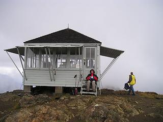 Desolation Peak Lookout 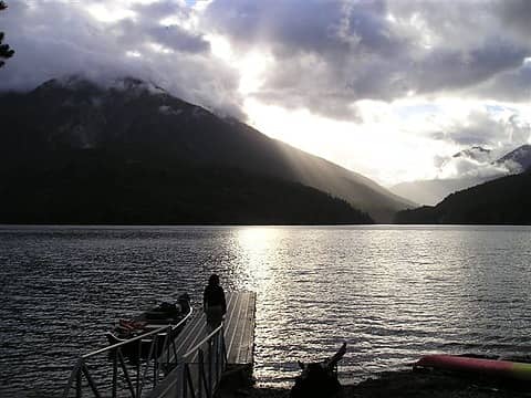 Green Point dock and motorboat 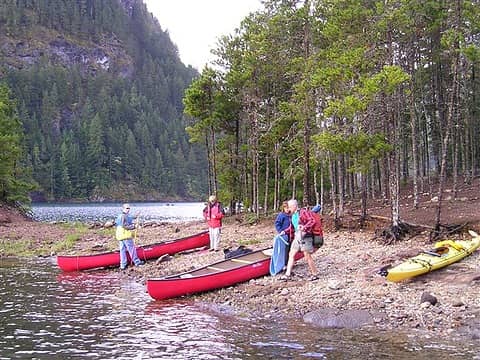 Canoes at Green Point 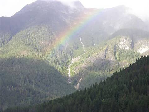 Waterfall near Big Beaver Campground 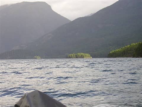 Cat Island - camp 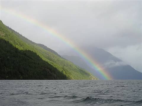 Rainbow over Ridge 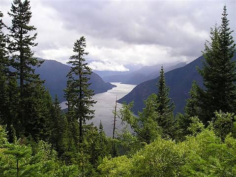 The Best View of Ross Lk 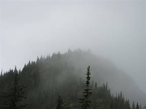 Lookout in the fog 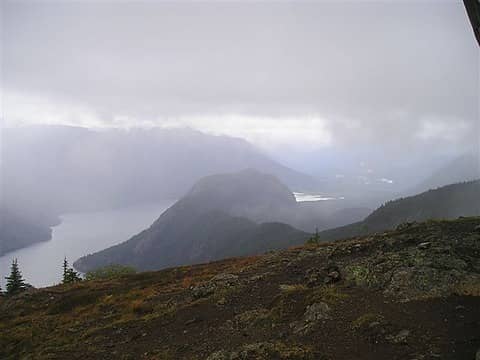 From the Lookout, northward into Canada 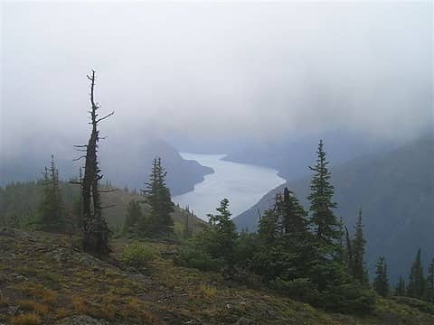 From the Lookout, southward down Ross Lake
"Ill habits gather unseen degrees, as brooks make rivers, rivers run to seas." ~John Dryden
My Trip List
"Ill habits gather unseen degrees, as brooks make rivers, rivers run to seas." ~John Dryden
My Trip List
|


