| Previous :: Next Topic |
| Author |
Message |
dicey
custom title


Joined: 11 May 2004
Posts: 2870 | TRs | Pics
Location: giving cornices a wider berth |
|
dicey
custom title
|
 Sat May 19, 2007 12:59 pm |
|
|
Mark and I first attempted Mt. Kent back in December. This trip ended before it really began when I was swept off my feet by an avalanche while traversing high on the slopes of McClellan Butte.
A rematch was long overdue. Eric, Erin and I were considering some Teanaway action for Friday, but since I needed to be back in the city by 6pm, we decided to have a look closer in if the weather was agreeable. Driving East on I-90 in full on sun with blue skies convinced us we needn't drive any further east today!  We parked at the 'cheaters' parking spot, which is where the McClellen Butte trail crosses road 9020 at about 2400ft(?), and started up the trail at 7:45am. The newly graded switchbacks eased us into a nice steady rhythm until Erin realized she had forgotten Kosmic's leash in the car. As she jogged back down, Eric and I plodded up, knowing she would have no problem catching back up to us - she didn't.
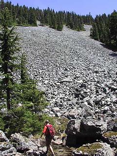
Trail is snow free up to about 3900ft, where we encountered some patches of snow, but nothing to obscure the trail. After about 4000ft, the snow gets deeper and continuous, but at this point you just head SW, crossing many avalanche gullies along the way. At about 5000ft we began our long traverse, mostly following the route of the summer trail to where it curls around the nose of the ridge, and Mt. Rainier pops into view.
We parked at the 'cheaters' parking spot, which is where the McClellen Butte trail crosses road 9020 at about 2400ft(?), and started up the trail at 7:45am. The newly graded switchbacks eased us into a nice steady rhythm until Erin realized she had forgotten Kosmic's leash in the car. As she jogged back down, Eric and I plodded up, knowing she would have no problem catching back up to us - she didn't.
Trail is snow free up to about 3900ft, where we encountered some patches of snow, but nothing to obscure the trail. After about 4000ft, the snow gets deeper and continuous, but at this point you just head SW, crossing many avalanche gullies along the way. At about 5000ft we began our long traverse, mostly following the route of the summer trail to where it curls around the nose of the ridge, and Mt. Rainier pops into view.
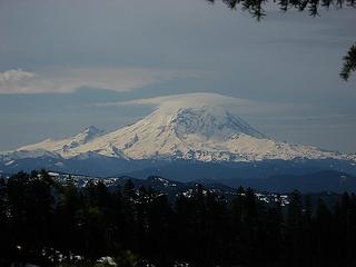 I iz Rainier. U like my hat? 
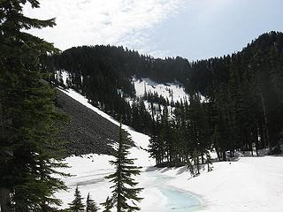 alice lakes basin 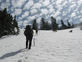 cool clouds 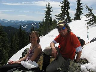 Erin and I on Kent 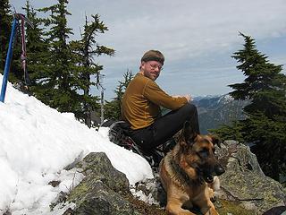 Eric and Kosmic on Kent 5-18-07 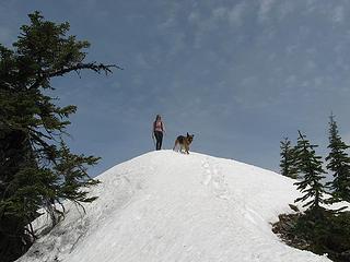 descending Kent 5-18-07  We headed back up the slope to the McClellen Butte trail, which was melted out at the ridge turn. I was suprised to see a couple of folks there who had followed our foot prints and were contemplating continuing on to the summit of McClellan butte. It was 1:30, and we were contemplating hitting this summit as well, but I was concerned about time/traffic/getting back to Seattle. We decided to make a run for it, and agreed to turn back if we hadn't reached the summit by 2:30pm.
We were soon back on solid snow after a few switchbacks, and trying to make good time. As I often do in the snow, I directed us too high, and we popped out a ways above the meadows. We dropped packs here, and glissaded down to the meadows (tarns in the summer), and I promptly led us too high again (impatience). We paralled the ridge on the NE side until we finally gained the notch at the base of the summit scramble. 2pm.
Erin was not certain Kosmic could safely do the last bit of rock scrambling to the summit, so I offered to hold his leash at the notch so that Erin and Erik could complete the climb. We probably had time to tag team the summit, but since I had been up there many times before, I was ok keeping Kosmic company at the base. We headed back up the slope to the McClellen Butte trail, which was melted out at the ridge turn. I was suprised to see a couple of folks there who had followed our foot prints and were contemplating continuing on to the summit of McClellan butte. It was 1:30, and we were contemplating hitting this summit as well, but I was concerned about time/traffic/getting back to Seattle. We decided to make a run for it, and agreed to turn back if we hadn't reached the summit by 2:30pm.
We were soon back on solid snow after a few switchbacks, and trying to make good time. As I often do in the snow, I directed us too high, and we popped out a ways above the meadows. We dropped packs here, and glissaded down to the meadows (tarns in the summer), and I promptly led us too high again (impatience). We paralled the ridge on the NE side until we finally gained the notch at the base of the summit scramble. 2pm.
Erin was not certain Kosmic could safely do the last bit of rock scrambling to the summit, so I offered to hold his leash at the notch so that Erin and Erik could complete the climb. We probably had time to tag team the summit, but since I had been up there many times before, I was ok keeping Kosmic company at the base.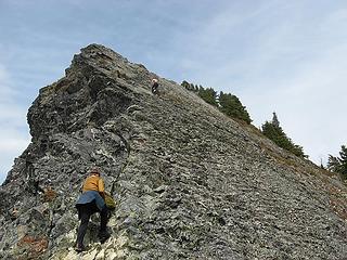 McClellan Butte 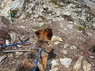 Kosmic watches and worries
|
| Back to top |
  
|
|
moosefish
I am the fish

Joined: 02 Jul 2004
Posts: 1210 | TRs | Pics
Location: monkey herder |
|
moosefish
I am the fish
|
Sat May 19, 2007 1:31 pm |
|
|
Sweet.
The climb from Alice Lakes up to the summit looks a lot more fun in snow than when it's all melted out. Lots of loose rocks about the size of your head.
 up from Alice Lakes in the summer 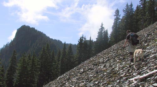 east side of 4684
|
| Back to top |
|
|
dicey
custom title
Joined: 11 May 2004
Posts: 2870 | TRs | Pics
Location: giving cornices a wider berth |
|
dicey
custom title
|
Sat May 19, 2007 8:10 pm |
|
|
Moose,
Yup, I think this peak is best climbed with snow to avoid 'talus horriblus', which is why I was wanting to get back to it sooner than later.
We climbed straight up the nose of the ridge leading to pt4684 from the saddle. Thick, young trees pushed us to the west side near the top. Looks like the east side is more open according to your pic!
|
| Back to top |
|
|
moosefish
I am the fish
Joined: 02 Jul 2004
Posts: 1210 | TRs | Pics
Location: monkey herder |
|
moosefish
I am the fish
|
Sat May 19, 2007 9:32 pm |
|
|
The spot where picture was taken was open and there were two or three fields like that. However, there was quite a bit of young tree syndrome on that side that made the final push to the lakes a pain.
Did you happen to get any pics of the next ridge over and point 4763?
|
| Back to top |
|
|
dicey
custom title
Joined: 11 May 2004
Posts: 2870 | TRs | Pics
Location: giving cornices a wider berth |
|
dicey
custom title
|
Sat May 19, 2007 9:56 pm |
|
|
Yes. I believe it's called the Duke of Kent, along with the Dutchess, etc. Anyway, here is a pic from Kent looking east
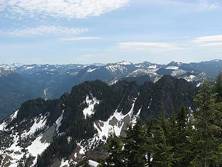 Duke of Kent pt4763 (and court) from Mt Kent
|
| Back to top |
|
|
umbrella lady
umbrella lady

Joined: 10 May 2007
Posts: 66 | TRs | Pics
Location: issaquah |
I have to thank you for putting in steps in the snow, I had never been to Kent before and wanted to so followed your downhill steps up and back, worked out well and were needed today because it was snowing and no visibility. Only difference I did was park in the regular lot, can anyone drive up to the higher parking place? Thanks again for all your steps and photos, because it didn't look as nice and the sunshine was missing.
|
| Back to top |
|
|
ErinB
Member
Joined: 23 Jun 2006
Posts: 34 | TRs | Pics
|
|
ErinB
Member
|
Sun May 20, 2007 9:45 pm |
|
|
We were so fortunate with the beautiful weather! Quite a fun day, with just enough of the adventure needed for a satisfactory day in the mountains
here are a few more photos: The neverending traverse Another shot of Kos and Eric 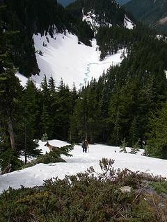 The other part of Alice Lakes basin, from the ridge
|
| Back to top |
|
|
Matt
Tea, Earl Grey, Hot

Joined: 30 Jan 2007
Posts: 4307 | TRs | Pics
Location: Shoreline |
|
Matt
Tea, Earl Grey, Hot
|
Sun May 20, 2007 10:54 pm |
|
|
Kos & Eric appear to have matching facial hair.
Dicey, nice cottonball clouds picture.
As beacons mountains burned at evening. J.R.R. Tolkien
As beacons mountains burned at evening. J.R.R. Tolkien
|
| Back to top |
|
|
Layback
Cascades Expatriate

Joined: 16 Mar 2007
Posts: 5712 | TRs | Pics
Location: Back East |
|
Layback
Cascades Expatriate
|
Sun May 20, 2007 11:00 pm |
|
|
| Matt wrote: | | Kos & Eric appear to have matching facial hair.
Dicey, nice cottonball clouds picture. |
Another shot of Kos and Eric 
|
| Back to top |
|
|
puzzlr
Mid Fork Rocks

Joined: 13 Feb 2007
Posts: 7220 | TRs | Pics
Location: Stuck in the middle |
|
puzzlr
Mid Fork Rocks
|
Sun May 20, 2007 11:16 pm |
|
|
Nice to hear you tied up that loose end.
Speaking of the watershed boundary, last summer I biked to the back of Mt Gardner starting from a gate on the road by Humpback peak, ignoring the signs to keep out. I hiked up the final bit for a quick summit (that's really cheating!). When I got home I wondered what the penalty is for being in the watershed and how one would get caught. I searched the internet for 30 minutes but couldn't find any information or stories about that. Has anyone been caught in the watershed? Fined?
|
| Back to top |
|
|
dicey
custom title
Joined: 11 May 2004
Posts: 2870 | TRs | Pics
Location: giving cornices a wider berth |
|
dicey
custom title
|
Sun May 20, 2007 11:25 pm |
|
|
| umbrella lady wrote: | | Only difference I did was park in the regular lot, can anyone drive up to the higher parking place? |
Yes!
Anyone can drive up this road. Take exit 38, take a right and follow this road until you see FS9020. Take this road up a mile or two until you see where the trail crosses over it. Park and start walking 'cheater'. 
|
| Back to top |
|
|
EastKing
Surfing and Hiking

Joined: 28 Mar 2007
Posts: 2082 | TRs | Pics
Location: 77 miles from Seattle! |
|
EastKing
Surfing and Hiking
|
Sun May 20, 2007 11:44 pm |
|
|
Wow, great trip report and pictures. Looks like a fun day!
YouTube | SummitPost
Saw the depths of despair. Now I am salvaging what time I have left on Earth.
YouTube | SummitPost
Saw the depths of despair. Now I am salvaging what time I have left on Earth.
|
| Back to top |
|
|
|
|


