| Previous :: Next Topic |
| Author |
Message |
Opus
Wannabe


Joined: 04 Mar 2006
Posts: 3700 | TRs | Pics
Location: The big rock candy mountain |
|
Opus
Wannabe
|
 Sat Jun 02, 2007 11:45 pm |
|
|
Well I finally made it it to Big Snow! And I can now say that my car has been up the Middle Fork road. Its one and only trip, thankfully. We made it all the way in my Outback without incident. Despite keeping our eyes out we didn't spot any Geos up there today. The road is pretty good. I'd say any vehicle with decent clearance can make it. We had to inch our way through some of the dips to avoid scraping the long overhangs though. A vehicle with better approach angles would make for an easier drive.
Oddly when we turned off near the Taylor junction there was a crowd of people standing by the side of the road. Down the hill in the bushes was an upside down truck. One guy told us not to worry, that happened last night. Hopefully the drive walked away. Very odd place to wreck too, it wasn't even on a curve.  On our drive out the truck was gone.
After a long, bouncy drive we reached the trailhead at the incredibly late hour of 10:15. I seem to be in the minority with my friends on getting early starts. We started up in the humid overgrown trail and with many route finding errors made it to lower Hardscrabble around noon. Thus far it was mostly snow free, with some patches in the trees. We traversed around the left of the lake and at the outlet started up to Upper Hardscrabble. This was the roughest part of the trip - lots of patchy undermined snow made for slow travel. We made the upper lake, said "hi" to some fishers, and began up the gully.
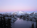
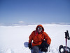
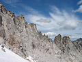
On the ridge the views were spectacular! Peaks in every direction. We could see Lake Dorothy down below too, melted out. Gold lake and Big Snow Lake were both still frozen. Traversing across the ridge to the summit was very slow going but very cool. The whole ridge looked like a wall of snowy sand dunes. It took almost an hour, but we made it across and up to the summit. Great views everywhere! We unfortunately didn't have the chance to linger too long before starting our descent.
We made good time back to the gully and glissaded part way back down. The other group of hikers we encountered stopped at the base of it to refill on water while we pushed on. We stopped at the outlet of lower Hardscrabble ourselves to refill. The sun was behind the ridge now and temperatures were much milder, making for easier traveling. I'd sunburned my knees between my shorts and gaiters, and was now feeling the affects. The traverse around the lake was slow and careful. Those snow covered boulders are melting out fast - we could see several bottomless pits that we had to carefully avoid! We finally made it back to the car around six, packed up, and started the tedious drive back out.
What a great trip! Big thanks to Ragman and Rodman for their last trip report and the helpful GPS map! I'm glad I had a chance to see the area before that gate closes. On our drive out the truck was gone.
After a long, bouncy drive we reached the trailhead at the incredibly late hour of 10:15. I seem to be in the minority with my friends on getting early starts. We started up in the humid overgrown trail and with many route finding errors made it to lower Hardscrabble around noon. Thus far it was mostly snow free, with some patches in the trees. We traversed around the left of the lake and at the outlet started up to Upper Hardscrabble. This was the roughest part of the trip - lots of patchy undermined snow made for slow travel. We made the upper lake, said "hi" to some fishers, and began up the gully.
On the ridge the views were spectacular! Peaks in every direction. We could see Lake Dorothy down below too, melted out. Gold lake and Big Snow Lake were both still frozen. Traversing across the ridge to the summit was very slow going but very cool. The whole ridge looked like a wall of snowy sand dunes. It took almost an hour, but we made it across and up to the summit. Great views everywhere! We unfortunately didn't have the chance to linger too long before starting our descent.
We made good time back to the gully and glissaded part way back down. The other group of hikers we encountered stopped at the base of it to refill on water while we pushed on. We stopped at the outlet of lower Hardscrabble ourselves to refill. The sun was behind the ridge now and temperatures were much milder, making for easier traveling. I'd sunburned my knees between my shorts and gaiters, and was now feeling the affects. The traverse around the lake was slow and careful. Those snow covered boulders are melting out fast - we could see several bottomless pits that we had to carefully avoid! We finally made it back to the car around six, packed up, and started the tedious drive back out.
What a great trip! Big thanks to Ragman and Rodman for their last trip report and the helpful GPS map! I'm glad I had a chance to see the area before that gate closes. 
 Falls and peak  Looking back  At the top of the gully  Snow dunes  Distant summit  Traversing the saddle  Going up  Descending climbers  On the top  Great view  The traverse back  Tiny climbers  Glissade  View down  Summit panorama
|
| Back to top |
  
|
|
Type E
Member

Joined: 19 Aug 2006
Posts: 1381 | TRs | Pics
|
|
Type E
Member
|
Sun Jun 03, 2007 12:28 am |
|
|
again I am very jealous. I am glad you had the views we missed out on1
|
| Back to top |
|
|
peltoms
Member

Joined: 13 Jul 2006
Posts: 1760 | TRs | Pics
Location: Worcester MA |
|
peltoms
Member
|
Sun Jun 03, 2007 4:25 am |
|
|
I liked the snow dunes. Has someone posted a map showing where the road is going to be closed that also illustrates where the trailheads are? I am not a big user of this road, but would like to have a sense.
|
| Back to top |
|
|
H. Hound
Member

Joined: 09 May 2003
Posts: 1205 | TRs | Pics
Location: Exit 32 |
|
H. Hound
Member
|
Sun Jun 03, 2007 5:38 am |
|
|
Map with gate location
It was a great day to be out on Big Snow.
I am guessing you were the 2 coming up the chute, as I was going down.
|
| Back to top |
|
|
Opus
Wannabe
Joined: 04 Mar 2006
Posts: 3700 | TRs | Pics
Location: The big rock candy mountain |
|
Opus
Wannabe
|
Sun Jun 03, 2007 8:17 am |
|
|
| H. Hound wrote: | | I am guessing you were the 2 coming up the chute, as I was going down. |
Yup, that was us getting cooked with our late start. Fantastic day to be on Big Snow!
|
| Back to top |
|
|
ragman and rodman
Member

Joined: 28 Apr 2005
Posts: 1219 | TRs | Pics
Location: http://rgervin.com/ |
Like most people, I probably have about 50 hikes on my "all time top 10 list"... but Big Snow is really on the list.
|
| Back to top |
|
|
Tom
Admin
Joined: 15 Dec 2001
Posts: 17854 | TRs | Pics
|
|
Tom
Admin
|
Sun Jun 03, 2007 1:10 pm |
|
|
Peltoms, if you've not had a chance to savor the upper MFK, it's a shame. Once the gate is locked at Dingford most of the stuff worth visiting will be better accessed via alternate approaches.
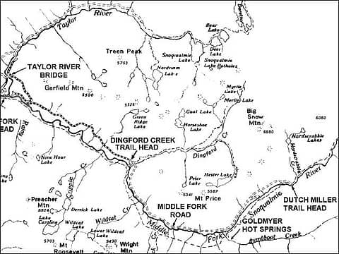 Another MFK Map
|
| Back to top |
|
|
Coasty
I like Salmon!
Joined: 02 Apr 2006
Posts: 762 | TRs | Pics
Location: Kodiak, AK |
|
Coasty
I like Salmon!
|
Sun Jun 03, 2007 1:20 pm |
|
|
Nice Trip report Opus! Glad you guys made it up! I was out on the Mid Fork enjoying the weather last night and thought about driving up there this morning and giving it a shot.. but my wife would have been crazy mad had I not come home this early morning from my overnight.
Jason
|
| Back to top |
|
|
Magellan
Brutally Handsome

Joined: 26 Jul 2006
Posts: 13116 | TRs | Pics
Location: Inexorable descent |
|
Magellan
Brutally Handsome
|
Sun Jun 03, 2007 9:56 pm |
|
|
| Opus wrote: | Oh, hell yeah! |
|
| Back to top |
|
|
Bryan K
Shameless Peakbagger

Joined: 29 Sep 2005
Posts: 5129 | TRs | Pics
Location: Alaska |
|
Bryan K
Shameless Peakbagger
|
Sun Jun 03, 2007 11:11 pm |
|
|
Would biking beyond the gate to the Dutch Miller Gap TH be possible? Or will the FS allow it?
|
| Back to top |
|
|
Allison
Feckless Swooner

Joined: 17 Dec 2001
Posts: 12287 | TRs | Pics
Location: putting on my Nikes before the comet comes |
|
Allison
Feckless Swooner
|
Sun Jun 03, 2007 11:32 pm |
|
|
Reminder that there is an attempt underway to have a Middle Fork End of the Road Campout next weekend. The road is scheduled to close the 20th of June.
More info (not much) here.
www.allisonoutside.com
follow me on Twitter! @AllisonLWoods
www.allisonoutside.com
follow me on Twitter! @AllisonLWoods
|
| Back to top |
|
|
Opus
Wannabe
Joined: 04 Mar 2006
Posts: 3700 | TRs | Pics
Location: The big rock candy mountain |
|
Opus
Wannabe
|
Sun Jun 03, 2007 11:33 pm |
|
|
If it's allowed, you could bike it. It would be a very unpleasant ride I think. It's quite rocky and rough. I'd be exhausted myself just from the bike ride in! Such a shame to lose that great place. I'm really kicking myself for not doing more exploring out in that area.
Ragman's right - that was a hike. I'll certainly be back in the summer ascending from the Dingford creek route.
|
| Back to top |
|
|
Tom
Admin
Joined: 15 Dec 2001
Posts: 17854 | TRs | Pics
|
|
Tom
Admin
|
Sun Jun 03, 2007 11:33 pm |
|
|
You could bike it. 1500 of gain though. Once the road is gated Big Snow would be easier accessed via Dingford Creek. Unlike the rest of the upper MFK, Big Snow will not be put out of reach by the gate.
|
| Back to top |
|
|
|
|


