| Previous :: Next Topic |
| Author |
Message |
naturealbeing
Member


Joined: 05 Dec 2004
Posts: 1565 | TRs | Pics
Location: Great Mystery |
With high ambitions of summiting Dragontail and Colchuck Peaks from the Colchuck Col, three blind mice (Steve F., Coasty, and myself) began their journey at the we hour of 6:30 am.
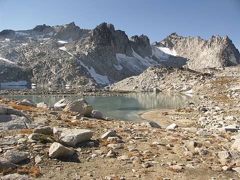
An hour later we reached the turn off to Colchuck Lake and in another hour we were at CL. As we gazed across the lake Dragontail teased us as she moved in and out of the mist. The sky was displaying large areas of blue and everything was shaping up for another super outing. Once we reached the base of the Colchuck Glacier we took a lunch break.
After lunch the boots came out, the crampons on, and the steady march to the col began. Tic toc, tic toc, left foot right foot, tic toc, tic toc, left foot right foot. That was the repeated thyme until the col was reached. By now we had burned up 5-1/2 hrs. of time and our reward was a perfect view to the southwest of a steady stream of clouds and thick fog coming in. It looked like we had competition in our quest and a race to the summit of Dragontail (guess who won?).
Before the race began we had a little pow wow, as to what we wanted to achieve. Now that the summit of DT was cloaked in the clouds, did we want to still give it a go, knowing that viability was 75 yards and even less on the ridge. Well...I made the first move and claimed that I was heading up and by default everyone was soon following me up the S coulior. Tic toc tic toc... you know the drill. This coulior was a bit steeper than Colchuck Glacier and was not a place one would want to test their self arrest skills on, none the less I found it exhilarating in gaining so much elevation in such a short amount of time.
Finally at the top of the coulior what Beckey calls the notch we had the pleasure of the company of Pandora's Box. Now if we could just get this thing open and see what's inside, we might find a cloud/fog/mist vacuum. No such luck. Well...visibility was now down to 50 yards at best and the whole ridge was fog grey.
From a mountaineers report I had read, I remembered one of the images and the comment: "At the ridge there was a pretty big cornice. We set up a fixed line to protect the step over the cornice and the short but exposed class-4 scramble to reach the rock." Well that's where we were and there was a moat there now and on the other side was a rock fin sticking up into the great fog yonder. I was really hoping that the conditions would be different at this time of the year and that a work around would be present. Now, if a person could get onto to the fin and not lose ones balance, one might be able to preform the leap of faith and make it onto solid rock. If not, it sure would be one hell of a ride down a 70 degree slope of hard pack snow. I climbed into the moat with my ice axe and checked out a possible down climb, too skinny, no hand or foot holds, and it look more like a cold storage unit for an unlucky person. Back on top and now looking at down climbing along a rock fin wall on steep snow with uncertainty behind the curtain of fog resulted in the fact that we have gone as far as we could go with out having the necessary equipment to continue.
Slowly and methodically we worked our way down the coulior and with the helping hand of gravity, made it back to the col in one piece.
Once at the col Steve and I thanked Coasty for coming along and wished him a fun and safe journey back. He had to get back to take care of some business.
Now Steve's attention and mine turned to going up Colchuck. This was accomplished in short order and we were greeted with the same views as DT. Well.. not quite, there was a few peek-a-boo views that required no blinking. More fuel, a sign in the register, and down we went. We left the summit at 4 pm and with 700' of scrambling, 2,500' of glissading, we were at the lake in 36 minutes.
Boots off, trail runners on and away we go. The remainder of the trip out was done in a peaceful pace with a dream of king crab legs waiting for me at Kristals. By the time we reached the TH our trip came in at 13 hours, 6200' of gain and about 14-1/2 miles RT.
BTW, if you feel like your missing some color on this report, I'd check out wildernessed's report on Colchuck. He has all the eye candy to keep your sweet eye happy.
|
| Back to top |
  
|
|
wildernessed
viewbagger

Joined: 31 Oct 2004
Posts: 9275 | TRs | Pics
Location: Wenatchee |
Living in the Anthropocene
|
| Back to top |
|
|
wildernessed
viewbagger
Joined: 31 Oct 2004
Posts: 9275 | TRs | Pics
Location: Wenatchee |
I talked to a guy on Colchuck who did the Colchuck Col route to Dragontail three times in the past and was going to do it that day after doing Colchuck. He sais it was class 3 - high class 3. The snow ramp up the back was a steep one with a bone cruncher runout. I think that would have been a trip looking down as you were descending it. I have some pics of the route going from Asgard up Snow Creek Glacier / snowfield which by guidebooks and looks appears more user friendly, that route was rated class 2 when you hit the ridge.
 Good view of Asgard to extreme right, snow creek glacier, Witches Tower to the left, Dragontail Plateau in the background. From the saddle you would gain, turn right and hike class 2 rock up the angled S approach to the summit. 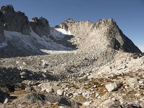 Asgard Pass on right looking up Snow Creek Glacier. 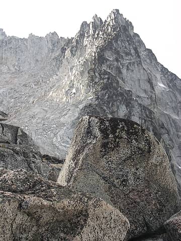 Looking almost directly W from Asgaard Pass at the E ridge terminus of Dragontail.
Living in the Anthropocene
Living in the Anthropocene
|
| Back to top |
|
|
wolfs
Member

Joined: 07 Oct 2004
Posts: 302 | TRs | Pics
|
|
wolfs
Member
|
 Sat Jun 09, 2007 10:31 am |
|
|
I scrambled up Colchuck yesterday (6/8). Conditions are ideal. Took about 9.5 hrs car to car. Won't bother with a new report header; conditions are basically as they were well-pictured in Wilderness' report from 6/2. Can still stay on snow the entire way from Colchuck Lake to the col. I almost brought skis, but in retrospect not sad that I didn't. Although coverage is adequate, only about the top half (starting with the pitch above the moraine) looked good for skiing, although the lobe that goes down closer under the Dragontail cliffs was probably smoother. The part below is cupped, runneled or dirty for skiing purposes but just fine for walking or glissading.
Saw one other party of 2 on the snowfield coming down as I was going up.
Weather was more mostly cloudy than partly sunny (adding one pix for visualization). Crampons useful, although almost an inch was soft at my ascent time of col (around 1-3PM) some of what wasn't soft under steps was pretty icy. Conditions very good for butt glissading, could get purchase both with feet and pick, occasionally a little fast when one's butt found one of those icy patches.
I was amazed how flat Colchuck plateau is. Reminded me of the Enchantment pek plateau just a couple miles away, same innocent looking rock pile turns out to be summit over massive steep wall on other side effect.
I was looking up at that Dragontail route and thinking hmmm looks pretty steep. But that's often true when you get that foreshortened perspective. I've wanted to do the other route but the last time I was up there that Snow Creek Glacier remnant held even more grey than in picture in this thread, and there were scary embedded rocks and schrunds too. Couple years ago in October when I saw conditions like that I set off trying to find the "long" route described in Beckey that goes around the shoulder towards Litttle Annapurna and then cuts back along ridge/plateau for long ways but ended up saying F it and just scrambled Little A instead because it looked fun (and was).
 Stuart from Colchuck 6/8/07
|
| Back to top |
|
|
ActionBetty
Im a dirty hippie!

Joined: 06 Jul 2003
Posts: 4807 | TRs | Pics
Location: kennewick, wa |
|
ActionBetty
Im a dirty hippie!
|
Sat Jun 09, 2007 11:01 am |
|
|
sweetness.. makes me want to climb it just to get the glissade  Hope you had a groovy b-day Richard
"If you're not living good, you gotta travel wide"...Bob Marley
"If you're not living good, you gotta travel wide"...Bob Marley
|
| Back to top |
|
|
naturealbeing
Member
Joined: 05 Dec 2004
Posts: 1565 | TRs | Pics
Location: Great Mystery |
Rob, Thanks for the additional info and pix.
wolfs, Interesting! Last year when you were up there with your (I think) brother, you two got separated and as you were heading down from the lake you passed me by. Now it's a day separation. What are the odds?
Looks like you had a bit higher cloud cover than we did, oh well next time I'm choosing a blue sky day and leaving the grey behind.
ActionBetty, Just do it! Thanks for the kind B D thoughts.
After digging through my pics from the other day, I decided that this post could use some of the color I managed to find. I really had to dig deep too.
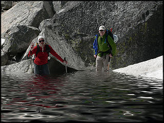 Steve and Coasty experiencing the benefits of being near a lake, 6.7.07. 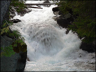 Mountaineers Creek as seen from bridge, 6.7.07. 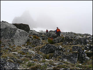 Steve and Coasty decending out of the fog after finishing off the steep decent of the snow packed gully, 6.7.07. 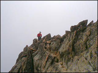 Steve On Colchuck Summit, 6.7.07. 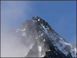 First view of Colchuck Peak from trail to Colchuck Lake, 6.7.07. 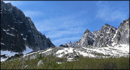 Dragontail & Colchuck Peaks, as seen from SW side of Colchuck Lake, 6.7.07. 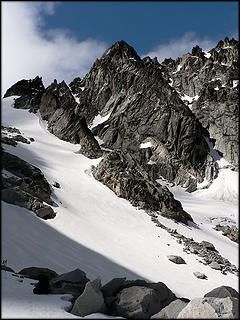 Upper Colchuck Glacier and summit far right, 6.7.07. 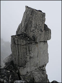 Pandora's Box, as seen from the notch on the W route, S gully of Dragontail, 6.7.07.
|
| Back to top |
|
|
Spotly
Member

Joined: 06 Jan 2004
Posts: 3723 | TRs | Pics
Location: Spokane Valley |
|
Spotly
Member
|
Sun Jun 10, 2007 3:08 pm |
|
|
Did you get back to the TH about 5ish? Here's the lake about 9ish on Saturday: [Added] Never mind - see you were there Thur and not Fri.
|
| Back to top |
|
|
|
|
You cannot post new topics in this forum
You cannot reply to topics in this forum
You cannot edit your posts in this forum
You cannot delete your posts in this forum
You cannot vote in polls in this forum
|
Disclosure: As an Amazon Associate NWHikers.net earns from qualifying purchases when you use our link(s). |


 So did you try Dragontail from Asgard or the Colchuck col side ? What a freaking great glissade , eh !
  Good stuff as usual !


