| Previous :: Next Topic |
| Author |
Message |
Matt
Tea, Earl Grey, Hot


Joined: 30 Jan 2007
Posts: 4307 | TRs | Pics
Location: Shoreline |
|
Matt
Tea, Earl Grey, Hot
|
 Wed Jun 27, 2007 11:32 pm |
|
|
Dates: June 19-21, 2007
Party: Matt, cartman, Yana, Greg
Destination: Forbidden via West Ridge, with camp in Boston Basin
Highlights of the trip:
The Cascade River Road closure added 2.5 miles and 1000 feet of gain to the approach.
The Boston Basin trail is very brushy and annoying.
Boston Basin is still almost completely snow-covered.
The gully up to the West Ridge of Forbidden is snow-filled all the way to the top, but shrunds are developing fast.
Going up the ridge, we used about every possible combination of footwear (crampons, boots, rock shoes) and rope-work (unroped, running belays, belayed climbing, fixed line).
Descending the West Ridge included some of the most awkward diagonal-angled rappels Ive ever done.
Even with 16:09 hours of daylight available, we managed to take over 17:30 hours for the climb.
But if you had to spend hours of time waiting for each other to climb, I can hardly imagine a more magnificient place to do it perched high on a rocky ridge cleaving the sky with spectacular views off both sides on a gorgeous long sunny day.
Forbidden was #90 of the Hundred Highest peaks in Washington for me.
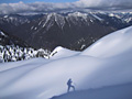
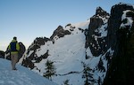
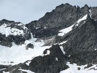 Looking up at Forbidden West Ridge 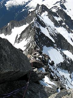 Looking down the west ridge  Climber looking off the false summit 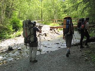 First washout 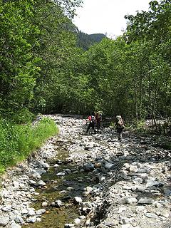 Hiking the river road 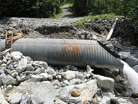 Big culvert in bigger washout 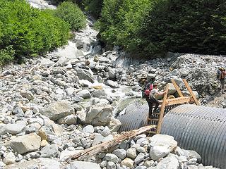 Like a bridge over troubled culverts
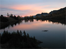
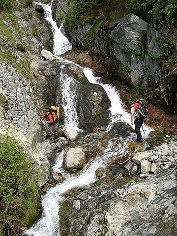 Creek crossing 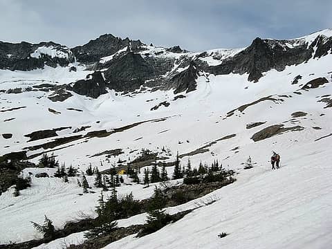 Arriving at Boston Basin 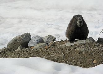 Marmot in Boston Basin 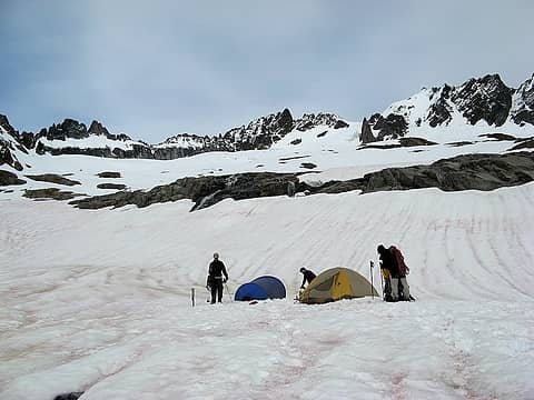 Tents in Boston Basin (Sharkfin, Boston, Sahale above) 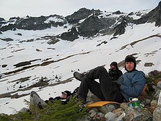 Relaxing after dinner (maybe avoiding looking up at Forbidden) 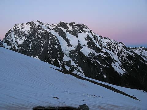 Twilight approaching Johannesburg 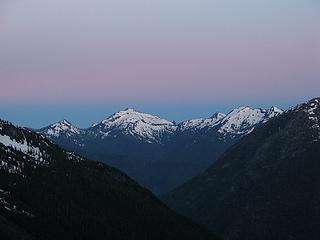 Twilight approaching Hidden Lakes Peaks 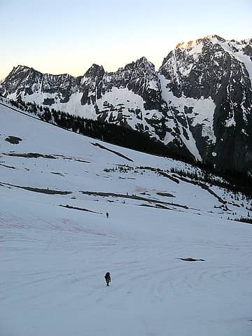 Hiking up out of camp 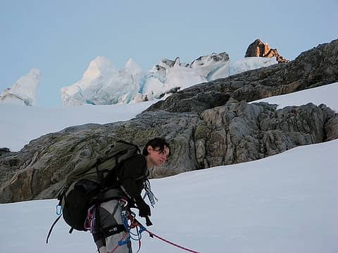 Yana ducking to avoid the debris overhead? 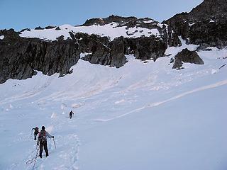 Approaching the gully 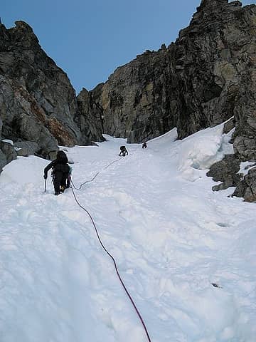 Starting up the gully 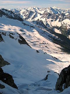 Looking down to shrunds at the bottom of the gully 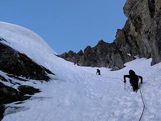 Nearing the top of the gully 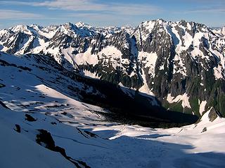 Looking southeast to Boston Basin, Cascade Pass, & beyond 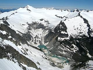 Looking northwest to Morraine Lake & Eldorado 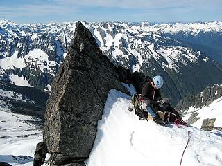 Yana gearing up 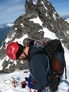 Eric & Greg gearing up 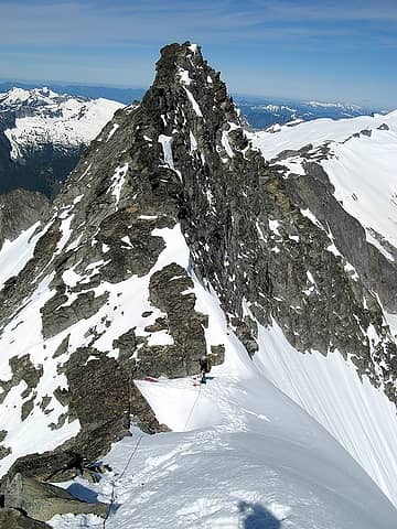 Yana waiting to depart the col
As beacons mountains burned at evening. J.R.R. Tolkien
As beacons mountains burned at evening. J.R.R. Tolkien
|
| Back to top |
  
|
|
Guiran
Member

Joined: 03 Mar 2004
Posts: 621 | TRs | Pics
Location: University of Washington |
|
Guiran
Member
|
Wed Jun 27, 2007 11:40 pm |
|
|
Stay tuned...
Have been waiting for this one for a while, Matt. 
|
| Back to top |
|
|
dicey
custom title

Joined: 11 May 2004
Posts: 2870 | TRs | Pics
Location: giving cornices a wider berth |
|
dicey
custom title
|
Wed Jun 27, 2007 11:42 pm |
|
|
|
| Back to top |
|
|
Tom
Admin
Joined: 15 Dec 2001
Posts: 17851 | TRs | Pics
|
|
Tom
Admin
|
Wed Jun 27, 2007 11:49 pm |
|
|
|
| Back to top |
|
|
Andrew
Member

Joined: 24 Oct 2003
Posts: 1175 | TRs | Pics
Location: Arlington |
|
Andrew
Member
|
Wed Jun 27, 2007 11:50 pm |
|
|
Wowsers! 
|
| Back to top |
|
|
Tazz
Member
Joined: 27 Apr 2005
Posts: 7902 | TRs | Pics
|
|
Tazz
Member
|
Wed Jun 27, 2007 11:51 pm |
|
|
|
| Back to top |
|
|
peltoms
Member

Joined: 13 Jul 2006
Posts: 1760 | TRs | Pics
Location: Worcester MA |
|
peltoms
Member
|
Thu Jun 28, 2007 5:01 am |
|
|
The look back down the west ridge shows the exposure magnificently.  The washouts show just how soon the road is not going to be ready. The washouts show just how soon the road is not going to be ready.
|
| Back to top |
|
|
Magellan
Brutally Handsome

Joined: 26 Jul 2006
Posts: 13116 | TRs | Pics
Location: Inexorable descent |
|
Magellan
Brutally Handsome
|
Thu Jun 28, 2007 6:54 am |
|
|
Thanks for the eye candy, Matt. Most excellent! 
|
| Back to top |
|
|
Yet
Member

Joined: 23 Apr 2005
Posts: 2634 | TRs | Pics
Location: Happily Ever After |
|
Yet
Member
|
Thu Jun 28, 2007 8:08 am |
|
|
Excellent TR and pics, Matt. Always worth the wait.
I was wondering where your summit tea shot was, until I realized you left us with a cliffhanger. Tease.
|
| Back to top |
|
|
Randy
Cube Rat

Joined: 18 Dec 2001
Posts: 2910 | TRs | Pics
Location: Near the Siamangs |
|
Randy
Cube Rat
|
Thu Jun 28, 2007 9:12 am |
|
|
Good stuff Matt. I (like everyone else) want to climb this too.
|
| Back to top |
|
|
wildernessed
viewbagger

Joined: 31 Oct 2004
Posts: 9275 | TRs | Pics
Location: Wenatchee |
Good Stuff, thanks for the read and eye candy. What is nice about this site is that it is inclusive of all types of foot travel along the spectrum of possibilities.
Living in the Anthropocene
Living in the Anthropocene
|
| Back to top |
|
|
pochac
Member

Joined: 06 Jun 2007
Posts: 32 | TRs | Pics
|
|
pochac
Member
|
Thu Jun 28, 2007 9:48 am |
|
|
|
| Back to top |
|
|
payton
Member

Joined: 11 Jul 2006
Posts: 188 | TRs | Pics
|
|
payton
Member
|
Thu Jun 28, 2007 12:30 pm |
|
|
nice TR Thanks for the great description and pics.
|
| Back to top |
|
|
Joe
Member
Joined: 29 Jun 2002
Posts: 819 | TRs | Pics
Location: Kent |
|
Joe
Member
|
Thu Jun 28, 2007 6:21 pm |
|
|
Yana...your pack looks bigger than you  .
I guess you are not in the go lite crowd (me neither, I'm a member of the go heavy crowd .
I guess you are not in the go lite crowd (me neither, I'm a member of the go heavy crowd  ) )
|
| Back to top |
|
|
Layback
Cascades Expatriate
Joined: 16 Mar 2007
Posts: 5712 | TRs | Pics
Location: Back East |
|
Layback
Cascades Expatriate
|
Thu Jun 28, 2007 6:45 pm |
|
|
Very nice stuff you guys. Way jealous that I didn't go... 
|
| Back to top |
|
|
|
|
You cannot post new topics in this forum
You cannot reply to topics in this forum
You cannot edit your posts in this forum
You cannot delete your posts in this forum
You cannot vote in polls in this forum
|
Disclosure: As an Amazon Associate NWHikers.net earns from qualifying purchases when you use our link(s). |


 sweet stuff guys and gal!!! my dream....
  BTW Yana you rock girl!!!