| Previous :: Next Topic |
| Author |
Message |
reststep
Member


Joined: 17 Dec 2001
Posts: 4757 | TRs | Pics
|
|
reststep
Member
|
 Thu Jul 05, 2007 7:36 pm |
|
|
Great trip report. It brings back memories.
Jim, what kind of pack is that you are carrying?
"The mountains are calling and I must go." - John Muir
"The mountains are calling and I must go." - John Muir
|
| Back to top |
  
|
|
JimK
Member

Joined: 07 Feb 2002
Posts: 5606 | TRs | Pics
Location: Ballard |
|
JimK
Member
|
Thu Jul 05, 2007 8:03 pm |
|
|
That's my Golite Gust frameless pack with a Golite Dawn tied on for day hiking. I guessed wrong on the weather and with 5 days of food, half a Hilleberg Nallo 3 tent and a 10 degree sleeping bag I was near the 30 lb. comfortable limit. Lighter camping gear would have been better. By the time the food was gone it was much lighter for the hike out.
|
| Back to top |
|
|
reststep
Member
Joined: 17 Dec 2001
Posts: 4757 | TRs | Pics
|
|
reststep
Member
|
Thu Jul 05, 2007 8:12 pm |
|
|
Interesting, thanks Jim.
"The mountains are calling and I must go." - John Muir
"The mountains are calling and I must go." - John Muir
|
| Back to top |
|
|
Sadie's Driver
Sadie's Driver

Joined: 24 Apr 2006
Posts: 1763 | TRs | Pics
Location: Welcome Pass |
| reststep wrote: | | Interesting, thanks Jim. |
. . . and, he wasn't even carrying the wine!!!  s.d. s.d.
Four-paw buddy lets me tag along!
Four-paw buddy lets me tag along!
|
| Back to top |
|
|
Beave
Member

Joined: 21 Dec 2001
Posts: 276 | TRs | Pics
Location: Woodinville |
|
Beave
Member
|
Fri Jul 06, 2007 12:39 am |
|
|
Nice TR!! I have wanted to explore that area for some time, and this report is definitely inspiration to do so. Cool sunset shot too.
Thanks
|
| Back to top |
|
|
Matt
Tea, Earl Grey, Hot

Joined: 30 Jan 2007
Posts: 4307 | TRs | Pics
Location: Shoreline |
|
Matt
Tea, Earl Grey, Hot
|
Fri Jul 06, 2007 1:48 am |
|
|
| mike wrote: | | Another FWIW:
I think the peak you have called Haig Mtn is the unnamed peak (pt2395m) north of Rock Pk and the Boundary Trail. My map shows Haig several miles farther west and not on the border. If that is border monument 102 in the pictures it would confirm it. elev is about the same as haig too. |
I have to agree with Mike. I'd guess you were on Peak 7845, which has a spur to the border at Point 7491. Still a good summit however. I haven't heard of anyone else whose been to that border obelisk.
Here's what the summit of Haig looks like. The whole crest of the peak makes for great roaming if you leave the trail and go up the east end of the peak.
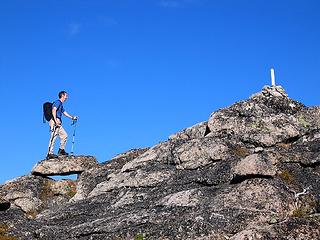 Haig summit 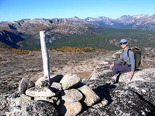 Haig summit looking west to Bauerman & Cathedral 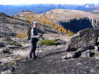 Traveling west along crest of Haig toward Bauerman 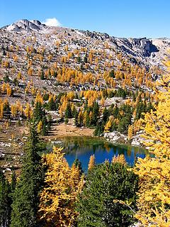 Wonderful "Teapot Lake" tucked between Haig and Bauerman 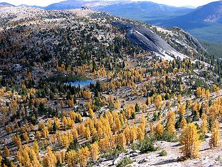 Looking back east from Bauerman to "Teapot Lake," Teapot Dome, and Haig
As beacons mountains burned at evening. J.R.R. Tolkien
As beacons mountains burned at evening. J.R.R. Tolkien
|
| Back to top |
|
|
Matt
Tea, Earl Grey, Hot
Joined: 30 Jan 2007
Posts: 4307 | TRs | Pics
Location: Shoreline |
|
Matt
Tea, Earl Grey, Hot
|
Fri Jul 06, 2007 1:48 am |
|
|
Okay, all these reports from Horseshoe Basin finally provoked me to upload my photos from my Horseshoe Basin Larch Trip, October 2004.
No bugs, beautiful golden larches, 10 summits (Pick, Armstrong, Arnold, Goodenough, Horseshoe, Haig, Teapot, Bauerman, Rock, Windy).
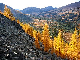 Horseshoe Basin in October
As beacons mountains burned at evening. J.R.R. Tolkien
As beacons mountains burned at evening. J.R.R. Tolkien
|
| Back to top |
|
|
Sadie's Driver
Sadie's Driver
Joined: 24 Apr 2006
Posts: 1763 | TRs | Pics
Location: Welcome Pass |
| Matt wrote: | Okay, all these reports from Horseshoe Basin finally provoked me to upload my photos from my Horseshoe Basin Larch Trip, October 2004.
No bugs, beautiful golden larches, 10 summits (Pick, Armstrong, Arnold, Goodenough, Horseshoe, Haig, Teapot, Bauerman, Rock, Windy).
Horseshoe Basin in October |
Beautiful Larch!!! There are still quite a few on the north approach to Windy Peak - right at the pass and along the route to Topaz. We figured they would be lovely in the Fall - good excuse to go back and REALLY do Haig! (especially with the no bug part!) Thanks.
Four-paw buddy lets me tag along!
Four-paw buddy lets me tag along!
|
| Back to top |
|
|
mike
Member
Joined: 09 Jul 2004
Posts: 6398 | TRs | Pics
Location: SJIsl |
|
mike
Member
|
Fri Jul 06, 2007 11:46 am |
|
|
| Matt wrote: | | Okay, all these reports from Horseshoe Basin finally provoked me to upload my photos from my Horseshoe Basin Larch Trip, October 2004.
No bugs, beautiful golden larches, 10 summits (Pick, Armstrong, Arnold, Goodenough, Horseshoe, Haig, Teapot, Bauerman, Rock, Windy). |
Makes me want to go back and go farther! That Teapot Lk looks like a gem. Unfortunately with the 6hr drive +ferry and adding about 5mi to the 7mi to Louden Lk plus the short days makes it a two day trip in for me. But who needs to work?
|
| Back to top |
|
|
Sadie's Driver
Sadie's Driver
Joined: 24 Apr 2006
Posts: 1763 | TRs | Pics
Location: Welcome Pass |
| dusty boots wrote: | | Great TR and pics, SD ! This area was on my 'to do' list but was told earlier in the year that the area had been burned over. |
Dusty - FYI - there was reported this morning (07-08-07) a 1000 acre fire near Nighthawk. Hope it doesn't spread into the Pasayten. 
Four-paw buddy lets me tag along!
Four-paw buddy lets me tag along!
|
| Back to top |
|
|
dusty boots
' Gimp '

Joined: 28 Mar 2005
Posts: 199 | TRs | Pics
Location: Haunting the Okanagan Highlands, B.C. Canada |
it should be right around that next bend........I think.....
|
| Back to top |
|
|
JimK
Member
Joined: 07 Feb 2002
Posts: 5606 | TRs | Pics
Location: Ballard |
|
JimK
Member
|
Wed Jul 18, 2007 5:37 pm |
|
|
Well, it took me a few weeks but I now have 85 photos posted along with my report. I have a few that show the extent of the burn. Enjoy.
Horseshoe Basin Report and Photos
|
| Back to top |
|
|
twodogdad
Member
Joined: 21 Nov 2006
Posts: 846 | TRs | Pics
Location: seattle |
|
twodogdad
Member
|
Thu Jul 19, 2007 1:18 pm big burn
|
|
|
I went to Windy Pk the following week and then drove FR39 from Iron Gate to Winthrop: it's about 50 miles of burn-- 360 degrees as far as eye can see: ghostly, unreal--especially when you spot a green tree in the midst of the burn, mysteriously spared--often strangely beautiful.
One of my goals was Amphitheater/Apex but I got lost in the Tungsten Creek area: one of the books I followed says Tungsten Cr Trail is unmarked and starts at a small meadow right before crossing the river on two one-log planks. I found the spot and followed a couple of faint paths which led me deeper and higher into the wilderness--and into very tight spots up the canyon walls of two creeks; I was hoping I could reach Boundary Tr by scrambling North but eventually we hit a big cliffy drop and had to retrace our steps, chastised. The trail to Remmel looked OK and I was tempted but I'd run low on dog food so I left Remmel for another outing. So I changed my plan, got back to Cathedral Cr TH, drove N to Iron Gate, and then hiked to Arnold and Windy (area N from Sunny Pass is exquisite).
Hi Adrianne & Todd and thanks for feeding the hungry: hope you made it to Cathedral. tdd
|
| Back to top |
|
|
|
|
You cannot post new topics in this forum
You cannot reply to topics in this forum
You cannot edit your posts in this forum
You cannot delete your posts in this forum
You cannot vote in polls in this forum
|
Disclosure: As an Amazon Associate NWHikers.net earns from qualifying purchases when you use our link(s). |


 Geese, here we go again!


 Hopefully that will be under control soon as that is close to both the PW and to Cathedrals PP, which I was also planning on doing as well, in less than a month.
A fire that close would definitely impact on 'the views' due to smoke etc., never mind the constant drone of aircraft/helicopters.
Hopefully that will be under control soon as that is close to both the PW and to Cathedrals PP, which I was also planning on doing as well, in less than a month.
A fire that close would definitely impact on 'the views' due to smoke etc., never mind the constant drone of aircraft/helicopters.  We'll have to keep an eye on things and make a 'judgement call' nearer the time.
Thanks again, Dusty
We'll have to keep an eye on things and make a 'judgement call' nearer the time.
Thanks again, Dusty