| Previous :: Next Topic |
| Author |
Message |
yew
non-technical


Joined: 12 Dec 2005
Posts: 1173 | TRs | Pics
Location: Bellingham |
|
yew
non-technical
|
 Mon May 14, 2007 8:12 pm |
|
|
The Wells Creek Rd (FR 33) is gated just beyond Nooksack Falls and that's where this trip began. I wanted to check this road out to see if it was washed-out to the Cougar Divide trailhead (Hike #7 in Manning & Springs 100 Hikes in Washingtons North Cascades
) since Manning wrote, As for the road, what with no more logging hereabouts, it gets less maintenance every year and thus gets meaner every year. I wanted to see how mean it is in 2007. This route is also Trip #4 in the 1988 edition of Kirkendall & Spring's "Cross Country Ski Tours 1: Washington's North Cascades"
The gate opens July 1st. I dont why the gate is closed until July 1st. Elk habitat? About 3 times I had to dismount the bike to step over larger blowdowns with many small ones that could be ridden over. There was a little avalanche material over road at bottom of one of Barometer Mountains chutes.
The Forest Service did a lot of bridge and culvert work on this road last summer. Thankfully, the new bridges and culverts did not get washed out by The Nov. 06 Storm or any other nasty storms.
 wells creek near Mt Baker 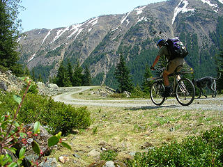 Mountain biking the Wells Creek Rd with skis attached. Barometer Mountain from Wells Creek Rd near Mt Baker  botched self-timer on Wells Creek Rd spring ski, near Mt Baker, Washington. Skiing in shorts in the sun is nice. Mt Baker from upper Wells Creek Rd Wells Creek waterfalls small cave near Wells Creek
"I aint jokin woman, I got to ramble...We gonna go walkin through the park every day." - Led Zeppelin
"I aint jokin woman, I got to ramble...We gonna go walkin through the park every day." - Led Zeppelin
|
| Back to top |
  
|
|
Sore Feet
Member

Joined: 16 Dec 2001
Posts: 6307 | TRs | Pics
Location: Out There, Somewhere |
Sweet! The Wells Creek culvert was finally replaced! Methinks some Baker romping will be in order this year.
By any chance, you don't happen to have any photos looking up the Wells Creek drainage from near that last switchback before the trailhead, do you?
|
| Back to top |
|
|
yew
non-technical
Joined: 12 Dec 2005
Posts: 1173 | TRs | Pics
Location: Bellingham |
|
yew
non-technical
|
Tue May 15, 2007 7:57 pm pic of Wells Creek drainage
|
|
|
Sore Feet:
I do have a photo of the Wells Creek drainage above FR 33 but the snow on the mountains are washed out and the bottom is not in the pic. Hope this helps. The angle isn't very good.
Wells Creek drainage from upper FR 33
"I aint jokin woman, I got to ramble...We gonna go walkin through the park every day." - Led Zeppelin
"I aint jokin woman, I got to ramble...We gonna go walkin through the park every day." - Led Zeppelin
|
| Back to top |
|
|
jenjen
Moderatrix

Joined: 30 Jun 2003
Posts: 7617 | TRs | Pics
Location: Sierra stylin |
|
jenjen
Moderatrix
|
Tue May 15, 2007 8:56 pm |
|
|
Having that culvert intact is such great news. I feel a Cougar Divide trip coming on, w00t!
If life gives you melons - you might be dyslexic
If life gives you melons - you might be dyslexic
|
| Back to top |
|
|
peltoms
Member

Joined: 13 Jul 2006
Posts: 1760 | TRs | Pics
Location: Worcester MA |
|
peltoms
Member
|
Wed May 16, 2007 2:43 pm |
|
|
Nice reconnaisance. Good pics of Wells Creek Falls looks like a lower water flow day than I am used to seeing.
|
| Back to top |
|
|
Sore Feet
Member
Joined: 16 Dec 2001
Posts: 6307 | TRs | Pics
Location: Out There, Somewhere |
Wow. Concrete reinforced culvert even. Thanks for that other pic, thats exactly what I was looking for.
|
| Back to top |
|
|
Scrooge
Famous Grouse

Joined: 16 Dec 2001
Posts: 6966 | TRs | Pics
Location: wishful thinking |
|
Scrooge
Famous Grouse
|
Wed May 16, 2007 6:34 pm |
|
|
Thank Yew. That's a first class report.
I've had Cougar Divide on my list ever since ....... about two months before that danged washout.  But Sore Feet is right, that looks like a serious repair job, like maybe they intended to keep the road open.
As for the slide, if the outside edge of the road wasn't damaged, it looks like the kind of thing that a little "unauthorized" maintenance will clear a path through. ....... I hope so. I like being able to drive as far as possible.
Fingers crossed: Cougar Divide is now on my list for 2007. But Sore Feet is right, that looks like a serious repair job, like maybe they intended to keep the road open.
As for the slide, if the outside edge of the road wasn't damaged, it looks like the kind of thing that a little "unauthorized" maintenance will clear a path through. ....... I hope so. I like being able to drive as far as possible.
Fingers crossed: Cougar Divide is now on my list for 2007. 
Something lost behind the ranges. Lost and waiting for you....... Go and find it. Go!
Something lost behind the ranges. Lost and waiting for you....... Go and find it. Go!
|
| Back to top |
|
|
yew
non-technical
Joined: 12 Dec 2005
Posts: 1173 | TRs | Pics
Location: Bellingham |
|
yew
non-technical
|
Thu May 17, 2007 8:54 am the rock slide on upper portion
|
|
|
| Quote: | | As for the slide, if the outside edge of the road wasn't damaged, it looks like the kind of thing that a little "unauthorized" maintenance will clear a path through. ....... I hope so. I like being able to drive as far as possible. |
Yeah, same here. If I'm hiking, I want it to be on trail or bushwhack, not on a gravel road.
There was snow on the road so I could not tell if a little citizen-initiated road maintenance would make that stretch passable to cars. Either way, somebody would have to roll some boulders and big rocks. A Jeep or another narrow, high-clearance 4WD vehicle may be able to make it through with some rock relocation work. The outside/downhill road rim looked a little soft and mushy due to soggy clay soil.
"I aint jokin woman, I got to ramble...We gonna go walkin through the park every day." - Led Zeppelin
"I aint jokin woman, I got to ramble...We gonna go walkin through the park every day." - Led Zeppelin
|
| Back to top |
|
|
treebugger
Member

Joined: 19 May 2004
Posts: 32 | TRs | Pics
|
I've got two strong hands...I can help.
|
| Back to top |
|
|
Sore Feet
Member
Joined: 16 Dec 2001
Posts: 6307 | TRs | Pics
Location: Out There, Somewhere |
Little update here - Road 33 is rough, rougher and rougherest in the climb past the Bar Creek bridge. I made it to within about 2 1/2 miles of the Cougar Divide TH and opted to turn around because going up was hairy enough, I didn't want to come down that in the dark. Fine just fine up to Bar Creek. High clearance recommended until the FS decides to grade it all the way up (though I have a feeling they only maintain it to Bar Creek because theres a stream gauge there).
|
| Back to top |
|
|
marionthegoat
That's a trail ??

Joined: 29 May 2007
Posts: 240 | TRs | Pics
Location: Ferndale, WA |
| Sore Feet wrote: | | Little update here - Road 33 is rough, rougher and rougherest in the climb past the Bar Creek bridge. I made it to within about 2 1/2 miles of the Cougar Divide TH and opted to turn around because going up was hairy enough, I didn't want to come down that in the dark. |
Thanks for the update ! Hairy ?  Not to be a pest, but hairy how ? Brush ? Narrow or collapsed grade ? too steep ? or just lots of big bumps and rocks ? I aim to be there in Sept, just curious. Not to be a pest, but hairy how ? Brush ? Narrow or collapsed grade ? too steep ? or just lots of big bumps and rocks ? I aim to be there in Sept, just curious. 
|
| Back to top |
|
|
Sore Feet
Member
Joined: 16 Dec 2001
Posts: 6307 | TRs | Pics
Location: Out There, Somewhere |
Lotta big rocks, a few places where there has been noticeable water scouring right down the road, revealing even bigger rocks. Brush is encroaching a bit, but its not bad. Couple water bars that might be probematic for lower clearance cars (mine made it over fine). Its basically a 5mph road starting about 1/2 mile above Bar Creek.
|
| Back to top |
|
|
|
|


