| Previous :: Next Topic |
| Author |
Message |
Flora
Enjoying the Sun!


Joined: 25 Mar 2007
Posts: 1035 | TRs | Pics
Location: Land of many waters |
|
Flora
Enjoying the Sun!
|
 Wed Aug 01, 2007 2:26 pm |
|
|
Hi guys! Back from a trip to Bellingham. The fire I was referring to was in the drainage of the West Fork White. It was not a part of the Coplay fire on the other side of the Clearwater, near the Summit Lake TH. There were a lot of little fires around last summer!
I'm moving to B-ham soon. Got a job at the hospital there so my outdoor focus is going to be changing...From Mt. Rainier to Mt. Baker, etc.
Enjoy the warm weather!
Flora
|
| Back to top |
  
|
|
Kathleen
Member
Joined: 14 Feb 2007
Posts: 220 | TRs | Pics
Location: Tacoma, Washington |
|
Kathleen
Member
|
Fri Aug 03, 2007 9:36 pm |
|
|
| MCaver wrote: | | MCaver wrote: | | Other than an eternally shut gate on SR-410 |
Just FYI, I wasn't referring to the FS-74 juntion to SR-410, but the one directly across the highway from FS-70. It leads to a network of roads that run along the west bank of the WFK White River and ultimately connect to FS-74 way upstream, potentially bypassing the washouts. I've never seen this gate open, however, probably because of it's proximity to the Seattle municipal watershed. |
I always have wondered about that gate every time I come back out FS 70 to the highway.
|
| Back to top |
|
|
mr_woodsy
Member

Joined: 06 Aug 2006
Posts: 6 | TRs | Pics
|
| Kathleen wrote: | | MCaver wrote: | | MCaver wrote: | | Other than an eternally shut gate on SR-410 |
Just FYI, I wasn't referring to the FS-74 juntion to SR-410, but the one directly across the highway from FS-70. It leads to a network of roads that run along the west bank of the WFK White River and ultimately connect to FS-74 way upstream, potentially bypassing the washouts. I've never seen this gate open, however, probably because of it's proximity to the Seattle municipal watershed. |
I always have wondered about that gate every time I come back out FS 70 to the highway. |
I bet that gate's been closed for a good 15 years now. it used to cross the White River and meet up with the Weyerhauser mainline. The mainline crossed back over to the 74 side of the river but was just barely upstream.
if you get on the 74 and go through the houses just past the gate there's a road that goes to the right. thats where the mainline used to come out at.
And it's no where near the Seattle watershed. Isn't even close to the Tacoma watershed. The nearest town to the Seattle watershed is North Bend (on the south side of I-90) and the Tacoma watershed starts at the top of the mountains on the North side of the valley and contains the Green River's watershed.
|
| Back to top |
|
|
Flora
Enjoying the Sun!
Joined: 25 Mar 2007
Posts: 1035 | TRs | Pics
Location: Land of many waters |
|
Flora
Enjoying the Sun!
|
Sat Aug 11, 2007 9:24 pm |
|
|
Some of those lands are the White River Tree Farm, too, which was owned by Weyerhauser, but now some Eastern dudes who are strip mining the slopes.
|
| Back to top |
|
|
mr_woodsy
Member
Joined: 06 Aug 2006
Posts: 6 | TRs | Pics
|
There might be some FS land checkerboarded in there but almost all of the land that low is Hancock. I've heard they tend to strip mine the hills right after a large purchase to help pay down the debt they've accumulated. I've noticed they're taking whatever trees they can that are close to the road and quick to market.
Hopefully once they pay the debt down they'll slow down the harvest.
They shut that gate when they shut down the rest of the tree farm, can't say as I blame them, if people were doing that to my land I'd have closed it long before they did. If you have one of their passes you should be able to get onto the mainline down where the mill used to be and drive up the mainline that far unless it's had washouts as well.
|
| Back to top |
|
|
MCaver
Founder

Joined: 14 Dec 2001
Posts: 5124 | TRs | Pics
|
|
MCaver
Founder
|
Sat Aug 11, 2007 10:47 pm |
|
|
| mr_woodsy wrote: | | And it's no where near the Seattle watershed. |
I must have been looking at the wrong connecting map because you are correct, it's nowhere near there. 
|
| Back to top |
|
|
Phobos
Phobos
Joined: 12 Nov 2018
Posts: 9 | TRs | Pics
Location: Clearwater Wilderness |
|
Phobos
Phobos
|
Mon Jul 29, 2019 12:16 pm |
|
|
When is the last time you checked the condition of 7550? I'm looking use 7550 to access the park, and link up with the NBT.
|
| Back to top |
|
|
HikerJohn
Member

Joined: 01 Sep 2008
Posts: 354 | TRs | Pics
Location: Daydreaming |
I'll have to doublecheck, but I think you'd be hard pressed to get to the Park via 7550.
As has been said before, the 74 road is out all the way back near SR410, so you'd have to come in via the 73 road. You still can get to Lonesome Lake via that route, and you can get down to the West Fork, but there is a deconstruction project going on right now where they are decommissioning the bridge over the West Fork that used to lead to Martin Gap.
There is an old spur that runs along the river towards the park, but I THINK it was decommissioned a few years back.
|
| Back to top |
|
|
Sore Feet
Member

Joined: 16 Dec 2001
Posts: 6307 | TRs | Pics
Location: Out There, Somewhere |
If, and this is a big if, the imagery on Google Earth is up to date (it's dated about a year ago), it might be possible to get about a mile down 7550 before encountering the first washout. The FS website says there's a gate at the mile mark on 7550, so that jives with the first washout. It almost looks like it'd be bikeable beyond there for a couple miles though (there's another washout though). Worst case scenario, maybe a 3 mile hike to the park boundary.
|
| Back to top |
|
|
Phobos
Phobos
Joined: 12 Nov 2018
Posts: 9 | TRs | Pics
Location: Clearwater Wilderness |
|
Phobos
Phobos
|
Wed Jul 31, 2019 9:13 am |
|
|
Yeah I'll have to use 75 till I reach the road closure at the 74 junction. I'll be scouting it out soon, especially the bridge condition. Fell trees have been used in the past to cross the river, I'll check to see if they are still place.
I was at Martin Gap last year from Cedar Lake TH, will take two days hiking to reach Clear West Peak from that direction.
I'll also be checking out 7550, to see how much has been washed away. I hope its still usable to enter RNP.
|
| Back to top |
|
|
Phobos
Phobos
Joined: 12 Nov 2018
Posts: 9 | TRs | Pics
Location: Clearwater Wilderness |
|
Phobos
Phobos
|
Sat Aug 03, 2019 8:49 pm |
|
|
Went to the FS Road 74 bridge over WFWR. Major construction effort, with lots of heavy equipment. They have a road built all the way to the bridge, and another going upstream. A temp damn has been constructed upstream, to reroute the river around the remaining bridge.
So with the amount of money getting spent, I assume its not just to remove a free standing bridge that cant be accessed. My guess is logging is planned for the other side of the river, requiring bridge repair/replacement. If you want a pic, message me.
|
| Back to top |
|
|
HikerJohn
Member
Joined: 01 Sep 2008
Posts: 354 | TRs | Pics
Location: Daydreaming |
| Phobos wrote: | | I assume its not just to remove a free standing bridge that cant be accessed. My guess is logging is planned for the other side of the river, requiring bridge repair/replacement. |
Nope-- due to salmon concerns, they are removing the bridge and all the concrete abutments in the river. Plan is to have it complete by end of September.
Not sure what the plan is for the rest of the 74 road network, but guessing they'll just let is "self-decommission"... a lot of it already has on the west side of the river due to the washouts. Wish they'd figure out a way to turn that into mountain bike land...
|
| Back to top |
|
|
Phobos
Phobos
Joined: 12 Nov 2018
Posts: 9 | TRs | Pics
Location: Clearwater Wilderness |
|
Phobos
Phobos
|
Tue Aug 06, 2019 9:42 am |
|
|
Ok. Ill back in a couple weeks. Will
Be interesting to check on their progress.
Well with no bridge.... I have seen a lot of work on the Weyerhaeuser Mainline road along 410. So maybe they plan on extending a road near the Palisades. Id surprised if they cut off and dont harvest the forest in that area.
I plan to hike those roads in the fall. I was at the Martin Gap parking lot last summer. Looked like a grassy field, but no damage or fell.
|
| Back to top |
|
|
lopper
off-route

Joined: 22 Jan 2002
Posts: 845 | TRs | Pics
|
|
lopper
off-route
|
Tue Aug 06, 2019 4:26 pm |
|
|
Hiker John wrote:
"Wish they'd figure out a way to turn that into mountain bike land..."
Agreed!
But until then.....
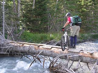 WFKWhite1
|
| Back to top |
|
|
HikerJohn
Member
Joined: 01 Sep 2008
Posts: 354 | TRs | Pics
Location: Daydreaming |
Ok, talked to USFS bosses yesterday and confirmed:
- W. Fork bridge is being removed, including all concrete that could impact the stream
- Roads on the west side of the bridge will be allowed to deteriorate (effectively "self-decommission") as they will no longer be accessible
- There is no plan for a footbridge or anything across the river
- The contractor is even pulling up asphalt back to the junction with FS75
- 7550 is gated and hasn't been driven in a while, so no good ideas of it's condition
So there's some good intel!
|
| Back to top |
|
|
|
|


