| Previous :: Next Topic |
| Author |
Message |
Matt
Tea, Earl Grey, Hot


Joined: 30 Jan 2007
Posts: 4307 | TRs | Pics
Location: Shoreline |
|
Matt
Tea, Earl Grey, Hot
|
 Sat Aug 18, 2007 12:53 am |
|
|
Dates: August 8-10, 2007
Party: Matt, Greg L (gregor)
Destination: Tupshin (8320) & Devore (8360) via Devore Creek & Bird Creek
This trip ascended Tupshin & Devore from Bird Creek Camp on the Devore Creek trail. We had planned to climb each peak on a separate day via the standard but brushy Bird Creek approach. Instead, we were able to make a loop that avoided Bird Creek and climbed both summits in a single day.
* Tupshins summit was a straightforward face of ledges and clefts to thread upward.
* Devores summit was a longer ridge of obstacles and false summits to weave around.
* To get there, we dodged upward through brush, splashed around in lakes, and stumbled downward over talus.
* Along the way, fires smoked, creeks sang, and flowers smiled.
Summit Day, Short version:
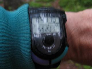 6am, 4150 feet, Bird Creek Camp 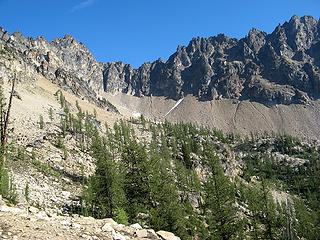 9am, 6900 feet, First view of Tupshin from ridge crest 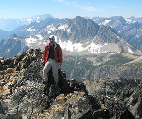 11:10am, 8320 feet, Tupshin Summit (93/100), looking ahead to Devore 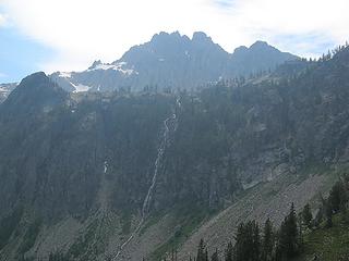 2:25pm, 6400 feet, Traversing to Devore waterfall 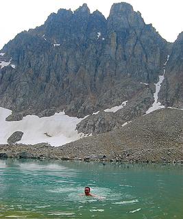 3:30pm, 7000 feet, Devore Lake 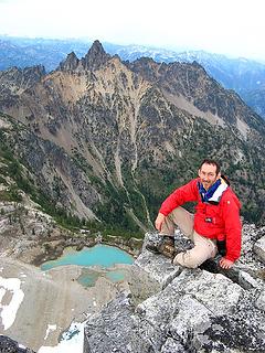 5:45pm, 8360 feet, Devore Summit, (94/100), looking back to Tupshin 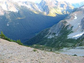 7pm, 7600 feet, beginning descent of West Fork Devore Creek 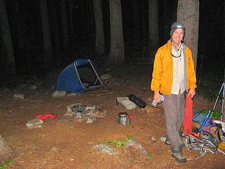 10pm, 4150 feet, Bird Creek Camp 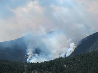 Domke Fire 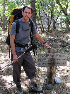 Greg at the Devore Creek Trailhead 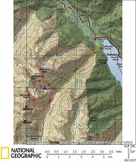 Tupshin & Devore Approach Map Yellow line is approach hike. White line is unused hike from Harlequin bridge. Red lines are summit routes. 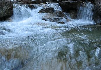 Singing Water 1 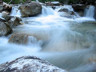 Singing Water 2 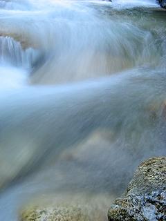 Singing Water 3 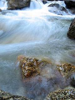 Singing Water 4 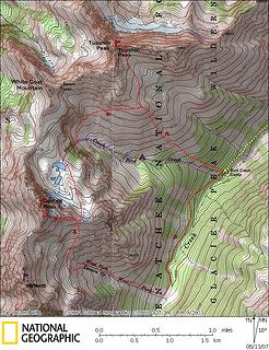 Tupshin & Devore summit map. Red line is our route. Purple line is standard route up Bird Creek. 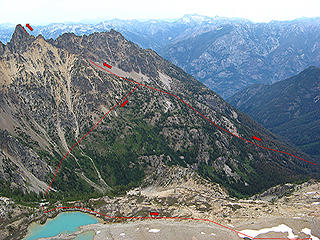 Annotated photo of our route up Tupshin and then to Devore Lakes (taken from Devore) 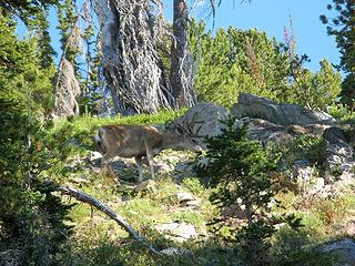 Deer amid light brush on approach to Tupshin Tupshin from 6900 foot ridge crest 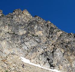 Tupshin summit 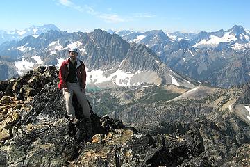 Matt on Tupshin summit 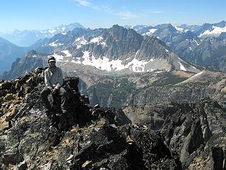 Greg on Tupshin summit 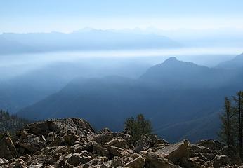 Smoke clouds eastward 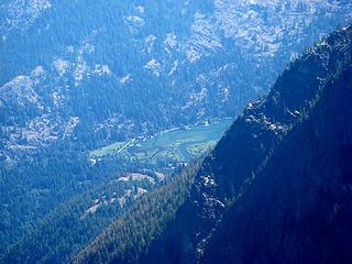 Stehekin River delta at head of Lake Chelan 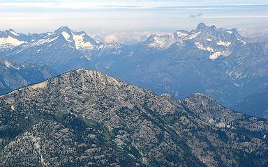 Buckner, Park Creek Pass, & Goode, our location three weeks ago 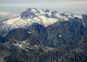 Sinister & Dome, but whats in the foreground? 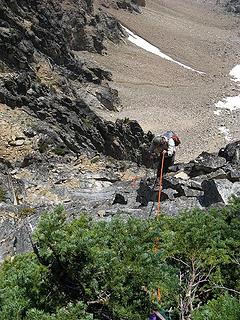 Greg rappelling on his pretty new orange rope 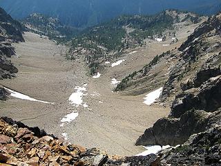 Looking down to the basin below Tupshin, divider ridge is at right Bird Creek waterfall below the Devore Lakes Basin. Route is in greenery about halfway between waterfall and righthand edge of photo. 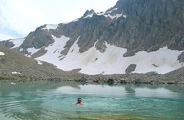 Swimming in Devore Lake. 7500 col at left, Bottles in center 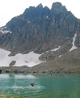 Swimming to Devore. False summit & summit above. 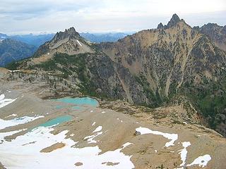 View from 7500 col. Devore Lakes, White Goat, & Tupshin. 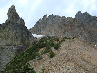 Greg approaching The Bottles 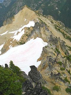 View of col & Bottles from false summit 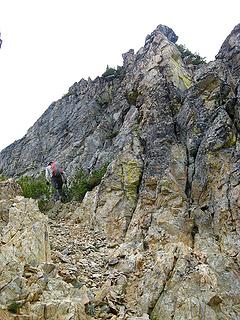 Bypassing obstacles em route to false summit. 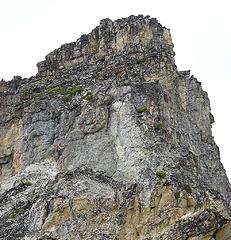 Greg on the step below the false summit 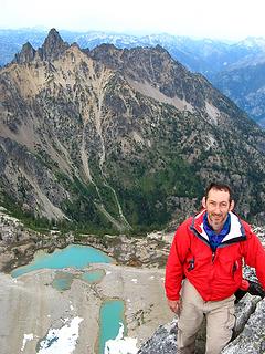 Matt on Devore summit 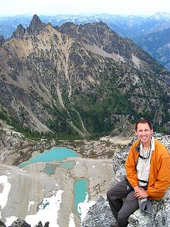 Greg on Devore summit 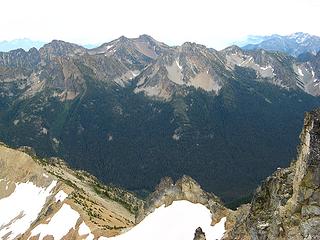 Castle & Flora 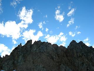 Clouds above Devore 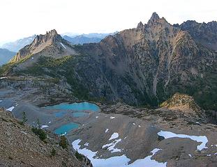 Devore Lakes, White Goat, & Tupshin 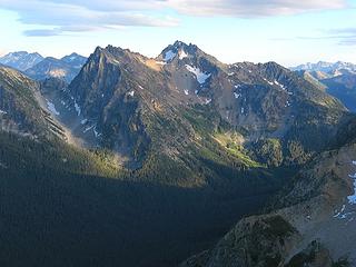 Riddle Peak above the head of Devore Creek West Fork Devore valley from 7500 col 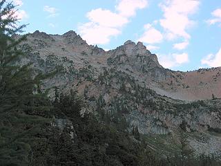 Looking back up to Tupshin from the south side 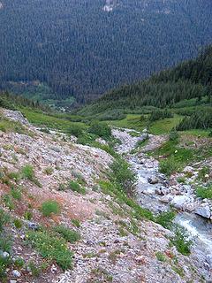 West Fork Devore Creek circa 6300 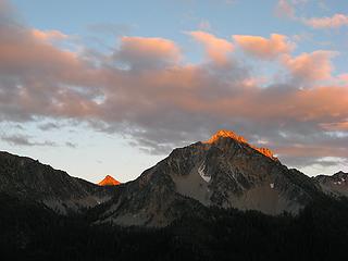 Last light on the summits above 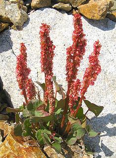 Flowers amid the rocks below Tupshin 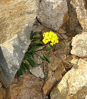 Flowers amid the rocks below Tupshin 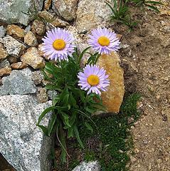 Flowers amid the rocks on Devore 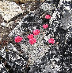 Flowers amid the rocks on Devore 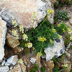 Flowers amid the rocks on Devore 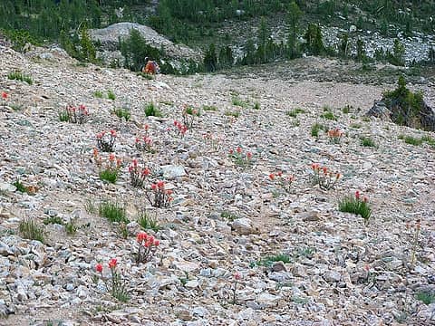 Orange paintbrush amid talus 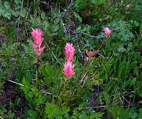 Pink paintbrush in the lower brush 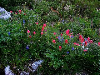 Paintbrush & lupine near the creek bed 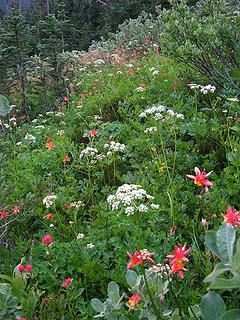 Columbine on the hillside 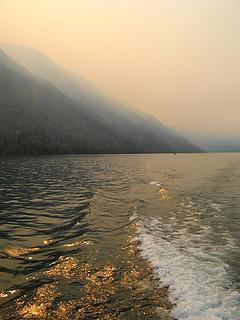 Smoke on the water 1 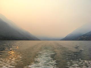 Smoke on the water 2 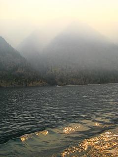 Smoke on the water 3 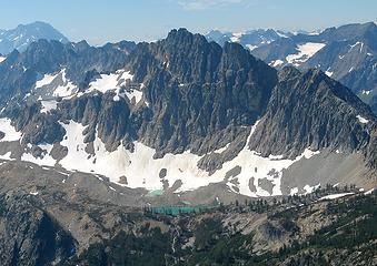 Devore Lakes from Tupshin 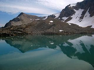 Lakeside view 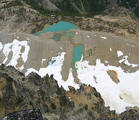 Devore Lakes from Devore 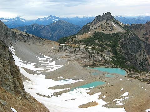 Devore Lakes & White Goat
As beacons mountains burned at evening. J.R.R. Tolkien
As beacons mountains burned at evening. J.R.R. Tolkien
|
| Back to top |
  
|
|
Magellan
Brutally Handsome

Joined: 26 Jul 2006
Posts: 13116 | TRs | Pics
Location: Inexorable descent |
|
Magellan
Brutally Handsome
|
Sat Aug 18, 2007 10:55 am |
|
|
|
| Back to top |
|
|
wildernessed
viewbagger

Joined: 31 Oct 2004
Posts: 9275 | TRs | Pics
Location: Wenatchee |
 Nice stuff as usual. Anyone have a cigarette ? Nice stuff as usual. Anyone have a cigarette ?
Living in the Anthropocene
Living in the Anthropocene
|
| Back to top |
|
|
Mesahchie Mark
A Lerxst

Joined: 10 May 2005
Posts: 700 | TRs | Pics
Location: In Wonderland |
Nice! So, with only 6 to go, what's left, Matt? Also, which "list" are you using (I understand there's some conflict when it comes to prominence)?
|
| Back to top |
|
|
Yet
Member

Joined: 23 Apr 2005
Posts: 2634 | TRs | Pics
Location: Happily Ever After |
|
Yet
Member
|
Sat Aug 18, 2007 6:00 pm |
|
|
| Matt wrote: | | Ive been trying to actually publish a complete TR all at once for a change, but Im just too slow and people have been asking about this trip, so heres the short version. There was more interesting stuff along the way, so I hope to have the rest of the report soon. Along with finishing some even better stuff from the Goode TR, and publishing the Gabriel TR that's still unfinished from June, etc. |
Sounds like you need an assistant! 
|
| Back to top |
|
|
summitseeker
Member

Joined: 31 Mar 2006
Posts: 138 | TRs | Pics
Location: Seattle |
Awesome work guys! That's a BIG day. Those are two remote and wonderful peaks. Not many ascents, but they seem to be growing in popularity -- well, relatively speaking. I've posted a link to your TR on my website.
"Find out who you are and then do it on purpose."
www.summitroutes.com : Guidebook to the 100 highest peaks in Washington
"Find out who you are and then do it on purpose."
www.summitroutes.com : Guidebook to the 100 highest peaks in Washington
|
| Back to top |
|
|
Matt
Tea, Earl Grey, Hot
Joined: 30 Jan 2007
Posts: 4307 | TRs | Pics
Location: Shoreline |
|
Matt
Tea, Earl Grey, Hot
|
Fri Aug 24, 2007 1:29 am |
|
|
I finally finished the rest of the report and edited it into the original post.
| Yet wrote: | | Sounds like you need an assistant! |
Actually I mostly need an editor to keep me focussed.
| Mesahchie Mark wrote: | | Nice! So, with only 6 to go, what's left, Matt? Also, which "list" are you using (I understand there's some conflict when it comes to prominence)? |
I'm referring to the Bulger Top 100 list. Since it was the original list, I think it's appropriate to finish everything on their list before claiming to have matched their accomplishment. My remaining summits are Azurite, Bonanza, Clark, Luahna, Sherpa & Colchuck. I'd like to still squeeze in Azurite this September if I can recruit any companions. Bonanza will be next July. Colchuck will be last, since it's most accessible for a party on the summit.
However, the Bulger list includes some peaks that aren't legitimate distinct summits, becuase they include named summits that lack prominence. Therefore overall I prefer summitseeker's list, which goes solely by prominence. By that list, I'm at 92/100, and I also need to finish Ballard and Castle. If weather allows, I want to do Castle in late September as a larch trip.
As beacons mountains burned at evening. J.R.R. Tolkien
As beacons mountains burned at evening. J.R.R. Tolkien
|
| Back to top |
|
|
Backpacker Joe
Blind Hiker

Joined: 16 Dec 2001
Posts: 23956 | TRs | Pics
Location: Cle Elum |
Bugger, Matt I thought those were called the "Bird lakes"?
Nice work.
"If destruction be our lot we must ourselves be its author and finisher. As a nation of freemen we must live through all time or die by suicide."
Abraham Lincoln
"If destruction be our lot we must ourselves be its author and finisher. As a nation of freemen we must live through all time or die by suicide."
Abraham Lincoln
|
| Back to top |
|
|
Matt
Tea, Earl Grey, Hot
Joined: 30 Jan 2007
Posts: 4307 | TRs | Pics
Location: Shoreline |
|
Matt
Tea, Earl Grey, Hot
|
Fri Aug 24, 2007 8:58 am |
|
|
BPJ,
If you say they're called Bird Lakes, then I'm sure they are. Makes sense, since they're at the head of Bird Creek.
I confess to just calling them "Devore Lakes" out of convenience, since I didn't want to type "the lakes on the north side of Devore" every time.
As beacons mountains burned at evening. J.R.R. Tolkien
As beacons mountains burned at evening. J.R.R. Tolkien
|
| Back to top |
|
|
Gil
Member

Joined: 29 Sep 2004
Posts: 4062 | TRs | Pics
|
|
Gil
Member
|
Fri Aug 24, 2007 9:49 am |
|
|
Looks like a great trip!
Friends help the miles go easier.
Klahini
Friends help the miles go easier.
Klahini
|
| Back to top |
|
|
Sabahsboy
Member

Joined: 18 Jul 2006
Posts: 2484 | TRs | Pics
Location: SW Sno County |
|
Sabahsboy
Member
|
Fri Aug 24, 2007 9:56 am Tupshin and Devore
|
|
|
Superlatively fantastic and even better than that! Many thanks for bringing in the catch. Every time I went up Lake I wanted to see more of these two peaks...and never did. What a revelation these photos are. Love the lakes and remnant glacier. Oh, so sad the fire occurred and worse for your photo ops. Hope Domke recovers... Any chance at labeling some of the pans from summits...like if Bonanza is visible, etc.? And...Super Wow! The photo of Dome and Sinister!
|
| Back to top |
|
|
Yet
Member
Joined: 23 Apr 2005
Posts: 2634 | TRs | Pics
Location: Happily Ever After |
|
Yet
Member
|
Fri Aug 24, 2007 3:46 pm |
|
|
Matt, I am amazed at how much detail there is in your TR, especially since the complete version is posted two weeks after your trip! So many things grab me, but if I addressed each and every one of them, I'd probably end up writing something longer than your trip report.  Here are just a few of my thoughts:
*I can't help but notice your facial hair. Surely, that didn't come from just 3 days in the mountains? At any rate, it suits you.
*I spent some time re-reading your paragraph about the musical water and looking at the pictures, imagining the sounds you described.
*Greg has a warm smile; I like his pretty orange rope.
*I loved your description of the rock on Tupshin and your experience climbing it: ...The rock on Tupshin had the positive qualities that make for an interesting climb or an interesting friend slightly flaky but generally solid....Step by step, we kept going up, angling wherever the terrain looked easiest, and finding strong holds for the brief sections where it got harder in between. And then we were on top, with all the climbing gear still in our packs. I had been so enthralled by the climbing that I never took any pictures along the route.
*Your photo "Last light on the summits above" is spectacular! It looks like the mountains are on fire.
*I'm not sure how an editor can help; your TRs are a product of your own experiences colored by your own perceptions and interpretations, which you turn into something beautiful for everyone to read.
Here are just a few of my thoughts:
*I can't help but notice your facial hair. Surely, that didn't come from just 3 days in the mountains? At any rate, it suits you.
*I spent some time re-reading your paragraph about the musical water and looking at the pictures, imagining the sounds you described.
*Greg has a warm smile; I like his pretty orange rope.
*I loved your description of the rock on Tupshin and your experience climbing it: ...The rock on Tupshin had the positive qualities that make for an interesting climb or an interesting friend slightly flaky but generally solid....Step by step, we kept going up, angling wherever the terrain looked easiest, and finding strong holds for the brief sections where it got harder in between. And then we were on top, with all the climbing gear still in our packs. I had been so enthralled by the climbing that I never took any pictures along the route.
*Your photo "Last light on the summits above" is spectacular! It looks like the mountains are on fire.
*I'm not sure how an editor can help; your TRs are a product of your own experiences colored by your own perceptions and interpretations, which you turn into something beautiful for everyone to read.
|
| Back to top |
|
|
Sabahsboy
Member
Joined: 18 Jul 2006
Posts: 2484 | TRs | Pics
Location: SW Sno County |
|
Sabahsboy
Member
|
Fri Aug 24, 2007 5:21 pm Tupshin and Devore
|
|
|
Matt...I agree with Yet, NO EDITING. The TR is terrific. Many thanks.
|
| Back to top |
|
|
Tom_Sjolseth
Born Yesterday

Joined: 30 May 2007
Posts: 2652 | TRs | Pics
Location: Right here. |
Excellent TR, Matt. Looks like you guys had an awesome time up there. I know what you mean about wanting to spend more time.. it really is a great place to visit.
|
| Back to top |
|
|
Dayhike Mike
Bad MFKer
Joined: 02 Mar 2003
Posts: 10958 | TRs | Pics
Location: Going to Tukwila |
Wow! Very very nice! Love all the details in the completed report. Thanks!
"There is only one basic human right, the right to do as you damn well please. And with it comes the only basic human duty, the duty to take the consequences." -P.J. O'Rourke
"Ignorance is natural. Stupidity takes commitment." -Solomon Short
"There is only one basic human right, the right to do as you damn well please. And with it comes the only basic human duty, the duty to take the consequences." -P.J. O'Rourke
"Ignorance is natural. Stupidity takes commitment." -Solomon Short
|
| Back to top |
|
|
|
|
You cannot post new topics in this forum
You cannot reply to topics in this forum
You cannot edit your posts in this forum
You cannot delete your posts in this forum
You cannot vote in polls in this forum
|
Disclosure: As an Amazon Associate NWHikers.net earns from qualifying purchases when you use our link(s). |


