| Previous :: Next Topic |
| Author |
Message |
seawallrunner
dilettante


Joined: 27 Apr 2005
Posts: 3309 | TRs | Pics
Location: Lotusland |
Where is Sourdough?
you walk around the base of it, basically, when hiking from Ross Lake Resort to Big Beaver camp.
there are two ways to access the summit / ridge,
(1) from the town of Diablo (access from gorge lake) or
(2) from the Big Beaver Trail, the trail to Sourdough is smack-dab in the middle of the 8 mile stretch from Milepost 134 parking lot (which leads to the Ross Lake Resort) to the Big Beaver camp.
|
| Back to top |
  
|
|
Mtn Dog
Technohiker

Joined: 01 Aug 2004
Posts: 3336 | TRs | Pics
Location: Bellevue, WA |
|
Mtn Dog
Technohiker
|
 Fri Aug 31, 2007 5:21 pm |
|
|
Mark,
Another way to leave no trace is to use a GPSr and either keep a track log running or set a waypoint for the creek crossing. On your return trip you'll know exactly where it is in relation to you. In fact, it will also tell you how far away it is, in what direction, and how long it will take to get there at your current pace as you approach. New chips in the recreational GPSrs make them work very effectively in deep forest. I used this technique to make sure we found the same log over the Middle Fork Snoqualmie last year and we descended to within 100' of it!
Footprints on the sands of time will never be made sitting down.
Footprints on the sands of time will never be made sitting down.
|
| Back to top |
|
|
Mark Griffith
(Embrace yourself)

Joined: 14 Mar 2005
Posts: 853 | TRs | Pics
Location: Issaquah |
| Mtn Dog wrote: | | Mark,
Another way to leave no trace is to use a GPSr and either keep a track log running or set a waypoint for the creek crossing |
I haven't had much luck with my unit in the woods, I have a eTrex Garmin, was the chip a standard add on for Garmins?
|
| Back to top |
|
|
Dayhike Mike
Bad MFKer
Joined: 02 Mar 2003
Posts: 10955 | TRs | Pics
Location: Going to Tukwila |
| mbgriffi wrote: | | I haven't had much luck with my unit in the woods, I have a eTrex Garmin, was the chip a standard add on for Garmins? |
The Garmin eTrex units all have patch antennas and are widely regarded as bad at tracking unless you have clear sky and no obstructions.
The flagging tape idea wouldn't be a bad idea if you were definitely coming back that way.
And that route does look to be an okay scramble, but I'd venture a guess that Sourdough would be a lot easier walking. There's just no reason to bushwhack if you can stay above the brush. (Not to mention the great views!)
"There is only one basic human right, the right to do as you damn well please. And with it comes the only basic human duty, the duty to take the consequences." -P.J. O'Rourke
"Ignorance is natural. Stupidity takes commitment." -Solomon Short
"There is only one basic human right, the right to do as you damn well please. And with it comes the only basic human duty, the duty to take the consequences." -P.J. O'Rourke
"Ignorance is natural. Stupidity takes commitment." -Solomon Short
|
| Back to top |
|
|
Bryan K
Shameless Peakbagger

Joined: 29 Sep 2005
Posts: 5129 | TRs | Pics
Location: Alaska |
|
Bryan K
Shameless Peakbagger
|
Fri Aug 31, 2007 6:12 pm |
|
|
I have an eTrex and it would be great if I lived in a desert.......
|
| Back to top |
|
|
Mtn Dog
Technohiker
Joined: 01 Aug 2004
Posts: 3336 | TRs | Pics
Location: Bellevue, WA |
|
Mtn Dog
Technohiker
|
Fri Aug 31, 2007 7:12 pm |
|
|
The SIRF III Chip now comes standard on most Garmin units including the 60CSx Map and 76CSx Map. I just got the new Garmin StreetPilot C580 for my wife and it even comes with the new chip. I know a number of geocachers who used to use the Etrex series but have since upgraded for better capability.
Footprints on the sands of time will never be made sitting down.
Footprints on the sands of time will never be made sitting down.
|
| Back to top |
|
|
Mark Griffith
(Embrace yourself)
Joined: 14 Mar 2005
Posts: 853 | TRs | Pics
Location: Issaquah |
| Dayhike Mike wrote: | | The Garmin eTrex units all have patch antennas and are widely regarded as bad at tracking unless you have clear sky and no obstructions. |
Yup thats been my experience.  What ones work well in our trees out here? What ones work well in our trees out here?
| Dayhike Mike wrote: | | Sourdough would be a lot easier walking. There's just no reason to bushwhack if you can stay above the brush. (Not to mention the great views!) |
Yup looks like the route to take, unless Luna is desired.
Thanks
mbg
|
| Back to top |
|
|
Tom
Admin
Joined: 15 Dec 2001
Posts: 17857 | TRs | Pics
|
|
Tom
Admin
|
Fri Aug 31, 2007 11:27 pm |
|
|
No offense but if you need to flag your route you shouldn't be out there by yourself. A competent GPS is better than littering your route with flags but that's still going to be a recipe for disaster should you lose it, the batteries run out, it fails, etc. There is NO substitute for paying attention and relying 100% on your brain, and if that fails, the combination of your brain and your partner's brain. If you start relying on a GPS (or flags) you will never develop the skills you need.
|
| Back to top |
|
|
Malachai Constant
Member

Joined: 13 Jan 2002
Posts: 16098 | TRs | Pics
Location: Back Again Like A Bad Penny |
I did not realizr you were planing a solo picket traverse. I would strongly recomend against unless you are super human for several reasons. First, the area is very remote and rescue nearly impossible, you need others in case of injury, if you fall in the brush and are injured it will take years to find you. Second, any traverse requires crossing crevassed glaciers this is a suicide mission without a team. Third, the rock can be steep and slippery with stretches of 4th to 5th class rock requiring belays especially with an overnight pack. If you are even slightly off route it is much harder. The area abounds in loose rock increasing the danger.A recent TR
"You do not laugh when you look at the mountains, or when you look at the sea." Lafcadio Hearn
"You do not laugh when you look at the mountains, or when you look at the sea." Lafcadio Hearn
|
| Back to top |
|
|
Tazz
Member

Joined: 27 Apr 2005
Posts: 7902 | TRs | Pics
|
|
Tazz
Member
|
Fri Aug 31, 2007 11:56 pm |
|
|
I have to say....  BUT. I will always use others flagging..but NEVER EVER rely on it. One must know the land and how to use a map in areas like this. Good effort!
|
| Back to top |
|
|
Mark Griffith
(Embrace yourself)
Joined: 14 Mar 2005
Posts: 853 | TRs | Pics
Location: Issaquah |
| Malachai Constant wrote: | | I did not realize you were planing a solo picket traverse. I would strongly recommend against unless you are super human for several reasons. |
Oh no, I seem to inspire the wrath of NW hikers with my posts,  but I am not crazy?!?, this was just a solo recon trip for a group trip later. I was thinking of taking Sid and Himanshu.... but I am not crazy?!?, this was just a solo recon trip for a group trip later. I was thinking of taking Sid and Himanshu....  Just kidding, I'll be going with some other experienced folks
Here are the pictures I promised Just kidding, I'll be going with some other experienced folks
Here are the pictures I promised
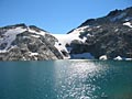
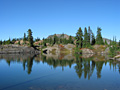
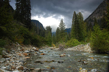 McMillan Creek 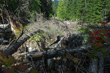 Another example of an obstacle that caused me to have to cross the creek. 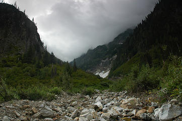 This is the first inlet into McMillan Creek on the south side. Actually looking at the map closer its the second. This is the creek on the east side of Elephant Butte. This was so much easier to walk up than the brush. 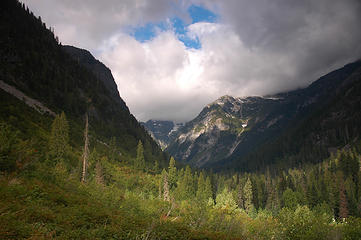 This is as much of a view that I got after scrambling partway up the base of Elephant Butte till I could see over the brush up the creek. 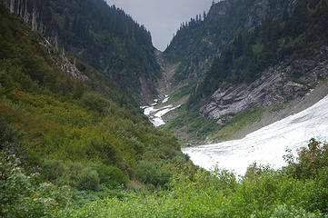 The bowl between Elephant Butte (on the right) and an un-named ridge. 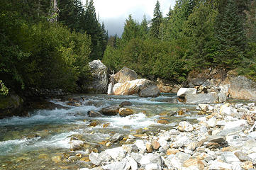 View of McMillan Creek as I criss crossed my way back down to Big Beaver Creek. 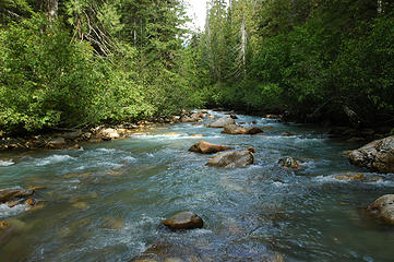 This is the view of Big Beaver where I crossed to gain access to McMillan Creek. 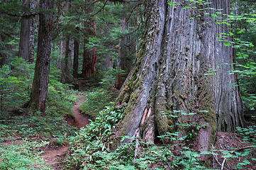 A series of photos of Big Beaver Trail, a gorgeous hike with the largest stand of old growth cedar. 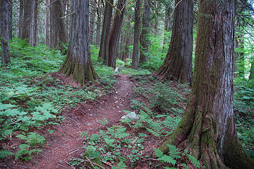 Around and through 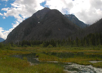 Big Beaver Creek
|
| Back to top |
|
|
Malachai Constant
Member
Joined: 13 Jan 2002
Posts: 16098 | TRs | Pics
Location: Back Again Like A Bad Penny |
Sorry if I flew off the handle but I was just trying to prevent a future "news story". Especially if some heirs decided to blame this website or the folks here. 
"You do not laugh when you look at the mountains, or when you look at the sea." Lafcadio Hearn
"You do not laugh when you look at the mountains, or when you look at the sea." Lafcadio Hearn
|
| Back to top |
|
|
cascadetraverser
Member

Joined: 16 Sep 2007
Posts: 1407 | TRs | Pics
|
If you really want to traverse the entire picket range consider going north to south starting at Beaver Pass up to Challenger arm via a forest bushwack following challenger arm until it reaches the Challenger Glacier which you follow until reaching the 3rd notch from the west (I believe) of Challenger and then you cross over this onto the small glacier which leads out to a scramble down to the basin west of Crooked thumb and Phantom. From there you head up to Pickell pass and then make your way (a very tough long day) to picket pass dropping down to a tarn below and then crossing below the southern pickets (and the bowling alley as its known for falling glacier debris, no problems for us) up to Azure col and out the Elephant Butte HR. Plan on at least 9 to 10 days and you obviously need great routefinding skills and crevasse axe rescue/glacier travel experience. I did it last year and it was great.
You can also start at Hannegan, go up Easy ridge and then up to Perfect Pass over the Challenger Glacier the other way cross Luna Cirque to Luna Lake up to Luna Col and out axes creek (aka access) to big beaver. This way does not really traverse the Southern pickets but you get great views of them. It is a 6 or more day trip.
|
| Back to top |
|
|
Mark Griffith
(Embrace yourself)
Joined: 14 Mar 2005
Posts: 853 | TRs | Pics
Location: Issaquah |
Thanks for the helpful suggestions, we may not end up doing a traverse the first time out, and Perfect Pass has always sounded so nice, I guess the name itself conjures up wonder. Do you have pics from your trip?
|
| Back to top |
|
|
cascadetraverser
Member
Joined: 16 Sep 2007
Posts: 1407 | TRs | Pics
|
Yes; I have to confess I haven`t joined this website sooner because I am such a computer loser. I do have a link and I will find it and get back to you. Perfect pass is nice (and we were there in a white out this summer there) but getting there is some work. Perfect impasse stands in the way and that is some work. We went down and around and up and getting back to the cirque below Perfect pass involved class 3 scrambling and hanging vertically on slide alder. Good luck!
|
| Back to top |
|
|
|
|


