| Previous :: Next Topic |
| Author |
Message |
Matt
Tea, Earl Grey, Hot


Joined: 30 Jan 2007
Posts: 4307 | TRs | Pics
Location: Shoreline |
|
Matt
Tea, Earl Grey, Hot
|
 Thu Sep 06, 2007 12:06 am |
|
|
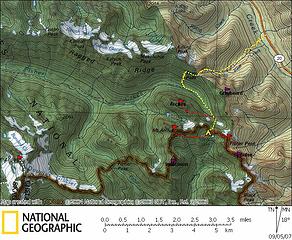
Dates: August 31 September 2, 2007
Party: Matt, mtnmike, Billie B, Dicey, Yana
Day 1: Hike to Silent Lakes via Easy Pass
Day 2: Ascend Fisher 8040 and Arrivia 8215
Day 3: Hike down to Fisher Basin, ascend Arches (aka Little Johannesburg) 7945, hike out via Easy Pass
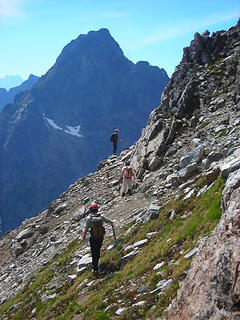
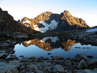
 Silent Lakes Approach & Vicinity 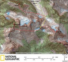 Silent Lakes Summits 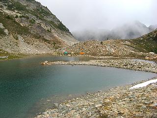 Evening & Cloudy 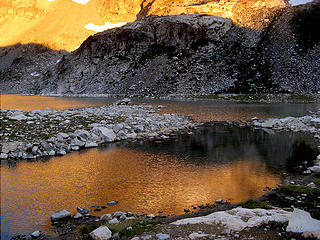 Dawn & Golden 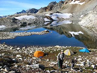 Morning & Clear 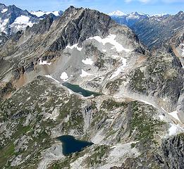 Looking from Fisher to Arriva 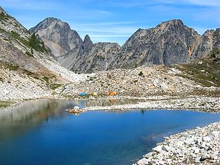 Midday & Sunny 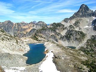 Looking from Arriva to Fisher 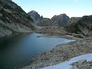 Shadowed 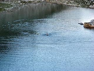 Swimming 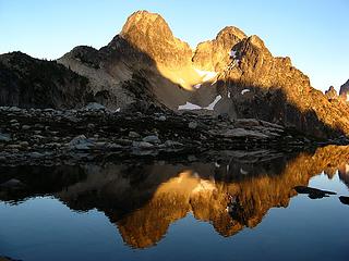 Reflective 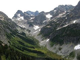 Fisher Creek Basin, with Fisher, Black, & Arriva. Silent Lakes is in the col between Fisher & Arriva. 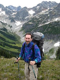 Matt at Easy Pass 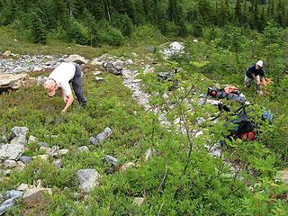 Blueberry Harvest 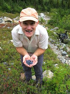 Blueberry Bounty 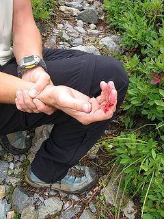 Blueberry Tragedy 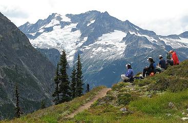 Easy Pass & Logan 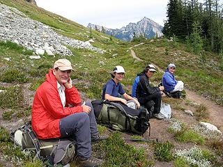 Easy Pass with Golden Horn & Hardy 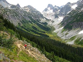 Descending toward Fisher Creek 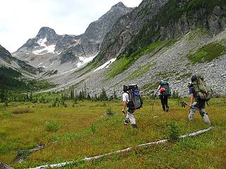 Hiking up the meadows 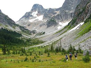 Hiking up the meadows 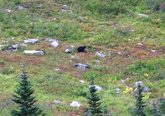 Berry-grazing Bear 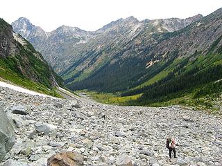 Up the endless talus fields 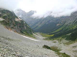 Hikers rising higher, clouds dropping lower 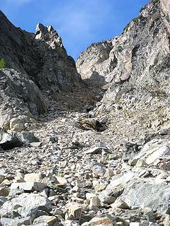 Looking up the gully 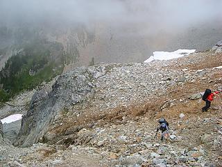 Top of the gully 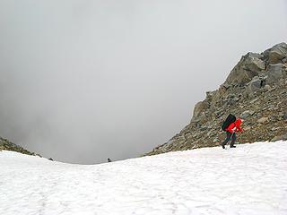 Snow at top of the gully Upper Silent Lake 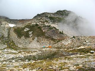 Smaller Pool & Outlet 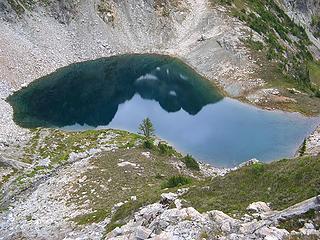 Lower Silent Lake 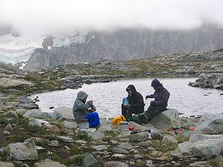 Dinner as the clouds close down on us 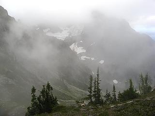 Clouds shrouding Black Peak 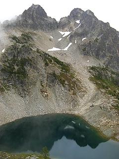 Mostly clear 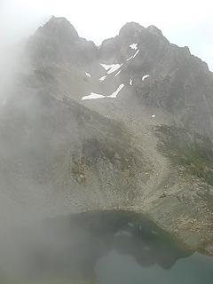 Partly cloudy 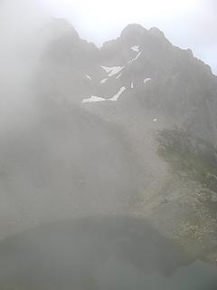 Mostly cloudy  Cloudy
As beacons mountains burned at evening. J.R.R. Tolkien
As beacons mountains burned at evening. J.R.R. Tolkien
|
| Back to top |
  
|
|
Dayhike Mike
Bad MFKer
Joined: 02 Mar 2003
Posts: 10958 | TRs | Pics
Location: Going to Tukwila |
Sweeeeet! Nice work guys. I'm looking forward to shots of Lake 5972. 
"There is only one basic human right, the right to do as you damn well please. And with it comes the only basic human duty, the duty to take the consequences." -P.J. O'Rourke
"Ignorance is natural. Stupidity takes commitment." -Solomon Short
"There is only one basic human right, the right to do as you damn well please. And with it comes the only basic human duty, the duty to take the consequences." -P.J. O'Rourke
"Ignorance is natural. Stupidity takes commitment." -Solomon Short
|
| Back to top |
|
|
peltoms
Member

Joined: 13 Jul 2006
Posts: 1760 | TRs | Pics
Location: Worcester MA |
|
peltoms
Member
|
Thu Sep 06, 2007 4:31 am |
|
|
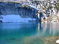
Silent Lake what a gorgeous location for a camp. And though I have been to Easy Pass several times, I was too busy looking up to the peaks and glaciers to see how gorgeous Upper Fisher Basin is.
|
| Back to top |
|
|
Backpacker Joe
Blind Hiker

Joined: 16 Dec 2001
Posts: 23956 | TRs | Pics
Location: Cle Elum |
Beautiful pics Matt. Cant wait to get in there. I think Ill take the non easy pass route that was suggested in an earlier trip.
"If destruction be our lot we must ourselves be its author and finisher. As a nation of freemen we must live through all time or die by suicide."
Abraham Lincoln
"If destruction be our lot we must ourselves be its author and finisher. As a nation of freemen we must live through all time or die by suicide."
Abraham Lincoln
|
| Back to top |
|
|
Yana
Hater

Joined: 04 Jun 2004
Posts: 4212 | TRs | Pics
Location: Out Hating |
|
Yana
Hater
|
Thu Sep 06, 2007 8:25 pm |
|
|
Excellent photos, Matt. Can't wait to see the rest of them. That gully looks just as unpleasant as I remember it!
Thanks for organizing a wonderful outing.
Here are a couple of pics:
 On the way to Arriva 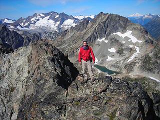 Matt on Fisher 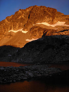 Morning light at camp 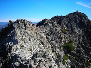 Fisher summit 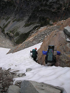 Moat fun 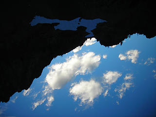 An odd perspective
PLAY SAFE! SKI ONLY IN CLOCKWISE DIRECTION! LET'S ALL HAVE FUN TOGETHER!
PLAY SAFE! SKI ONLY IN CLOCKWISE DIRECTION! LET'S ALL HAVE FUN TOGETHER!
|
| Back to top |
|
|
Quark
Niece of Alvy Moore

Joined: 15 May 2003
Posts: 14152 | TRs | Pics
|
|
Quark
Niece of Alvy Moore
|
Thu Sep 06, 2007 8:42 pm |
|
|
Even with a blue berry squished in between his teeth, MtnMike is the most photogenic person ever. Well, besides my grandpa.
Looks like a wonderful trip; fantastic photos Matt. You have quite the eye for it.
I like your beard, by the way.
"...Other than that, the post was more or less accurate."
Bernardo, NW Hikers' Bureau Chief of Reporting
"...Other than that, the post was more or less accurate."
Bernardo, NW Hikers' Bureau Chief of Reporting
|
| Back to top |
|
|
Tom_Sjolseth
Born Yesterday

Joined: 30 May 2007
Posts: 2652 | TRs | Pics
Location: Right here. |
Sweet trip, guys and gals!
|
| Back to top |
|
|
pimaCanyon
Member

Joined: 13 Jul 2007
Posts: 1304 | TRs | Pics
Location: at the bottom of the map |
what a great TR! I especially liked the story about your hiking Easy Pass when you were a kid and here it is how many years later, and you're back. And beyond to Silent Lakes and more...
Silent Lakes have been on my list for years, but now that my main hiking partner is my pooch Zia, I'm not sure when I'll get there. (No dogs in NCNP). Your pix show it to be even more beautiful than I expected. That's the good news. The bad news is I should have gone when I had the chance... 
It's never too late to have a happy childhood
It's never too late to have a happy childhood
|
| Back to top |
|
|
Starjumper7
Human
Joined: 10 Jan 2006
Posts: 1426 | TRs | Pics
Location: Southern Ecuador wilderness |
Nice pictures. We did a similar trip to Silent lakes a week earlier and went up the same gulley to Silent lakes that you did. You know, there's a 'trail' up to there if you go just a little farther up the talus past the gulley. We also ended up abandoning the gulley and going up on the rock to the left, like you mentioned. I'm impressed, you old farts get to go hiking with all those beautiful young ladies. I should try that some day.
|
| Back to top |
|
|
Captain Trips
Member

Joined: 06 Mar 2002
Posts: 437 | TRs | Pics
|
I certainly was impressed with Arches while camping at the fisher creek campground, disappointed that my map merely had an elevation for the name of the peak. What great climbing routes one could establish if they were young and aspiring dirtbag climbers.
Starjumper commented on the attractive group of scramblers in this group, hopefully not a reflection on Captain Trips and Dane, two model outdoorsmen who accompanied Starjumper on his trip.
|
| Back to top |
|
|
dicey
custom title

Joined: 11 May 2004
Posts: 2870 | TRs | Pics
Location: giving cornices a wider berth |
|
dicey
custom title
|
Thu Sep 06, 2007 11:16 pm |
|
|
| Yana wrote: | | A memorable quote from the trip:
dicey, on the joy of descending steep, loose scree:
"Just think of it as snow, except harder on your pants." |
I don't remember saying that - BIG SURPRISE!
(what is my name again, btw?  )
Anyway,
Here are the pics I took that I liked : )
Anyway,
Here are the pics I took that I liked :
 black reflection 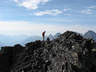 matt arriva 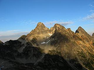 fisher 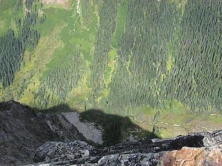 fisher creek from arches
|
| Back to top |
|
|
Matt
Tea, Earl Grey, Hot
Joined: 30 Jan 2007
Posts: 4307 | TRs | Pics
Location: Shoreline |
|
Matt
Tea, Earl Grey, Hot
|
Fri Sep 07, 2007 1:12 am |
|
|
Day 2 Morning, Fisher
At bedtime, the sky was overcast except for one star. 3am, still mostly overcast but the moon was peeking through. 6am, I noticed the sides of the tent were lighter, but was too lazy to open the door. 6:30am, Yana yelled for us to look outside at the sunrise. I opened the door, but no light on the peaks. Yana yelled to look at the other side. Whoa, the east end of Arriva across the lake was lit up bright yellow. I hurried into my clothes and got a few photos before the color faded. It was still cold, so we went back to bed. 7:45am, the sun climbed over the crest and began melting the ice off the tents, so we got up. 9am, we finally departed camp heading for Fisher.
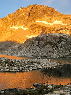 Dawn Reflection 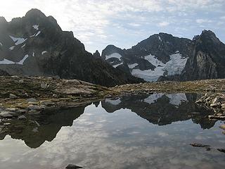 Breakfast Reflection 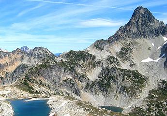 The ridge from Upper Silent Lake to Fisher Departing for Fisher 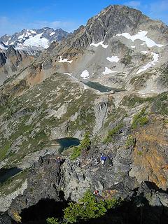 Scrambling over bumps on the lower ridge 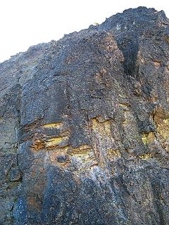 Crux is on the left (easier than it looks) 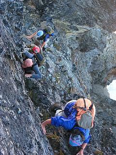 Climbers coming up the crux (okay, maybe sort of hard) 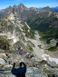 Nearing the summit ridge (Arches, Ragged Ridge, Kitling, & Fisher Creek in background) 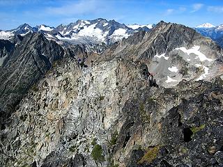 Traversing the summit crest. 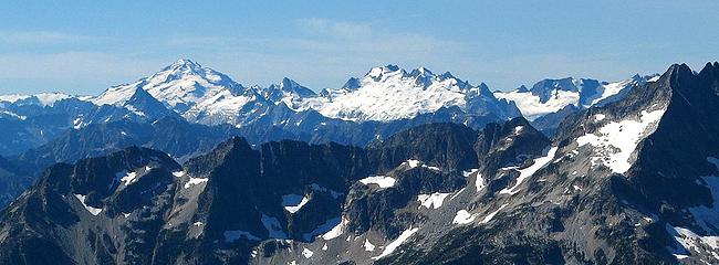 Glacier, Sinister, & Dome 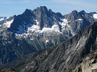 Goode & Stormking 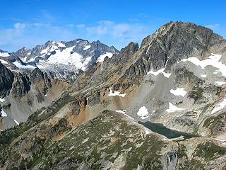 Logan & Arriva 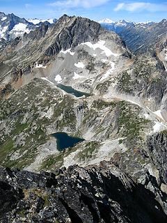 Silent Lakes & Arriva 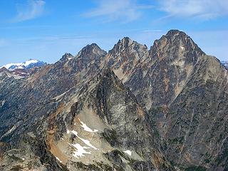 Arches & Ragged Ridge (Cosho, Kimtah, Katsuk, Mesachie) 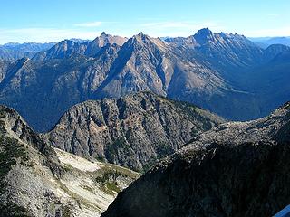 Golden Horn, Hardy, & Tower 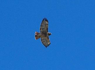 Hawk above the summit 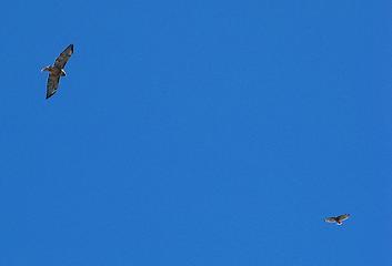 Hawks above the summit 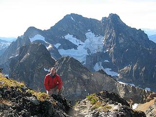 Matt & Black Peak 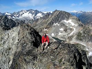 Matt on Fisher Summit Ridge 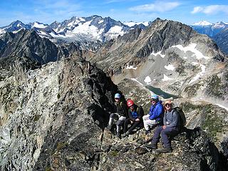 Yana, Dicey, Billie, & Mike on Fisher Summit Ridge 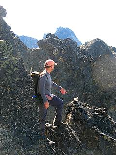 Mike on the ridge 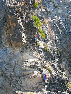 Descending the ridge 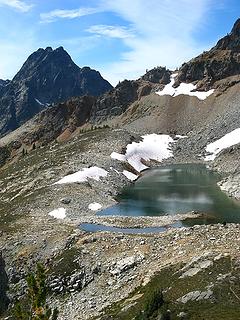 Return to Upper Silent Lake
As beacons mountains burned at evening. J.R.R. Tolkien
As beacons mountains burned at evening. J.R.R. Tolkien
|
| Back to top |
|
|
Starjumper7
Human
Joined: 10 Jan 2006
Posts: 1426 | TRs | Pics
Location: Southern Ecuador wilderness |
| Captain Trips wrote: | | Starjumper commented on the attractive group of scramblers in this group, hopefully not a reflection on Captain Trips and Dane, two model outdoorsmen who accompanied Starjumper on his trip. |
No reflection, you guys are terribly cute, but just not attractive in the same way as nice healthy females. However, being surrounded by said females, it might be hard to get to sleep.
|
| Back to top |
|
|
Matt
Tea, Earl Grey, Hot
Joined: 30 Jan 2007
Posts: 4307 | TRs | Pics
Location: Shoreline |
|
Matt
Tea, Earl Grey, Hot
|
Sun Sep 09, 2007 1:41 am |
|
|
Day 2 Afternoon, Arriva
It felt very odd to just pass through our own camp in the middle of the day en route from one peak to another. We stopped only briefly to filter water, so that wed have time for Arriva. Under the warm midday sun, the lake looked so tempting for a swim, but would have to wait till later.
Looking back to Upper Silent Lake & Fisher as we depart for Arriva 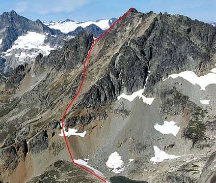 Route to Arriva 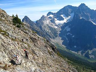 Traversing across Arriva (Repulse & Black Peaks behind) 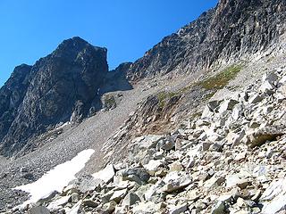 Notch on the final ridge 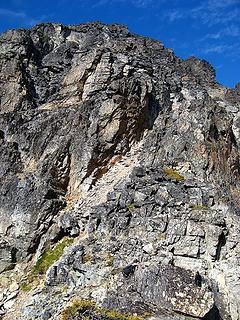 Gully upward above the 7760 notch 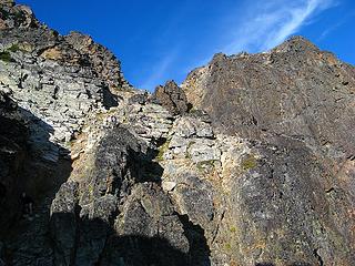 Last gully upward to crest between east summit (right) and main summit (left). (Note Yana in shadow) 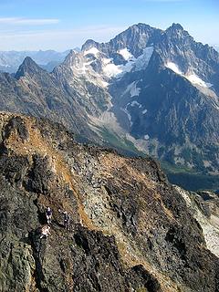 Descending last point before the summit 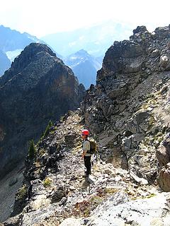 Ledge around the summit 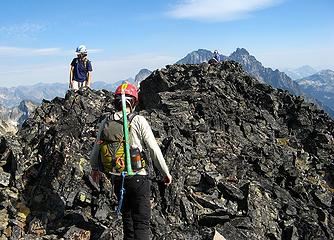 Arriving at the summit 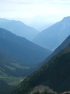 Smoky View southward 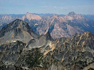 Looking north to Graybeard, Little Tack, Golden Horn, Hardy, & Tower 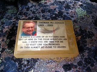 Memorial plaque 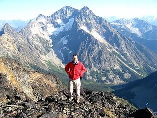 Matt at the summit 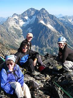 Billie, Dicey, Mike, & Yana on the summit 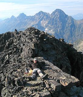 Yana relaxing near the summit 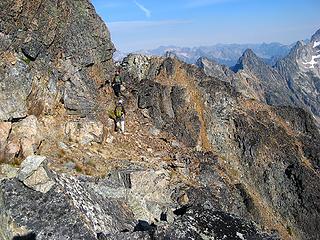 Returning on the circum-summit ledge. 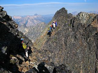 Over the point from the summit ledge to the notch by the east summit. Upper Silent Lake falling into shadow 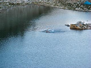 Swimming out from the peninsula 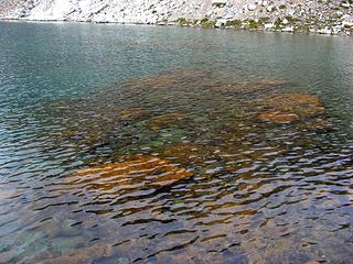 Red rocks in the water  Black Peak sunset Fisher sunset 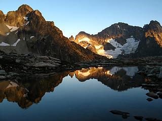 Shadow & Light
As beacons mountains burned at evening. J.R.R. Tolkien
As beacons mountains burned at evening. J.R.R. Tolkien
|
| Back to top |
|
|
Backpacker Joe
Blind Hiker
Joined: 16 Dec 2001
Posts: 23956 | TRs | Pics
Location: Cle Elum |
Way to round out the report Matt. Thanks.
"If destruction be our lot we must ourselves be its author and finisher. As a nation of freemen we must live through all time or die by suicide."
Abraham Lincoln
"If destruction be our lot we must ourselves be its author and finisher. As a nation of freemen we must live through all time or die by suicide."
Abraham Lincoln
|
| Back to top |
|
|
|
|
You cannot post new topics in this forum
You cannot reply to topics in this forum
You cannot edit your posts in this forum
You cannot delete your posts in this forum
You cannot vote in polls in this forum
|
Disclosure: As an Amazon Associate NWHikers.net earns from qualifying purchases when you use our link(s). |


