| Previous :: Next Topic |
| Author |
Message |
cartman
Member


Joined: 20 Feb 2007
Posts: 2800 | TRs | Pics
Location: Fremont |
|
cartman
Member
|
 Mon Oct 01, 2007 4:51 pm |
|
|
| Yana wrote: | | dicey wrote: | Still haven't summited Snowgrass, but we got that pesky Ladies Peak knocked out, eh?
 |
Yeah. It's a shame there were no ladies around to enjoy it.
On another random note, when I read the sentence above, my brain keeps trying to replace "out" with "up" for some reason.  |
No comment.
|
| Back to top |
  
|
|
Mesahchie Mark
A Lerxst

Joined: 10 May 2005
Posts: 700 | TRs | Pics
Location: In Wonderland |
Now I can't get the Beastie Boys song out of my head:
"Hey, Ladies!"
Thinking back on it, it's kinda funny because TDD was asking at one point where Ladies Peak was...
|
| Back to top |
|
|
Yet
Member

Joined: 23 Apr 2005
Posts: 2634 | TRs | Pics
Location: Happily Ever After |
|
Yet
Member
|
Mon Oct 01, 2007 5:14 pm |
|
|
| Mesahchie Mark wrote: | | Thinking back on it, it's kinda funny because TDD was asking at one point where Ladies Peak was... |
Now that you are getting a GPS, you should be able to find it next time with no problem. And know that you are on it.
|
| Back to top |
|
|
Sabahsboy
Member

Joined: 18 Jul 2006
Posts: 2484 | TRs | Pics
Location: SW Sno County |
|
Sabahsboy
Member
|
Mon Oct 01, 2007 5:16 pm Snowgass
|
|
|
You folks have me pondering what I ascended way, way back in 1970's. I did the lazy way and spent a bunch of days wandering around. The view from summit to Glacier sticks in my mind. I have an enlargment and will take a look and see if I can figure out if I was really at Snowgrass. What I recall was a rocky summit with lots of room to lay down in the sun and enjoy a beautiful afternoon. Coming down, late sun gave the snowy slopes beautiful color, still etched in my memory.
|
| Back to top |
|
|
Mesahchie Mark
A Lerxst
Joined: 10 May 2005
Posts: 700 | TRs | Pics
Location: In Wonderland |
| Yet wrote: | | Mesahchie Mark wrote: | | Thinking back on it, it's kinda funny because TDD was asking at one point where Ladies Peak was... |
Now that you are getting a GPS, you should be able to find it next time with no problem. And know that you are on it. |
Ack! You're blowing my lo-tek cover!
Maybe I won't get one now...:P
|
| Back to top |
|
|
Sabahsboy
Member
Joined: 18 Jul 2006
Posts: 2484 | TRs | Pics
Location: SW Sno County |
|
Sabahsboy
Member
|
Mon Oct 01, 2007 6:29 pm Snowgrass
|
|
|
Photo of Snowgrass does look very familiar, sans snow fields. I think I was there at end of June. Maybe 1977 or '78. Later that summer did the loop over Chiwaukums and Icicle Ridge.
That Ladies Peak looks might rugged! Scary!
|
| Back to top |
|
|
yukon222
Member

Joined: 12 Mar 2007
Posts: 1893 | TRs | Pics
|
|
yukon222
Member
|
Mon Oct 01, 2007 6:45 pm |
|
|
| Pütz-in-Boots wrote: | | Anyway, here is a pic in good weather of the peak you did:
|
Yep, that is definitely it. Thanks for the picture! We went up the gully between the two peaks and then climbed up the taller one to the right. It was so cloudy/foggy that we couldn't really see much of anything farther to the right. Here's a quick summit video from the right side peak.
|
| Back to top |
|
|
Mark Griffith
(Embrace yourself)
Joined: 14 Mar 2005
Posts: 853 | TRs | Pics
Location: Issaquah |
|
| Back to top |
|
|
twodogdad
Member
Joined: 21 Nov 2006
Posts: 846 | TRs | Pics
Location: seattle |
Yep, that is definitely it [...] We went up the gully between the two peaks and then climbed up the taller one to the right.
Steve: Clarification, please (I'm going back, sooner or later, to finish the job):
There was a gully in the middle of which I had to lift the dogs (so I remember it well): it seemed narrower than this one. It started more or less right after we contoured the cliffs around 7000 and eventually led to the broad ridge at 7300-7400, the end of which I could not see (that's where I turned back). Is this a *second* gully you climbed after you reached the end of the broad ridge? Or am I confused by the angle of the pic? thx, tdd
|
| Back to top |
|
|
yukon222
Member
Joined: 12 Mar 2007
Posts: 1893 | TRs | Pics
|
|
yukon222
Member
|
Mon Oct 01, 2007 10:54 pm |
|
|
| twodogdad wrote: | | Yep, that is definitely it [...] We went up the gully between the two peaks and then climbed up the taller one to the right.
Steve: Clarification, please (I'm going back, sooner or later, to finish the job):
There was a gully in the middle of which I had to lift the dogs (so I remember it well): it seemed narrower than this one. It started more or less right after we contoured the cliffs around 7000 and eventually led to the broad ridge at 7300-7400, the end of which I could not see (that's where I turned back). Is this a *second* gully you climbed after you reached the end of the broad ridge? Or am I confused by the angle of the pic? thx, tdd |
TDD - Yes, 2nd gully. This is the final summit gully 45 minutes past the narrow chute which you carried the dogs up and I included the picture of Yana ascending. That gully was just past the pocket of trees when we separated from you. Around the corner was that narrow gully which puts you up on the broad ridge. After heading north on that to the end, rocks force a descent back down to the right before climbing back up to the final summit gully in PIB's shot, the summit video and a few of my pics.
Amazing that you lifted the dogs up that 1st slot gully!. It was steep and slick but better than the other possible points nearby.
|
| Back to top |
|
|
Matt
Tea, Earl Grey, Hot

Joined: 30 Jan 2007
Posts: 4307 | TRs | Pics
Location: Shoreline |
|
Matt
Tea, Earl Grey, Hot
|
Mon Oct 01, 2007 11:55 pm |
|
|
This so much more entertaining than if you had just climbed Snowgrass!
Not only did you climb a different peak, but you also climbed it by the more difficult route, though also most direct.
Which makes it even more of an accomplishment in those conditions.
Heres how the area looked when I was there 9/23 9/24/06
Snowgrass:
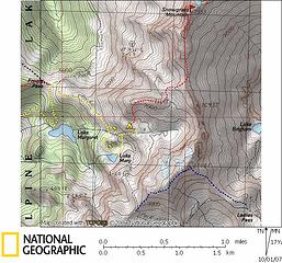 Snowgrass & Ladies Map 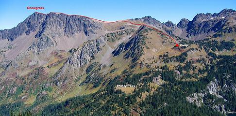 1 label Snowgrass Route, viewed from Frosty Mtn. Ladies peak at right. 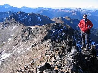 Snowgrass Summit. Ladies Peak is at rear left, 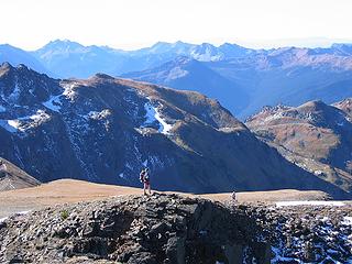 PiB coming up the route 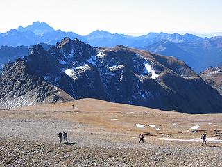 Hordes on grassy lump part of Snowgrass, with Ladies summit behind 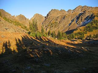 Ladies Peak from camp in Snowgrass/Ladies Basin. Which gully did you go up? 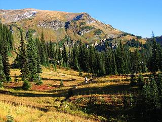 Easier terrain up Ladies Peak, either from the left or right. From the trail at right, Beckey blithely declares that its an easy hike. 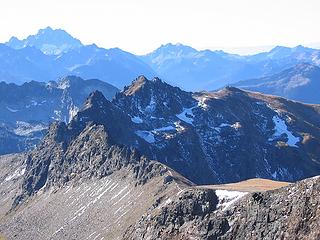 1 label Ladies Peak summit area, viewed from Snowgrass 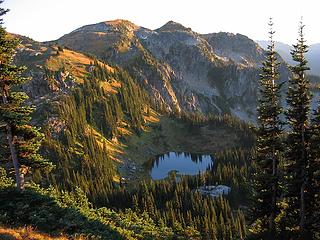 Mary Lake in evening light 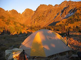 Camp at sunset in Snowgrass/Ladies Basin. 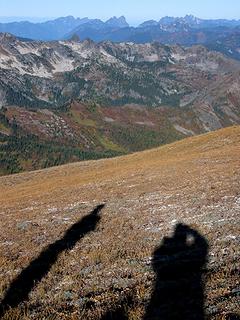 View from Snowgrass ridge 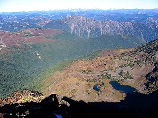 Lower Grace Lakes 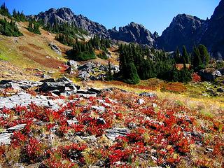 Snowgrass/Ladies Basin. 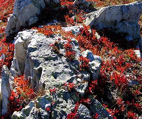 Fall color on Frosty Mtn  Frosty Mtn
As beacons mountains burned at evening. J.R.R. Tolkien
As beacons mountains burned at evening. J.R.R. Tolkien
|
| Back to top |
|
|
ActionBetty
Im a dirty hippie!

Joined: 06 Jul 2003
Posts: 4807 | TRs | Pics
Location: kennewick, wa |
|
ActionBetty
Im a dirty hippie!
|
Tue Oct 02, 2007 5:21 am |
|
|
This report made my feet hurt..oh the mileage  Great photos and loving all this new snow
"If you're not living good, you gotta travel wide"...Bob Marley
"If you're not living good, you gotta travel wide"...Bob Marley
|
| Back to top |
|
|
dicey
custom title

Joined: 11 May 2004
Posts: 2870 | TRs | Pics
Location: giving cornices a wider berth |
|
dicey
custom title
|
Tue Oct 02, 2007 8:30 am |
|
|
Thanks for the pictures Matt. The link on your site to pictures from your Snowgrass/Frosty trip from last fall isn't working, so I appreciate being able to see them.

|
| Back to top |
|
|
Mesahchie Mark
A Lerxst
Joined: 10 May 2005
Posts: 700 | TRs | Pics
Location: In Wonderland |
Great pics Matt! It's nice to see what Ladies Peak looks like, having climbed it...
Your "easy terrain" and "summit" pics completely correspond with my memory from the ascent. We actually climbed the ridge from the right of "easy terrain", traveling NE under the cliffs until we could find a gully to work from that side.
The features of Ladies' summit ridge match our experience.
Funny how things appear easier when you can see them!
-MM
|
| Back to top |
|
|
|
|


