| Previous :: Next Topic |
| Author |
Message |
GeoTom
Member


Joined: 19 May 2005
Posts: 3215 | TRs | Pics
Location: Earth |
|
GeoTom
Member
|
 Sat Sep 29, 2007 9:18 pm |
|
|
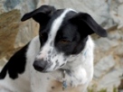
Jasper and I headed to the Lake Wenatchee/White River area today to see how far we could get up Mt. David. We stopped at 7,420 feet. Luckily for us that was the summit  Details:
I woke up at 5:30
Details:
I woke up at 5:30  and grabbed the dog. Left the house by 6:00. He fell back asleep in the car on the drive over (lazy dog!)
Arrived at the trailhead at~8:20. We started moving quickly as it was cold at the trailhead. Normally I slow down after the first few minutes, but I felt strong today (maybe it was the pizza last night and grabbed the dog. Left the house by 6:00. He fell back asleep in the car on the drive over (lazy dog!)
Arrived at the trailhead at~8:20. We started moving quickly as it was cold at the trailhead. Normally I slow down after the first few minutes, but I felt strong today (maybe it was the pizza last night  ) and managed to summit in ~3.5 hours. No speed record, but good for me, especially since the trail gains 5,200 (maybe more with the ups and downs) in 7 miles.
We saw a light dusting of snow at ~5,600' that was more noticeable on the north and east aspects. Near the summit it was slightly over an inch deep in places.
It warmed up a bit on the descent and much of the dusting had melted. Luckily we only had a few minutes of snow flurries all day. Unfortunately, it was the few minutes we were at the summit. No views of NWHikers sweetheart, Glacier Peak ) and managed to summit in ~3.5 hours. No speed record, but good for me, especially since the trail gains 5,200 (maybe more with the ups and downs) in 7 miles.
We saw a light dusting of snow at ~5,600' that was more noticeable on the north and east aspects. Near the summit it was slightly over an inch deep in places.
It warmed up a bit on the descent and much of the dusting had melted. Luckily we only had a few minutes of snow flurries all day. Unfortunately, it was the few minutes we were at the summit. No views of NWHikers sweetheart, Glacier Peak  but I bet she's still there.
One of my motivations for doing this hike was to get a look at the stone privy near the summit. Somehow I forgot to actually research where it was last night but I bet she's still there.
One of my motivations for doing this hike was to get a look at the stone privy near the summit. Somehow I forgot to actually research where it was last night  I thought I recalled JimK saying it was ~200 feet down the north slope from the summit. I looked for a few minutes, but with the snow covered ground and the winds picking up, I decided to abandon the search. I thought I recalled JimK saying it was ~200 feet down the north slope from the summit. I looked for a few minutes, but with the snow covered ground and the winds picking up, I decided to abandon the search.  We encountered a few other hardy souls today, but no hunters on the trail
  Descent took ~3 hours. That last flattish mile seems to take forever.
Some pictures:
Descent took ~3 hours. That last flattish mile seems to take forever.
Some pictures:
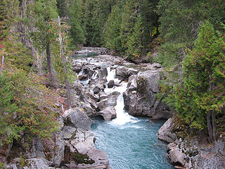 White River from the bridge at the start 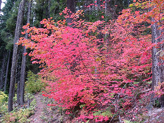 Yep, it's fall 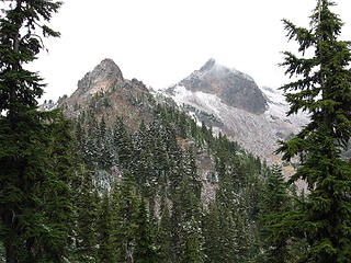 First glimpse of the goal 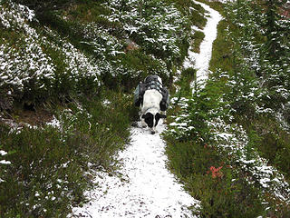 Yummy snow 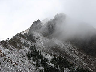 Clouds and ridge 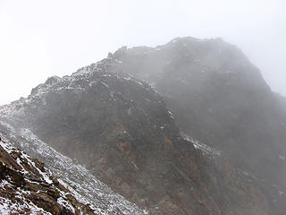 Foggy summit 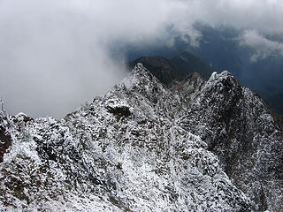 Snowy ridge 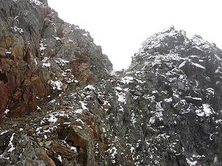 Almost there 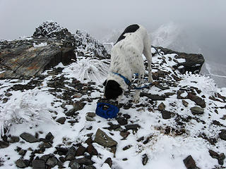 Lunch 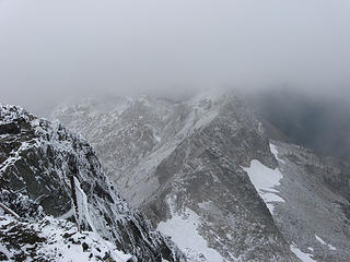 View down the north side 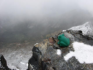 Soapy the frog on Mt. David 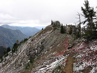 Less snow on the descent 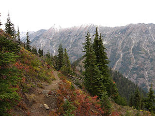 Still fall 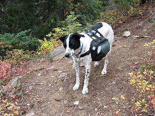 Happy trail dog (unleashed!) 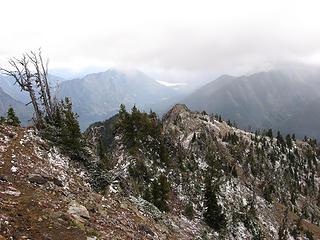 On the descent
|
| Back to top |
  
|
|
silly_traveler
~ roaming ~

Joined: 04 Jun 2006
Posts: 1525 | TRs | Pics
Location: Bellevue |
♫ You have brains in your head. You have feet in your shoes. You can steer yourself any direction you choose. And you're the one who will decide where you'll go. Oh the places you'll go. - Dr. Seuss
|
| Back to top |
|
|
Backpacker Joe
Blind Hiker

Joined: 16 Dec 2001
Posts: 23956 | TRs | Pics
Location: Cle Elum |
Nice pics GT. 
"If destruction be our lot we must ourselves be its author and finisher. As a nation of freemen we must live through all time or die by suicide."
Abraham Lincoln
"If destruction be our lot we must ourselves be its author and finisher. As a nation of freemen we must live through all time or die by suicide."
Abraham Lincoln
|
| Back to top |
|
|
the Zachster
Member

Joined: 17 Jan 2007
Posts: 4776 | TRs | Pics
Location: dog training |
3.5 hours is quite respectable for that trail...good for you! And going leashless, how daring. Zach is SOOOO jealous...
"May I always be the kind of person my dog thinks I am"
"May I always be the kind of person my dog thinks I am"
|
| Back to top |
|
|
GeoTom
Member
Joined: 19 May 2005
Posts: 3215 | TRs | Pics
Location: Earth |
|
GeoTom
Member
|
Sat Sep 29, 2007 9:35 pm |
|
|
| silly_traveler wrote: | I wanna see that stone privy too Maybe you wanna go up again next year  |
Sure, but let's do it in late August or early September, before the snows!
|
| Back to top |
|
|
Mtn Dog
Technohiker

Joined: 01 Aug 2004
Posts: 3336 | TRs | Pics
Location: Bellevue, WA |
|
Mtn Dog
Technohiker
|
Sun Sep 30, 2007 12:18 am |
|
|
GeoTom: The summit is sort of shaped like a two-humped camel. The true summit is the east hump that you arrive at after ascending the rock ledge. If you traverse over/around the west hump, which also has the benchmark and a 2nd reference mark near the top, the rock outhouse is on the NW edge of the west hump. It's maybe 30-40' from where the trails ends and its door faces west so you can relieve yourself while taking in the view of Whittier Peak and Mt Jonathan.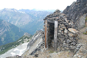 Best place to pee above 7,000'!
Footprints on the sands of time will never be made sitting down.
Footprints on the sands of time will never be made sitting down.
|
| Back to top |
|
|
Yana
Hater

Joined: 04 Jun 2004
Posts: 4212 | TRs | Pics
Location: Out Hating |
|
Yana
Hater
|
Sun Sep 30, 2007 9:17 am |
|
|
Nice, GeoTom! I've been meaning to do Mt. David for years, but somehow I always end up doing something else.  White River sure is pretty.
PLAY SAFE! SKI ONLY IN CLOCKWISE DIRECTION! LET'S ALL HAVE FUN TOGETHER!
PLAY SAFE! SKI ONLY IN CLOCKWISE DIRECTION! LET'S ALL HAVE FUN TOGETHER!
|
| Back to top |
|
|
Magellan
Brutally Handsome

Joined: 26 Jul 2006
Posts: 13116 | TRs | Pics
Location: Inexorable descent |
|
Magellan
Brutally Handsome
|
Sun Sep 30, 2007 11:04 am |
|
|
Sweet! This may get done before the year is out.
|
| Back to top |
|
|
twodogdad
Member

Joined: 21 Nov 2006
Posts: 846 | TRs | Pics
Location: seattle |
Greetings, unleashed one and leash carrier: Did you find a blank spot to sign in the "register"?--that and finding the outhouse are the secret challenges of David  Last Monday, we had to add our names to the USGS topo someone stuck in evidently years ago... If someone plans a Mt David hike this year please bring a new notebook, for posterity's sake. Should the old one (ones, I should say), be handed over to the UW library? tdd Last Monday, we had to add our names to the USGS topo someone stuck in evidently years ago... If someone plans a Mt David hike this year please bring a new notebook, for posterity's sake. Should the old one (ones, I should say), be handed over to the UW library? tdd
|
| Back to top |
|
|
summitseeker
Member
Joined: 31 Mar 2006
Posts: 138 | TRs | Pics
Location: Seattle |
Cool! We were the party of two behind you. Had a great trip also. Beautiful spot.
"Find out who you are and then do it on purpose."
www.summitroutes.com : Guidebook to the 100 highest peaks in Washington
"Find out who you are and then do it on purpose."
www.summitroutes.com : Guidebook to the 100 highest peaks in Washington
|
| Back to top |
|
|
GeoTom
Member
Joined: 19 May 2005
Posts: 3215 | TRs | Pics
Location: Earth |
|
GeoTom
Member
|
Sun Sep 30, 2007 11:46 am |
|
|
tdd-
I didn't even think of looking for the register on top I found a safe spot to leash Jasper, gave him his lunch and took a few photos. Maybe next time
summitseekr-
So you were the two I encountered just below the summit? Nice to have "met" you.
Mtn Dog-
Thanks for the info on the loo. Maybe next August I'll have to use it...
|
| Back to top |
|
|
summitseeker
Member
Joined: 31 Mar 2006
Posts: 138 | TRs | Pics
Location: Seattle |
| GeoTom wrote: | | summitseekr-
So you were the two I encountered just below the summit? Nice to have "met" you. |
Yes, that was me and Jane. You flew past us on the way up also. Good to meet you too, and share that great spot. There was another group of 3 that we met coming down from the summit -- gather you met them as well. My TR is here.
"Find out who you are and then do it on purpose."
www.summitroutes.com : Guidebook to the 100 highest peaks in Washington
"Find out who you are and then do it on purpose."
www.summitroutes.com : Guidebook to the 100 highest peaks in Washington
|
| Back to top |
|
|
tomastaylor
Member
Joined: 11 May 2007
Posts: 90 | TRs | Pics
|
Here's a picture of the trail to the outhouse from the top:
I climbed down from the flat mountain top and scrambled around the perimeter of the summit looking for the outhouse. It didn't take long to see that it would be far too dangerous to build an outhouse there so I stood on the summit looking for a more suitable location. That's when I saw the trail to the outhouse. When heading down the trail from the top, stay right on the ridge.
|
| Back to top |
|
|
deconinc
Member

Joined: 22 Jun 2005
Posts: 34 | TRs | Pics
|
|
deconinc
Member
|
Mon Oct 01, 2007 7:11 am |
|
|
Sweet. We were the group of three. Looks like everyone is here now. Our trip report (mostly just pics) is
here.
We also tried to find the outhouse. Went in the right direction, but it got too icy to get there safely.
|
| Back to top |
|
|
Sadie's Driver
Sadie's Driver

Joined: 24 Apr 2006
Posts: 1763 | TRs | Pics
Location: Welcome Pass |
GT -
Just so you know, if you had been in the Sawtooths (Id) with Jasper you would be "legally" off-leash.    Seems a reasonable compromise!
Four-paw buddy lets me tag along!
Four-paw buddy lets me tag along!
|
| Back to top |
|
|
|
|


