| Previous :: Next Topic |
| Author |
Message |
RPBrown
Member


Joined: 14 Aug 2005
Posts: 126 | TRs | Pics
|
|
RPBrown
Member
|
 Sat Jun 20, 2009 4:44 pm |
|
|
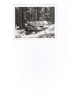 OlympicsShelter
|
| Back to top |
  
|
|
RPBrown
Member
Joined: 14 Aug 2005
Posts: 126 | TRs | Pics
|
|
RPBrown
Member
|
Mon Jul 06, 2009 8:57 pm |
|
|
Apparently not. Shelter Rock, Big Quil.
|
| Back to top |
|
|
RPBrown
Member
Joined: 14 Aug 2005
Posts: 126 | TRs | Pics
|
|
RPBrown
Member
|
Tue Jul 07, 2009 8:51 am |
|
|
There wasn't?
It stood in the main camp flat in between all those big hemlocks.
I'm surprised some old timers on here didn't chime in. Maybe eventually someone will run across the post. I'd like to know more about it myself.
|
| Back to top |
|
|
RPBrown
Member
Joined: 14 Aug 2005
Posts: 126 | TRs | Pics
|
|
RPBrown
Member
|
Sun Jul 19, 2009 5:40 am |
|
|
The Shelter Rock shelter stood there for at least 40 years and probably longer than that. I believe it disappeared in the mid 60's. When I say "stood there", I mean right where the main Shelter Rock camp is nowadays. The old trail crossed the river just a short ways above there.
I think it was built by the Forest Service around the turn of the century, but I have no way to prove that. Several reasons lead me to that conclusion but again that's mainly my opinion. It was a fairly large structure...approximately 1.5 - 2X as large as a standard CCC shelter.
Lots of history in that area (Big Quil/Dungeness) that is mostly gone forever. I've reliably traced that there was a trail up "the Big River" (what they used to call the Big Quilcene) as far back as 1891. The trail up the Little River was built in 1903-1904 to access the mines.
|
| Back to top |
|
|
reststep
Member
Joined: 17 Dec 2001
Posts: 4757 | TRs | Pics
|
|
reststep
Member
|
Mon Jul 20, 2009 1:17 pm |
|
|
Thank you for the info. I have often wondered if there was ever a trail that followed the river up from Shelter Rock Camp.
I may have to give that route a try sometime. It would probably be a real brush bash.
"The mountains are calling and I must go." - John Muir
"The mountains are calling and I must go." - John Muir
|
| Back to top |
|
|
RodF
Member

Joined: 01 Sep 2007
Posts: 2593 | TRs | Pics
Location: Sequim WA |
|
RodF
Member
|
Mon Jul 20, 2009 2:28 pm |
|
|
| reststep wrote: | | I have often wondered if there was ever a trail that followed the river up from Shelter Rock Camp. |
The 1930 map shows the trail crossing to the south side of the Big Quilcene River just above Shelter Rock Camp, then recrossing to the north side about 1/4 mile above (west) of that. I suspect most, perhaps all, of that section was probably taken out by the river, forcing the "new" trail to be built higher on the north side. (Another section, just above Wet Weather Creek (in the vicinity of the current upper Big Quil trailhead) was also on the south side of the river.) The 1938 and later maps show the entire Big Quilcene trail as staying on the north side of the river from Bark Shanty past Camp Mystery.
Neither the 1930 nor 1948 ONF maps nor the USGS 1938 Mt. Constance nor 1947 sectional depict any shelter, Guard Station, cabin or any structure at Shelter Rock. That doesn't mean it wasn't there, but suggests it might more likely have been privately built, by the Tubal Cain Mine packers or by hunters, not by the government? I suggest this possibility because many other private cabins in the area (for example, on the Little Quil, Dungeness and Heather Creeks and at Tull City itself) weren't depicted on most maps, but all the government shelters and guard stations seemed to be.
"of all the paths you take in life, make sure a few of them are dirt" - John Muir
"the wild is not the opposite of cultivated. It is the opposite of the captivated - Vandana Shiva
"of all the paths you take in life, make sure a few of them are dirt" - John Muir
"the wild is not the opposite of cultivated. It is the opposite of the captivated - Vandana Shiva
|
| Back to top |
|
|
reststep
Member
Joined: 17 Dec 2001
Posts: 4757 | TRs | Pics
|
|
reststep
Member
|
Wed Jul 22, 2009 9:26 am |
|
|
Interesting stuff. Thank you for posting Rod.
"The mountains are calling and I must go." - John Muir
"The mountains are calling and I must go." - John Muir
|
| Back to top |
|
|
RPBrown
Member
Joined: 14 Aug 2005
Posts: 126 | TRs | Pics
|
|
RPBrown
Member
|
Mon Aug 17, 2009 10:24 pm |
|
|
Thanks Rod. Legend has it the original trail up the Big River crossed and recrossed the river 57 times. A lot of that occurred in the main canyon but also on up above. Yep, I'm aware the Shelter Rock shelter isn't on any maps. I'm also very familiar with most of the structures in the general area. Tull City, Copper City, Iron Mtn Camp, and the Crow's Nest Hotel were all built by the same mining conglomerate. The cabins you mentioned up the Dungeness/Heather Creek were all private. The fact that the Shelter Rock shelter was so large and on a main trail (it was a main trail at the turn of the century) seems odd to me. I know the gentlemen (know of him, he's been dead 60 years) that had most of the claims on the Upper Big Quil. His cabin was one of those half-cabin affairs with a tent roof that was located half-way up Tull Canyon. He drilled two tunnels in the vicinity of Tull Pass, two shallow ones on Mt. Worthington and two (that I know of) that are down in the timber but upstream from Shelter Rock. In those days the country was freshly burnt and very open.
The Shelter Rock shelter was built, well, like a public dwelling. No glass was in the windows, no shutters on the windows, no door.....most miners would probably have shutters on the windows and a door to latch closed. Also, the thing was built out of HUGE logs. Next time you go by Shelter Rock take a look at the ancient stumps that were cut down to build the cabin. Plus, it was right on the main trail. Miners were generally secretive by nature. Even in the early days people were riding their horses up there. Personally, I think it was built during the Col Whitehead era for the public to use. You also have to realize the USFS isn't exactly known for record keeping. I was chatting with the guy who built the new bridge over the Dungeness and they couldn't tell him (even a ballpark guess) when the previous bridge was built. I told him I was pretty sure it was there in 1983 but wasn't sure before that.
Anyway, appreciate all the information Rod. I'll keep hunting. Maybe someone on here will eventually be able to shed some light.
|
| Back to top |
|
|
RodF
Member
Joined: 01 Sep 2007
Posts: 2593 | TRs | Pics
Location: Sequim WA |
|
RodF
Member
|
Wed Aug 19, 2009 12:06 am |
|
|
| RPBrown wrote: | | ...I was chatting with the guy who built the new bridge over the Dungeness and they couldn't tell him (even a ballpark guess) when the previous bridge was built. |
It was last replaced in 1969, according to Don Stoneman, who remembers talking to the contractor when leading his Eagle Scout troop up to Camp Handy that year. The original footbridge at that location dates from the 1930s.
Shelter Rock cabin is a mystery... it was clearly a major structure, should be a record of it somewhere! Next winter, I'll ask at Quilcene RS if there are any archival records they haven't thrown out, and also spend a day in the Camp Parsons library scanning things, and post here.
Its a pleasure to find others who share an interest in the lost history of the Olympics!
"of all the paths you take in life, make sure a few of them are dirt" - John Muir
"the wild is not the opposite of cultivated. It is the opposite of the captivated - Vandana Shiva
"of all the paths you take in life, make sure a few of them are dirt" - John Muir
"the wild is not the opposite of cultivated. It is the opposite of the captivated - Vandana Shiva
|
| Back to top |
|
|
RodF
Member
Joined: 01 Sep 2007
Posts: 2593 | TRs | Pics
Location: Sequim WA |
|
RodF
Member
|
Thu Aug 27, 2009 5:38 pm Dodger Point Lookout, Olympic NP
|
|
|
Photos of Dodger Point Lookout, Olympic National Park, by Bruce Klanke, 2006. Its history
Faintly pencilled in on the Elwha ranger party line ring list is "Wavmilla Lodge". Could this have been "Doc" Ludden's "Geyser Valley House" hostelry, later operated by E. O. Michael 1927-37? Elwha history Or was it the Glines Canyon Dam or Elwha RS bunkhouse?
"of all the paths you take in life, make sure a few of them are dirt" - John Muir
"the wild is not the opposite of cultivated. It is the opposite of the captivated - Vandana Shiva
"of all the paths you take in life, make sure a few of them are dirt" - John Muir
"the wild is not the opposite of cultivated. It is the opposite of the captivated - Vandana Shiva
|
| Back to top |
|
|
RPBrown
Member
Joined: 14 Aug 2005
Posts: 126 | TRs | Pics
|
|
RPBrown
Member
|
Thu Aug 27, 2009 9:05 pm |
|
|
Rod,
Could that be the Wamilla Inn? It was located 5 miles from Whiskey Bend near where the present day Elwha Ranger Station stands.
|
| Back to top |
|
|
RPBrown
Member
Joined: 14 Aug 2005
Posts: 126 | TRs | Pics
|
|
RPBrown
Member
|
Thu Aug 27, 2009 9:40 pm |
|
|
Definitely very fuzzy history about the Wamilla Inn. All I've been able to find out is it was operated in 1941 by Rhea and Art Shellenberger. I was under the impression that it stood basically where the current Elwha Ranger Station stands. In other words, it predated the ranger station. But that obviously isn't the case since the ranger station was built in 1932.
Interesting Jim. I didn't know the C's built it.
|
| Back to top |
|
|
RodF
Member
Joined: 01 Sep 2007
Posts: 2593 | TRs | Pics
Location: Sequim WA |
|
RodF
Member
|
Thu Aug 27, 2009 9:59 pm |
|
|
You guys are amazing! So Wamilla was the former CCC Elwha work station bunkhouse!
I am sorry to report that the two prefab shelters stored there (once destined for Low Divide and Home Sweet Home) were dismantled and recycled for lumber for various Park projects in March. (Friends ONP attempted to intervene, suggesting a long list of frontcountry sites for them, but superintendent reported decision was taken before her tenure without her knowledge, and materials had already been put to good use. No use crying over spilt milk, but alas.)
"of all the paths you take in life, make sure a few of them are dirt" - John Muir
"the wild is not the opposite of cultivated. It is the opposite of the captivated - Vandana Shiva
"of all the paths you take in life, make sure a few of them are dirt" - John Muir
"the wild is not the opposite of cultivated. It is the opposite of the captivated - Vandana Shiva
|
| Back to top |
|
|
RodF
Member
Joined: 01 Sep 2007
Posts: 2593 | TRs | Pics
Location: Sequim WA |
|
RodF
Member
|
Wed Sep 02, 2009 8:30 pm |
|
|
The "Smith Place", on George Shaube's 1923 homestead 5 miles up the Queets Trail, just below Tshletshy Creek. See George Shaube bio, Queets history and notes, early photos
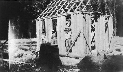 Shaube cabin 1923 courtesy Michael Lujan 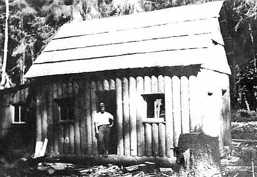 Shaube cabin 1923 courtesy Michael Lujan 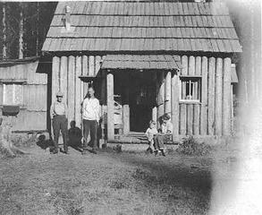 Shaube cabin 1923 courtesy Michael Lujan 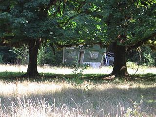 Smith Place 2006 by Gary Patton 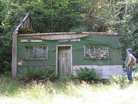 Smith Place 2006 by Gary Patton 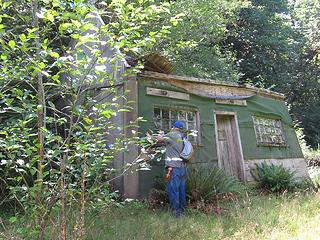 Smith Place 2006 by Gary Patton 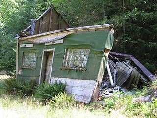 Smith Place 2006 by Gary Patton 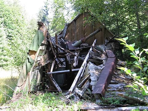 Smith Place 2006 by Gary Patton 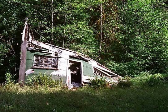 Smith Place 2009 by Ski 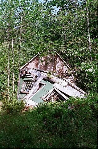 Smith Place 2009 by Ski
"of all the paths you take in life, make sure a few of them are dirt" - John Muir
"the wild is not the opposite of cultivated. It is the opposite of the captivated - Vandana Shiva
"of all the paths you take in life, make sure a few of them are dirt" - John Muir
"the wild is not the opposite of cultivated. It is the opposite of the captivated - Vandana Shiva
|
| Back to top |
|
|
RodF
Member
Joined: 01 Sep 2007
Posts: 2593 | TRs | Pics
Location: Sequim WA |
|
RodF
Member
|
Wed Sep 02, 2009 9:37 pm |
|
|
Andrews Barn, in Andrews Field, 1.7 miles up the Queets Trail. Photos courtesy of Gary Patton, Juneau AK.
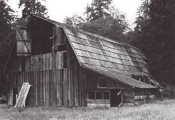 Andrews Barn, unknown date/origin 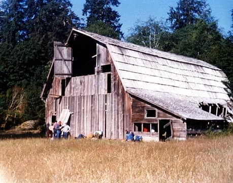 Andrews Barn 1982 by Gary Patton 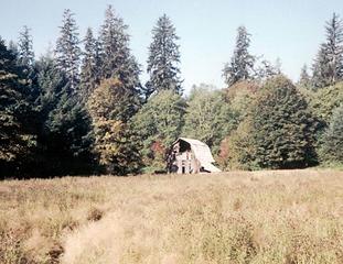 Andrews Barn 1987 by Gary Patton
"of all the paths you take in life, make sure a few of them are dirt" - John Muir
"the wild is not the opposite of cultivated. It is the opposite of the captivated - Vandana Shiva
"of all the paths you take in life, make sure a few of them are dirt" - John Muir
"the wild is not the opposite of cultivated. It is the opposite of the captivated - Vandana Shiva
|
| Back to top |
|
|
|
|
You cannot post new topics in this forum
You cannot reply to topics in this forum
You cannot edit your posts in this forum
You cannot delete your posts in this forum
You cannot vote in polls in this forum
|
Disclosure: As an Amazon Associate NWHikers.net earns from qualifying purchases when you use our link(s). |


