| Previous :: Next Topic |
| Author |
Message |
peltoms
Member


Joined: 13 Jul 2006
Posts: 1760 | TRs | Pics
Location: Worcester MA |
|
peltoms
Member
|
 Tue Jan 15, 2008 9:08 am |
|
|
This year has seen a great deal of snowfall, particularly at lower elevations. A comparison of % of normal snowpack water equivalent and elevation indicate near normal snowpack above 6000 feet and close to twice normal at 3000 feet and even more than twice normal below that point. Though I will dig up more data for lower sites as it becomes available.. This year as of 1/15 is summarized at 2008 1/15 prognosis. Take a look at the maps showing the development day by day of snowpack this winter in the North Cascades you can choose from several variables to view. It takes 15 seconds of so to start but then goes fast through the days, stop anyday you want. It is fun  Northwest snowpack maps Northwest snowpack maps
|
| Back to top |
  
|
|
yukon222
Member

Joined: 12 Mar 2007
Posts: 1893 | TRs | Pics
|
|
yukon222
Member
|
Tue Jan 15, 2008 9:14 am |
|
|
This has certainly been the snowiest winter I can recall in North Bend (30 miles east of Seattle) at 1100' (foothills above the town). I'd estimate I've had probably 45" fall already this winter. Picked up another 4" last night. Had storms come in and dump 15", 8", 6", 5" and a bunch of 1" to 3" events.
Hasn't gotten very cold - perhaps only 26° or so all winter. Haven't had any of those cold clear days where it gets down to the upper teens. All the snow has dropped when it has been 30° or 31°.
|
| Back to top |
|
|
Nordic
Member

Joined: 04 Sep 2007
Posts: 390 | TRs | Pics
Location: North Bend |
|
Nordic
Member
|
Tue Jan 15, 2008 9:53 am |
|
|
It's too bad that the snow never lasts here (NB) for more than a day or two...
It looks pretty nice today and assuming that it doesn't warm up much during the day it should stay for a while.
|
| Back to top |
|
|
wildernessed
viewbagger

Joined: 31 Oct 2004
Posts: 9275 | TRs | Pics
Location: Wenatchee |
We have a 2' base in our yard in Wenatchee at 860'.
Living in the Anthropocene
Living in the Anthropocene
|
| Back to top |
|
|
Conrad
Meadow bagger
Joined: 25 Aug 2006
Posts: 2298 | TRs | Pics
Location: Moscow, ID |
|
Conrad
Meadow bagger
|
Tue Jan 15, 2008 10:38 am |
|
|
Snowiest winter in years here in Moscow ID at 2500'. Many driveway shovelings. Got maybe 6" new last night (hard to tell with all the drifting).
|
| Back to top |
|
|
peltoms
Member
Joined: 13 Jul 2006
Posts: 1760 | TRs | Pics
Location: Worcester MA |
|
peltoms
Member
|
Tue Jan 15, 2008 10:43 am |
|
|
I love x-c skiing up Moscow Mountain from its base along the snowmobile packed logging roads on the southwest. Even better skiing back down.
|
| Back to top |
|
|
Gabigabs
Trail Breaker

Joined: 07 Nov 2007
Posts: 841 | TRs | Pics
Location: Seattle |
|
Gabigabs
Trail Breaker
|
Tue Jan 15, 2008 10:54 am |
|
|
Not too much in downtown Sultan. We had 1-2" here and there melting fast but it for sure snowed more frequently so far this year than I remember in last 6 years combined.
Up on the hill which is couple hundred feet higher they have about 3-4".
Life is simple... Eat, Sleep, Hike!
Life is simple... Eat, Sleep, Hike!
|
| Back to top |
|
|
Conrad
Meadow bagger
Joined: 25 Aug 2006
Posts: 2298 | TRs | Pics
Location: Moscow, ID |
|
Conrad
Meadow bagger
|
Tue Jan 15, 2008 11:22 am |
|
|
| peltoms wrote: | | I love x-c skiing up Moscow Mountain from its base along the snowmobile packed logging roads on the southwest. Even better skiing back down. |
That's sarcasm, I guess. Is there a weather station or something up there you have to check?
|
| Back to top |
|
|
BeyondLost
Crazy Bob
Joined: 07 Jul 2007
Posts: 3601 | TRs | Pics
Location: Whidbey Island, WA |
We are not a weather station  but I and my neighbors have been trying to keep an accurate measure of the snowfall in the upper Methow Valley where Lost River Road ends and Hart's Pass Road begins, The elevation is 2400 feet. This area always has the highest snowfall in the valley. When I left there on Jan 1 the total I had measured was 8 1/2 feet and my neighbor says just over 22 inches more in the last 13 days.
The highest total for an entire winter that we have measured since 1997 is 12 feet and we are already at 10 1/2 feet with a long way to go. but I and my neighbors have been trying to keep an accurate measure of the snowfall in the upper Methow Valley where Lost River Road ends and Hart's Pass Road begins, The elevation is 2400 feet. This area always has the highest snowfall in the valley. When I left there on Jan 1 the total I had measured was 8 1/2 feet and my neighbor says just over 22 inches more in the last 13 days.
The highest total for an entire winter that we have measured since 1997 is 12 feet and we are already at 10 1/2 feet with a long way to go.
|
| Back to top |
|
|
Mtn Dog
Technohiker
Joined: 01 Aug 2004
Posts: 3336 | TRs | Pics
Location: Bellevue, WA |
|
Mtn Dog
Technohiker
|
Tue Jan 15, 2008 1:58 pm |
|
|
So Peltoms, this data makes me wonder about two things.
Can we discern that the higher amount of snow at lower elevations will be sufficient to recharge our watersheds and reservoirs?
Also, since the higher elevations aren't seeing unusually high amounts of snowfall there still won't be much to help our glaciers this year, will there? Thanks for sharing the information. The other question we're probably all wondering about is whether this will mean an earlier or later snowmelt for hiking season but that will depend on spring rainfall too, among other things.
Footprints on the sands of time will never be made sitting down.
Footprints on the sands of time will never be made sitting down.
|
| Back to top |
|
|
peltoms
Member
Joined: 13 Jul 2006
Posts: 1760 | TRs | Pics
Location: Worcester MA |
|
peltoms
Member
|
Tue Jan 15, 2008 2:38 pm |
|
|
conrad no sarcasm that was my morning excercise before work in 198- when I was working at U of I. The downhill could be a screamer, I love seeing how long I could stay in a tuck. Mtn dog we have had high ppt this winter too, so all reservoirs should be full up. The low level melt if it occurs early will not help too much, as for flood control reasons they cannot fill the reservoirs past a certain point anyway. Reservoirs with large low elevation areas like Baker Lake, Cedar Lake and Tolt Reservoir should be in great shape. I made my forecast for winter two months ago,winter forecast snowy and cool-no forecast for spring yet.
|
| Back to top |
|
|
Schmidt Alti-Dude
4th class poster
Joined: 06 Jul 2007
Posts: 1361 | TRs | Pics
Location: Looking for Adventure 201! |
No snow in sunny Sequim. We can see it all over the Olympics but we just received a very light dusting last night in the valley.
Anything stated by me in no way reflects the attitudes or opinions of my wife
Anything stated by me in no way reflects the attitudes or opinions of my wife
|
| Back to top |
|
|
Conrad
Meadow bagger
Joined: 25 Aug 2006
Posts: 2298 | TRs | Pics
Location: Moscow, ID |
|
Conrad
Meadow bagger
|
Tue Jan 15, 2008 4:29 pm |
|
|
| peltoms wrote: | | conrad no sarcasm |
Oh OK, I was just remembering experiences skiing icy-hard logging roads.
|
| Back to top |
|
|
Mega-Will
country bumpkin

Joined: 22 Dec 2006
Posts: 655 | TRs | Pics
Location: Olympic Peninsula |
|
Mega-Will
country bumpkin
|
Tue Jan 15, 2008 10:22 pm |
|
|
I was very surprized to see a solid 3 feet (or maybe more) of snow in Newhalem (just under 500ft.) last Sunday. I know it's relatively far east, but still... They had the Skagit Gorge portion of the highway closed because of avalanches!
|
| Back to top |
|
|
Scrooge
Famous Grouse

Joined: 16 Dec 2001
Posts: 6966 | TRs | Pics
Location: wishful thinking |
|
Scrooge
Famous Grouse
|
Wed Jan 16, 2008 12:10 am |
|
|
Peltoms said | Quote: | | Take a look at the maps showing the development day by day of snowpack this winter in the North Cascades you can choose from several variables to view. It takes 15 seconds of so to start but then goes fast through the days, stop anyday you want. It is fun. Northwest snowpack maps |
Hmmmm.  It is fun, kind of, but mostly it's a little overwhelming. The amount of information being made available these days is staggering.
You can start with peltom's "fun maps" and go into a little detail on each or the 3000 odd National Hydrologic Remote Sensing Sites that provide the data to produce those nice time-lapse maps.
Start with a link to Google Earth, and a special overlay that pinpoints those remote sensing sites. It is fun, kind of, but mostly it's a little overwhelming. The amount of information being made available these days is staggering.
You can start with peltom's "fun maps" and go into a little detail on each or the 3000 odd National Hydrologic Remote Sensing Sites that provide the data to produce those nice time-lapse maps.
Start with a link to Google Earth, and a special overlay that pinpoints those remote sensing sites.
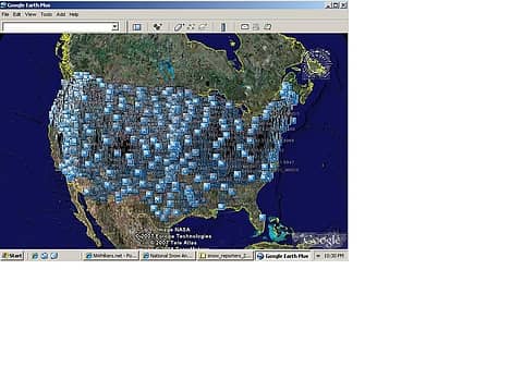 Google Earth view of the sites that provide the snowpack information 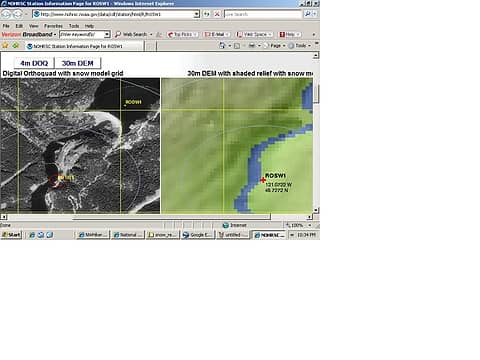 Ross Dam remote sensing site shown on a LanSat digital photo and on a map produced from that photo. 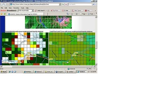 A little more detail about the nature of the forest and ground cover in the vicinity of the Ross Dam site. 
Something lost behind the ranges. Lost and waiting for you....... Go and find it. Go!
Something lost behind the ranges. Lost and waiting for you....... Go and find it. Go!
|
| Back to top |
|
|
|
|


