| Previous :: Next Topic |
| Author |
Message |
wildernessed
viewbagger


Joined: 31 Oct 2004
Posts: 9275 | TRs | Pics
Location: Wenatchee |
Location : Just North of Blewett Pass
Access : SR 97 > Forest Road 7240 to TH at the end.
Maps: GTM - Liberty
Stats : 7.2 mi, 2000', 5.25 hr. r/t
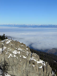
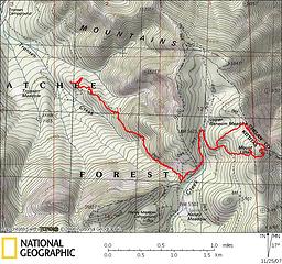 Lillian Ridge - Peak and Highpoints  . We alloted enough time for winter travel and were armed with COLD weather gear and snowshoes . We alloted enough time for winter travel and were armed with COLD weather gear and snowshoes  . We had to get above the fog dome to see if the skies were still blue.
We were on the trail at 0810 under blue skies (above around 3000'), mid-teen temps, gaining the needed elevation before the sun broke over the ridge. There was 2-4" of snow on the trail and we made several miles or so to a forest road, at around 5500' it looked like you could still drive FR 5700 from Blewet, we crossed through some forest to another road and took the packed down road to a little NW of Mt. Lillian and gained the higher ridge off trail with easy cross country travelling... . We had to get above the fog dome to see if the skies were still blue.
We were on the trail at 0810 under blue skies (above around 3000'), mid-teen temps, gaining the needed elevation before the sun broke over the ridge. There was 2-4" of snow on the trail and we made several miles or so to a forest road, at around 5500' it looked like you could still drive FR 5700 from Blewet, we crossed through some forest to another road and took the packed down road to a little NW of Mt. Lillian and gained the higher ridge off trail with easy cross country travelling...
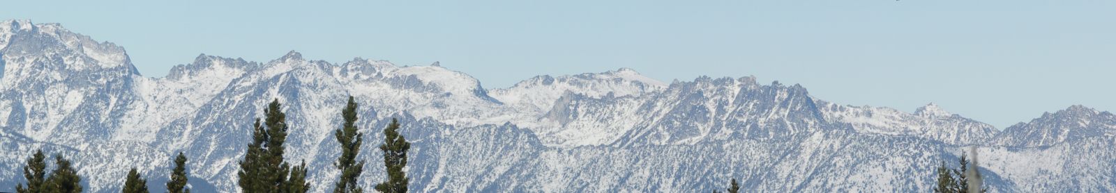
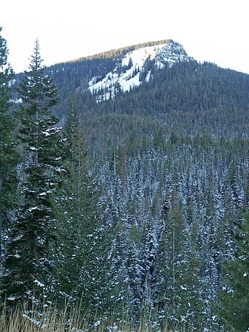 Diamondhead from across Tronsen Meadows. 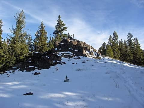 This looks like the right way. 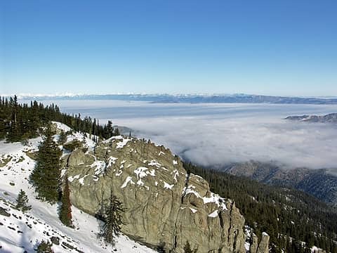 Fog covered foothills Northeast of Lillian Ridge. 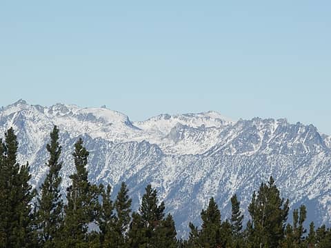 Upper Enchantments 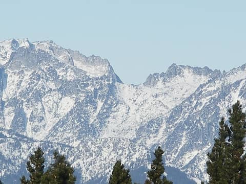 Enchantment Peaks, Prussik Pass, and Prussik Peak. 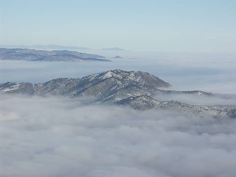 Horse Lake Mountain aka Twin Peaks sticks out of the fog with Burch Mtn. in the background. 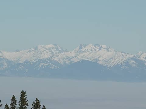 Phelps Creek Drainage with Entiat Ridge right and Chiwawa Ridge left ? 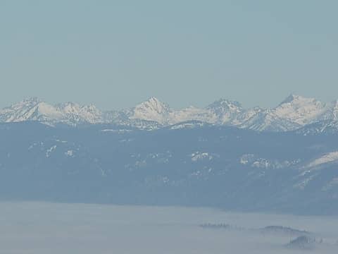 (L to R) Duncan Hill, Pinnacle Peak, Choral Peak, Gopher Peak, Saska Peak, Emerald Peak, Cardinal Peak. 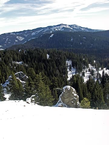 South side of Mission Peak. 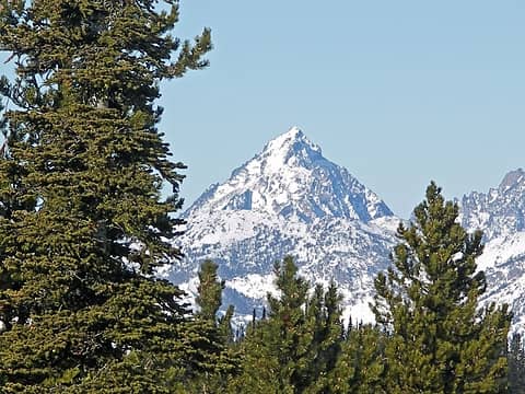 Mt. Stuart 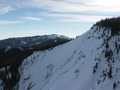 Mt. Lillians East face with Mission Peak in the background. 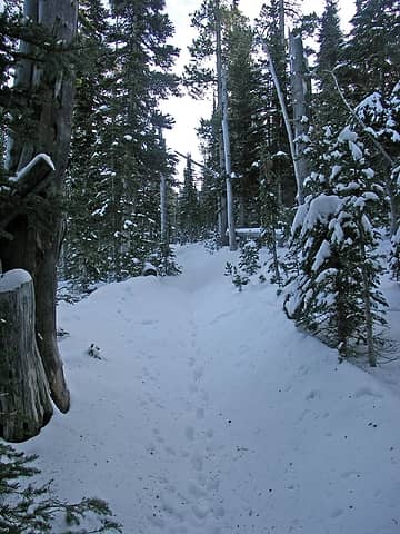 Trail in the summit area.  Mt. Lillian summit area. 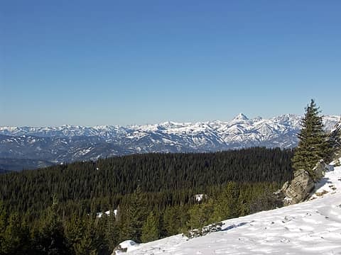 WOW ! 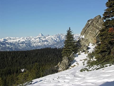 SWEET ! 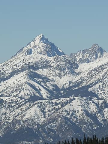 Iron Mtn., Three Brothers Mtn., Mt. Stuart, and Colchuck Peak. 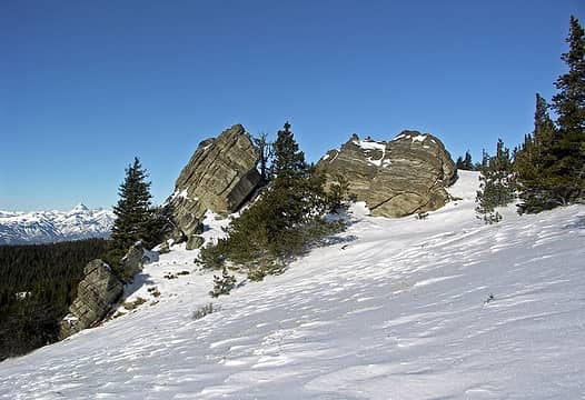 Lillian Ridge rock formations with Stuart Range in the background. 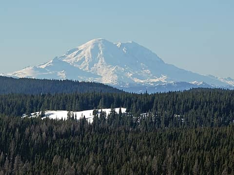 Mt. Rainier 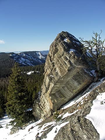 Rock formation on Lillian Ridge with Diamondhead Mtn. in the background. 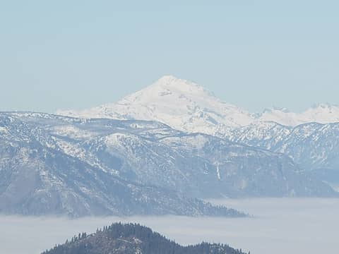 Glacier Peak 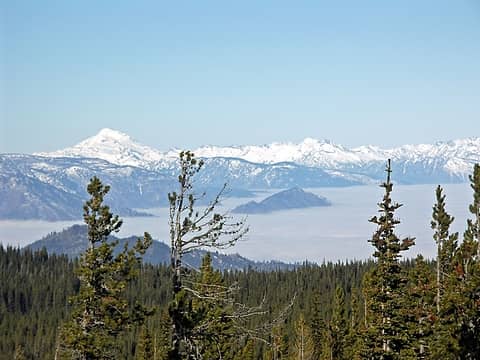 Glacier Peak and company. 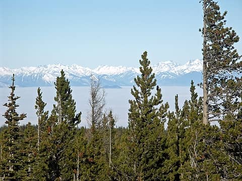 Peaks of the North Entiat / Glacier Peak Wilderness. 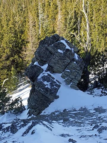 Rock formation along ridge. 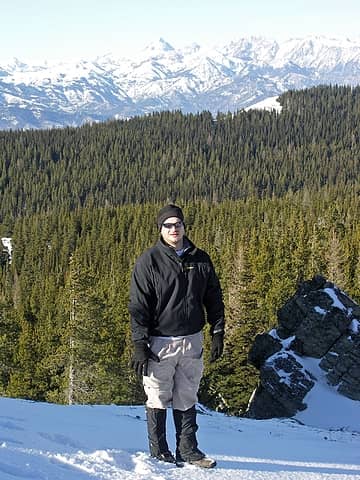 Kyled with Tronsen Meadows and Stuart Range in the background. 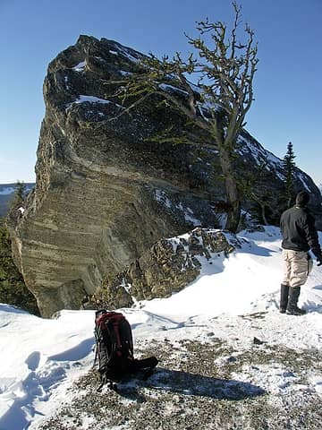 6000' plus highpoint with neat rock formations NW of Lillian Peak. 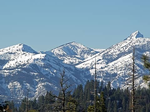 Looking up North Shaser Creek Valley at Iron Mountain Pass (center), Miller Peak (left), Navaho Peak (Center), Iron Mountain, Three Bro. West summit area, and the top of Mt. Stuart.  . Great vantage point . Great vantage point  . From there we dropped down several hundred feet, then followed our initial route back. I was fairly surprised to see only about 1' of snow at 6100-6200'. . From there we dropped down several hundred feet, then followed our initial route back. I was fairly surprised to see only about 1' of snow at 6100-6200'.
Living in the Anthropocene
Living in the Anthropocene
|
| Back to top |
  
|
|
wildernessed
viewbagger
Joined: 31 Oct 2004
Posts: 9275 | TRs | Pics
Location: Wenatchee |
 Enchantmenyspano1  Lillian Ridgepano2  Lillianridgepano3
Living in the Anthropocene
Living in the Anthropocene
|
| Back to top |
|
|
Get Out and Go
Member

Joined: 13 Nov 2004
Posts: 2128 | TRs | Pics
Location: Leavenworth |
Wow...You guys had incredible visibility today. No haze at all on your zoom shot of Ranier. Your "SWEET" picture is a keeper. Great day to pull above the cloud/fog deck. I hit blue skies at about Johnny Creek up the Icicle....Descended back into the funk to come home.
"These are the places you will find me hiding'...These are the places I will always go."
(Down in the Valley by The Head and The Heart)
"Sometimes you're happy. Sometimes you cry.
Half of me is ocean. Half of me is sky."
(Thanks, Tom Petty)
"These are the places you will find me hiding'...These are the places I will always go."
(Down in the Valley by The Head and The Heart)
"Sometimes you're happy. Sometimes you cry.
Half of me is ocean. Half of me is sky."
(Thanks, Tom Petty)
|
| Back to top |
|
|
wildernessed
viewbagger
Joined: 31 Oct 2004
Posts: 9275 | TRs | Pics
Location: Wenatchee |
| Get Out and Go wrote: | | Wow...You guys had incredible visibility today. No haze at all on your zoom shot of Ranier. Your "SWEET" picture is a keeper. Great day to pull above the cloud/fog deck. I hit blue skies at about Johnny Creek up the Icicle....Descended back into the funk to come home. |
Great scenery on both E and W sides of the ridge. Sometimes the best vantage point isn't from the summit, but an arms length away. This is a awesome Jan. - Feb. snowshoe. Actionbetty and I did one from Blewett to a 6000' highpoint just E of Diamondhead last winter, the blue skies and clarity was gorgeous. 
Living in the Anthropocene
Living in the Anthropocene
|
| Back to top |
|
|
kyle d
Member

Joined: 03 Jun 2007
Posts: 521 | TRs | Pics
Location: Ogden, UT |
|
kyle d
Member
|
 Mon Nov 26, 2007 10:18 pm |
|
|
Nice report, especially enjoyed all the panormas. Looking at a wildlife guidebook makes me lean even more toward those prints we saw being mountain lion  Looks like those side roads from Blewett may not be as accessible next weekend with the snow we are getting tonight in Wenatchee.
Here are some of my pictures from the trip (the last couple are from an evening drive up Mission Ridge to get above the inversion a little more Looks like those side roads from Blewett may not be as accessible next weekend with the snow we are getting tonight in Wenatchee.
Here are some of my pictures from the trip (the last couple are from an evening drive up Mission Ridge to get above the inversion a little more 
 Inversion over the Wenatchee valley from Mt. Lillian 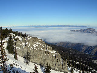 Inversion over the Wenatchee valley from Mt. Lillian  Twin Peaks and inversion over the Wenatchee Valley 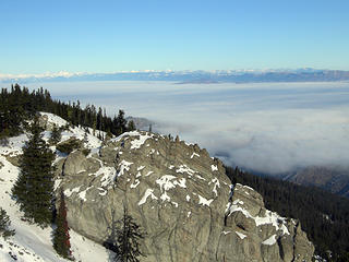 Inversion over the Wenatchee valley from Mt. Lillian 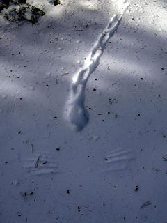 Grouse? takeoff leaves wingprints in the snow 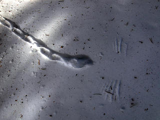 Grouse? takeoff leaves wingprints in the snow 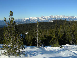 Stuart Range from Mt Lillian 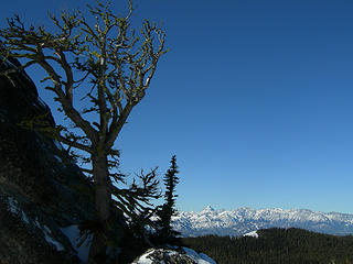 Snag with Stuart Range beyound from Lilian 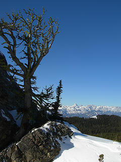 Snag with Stuart Range beyound from Lilian 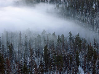 Incoming fog at mission ridge 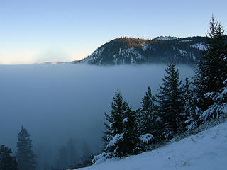 Inversion
|
| Back to top |
|
|
puzzlr
Mid Fork Rocks

Joined: 13 Feb 2007
Posts: 7220 | TRs | Pics
Location: Stuck in the middle |
|
puzzlr
Mid Fork Rocks
|
Tue Nov 27, 2007 12:02 am |
|
|
I like the way you framed this, and it really is a cool looking rock.
|
| Back to top |
|
|
ActionBetty
Im a dirty hippie!

Joined: 06 Jul 2003
Posts: 4807 | TRs | Pics
Location: kennewick, wa |
|
ActionBetty
Im a dirty hippie!
|
Tue Nov 27, 2007 12:20 am |
|
|
Is that same area we did last year when we thought we were on Diamondhead?
"If you're not living good, you gotta travel wide"...Bob Marley
"If you're not living good, you gotta travel wide"...Bob Marley
|
| Back to top |
|
|
wildernessed
viewbagger
Joined: 31 Oct 2004
Posts: 9275 | TRs | Pics
Location: Wenatchee |
| ActionBetty wrote: | | Is that same area we did last year when we thought we were on Diamondhead? |
Same area, but the other side of Tronsen Meadows , in the Haney Meadow area. Last year we were on the East slope of Diamondhead, but due to the deep unconsolidated snow (thigh deep with snowshoes) we crossed below the saddle to the unnamed 6000' highpoint.
Last years snowshoe to Point 6000' above Tronsen Meadows
Living in the Anthropocene
Living in the Anthropocene
|
| Back to top |
|
|
ActionBetty
Im a dirty hippie!
Joined: 06 Jul 2003
Posts: 4807 | TRs | Pics
Location: kennewick, wa |
|
ActionBetty
Im a dirty hippie!
|
Tue Nov 27, 2007 9:38 am |
|
|
way cool.. I will have to explore those roads around that area more.
Nice pics my friend
"If you're not living good, you gotta travel wide"...Bob Marley
"If you're not living good, you gotta travel wide"...Bob Marley
|
| Back to top |
|
|
Philthy Phil
Member
Joined: 14 Jul 2007
Posts: 258 | TRs | Pics
Location: Apple Capital of the World |
Philthy Phil wrote:
Man...you are one mountain goat! I wish I had your youth and energy. I had planned to do what you're doing following retirement but a medical misfortune pretty much ruined that. If you haven't already, I'd suggest your putting Lake Elsey on next season's calendar. I was there in '96 (one of the tougher ones) and got some great views of Glacier Peak, the White Mtns, and looking DOWN at A-6 Intruders flying up the Napequa Valley. Your reports and pics are great!
|
| Back to top |
|
|
wildernessed
viewbagger
Joined: 31 Oct 2004
Posts: 9275 | TRs | Pics
Location: Wenatchee |
| Philthy Phil wrote: | | Philthy Phil wrote:
Man...you are one mountain goat! I wish I had your youth and energy. I had planned to do what you're doing following retirement but a medical misfortune pretty much ruined that. If you haven't already, I'd suggest your putting Lake Elsey on next season's calendar. I was there in '96 (one of the tougher ones) and got some great views of Glacier Peak, the White Mtns, and looking DOWN at A-6 Intruders flying up the Napequa Valley. Your reports and pics are great! |
Thanx P2, I'll have to investigate that area. Here are some pics from the websh&ts album

Living in the Anthropocene
Living in the Anthropocene
|
| Back to top |
|
|
|
|


