| Previous :: Next Topic |
| Author |
Message |
Bryan K
Shameless Peakbagger


Joined: 29 Sep 2005
Posts: 5129 | TRs | Pics
Location: Alaska |
|
Bryan K
Shameless Peakbagger
|
 Tue Dec 04, 2007 8:02 pm |
|
|
After stopping at the strip mall located REI store in Issaquah I was off to SR 900 and the Wilderness Creek TH. There was one other car when I got there and 900 was "pretty" quiet.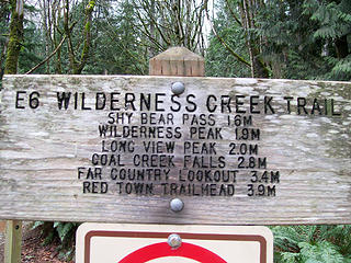 Sign at trailhead 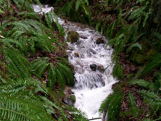 Wilderness Creek 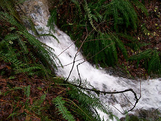 Wilderness Creek 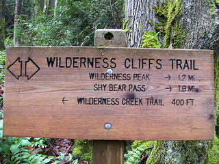 Sign 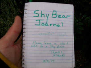 Register at the Wilderness Peak summit. 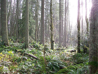 Sun peaking through the clouds 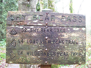 Shy Bear Pass  After 10 minutes I headed to the pass and back down the Wilderness Creek Trail "E6" to the trailhead.
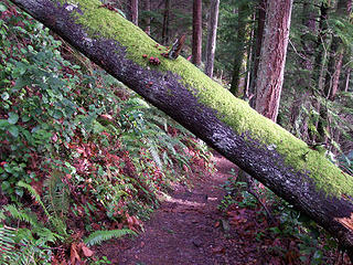 Limbo under the tree 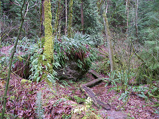 Pathway around big boulders along the Wilderness Creek Trail 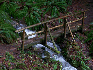 Creek crossing on Wilderness Creek Trail
|
| Back to top |
  
|
|
Magellan
Brutally Handsome

Joined: 26 Jul 2006
Posts: 13116 | TRs | Pics
Location: Inexorable descent |
|
Magellan
Brutally Handsome
|
Tue Dec 04, 2007 11:53 pm |
|
|
I can't believe you didn't spend hours in that register, eventually locating my name from early this year.
|
| Back to top |
|
|
hysteresis
...

Joined: 11 Apr 2007
Posts: 3 | TRs | Pics
Location: West Seattle and/or College Station, TX |
aww... that was my first hike last march!  man I can't wait for summer...
|
| Back to top |
|
|
Sabahsboy
Member

Joined: 18 Jul 2006
Posts: 2484 | TRs | Pics
Location: SW Sno County |
|
Sabahsboy
Member
|
Wed Dec 05, 2007 8:25 pm Cougar Mountain Park
|
|
|
Ah, Wilderness! Shy Bear Pass is a favorite place. continue on toward Far Country for some nice woodland walking. Anyone get photos of Coal Creek Falls during this rain event or shortly after? The first hundred yards or so of Wilderness Peak Trail displays the first trilliums of spring, few in number but most welcome.
|
| Back to top |
|
|
fettster
Member
Joined: 29 Apr 2007
Posts: 182 | TRs | Pics
Location: Hillsboro, OR |
|
fettster
Member
|
Wed Dec 05, 2007 11:09 pm |
|
|
| Magellan wrote: | | I can't believe you didn't spend hours in that register, eventually locating my name from early this year. |
And I'm glad you didn't spend hours looking for mine. Nice trip outdoors. Bryan, what's the story on "Red Town" in the trail sign? Don't think I've seen "town" on a trail sign before.
|
| Back to top |
|
|
Bryan K
Shameless Peakbagger
Joined: 29 Sep 2005
Posts: 5129 | TRs | Pics
Location: Alaska |
|
Bryan K
Shameless Peakbagger
|
Thu Dec 06, 2007 12:21 am |
|
|
| fettster wrote: | | Bryan, what's the story on "Red Town" in the trail sign? Don't think I've seen "town" on a trail sign before. |
The "Red Town Trailhead" is located at the hairpin curve where Lakemont Blvd meets Newcastle Coal Creek Road. There is a trail there that passes by the Red Town dam site. Here is a link that briefly mentions Red Town.
|
| Back to top |
|
|
Sabahsboy
Member
Joined: 18 Jul 2006
Posts: 2484 | TRs | Pics
Location: SW Sno County |
|
Sabahsboy
Member
|
Thu Dec 06, 2007 7:11 pm Ghost Town Web site
|
|
|
Most interesting. However, more information could be added, i.e., the locomotive turntable at Monte Cristo and the "road" to Glacier Basin and the mines there; ref. to the RR and Everet and the remnant tunnels of Robe Canyon.
Years ago I went to "Red Town" fairly frequently to see in interesting "ruins"; there was not much. The Red Town parking area offers trail routes to various places and loops. One is interesting and short...to the old ball field, now restored to native species with a "trail"...sort of an interpretive trail through the field. There is a nice interpretive sign there, too. There is an old horse watering trough not far before you reach the "field".
Resident coyotes are about; bears can be seen or sensed in early summer; I have heard a cougar scream...and was told by several parties that they had seen the creature (this, several years ago). Most awesome is to realize that nearly all of Cougar was urbanized, then abandoned and returned to "nature". The place has ghosts everywhere.
I think Cougar is best in winter and early - mid-spring. When winter sun is near setting, it illuminates the alders in a way hard to describe. When walking there, you may see remains of items like cables, electric power poles, etc. Sure wish the county had seen the area around the Park as a green belt - buffer and not allowed the development, some of which seems to creep deep into the parklands. Not long ago you might hear distant city noise, but it never seemed close; that is now different with house construction and new residents making the usual, citified noise.
|
| Back to top |
|
|
boot up
Old Not Bold Hiker

Joined: 12 Dec 2006
Posts: 4745 | TRs | Pics
Location: Bend Oregon |
|
boot up
Old Not Bold Hiker
|
Fri Dec 07, 2007 9:30 pm |
|
|
| Sabahsboy wrote: | | Most interesting. However, more information could be added, i.e., the locomotive turntable at Monte Cristo and the "road" to Glacier Basin and the mines there; ref. to the RR and Everet and the remnant tunnels of Robe Canyon. |
??????????? I obviously missed something...in a string about Cougar mtn.
I agree that Cougar is a good Winter and "antsy to clock some miles" Early Spring area.
We have put together a couple of 10-12 mile loops, creatively hitting the perimeter and weaving together the trails. It is possible. Feels sorta funny setup for a day pack in the rain and cold and see the joggers come and go wearing tiny shorts and tank tops and running shoes, and counting on luck that they don't get hurt and stuck for more than a minute before going into hypothermia. But then we remember that most are usually only hitting it for a mile or two.
|
| Back to top |
|
|
Sabahsboy
Member
Joined: 18 Jul 2006
Posts: 2484 | TRs | Pics
Location: SW Sno County |
|
Sabahsboy
Member
|
Fri Dec 07, 2007 11:13 pm Cougar's joggers
|
|
|
Biggest gripe....the joggers with loose Labs and such. Since I hike with my pups on lead (per LAW), the sudden appearance (usually the dog arrives before the runner....ditto hikers with loose pups) of the canine will throw my dogs into turmoil. Aside of that, I marvel at how these folks don't slide and slip and trip and end up with a busted bum or trashed jaw. I ran for many years and even on some trails, but, there is a logical limit and one really ought to be careful. Never the less, I have never come across a jogger flat out down in wretched pain needing rescue. I guess the Nike gods watch over them.
In my day, the encounters with cats and sidewalk breaks were near lethal. Left a few bloody marks on sidewalks. Nary one on a trail.
|
| Back to top |
|
|
|
|


