| Previous :: Next Topic |
| Author |
Message |
summithound
Climbing Connoisseur

Joined: 26 Jul 2004
Posts: 1766 | TRs | Pics
Location: Everett, WA |
|
summithound
Climbing Connoisseur
|
 Sat Feb 16, 2008 9:22 pm |
|
|
December 29, 2007
--Hike Statistics--
Round-Trip Hiking Distance: 1.5 miles
Elevation Gain: 200 feet
High Point: 250 feet
Weather at Trailhead: light snow and rain
Weather at Cape Flattery: low clouds, light rain and breezy
Makah recreation pass required
--Driving Directions--
From Forks follow US Highway 101 north (paved) for 12.3 miles to Sappho. Turn left onto Highway 113 (paved) for 10.0 miles to the intersection with Highway 112. Continue straight (west) on Highway 112 (paved). Follow Highway 112 for 26.9 miles to the Makah Nation of Neah Bay. Once in town, keep an eye out for Washburn's General Store on the left side of the road. You can buy a required recreation pass from the cashier. From Washburn's, continue west on Bayview Avenue (paved) for 1.0 mile to Fort Street. Stay to the left onto Fort Street (paved) and follow it for 0.1 mile to 3rd Street. Turn right on 3rd Street (paved) and follow it 0.1 mile to Cape Flattery Road. Turn left onto Cape Flattery Road (paved) and follow it to the road's end at 7.6 miles. There are plenty of parking spaces available and a newer looking privy.
--The Experience--
After my long drive from Forks, I was anxious to step boot onto Makah land and make tread to the northwestern-most point of the contiguous United States. There were a couple of cars present in the parking lot on my arrival. Upon shutting off the tired diesel engine and stepping out of the truck I realized that comfort would be a top priority on this hike. There was a chilly wind flowing from the way I had just driven and the rain/snow mix made it difficult to prepare my gear. I found myself sitting in the passenger seat of the truck donning my boots and my Gore-Tex raingear.
Tromping across the parking area, I easily located the trailhead. An old wooden sign nailed high in a sapling near the back of the parking lot pointed in the direction of the Cape Flattery Trail. As if the sign wasnt enough, there was another boarded sign just below reading Cape TrailMost N.W. Point with an arrow pointing towards the trailhead. Giving the large informational kiosk a good once-over a-priori, I was quickly on my way.
The air was damp and the relentless dripping of the rain had completely saturated the trail and all facets of flora alongside. The forest was thick and dark but the trail was wide enough for a party of three or four as it descended from the plateau of the parking lot. Locals had cut circular stepping plates from the trunks of trees which they placed linearly through the muddy portions of the trail, of which there was many. Through the marshier areas were erected raised plank boardwalks paralleled by brushy salal and grass. Photography was difficult in this environment due to the harsh weather conditions and poor lighting.
Large Sitka Spruce adorned with lichen and moss towered overhead as I slowly continued my descent along the narrowing path. I soon reached the first promontory, an observation platform harnessed to the hillside accessed via a short side trail to the left. I stood in awe as I watched and listened to the powerful waves slam into the cliff-like coast of Cape Flattery. Tiny, steeply sided islands dotted the coast and rounded boulders protruded above the waves. The ground beneath my feet vibrated with each powerful blast of water and I was amazed that the tract of land I clung to had not yet been claimed by the sea.
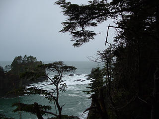 Clinging 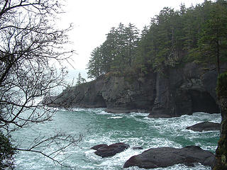 Rounding the Cape 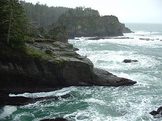 Chaos Below 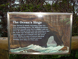 The Ocean's Siege 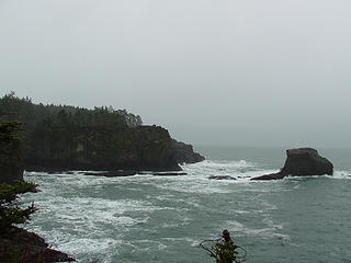 Looking South 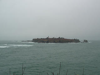 Tatoosh Island
Pain is just weakness leaving the body.
Pain is just weakness leaving the body.
|
| Back to top |
  
|
|
Quark
Niece of Alvy Moore

Joined: 15 May 2003
Posts: 14152 | TRs | Pics
|
|
Quark
Niece of Alvy Moore
|
Sat Feb 16, 2008 9:29 pm |
|
|
Wow, that's cool. Can you really feel the vibration of the ocean in the caves underneath you?
THanks for the report. I have never been to Cape Flattery, and would like to go.
Were you in Forks, or are the directions copied from another source?
[edit: I see you did start from Forks. I love that little town]
"...Other than that, the post was more or less accurate."
Bernardo, NW Hikers' Bureau Chief of Reporting
"...Other than that, the post was more or less accurate."
Bernardo, NW Hikers' Bureau Chief of Reporting
|
| Back to top |
|
|
drewcoll
Member

Joined: 19 Sep 2007
Posts: 288 | TRs | Pics
Location: Seattle |
|
drewcoll
Member
|
Sat Feb 16, 2008 9:30 pm |
|
|
Nice description, the color of the water is too cool.
Not much of the bright thing in the sky though... not like they told us at least. The coast is meant to be rainy like that though.
Good job getting all the way out there today!
|
| Back to top |
|
|
summithound
Climbing Connoisseur
Joined: 26 Jul 2004
Posts: 1766 | TRs | Pics
Location: Everett, WA |
|
summithound
Climbing Connoisseur
|
Sat Feb 16, 2008 9:32 pm |
|
|
| Quark wrote: | | Were you in Forks, or are the directions copied from another source? |
The directions from Forks (where I was staying) to Neah Bay are mine. The directions from Neah Bay to the trailhead are from Day Hiking Olympic Peninsula but verified by me. 
Pain is just weakness leaving the body.
Pain is just weakness leaving the body.
|
| Back to top |
|
|
|
|
You cannot post new topics in this forum
You cannot reply to topics in this forum
You cannot edit your posts in this forum
You cannot delete your posts in this forum
You cannot vote in polls in this forum
|
Disclosure: As an Amazon Associate NWHikers.net earns from qualifying purchases when you use our link(s). |


