| Previous :: Next Topic |
| Author |
Message |
Sadie's Driver
Sadie's Driver


Joined: 24 Apr 2006
Posts: 1763 | TRs | Pics
Location: Welcome Pass |
WOW! What a day. The destination today was Red Top Lookout. I know, I know, big deal! It's only a short 1/2 mile hike - well, yeah, during the summer when you can drive practically to the doorstep! Oh no, this is a good work-out. Nothing scary - well, a couple of challenging spots - but very "doable." But first, some housekeeping:
Thanks, Matt, for your great trip report from last year (posted here on NW Hikers) - we more-or-less followed your route - except where we didn't! It was a heck of a lot warmer today than when you did it! Item #2, we're on a roll now! This is the 4th STRAIGHT successful summit for Jim K and Opus  - Everest here they come! - Everest here they come!  Opus will post the "official" stats, but here's what we figured:
About 9 hours roundtrip (including lunch and breaks) - less than 5 hours to the lookout and about 3 hours 30 minutes out.
About 28 degrees when we started - probably got in upper 30s/low 40s mid-day; they had predicted stiff winds - but we only felt the wind at the summit.
4000 or 4200' of elevation gain
14 to 15 miles distance (car-to-car)
Item #3, this was Middle E's (Barry) FIRST trip in the Teanaways - we'll change that!
We were going to save this trip until after Daylight Savings Time started so we would have more daylight hours, but we were able to do it in daylight. Barry (Middle E), Jim K and I started from the 65th Park and Ride about 6:20 a.m.; Opus, Jack, and Trail Pair started from the S.E. 8th P&R about 6:30 a.m. The weather was predicted to be cloudy - maybe even snowing - in the early morning. Well, when we got to the start along the North Fork of the Teanaway, it was blue sky! We parked at Mile Post 11 on the North Fork Teanaway Road. Opus will post the "official" stats, but here's what we figured:
About 9 hours roundtrip (including lunch and breaks) - less than 5 hours to the lookout and about 3 hours 30 minutes out.
About 28 degrees when we started - probably got in upper 30s/low 40s mid-day; they had predicted stiff winds - but we only felt the wind at the summit.
4000 or 4200' of elevation gain
14 to 15 miles distance (car-to-car)
Item #3, this was Middle E's (Barry) FIRST trip in the Teanaways - we'll change that!
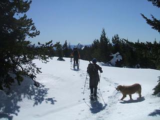
We were going to save this trip until after Daylight Savings Time started so we would have more daylight hours, but we were able to do it in daylight. Barry (Middle E), Jim K and I started from the 65th Park and Ride about 6:20 a.m.; Opus, Jack, and Trail Pair started from the S.E. 8th P&R about 6:30 a.m. The weather was predicted to be cloudy - maybe even snowing - in the early morning. Well, when we got to the start along the North Fork of the Teanaway, it was blue sky! We parked at Mile Post 11 on the North Fork Teanaway Road.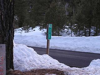 Mile Post 11 - the place to pull over 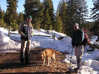 Barry and Jim K with Gusto getting ready 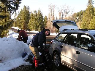 Jack and rest of gang getting ready 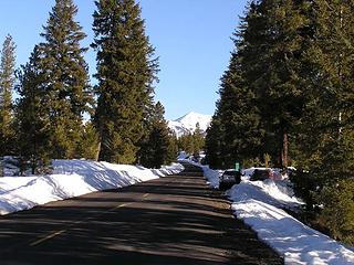 Looking down the Teanaway Road toward Earl 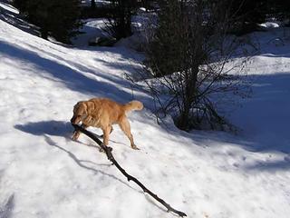 Gusto getting his walking stick - Red Top - 03-08-08 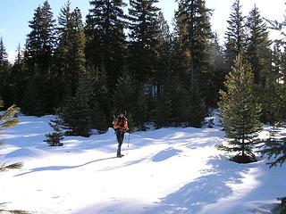 K in the sparkling snow as we head out 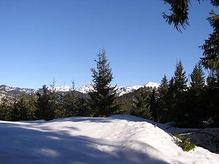 Stuart and Earl as we start out 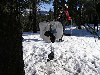 Emergency survival gear hanging from a tree 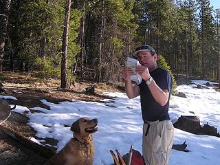 Barry explaining the route to Gus (Gus is only interested in the possibility of a treat) - 03-08-8 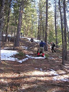 Heading up ridge on dirt  For the most part, our ridge walks were up!!! (We had to gain that 4000' somehow.) Also, note that you will gain and lose elevation frequently. For the most part, our ridge walks were up!!! (We had to gain that 4000' somehow.) Also, note that you will gain and lose elevation frequently.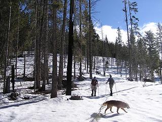 Through the clear cut toward the ridge 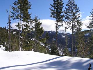 Lookout is a long, long way away 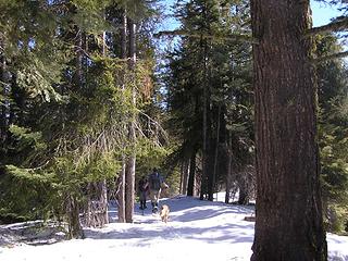 Entering forested part of the ridge 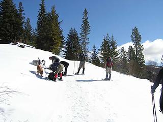 Snack break on ridge 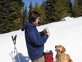 Jack's new best friend 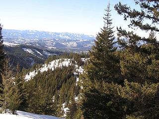 Looking back to the ridge where we took a snack break 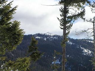 Still a long way away! 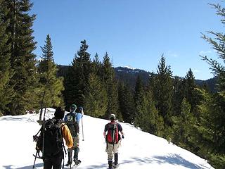 Jim describing the way to the lookout way in the distance 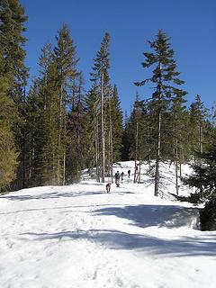 Heading up ridge 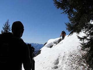 K coming down a tricky descent along the ridge 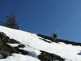 Jim K heading up the ridge against a cloudless sky 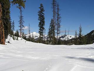 Miller Peak in the distance  We were able to look across and see Tronsen Ridge where we were last weekend. We were able to look across and see Tronsen Ridge where we were last weekend.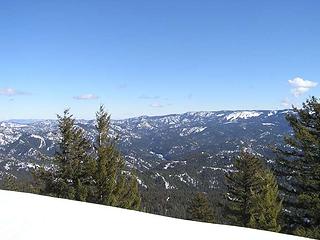 Looking East/Northeast across Blewett Pass and to Tronsen Ridge 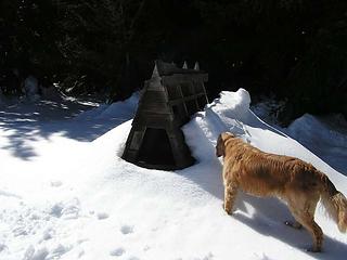 Hmm - what's this? 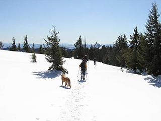 Ridge walk heading towards lookout 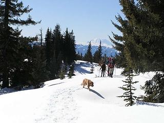 The big "R" in the distance 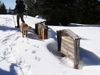 Signs for what? 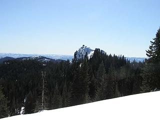 Destination still in the distance 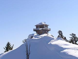 K on the way to our destination 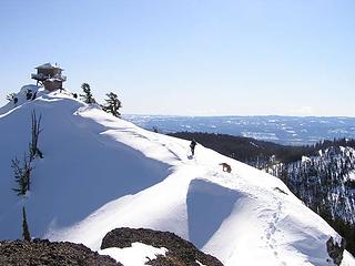 Gusto heading for the lunch break! 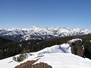 Looking out along the ridge that leads to the lookout - Stuart/Stuart range and Enchantments in the distance 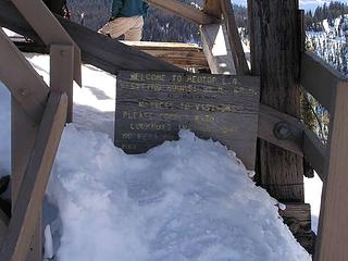 Lookout sign at the base of the lookout 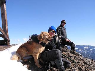 On top! 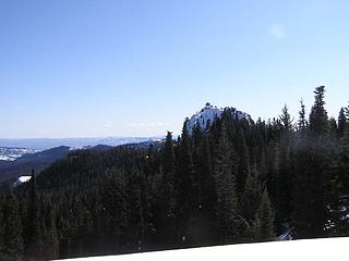 Red Top as an Island in the sky 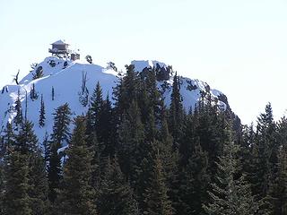 Our route is to the right of the rock block on the ridge - a little notch that looks impossible 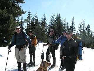 The "crew" on the ridge as we head down 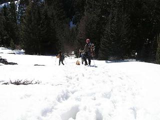 B & K with Gusto heading down slope in soft snow 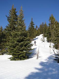 Jack coming off of ridge 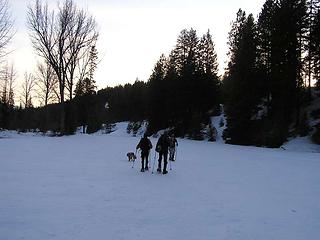 Heading out at sun down on Indian Creek Road   Great group of folks to spend a full day in the Teanaways! Great group of folks to spend a full day in the Teanaways!  (sorry you didn't get to do Teanaway Butte too, Barry, you were with a group of slow-pokes! (sorry you didn't get to do Teanaway Butte too, Barry, you were with a group of slow-pokes!   ) )
Four-paw buddy lets me tag along!
Four-paw buddy lets me tag along!
|
| Back to top |
  
|
|
Bryan K
Shameless Peakbagger

Joined: 29 Sep 2005
Posts: 5129 | TRs | Pics
Location: Alaska |
|
Bryan K
Shameless Peakbagger
|
 Sun Mar 09, 2008 12:28 am |
|
|
|
| Back to top |
|
|
Type E
Member

Joined: 19 Aug 2006
Posts: 1381 | TRs | Pics
|
|
Type E
Member
|
Sun Mar 09, 2008 12:55 am |
|
|
Good work, I will be able to get a view of your route Monday weather permitting of course!
|
| Back to top |
|
|
Matt
Tea, Earl Grey, Hot

Joined: 30 Jan 2007
Posts: 4307 | TRs | Pics
Location: Shoreline |
|
Matt
Tea, Earl Grey, Hot
|
Sun Mar 09, 2008 3:13 am |
|
|
Looks like you all had a great time.
It does look much warmer. For some reason, that valley was an icebox when we started.
FWIW, my 2006 trip report actually isn't on nwhikers, but it's here.
BTW, some people said they haven't been able to access the old reports from my site. If you run into that, let me know.
As beacons mountains burned at evening. J.R.R. Tolkien
As beacons mountains burned at evening. J.R.R. Tolkien
|
| Back to top |
|
|
Sadie's Driver
Sadie's Driver
Joined: 24 Apr 2006
Posts: 1763 | TRs | Pics
Location: Welcome Pass |
| Type E wrote: | | Good work, I will be able to get a view of your route Monday weather permitting of course! |
T/E - Good luck! We found that often our track wasn't visible because the warmth/sun melted out the steps. Be sure and check out Matt's map (he put a link in this report) and also David's (Opus) addition. It's a great trip - hope the weather cooperates. s.d.
Four-paw buddy lets me tag along!
Four-paw buddy lets me tag along!
|
| Back to top |
|
|
Middle E
no more moustache

Joined: 10 Feb 2008
Posts: 432 | TRs | Pics
Location: Seattle, WA |
|
Middle E
no more moustache
|
Sun Mar 09, 2008 8:43 am |
|
|
Yes, my first trip to the Teanaway's, summer or winter, and the spectacular weather was just as advertised. I have this rule that the hiking time has to be longer than driving time...and considering the 9 hours of hiking and our, um, brisk pace on the road there was no danger of breaking this rule. Are there any hikes shorter than 9 hours?  A few photos to add. A few photos to add.
 Teanaway ridge 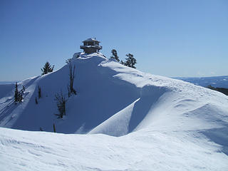 Final ridge 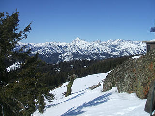 Mt. Stuart 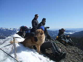 Driver and drivee on summit  Jim descending the chute
pithy yet insightful signature
pithy yet insightful signature
|
| Back to top |
|
|
Opus
Wannabe

Joined: 04 Mar 2006
Posts: 3700 | TRs | Pics
Location: The big rock candy mountain |
|
Opus
Wannabe
|
Sun Mar 09, 2008 10:20 am |
|
|
What a great trip! Fantastic weather, fun travel, some spicy spots getting on the lookout ridge. A long day but well worth it. After editing out the extraneous blips in my GPS track it turns out we only did 12.8 miles with 4125 ft total gain. Guess we should have added in a few extra little ridge bumps along the way!  Full trip photos here. I'll add photo captions soon.
EDIT: Some panoramas!
Full trip photos here. I'll add photo captions soon.
EDIT: Some panoramas!
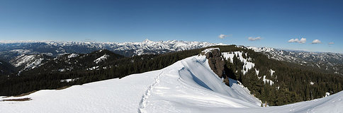 Ridgetop view  Stuart range
|
| Back to top |
|
|
mtnrider
Member

Joined: 29 Jan 2002
Posts: 122 | TRs | Pics
Location: Arlington |
|
mtnrider
Member
|
Sun Mar 09, 2008 10:22 am |
|
|
Thanks for bringing back memories of a great trip. When we did this trip back in the 70's & 80's on snowshoes or skiis we usually went in from the east. The Blue Creek Road can sometimes be driven to the junction at 3600' but if not we did it on foot. From that junction we more or less followed the route of the old Blue Creek Trail to near the lookout and then ascended to the top by the route you described.
The first time we did that trip we ran into lots of snowmobiles on the Blue Creek Rd. When asked how many were in their group they answered about three hundred or so! Seems there was a snowmobile convention in Cle Elum and they all were headed to the Mineral Springs Resort for lunch.
We had to get off that road so we headed up the old Blue Creek Trail. It's a good route.
Thanks for the great trip report. I'm glad you experience the marvelous Teanaway weather.
|
| Back to top |
|
|
yukon222
Member

Joined: 12 Mar 2007
Posts: 1893 | TRs | Pics
|
|
yukon222
Member
|
Sun Mar 09, 2008 10:30 am |
|
|
| Opus wrote: | | What a great trip!
|
Glad you guys had such wonderful weather although the Teanaway seldom disappoints! Opus, love this shot. Heading into the light, a little bit of unknown as you can't see what they are moving towards. Just great!
|
| Back to top |
|
|
Sadie's Driver
Sadie's Driver
Joined: 24 Apr 2006
Posts: 1763 | TRs | Pics
Location: Welcome Pass |
Four-paw buddy lets me tag along!
|
| Back to top |
|
|
TrailPair
Member

Joined: 17 Apr 2005
Posts: 1699 | TRs | Pics
|
With all of the great photos already posted we don't have much to add.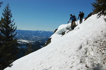 Jim K and Driver 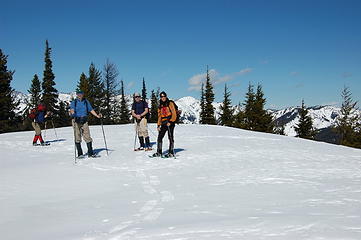 Jack, Jim K, Barry and K 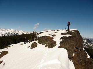 Bob on Red Top. Opus below. 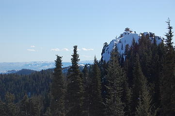 Another view of Look Out. 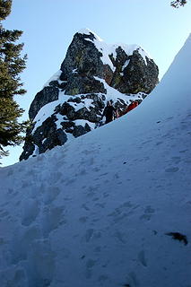 Opus and Jack descending chute. 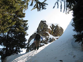 Jim K approaching chute.
This thing called work is interfering with my play
This thing called work is interfering with my play
|
| Back to top |
|
|
Curtissimo
Member

Joined: 05 Sep 2007
Posts: 295 | TRs | Pics
Location: Mexico Lindo y Querido si Muero Lejos de Ti |
outstanding trip! now i know where we should have gone this weekend but didn't!
agree with yukon on that shot being favorite.
|
| Back to top |
|
|
Magellan
Brutally Handsome

Joined: 26 Jul 2006
Posts: 13116 | TRs | Pics
Location: Inexorable descent |
|
Magellan
Brutally Handsome
|
Sun Mar 09, 2008 3:23 pm |
|
|
Really great trip you guys. The picture of Jim K pointing at something has become a tradition. Teanaway 
|
| Back to top |
|
|
Yet
Member

Joined: 23 Apr 2005
Posts: 2634 | TRs | Pics
Location: Happily Ever After |
|
Yet
Member
|
Sun Mar 09, 2008 3:29 pm |
|
|
SD and gang -
You all have such fantastic adventures!
I'm only just a little bit jealous.
|
| Back to top |
|
|
More Cowbell
Warrior Princess

Joined: 01 Jul 2006
Posts: 5657 | TRs | Pics
Location: Alive on Earth |
I love the one pic without the snow heading up the ridge. I can just smell those morel spores getting ready for hunting season (shroom hunting that is).
If you want to forget all your other troubles, wear too tight shoes. - Unknown
If you want to forget all your other troubles, wear too tight shoes. - Unknown
|
| Back to top |
|
|
|
|
You cannot post new topics in this forum
You cannot reply to topics in this forum
You cannot edit your posts in this forum
You cannot delete your posts in this forum
You cannot vote in polls in this forum
|
Disclosure: As an Amazon Associate NWHikers.net earns from qualifying purchases when you use our link(s). |


 Nice to see what the lookout looks like all boarded up. Though I must say that brown shutters are ugly, they should be white.
Glad you guys made the summit
Nice to see what the lookout looks like all boarded up. Though I must say that brown shutters are ugly, they should be white.
Glad you guys made the summit 


 Excuse me? Are you saying 1 1/2 hours of driving time was fast?
  Honest, there just wasn't any traffic!!!


