| Previous :: Next Topic |
| Author |
Message |
Ancient Ambler
Member


Joined: 15 May 2007
Posts: 1092 | TRs | Pics
Location: Bainbridge Island |
Lucked into a clear day and took off by snowshoe toward 6247 ft. Eagle Point, about 5 miles east of Hurricane Ridge. Snotel reports from Waterhole about 4 miles out on the route indicated very little precipitation in the past week, and consistent with that we found only 3 to 5 inches of loose snow on top of a very solid base. Local avalanche danger looked to be rather low, so we took off toward Eagle Point from the departure point about a half mile downhill from the Hurricane Ridge parking lot.
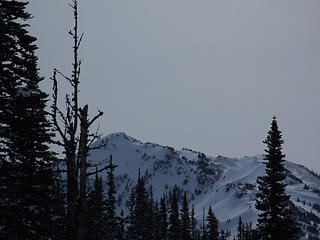 Eagle Point from Obstruction Point Road 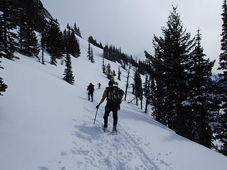 Route past Steeple Rock 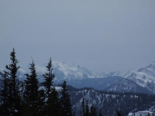 Mt. Delabarre 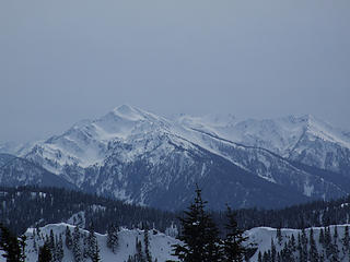 Mts. Dana, Christie, Wilder 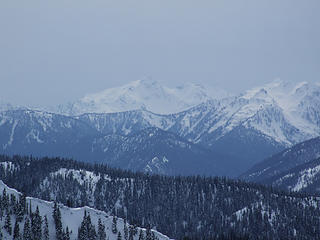 Mt. Seattle 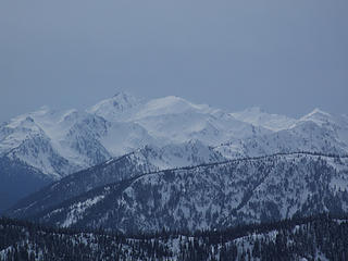 Mts. Meany, Queets 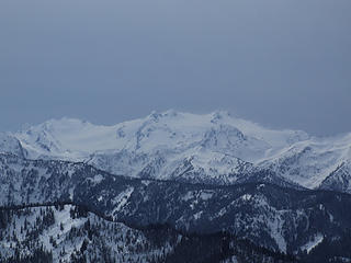 Mt. Olympus 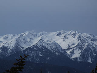 Mts. Carrie, Fairchild 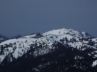 Hurricane Ridge 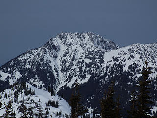 Mt. Angeles
|
| Back to top |
  
|
|
RonL
Member

Joined: 22 Nov 2006
Posts: 131 | TRs | Pics
|
|
RonL
Member
|
 Sun Mar 23, 2008 1:55 pm |
|
|
Cool, I was up there Saturday as well. I just skied around the Hurricane Hill area. Is that parking area on the right hand side of the road before you get to the top where the route for waterhole starts? Or did you park up top and walk back down to head out there? I would like to explore that area on my next trip to the Penninsula.
|
| Back to top |
|
|
goats gone wild
Mr. Goat

Joined: 19 Aug 2007
Posts: 2524 | TRs | Pics
Location: Vampireville |
.....leaving me wanting to return over and over in what ever capacity that may be, even if one day my knees are too old and I can only see the mountains from my porch.
Jason Hummel
|
| Back to top |
|
|
Ancient Ambler
Member
Joined: 15 May 2007
Posts: 1092 | TRs | Pics
Location: Bainbridge Island |
RonL,
Yes, parking for the snow route out the Obstruction Pt. Road is on the right side of the highway, just downhill from the last curve before you get to the Ridge parking lot. Just cross to the east side of the highway, climb the snowbank, and head uphill to the highway curve, at which point you will find an open snowfield which you descend southeasterly to intercept the path of the Obstruction Point Road heading east through the trees. The actual starting point for the Obstruction Point road is at the east end of the Ridge parking lot, but the first quarter mile or so traverses extremely steep sidehill that is not safe when covered with snow.
|
| Back to top |
|
|
RonL
Member
Joined: 22 Nov 2006
Posts: 131 | TRs | Pics
|
|
RonL
Member
|
Sun Mar 23, 2008 3:00 pm |
|
|
|
| Back to top |
|
|
EastKing
Surfing and Hiking

Joined: 28 Mar 2007
Posts: 2082 | TRs | Pics
Location: 77 miles from Seattle! |
|
EastKing
Surfing and Hiking
|
Sun Mar 23, 2008 3:05 pm |
|
|
Great trip report! I know about cramps getting in the way (bananas, salty snacks and lots of water is now my diet for trips). Still you got some great picks, Thank you for sharing.  I hope soon I can get out in the Olympics!
YouTube | SummitPost
Saw the depths of despair. Now I am salvaging what time I have left on Earth.
YouTube | SummitPost
Saw the depths of despair. Now I am salvaging what time I have left on Earth.
|
| Back to top |
|
|
raising3hikers
Member
Joined: 21 Sep 2007
Posts: 2344 | TRs | Pics
Location: Edmonds, Wa |
Nice pics, I 've never been ther but it's now on my list 
|
| Back to top |
|
|
|
|


 can help reduce/eliminate muscle cramping, but you probably already know that. Anyway, I hope this hiking season brings you lots of opportunity to be active as can be.....with no more quad cramping.