| Previous :: Next Topic |
| Author |
Message |
Bloated Chipmunk
Cock Rock Searcher


Joined: 29 Jan 2007
Posts: 2993 | TRs | Pics
Location: Margaritaville |
A bit late on the TR, yes. But like the Easter bunny delivering chocolate, better late than never, right? Spring has sprung so distraction comes easily, I suppose...  However, winter was still evident in the Merritt Lk. area. Prior to this hike, my research of TRs resulted in summer-only excursions. Seems as though no one goes to this place in the winter, for what reason remains a mystery. Everyone must get as far east as the ever-popular Smithbrook Rd. and associated trails that the nearby Merritt gets overlooked. Because it seemed this area was seldom visited via snowshoe, it made it all the more tantalizing for me to visit.
  Todd & I departed from Everett around 7:30 AM. Sailing was smooth along hwy. 2 through the various small towns leading up to the pass. We were greeted by a few snow flurries at the ski slopes, as well as the brief congestion caused by pedestrians making a run for it across the hwy. from one parking lot to the other. Once beyond the crest sunshine broke through the clouds and stuck with us for the remainder of the trip. Spotting the pullout for the forest rd. was tricky, however thankfully we saw the sign for Merritt Lk. just in time and as we slowed to turn in, a driver coming up behind honked for no apparent reason. Either it was someone we knew (a fellow hiker, perhaps?) or they were just an idiot. Since I didn't recognize the car, I'm guessing the latter.
  The parking is slim--room for only a few vehicles--but safe nevertheless. No parking pass needed here since it's just the shoulder of the rd., but we sported one anyway. After a few minutes of donning the gaiters & such, we started up the rd. A few steps convinced us to strap on the snowshoes (snow was compact/solid in some areas but not in others) and we were off. The forest rd. is 1.6 mi. to the trailhead, an easy incline with the option of cutting the switchbacks in a couple locations. Before long we reached the empty snow-locked summer parking lot and the trail register. Curious to find out when the last visitor came, we checked the logs. Two dudes at the end of November were the last ones. Wow, 4 mos. of winter had hit this region in the meantime, so we knew what was in store for us on this day--mile upon mile of breaking trail, w/multiple stops for GPS consultation.
  For the 1st mi. or so of trail, route finding was relatively easy as enough snow had receded to reveal a slight depression where we guessed the trail must be and a check of a map and GPS confirmed this. The grade was pretty easy at 1st & sinking was practically nonexistent so we made excellent time. Soon we came upon some boulders w/cool icicles & stopped for a couple photos before traversing below and around to the left/south of the big rocks. We temporarily lost the trail but seemed to pick it up again above the boulders. From here the route turned pretty steep as we aimed toward the ridgeline and had to negotiate more rocks. The snow was deeper and sliding was easier so our pace was consequently slowed. The trail was no longer evident so we relied more heavily on the map & GPS at this point. The summer route steadily switchbacks up the slope, attaining the ridge somewhere around the 4,200' level. For the most part we followed this, though most likely with fewer switchbacks & more dicey sections.
  After a particularly hairy bit, the incline eased & we approached a false ridge line & angled our way NW to the true ridge, topping out at the spine in roughly the same area as the summer trail. From here the ridge walk was pretty easy at 1st but soon became narrower & steeper. The map showed the summer trail crossing over the ridge line & traversing slightly below it, but finding this crucial junction in the snow would no doubt be challenging, & we weren't even sure that it would be feasible in winter conditions considering it may involve steep sidehilling in which one false move may result in an unintentional glissade of a few hundred feet into Mahor Crk. After a particularly hairy bit, the incline eased & we approached a false ridge line & angled our way NW to the true ridge, topping out at the spine in roughly the same area as the summer trail. From here the ridge walk was pretty easy at 1st but soon became narrower & steeper. The map showed the summer trail crossing over the ridge line & traversing slightly below it, but finding this crucial junction in the snow would no doubt be challenging, & we weren't even sure that it would be feasible in winter conditions considering it may involve steep sidehilling in which one false move may result in an unintentional glissade of a few hundred feet into Mahor Crk.  We did eventually reach an area of the ridge where a crossover looked doable & decided to go for it. However, after 50' or so it became clear that the sidehill angle was sharpening & that to continue to traverse would be mighty risky. Instead, we headed back to our crossover point & continued on up the spine of the ridge, avoiding a cornice on the north side. We snow scrambled up a steep bit (not before Todd exclaimed "You're not seriously going up that, are you?!" to which I replied "It doesn't look too bad.") After ascending a couple hundred feet in short (relatively) order, the spine eased greatly & we spotted what appeared to be a valley down the ridge to the north (I'm guessing we were near the junction w/the trail from Crescent Lk.). Also through the trees, but to the south, was a broad flat sunny promontory which begged exploration but we resisted temptation for the time being. We still held out hope of finding an easy way down/across the slope to the north in order to hit Merritt Lk. but w/every inspection, we encountered what was essentially a cliff. Another check of the GPS revealed that now we were actually above the lk. in elevation, so we decided to head to that sunny promontory we'd seen earlier for lunch. We did eventually reach an area of the ridge where a crossover looked doable & decided to go for it. However, after 50' or so it became clear that the sidehill angle was sharpening & that to continue to traverse would be mighty risky. Instead, we headed back to our crossover point & continued on up the spine of the ridge, avoiding a cornice on the north side. We snow scrambled up a steep bit (not before Todd exclaimed "You're not seriously going up that, are you?!" to which I replied "It doesn't look too bad.") After ascending a couple hundred feet in short (relatively) order, the spine eased greatly & we spotted what appeared to be a valley down the ridge to the north (I'm guessing we were near the junction w/the trail from Crescent Lk.). Also through the trees, but to the south, was a broad flat sunny promontory which begged exploration but we resisted temptation for the time being. We still held out hope of finding an easy way down/across the slope to the north in order to hit Merritt Lk. but w/every inspection, we encountered what was essentially a cliff. Another check of the GPS revealed that now we were actually above the lk. in elevation, so we decided to head to that sunny promontory we'd seen earlier for lunch.  What a view!
  Well, for about 5 mins. The wind picked up & we headed back into the trees to eat. Clouds thinly veiled the sun now, but we were thankful for our brief view of snowy peaks to the east & south. Time was running short as we were scheduled for dinner at Todd's parents' house that evening. We decided that our sunny overlook was a sort of mini-summit, & perhaps a more appropriate destination for this day than a tree-encircled lk.
After a few more photos, we headed down. We both dreaded the particularly steep sections, even though I usually have an easier time coming down than going up. Todd carefully & expertly kicked in steps, as glissading in most places was not an option unless one had excellent steering ability to avoid smacking into the densely placed trees. Well, for about 5 mins. The wind picked up & we headed back into the trees to eat. Clouds thinly veiled the sun now, but we were thankful for our brief view of snowy peaks to the east & south. Time was running short as we were scheduled for dinner at Todd's parents' house that evening. We decided that our sunny overlook was a sort of mini-summit, & perhaps a more appropriate destination for this day than a tree-encircled lk.
After a few more photos, we headed down. We both dreaded the particularly steep sections, even though I usually have an easier time coming down than going up. Todd carefully & expertly kicked in steps, as glissading in most places was not an option unless one had excellent steering ability to avoid smacking into the densely placed trees.  After some time we were through the steepest part of the ridge spine & our knees thanked us for the respite. We walked where we could, & kicked in where we had to. Soon we were at the point at which we had initially gained the true ridge, and turned in a more southernly direction to follow our tracks. Here, I managed a couple short glissades (later I noticed a rip in the @$$ of my rain pants--oops). Then back to the boulders, where we discovered that we had to have been slightly insane to pick the exact route we did. Nevertheless, we got down after some falling & cursing, After some time we were through the steepest part of the ridge spine & our knees thanked us for the respite. We walked where we could, & kicked in where we had to. Soon we were at the point at which we had initially gained the true ridge, and turned in a more southernly direction to follow our tracks. Here, I managed a couple short glissades (later I noticed a rip in the @$$ of my rain pants--oops). Then back to the boulders, where we discovered that we had to have been slightly insane to pick the exact route we did. Nevertheless, we got down after some falling & cursing,  & it was smooth sailing at this point. That is until, inexplicably, we lost our tracks from the morning & actually overshot the trailhead by being too far north. After some walking around in circles a bit & determining that we needed to head SE, I spotted the TH sign. At last!--An easy rd. walk now...no more need to have one's full undivided attention placed at the feet. The rd. back to the car was uneventful minus postholing once by a fallen tree & the observation of fresh cc skier tracks--the 1st sign of recent human activity all day. We reached the car near sunset & Todd phoned his parents, who were ready to eat but would keep the food warm for us. We headed back into town, luckily missing the usual hwy. 2 traffic. We spiffed up in Everett & then headed to Edmonds where delicious home-cooked Indian leftovers and wine awaited. & it was smooth sailing at this point. That is until, inexplicably, we lost our tracks from the morning & actually overshot the trailhead by being too far north. After some walking around in circles a bit & determining that we needed to head SE, I spotted the TH sign. At last!--An easy rd. walk now...no more need to have one's full undivided attention placed at the feet. The rd. back to the car was uneventful minus postholing once by a fallen tree & the observation of fresh cc skier tracks--the 1st sign of recent human activity all day. We reached the car near sunset & Todd phoned his parents, who were ready to eat but would keep the food warm for us. We headed back into town, luckily missing the usual hwy. 2 traffic. We spiffed up in Everett & then headed to Edmonds where delicious home-cooked Indian leftovers and wine awaited. 
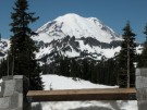
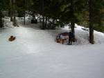 Merritt Lk. TH 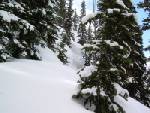 Cornice 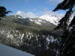 View north from ridge 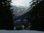 View east from ridge 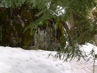 Icicles 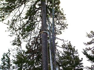 Funky trees 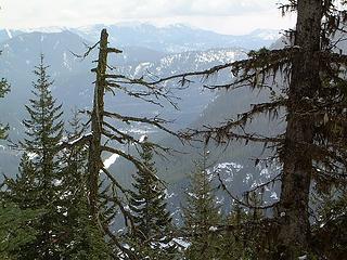 View to the east
Home is where the hiking is.
"Peaks that have come and gone four times should halt a man in his steps." -- William O. Douglas
A balanced diet is a margarita in each hand.
Home is where the hiking is.
"Peaks that have come and gone four times should halt a man in his steps." -- William O. Douglas
A balanced diet is a margarita in each hand.
|
| Back to top |
  
|
|
wildernessed
viewbagger

Joined: 31 Oct 2004
Posts: 9275 | TRs | Pics
Location: Wenatchee |
 I often thought that would be a good winter trip, even an alternative way to alpine lookout or thruhike to Round and out.Can't wait to see your pics. I often thought that would be a good winter trip, even an alternative way to alpine lookout or thruhike to Round and out.Can't wait to see your pics. 
Living in the Anthropocene
Living in the Anthropocene
|
| Back to top |
|
|
Bloated Chipmunk
Cock Rock Searcher
Joined: 29 Jan 2007
Posts: 2993 | TRs | Pics
Location: Margaritaville |
Yeah, I should have a link to the pics soon...but don't get too excited though b/c it will only be about 4 pictures... 
Home is where the hiking is.
"Peaks that have come and gone four times should halt a man in his steps." -- William O. Douglas
A balanced diet is a margarita in each hand.
Home is where the hiking is.
"Peaks that have come and gone four times should halt a man in his steps." -- William O. Douglas
A balanced diet is a margarita in each hand.
|
| Back to top |
|
|
MLHSN
What goes here?????

Joined: 09 Sep 2007
Posts: 1069 | TRs | Pics
Location: Wenatchee |
|
MLHSN
What goes here?????
|
 Tue Mar 25, 2008 8:43 pm |
|
|
|
| Back to top |
|
|
wildernessed
viewbagger
Joined: 31 Oct 2004
Posts: 9275 | TRs | Pics
Location: Wenatchee |
The whole route looks nice, with the exception of the red area on the map W. of Alpine Lookout. That section, right now, does not look "user friendly".
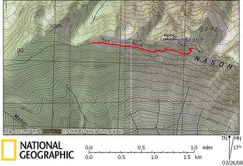 Nason Ridge W of Alpine Lookout
Living in the Anthropocene
Living in the Anthropocene
|
| Back to top |
|
|
Bloated Chipmunk
Cock Rock Searcher
Joined: 29 Jan 2007
Posts: 2993 | TRs | Pics
Location: Margaritaville |
| wildernessed wrote: | The whole route looks nice, with the exception of the red area on the map W. of Alpine Lookout. That section, right now, does not look "user friendly".
Nason Ridge W of Alpine Lookout |
Yeah, that section looks pretty hairy! One step away from never-never land. Good luck you two!
Home is where the hiking is.
"Peaks that have come and gone four times should halt a man in his steps." -- William O. Douglas
A balanced diet is a margarita in each hand.
Home is where the hiking is.
"Peaks that have come and gone four times should halt a man in his steps." -- William O. Douglas
A balanced diet is a margarita in each hand.
|
| Back to top |
|
|
Schmidt Alti-Dude
4th class poster

Joined: 06 Jul 2007
Posts: 1361 | TRs | Pics
Location: Looking for Adventure 201! |
Thanks for the TR, BC. I think I speak for a lot of "lake baggers" when I state that the reason nobody goes there in the winter is there is nothing to see at the lake. Where's the pics?
Anything stated by me in no way reflects the attitudes or opinions of my wife
Anything stated by me in no way reflects the attitudes or opinions of my wife
|
| Back to top |
|
|
MLHSN
What goes here?????
Joined: 09 Sep 2007
Posts: 1069 | TRs | Pics
Location: Wenatchee |
|
MLHSN
What goes here?????
|
Wed Mar 26, 2008 2:35 pm |
|
|
| wildernessed wrote: | The whole route looks nice, with the exception of the red area on the map W. of Alpine Lookout. That section, right now, does not look "user friendly".
Nason Ridge W of Alpine Lookout |
Ya, nevermind about that trip now. I got snowed on at 1100' today. That makes that section really not so "user friendly" now.
|
| Back to top |
|
|
ree
Member

Joined: 29 Jun 2004
Posts: 4399 | TRs | Pics
|
|
ree
Member
|
Fri Mar 28, 2008 10:35 am |
|
|
That link to the pictures didn't work for me.  It said
 | Quote: | | That's the end of Todd's slideshow! What's Next? |
|
| Back to top |
|
|
DRSpalding
Probably riding MTB
Joined: 13 Mar 2008
Posts: 458 | TRs | Pics
Location: Redmond, WA |
|
DRSpalding
Probably riding MTB
|
Fri Mar 28, 2008 12:44 pm |
|
|
| Bloated Chipmunk wrote: | | Here are the pics, @ long last. Sorry for the delay: Link |
Change the "SlideshowEnd" to "Slideshow" and it worked for me. I reposted the link i used.
|
| Back to top |
|
|
Bloated Chipmunk
Cock Rock Searcher
Joined: 29 Jan 2007
Posts: 2993 | TRs | Pics
Location: Margaritaville |
Weird, sorry about that. After I posted that link, I clicked on it to make sure it worked & it did, w/o any alteration. Not sure why it didn't work for you.  But glad you got to see 'em eventually! But glad you got to see 'em eventually!
Home is where the hiking is.
"Peaks that have come and gone four times should halt a man in his steps." -- William O. Douglas
A balanced diet is a margarita in each hand.
Home is where the hiking is.
"Peaks that have come and gone four times should halt a man in his steps." -- William O. Douglas
A balanced diet is a margarita in each hand.
|
| Back to top |
|
|
CC
cascade curmudgeon

Joined: 13 Sep 2006
Posts: 647 | TRs | Pics
|
|
CC
cascade curmudgeon
|
Tue Apr 01, 2008 7:33 pm |
|
|
| Quote: | | Prior to this hike, my research of TRs resulted in summer-only excursions. Seems as though no one goes to this place in the winter, for what reason remains a mystery. |
Actually it's a fairly popular winter trip, e.g., it's listed as a mountaineer's snowshoe this sunday.
First your legs go, then you lose your reflexes, then you lose your friends. Willy Pep
First your legs go, then you lose your reflexes, then you lose your friends. Willy Pep
|
| Back to top |
|
|
Bloated Chipmunk
Cock Rock Searcher
Joined: 29 Jan 2007
Posts: 2993 | TRs | Pics
Location: Margaritaville |
| CC wrote: | | Actually it's a fairly popular winter trip, e.g., it's listed as a mountaineer's snowshoe this sunday. |
Hmm, interesting. I guess we just happened to be there on one of the unpopular days. I prefer it that way though.
Home is where the hiking is.
"Peaks that have come and gone four times should halt a man in his steps." -- William O. Douglas
A balanced diet is a margarita in each hand.
Home is where the hiking is.
"Peaks that have come and gone four times should halt a man in his steps." -- William O. Douglas
A balanced diet is a margarita in each hand.
|
| Back to top |
|
|
|
|
You cannot post new topics in this forum
You cannot reply to topics in this forum
You cannot edit your posts in this forum
You cannot delete your posts in this forum
You cannot vote in polls in this forum
|
Disclosure: As an Amazon Associate NWHikers.net earns from qualifying purchases when you use our link(s). |


