| Previous :: Next Topic |
| Author |
Message |
kitya
Fortune Cookie


Joined: 15 Mar 2010
Posts: 842 | TRs | Pics
Location: Duvall, WA |
|
kitya
Fortune Cookie
|
 Sun Mar 31, 2019 8:38 am |
|
|
I say finally because it feels like I wanted to checkout Low Mountain forever and it took me 3 weeks to finally get there. 2 weeks ago as I was driving to the trailhead, I had to instead do an emergency detour to wildlife rahabilitation center to rescue an injured muskrat. A week ago I had to detour and help find a lost dog. Finally this week I made it to the trailhead, even though I accidentally forgot my license at home.
Road NF-5800 is still blocked by 'road closed' signs right at the exit 47, even though it is perfectly bare (plowed) almost all the way to Denny creek campground, where snow starts. I saw a few people ignoring road closed sign and driving anyway, including one SUV getting stuck. There is also a shorter way to walk back down from Summit West, but given a choice of more driving vs. an extra mile of walking, I think choice is obvious - walking 3 miles on NF-5800 was actually not bad at all. It is a pretty road and there are a few big trees around it, including at least one really big old growth douglas fir.
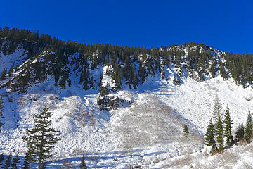
Once at Melakwa lake trailhead, there is an established boot path in the snow, so navigation and postholing are not a problem. Soon after crossing the Denny creek waterslide, at the first hairpin turn (2850ft elevation) I put on snowshoes and left the trail and started traversing up on the open slope. Despite being open and a bit steep, this slope doesn't actually look like it has a lot of avy potential, in fact this is the only slope where I didn't see any evidence of past avalanche activity and now avalanche danger is really low anyway. However different problem exist. By now at such low elevation, it is just a thin layer of snow hiding giant boulders and creeks under it, ready to eat you alive. I fell through a few times, up to my neck. Even Cookie got scared. It is freaking hot and snow is really soft and slushy. We tracked back and tried going near the trees, where snow is slightly more strong in the shade.
It was a depressing reminder that winter seems to be already over. Seems like summer is coming sooner and sooner every year.
We slowly made our way up, trying to not fall through into under snow creeks and waterfalls. Eventually we got to the higher scree basin, where snow finally got a little bit deeper and grade gentler. It is surprisingly beautiful in this second basin and there are good views to Granite Mountain.
After gaining the ridge it is a pleasant walk almost all the way to the summit of Low, where last few hundred feet the ridge becomes scary narrow. I had to take out my ice axe and get off snowshoes. With very soft snow it didn't feel too safe and so I left Cookie waiting for me behind on one of the bumps just before the summit, while I got to the true summit and back.
The views from Low are better than expected and the route is more fun than expected. To the south Mount Rainier and Granite Mountain. I could even make out two hikers reaching Granite Mountain Lookout. To the north Kaleetan peak is right there. Upper and lower Tuscohatchie lakes between Granite and West Granite look already blue with melting snow.
On the way down I decided to take a different route and basically snowshoed straight down from Low to Snowshoe Falls. That slope is actually much nicer than the way up, with more big trees and gentler grade almost all the way, except for the very last section near the bottom, where it gets a bit too steep/cliffy. But best of all this route avoids I-90 noise. keekwulee falls are pretty too.
On the way back we saw a few people walking the road. Sadly road and section of the trail to the waterslide now approach Franklin falls levels of trashiness and I packed out a bunch of beer bottles, dozen of dog poop bags and various other trash.
https://connect.garmin.com/modern/activity/3511147898
 Now I Fly Now I Fly
Now I Fly |
| Back to top |
  
|
|
RichP
Member

Joined: 13 Jul 2006
Posts: 5634 | TRs | Pics
Location: here |
|
RichP
Member
|
Sun Mar 31, 2019 9:06 am |
|
|
Great views of some local favorites there. 
|
| Back to top |
|
|
BarbE
Member

Joined: 28 Jul 2006
Posts: 1153 | TRs | Pics
|
|
BarbE
Member
|
Mon Apr 01, 2019 9:25 am |
|
|
Looking across Tuscohatchie Lake on Saturday, early afternoon from Granite lookout.
Low Mountain I assume is directly above the lake on the right.
|
| Back to top |
|
|
puzzlr
Mid Fork Rocks

Joined: 13 Feb 2007
Posts: 7220 | TRs | Pics
Location: Stuck in the middle |
|
puzzlr
Mid Fork Rocks
|
Mon Apr 01, 2019 10:31 am |
|
|
That's really interesting to hear a route down the center of the east face works. I climbed it from Hemlock Pass but that had quite a bit of brush and trees to push through. I was eyeing that area you came down because it looked like it might work but I was concerned about the cliff band.
 View across valley to Low Mountain. Summit is just peeking out
|
| Back to top |
|
|
RichP
Member
Joined: 13 Jul 2006
Posts: 5634 | TRs | Pics
Location: here |
|
RichP
Member
|
Mon Apr 01, 2019 11:06 am |
|
|
|
| Back to top |
|
|
kitya
Fortune Cookie
Joined: 15 Mar 2010
Posts: 842 | TRs | Pics
Location: Duvall, WA |
|
kitya
Fortune Cookie
|
Mon Apr 01, 2019 12:50 pm |
|
|
| puzzlr wrote: | | That's really interesting to hear a route down the center of the east face works. I climbed it from Hemlock Pass but that had quite a bit of brush and trees to push through. I was eyeing that area you came down because it looked like it might work but I was concerned about the cliff band. |
There definitely is the cliff band down and I was lucky I could find some way around them. Even so it had some steep parts, but it worked. I was worried I would have to go all the way back up, if it didn't 
|
| Back to top |
|
|
kitya
Fortune Cookie
Joined: 15 Mar 2010
Posts: 842 | TRs | Pics
Location: Duvall, WA |
|
kitya
Fortune Cookie
|
Mon Apr 01, 2019 12:51 pm |
|
|
That seems like a cool route! But Granite mountain can be scary in winter.
|
| Back to top |
|
|
kitya
Fortune Cookie
Joined: 15 Mar 2010
Posts: 842 | TRs | Pics
Location: Duvall, WA |
|
kitya
Fortune Cookie
|
Mon Apr 01, 2019 12:51 pm |
|
|
| BarbE wrote: | | Looking across Tuscohatchie Lake on Saturday, early afternoon from Granite lookout.
Low Mountain I assume is directly above the lake on the right. |
Great view! Thank you!
|
| Back to top |
|
|
Type E
Member

Joined: 19 Aug 2006
Posts: 1381 | TRs | Pics
|
|
Type E
Member
|
Mon Apr 01, 2019 3:33 pm |
|
|
I did Low leaving the trail just after the flat section before recrossing the creek and had no problems
|
| Back to top |
|
|
|
|


