| Previous :: Next Topic |
| Author |
Message |
JoeB
Member


Joined: 30 May 2007
Posts: 9 | TRs | Pics
|
|
JoeB
Member
|
 Mon Jun 02, 2008 9:49 am |
|
|
Bruce, Eric, Oliver & I hiked to the top of Snoqualmie Mountain on Saturday. Consolidated snow covered the trail. We brought ice axes and recommend them. Snow varied from soft and slippery to hard and slippery.
Here's the view from the top.
Full Size Panorama
There is an impressive view from the Alpental parking lot of avalanche destruction.
|
| Back to top |
  
|
|
tigermn
Member

Joined: 10 Jul 2007
Posts: 9242 | TRs | Pics
Location: There... |
|
tigermn
Member
|
Mon Jun 02, 2008 9:57 am |
|
|
Did you also use crampons/other traction devices? It sounds like something might be advisable.
|
| Back to top |
|
|
JoeB
Member
Joined: 30 May 2007
Posts: 9 | TRs | Pics
|
|
JoeB
Member
|
Mon Jun 02, 2008 10:02 am |
|
|
No crampons or other traction. Possibly could have used crampons in the trees where the snow was shaded.
|
| Back to top |
|
|
nwbobcat
Member

Joined: 06 Aug 2007
Posts: 70 | TRs | Pics
Location: Seattle |
|
nwbobcat
Member
|
Tue Jun 03, 2008 2:20 pm |
|
|
What route did you guys take, right up from Apental? How long did it take you guys, was thinking about hitting it up and was wondering how long it takes now.
|
| Back to top |
|
|
Mark Griffith
(Embrace yourself)

Joined: 14 Mar 2005
Posts: 853 | TRs | Pics
Location: Issaquah |
Snoqualmie is one of my favorite hikes along I-90. I need to get up there soon. How was crossing the avalanche field?
|
| Back to top |
|
|
tigermn
Member
Joined: 10 Jul 2007
Posts: 9242 | TRs | Pics
Location: There... |
|
tigermn
Member
|
Tue Jun 03, 2008 4:25 pm |
|
|
In the summer is this truly just a hike or does it involve scrambling that has class designations.
|
| Back to top |
|
|
Mark Griffith
(Embrace yourself)
Joined: 14 Mar 2005
Posts: 853 | TRs | Pics
Location: Issaquah |
|
| Back to top |
|
|
Magellan
Brutally Handsome

Joined: 26 Jul 2006
Posts: 13116 | TRs | Pics
Location: Inexorable descent |
|
Magellan
Brutally Handsome
|
Tue Jun 03, 2008 11:11 pm |
|
|
 A steepish hike. A steepish hike.
|
| Back to top |
|
|
JoeB
Member
Joined: 30 May 2007
Posts: 9 | TRs | Pics
|
|
JoeB
Member
|
Wed Jun 04, 2008 11:47 am |
|
|
I was probably being overly exuberant in describing this as a hike.
It is a little less than two miles, over the ground, each way and the elevation gain from the parking lot is 3122 feet. This is base on a TOPO! analysis of our GPS track, which also shows the average grade as 37%. We were at the top in three hours, this includes a little nourishment break.
This was my first ascent so I cant tell you what it is like at other times of the year. We pretty much went straight up following the boot tracks, which below the waterfall didnt always offer a consensus on the route. To get above the water fall go right then left. The required amount is unknown by me as you can see from the divergence between the ascent and descent at the lower elevations of the track below. Up higher a few feet of a definite trail was exposed on a rocky terrain. It looks like it has switchbacks.
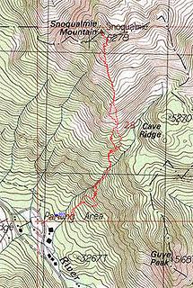 Snoqualmie Mountain Tracks, 2008-May-31 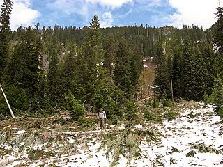 Avalanche Destruction Across from Alpental Parking Lot
|
| Back to top |
|
|
|
|


