| Previous :: Next Topic |
| Author |
Message |
Schmidt Altitude
Whippet Entourage


Joined: 28 Mar 2007
Posts: 803 | TRs | Pics
Location: The Quah |
At 7766' Mount Aix is the highest peak in the William O. Douglas Wilderness. Thus, it drew us in like moths to a flame. Not suprisingly, it was nominated as the goal for Saturday by the NWHikers who had arrived early to the American Ridge Campout.
Sometime during the planning stage the night before, it was determined that we would leave the lodge at the ungodly hour of 9:00AM to drive to the trailhead  . Apparently everyone else doesn't need sleep the way we do so at 8:45 we were woken up to be informed that everyone was waiting on us . Apparently everyone else doesn't need sleep the way we do so at 8:45 we were woken up to be informed that everyone was waiting on us  . The group left at 9:15 consisting of GeoTom and Jasper, GeoDani, puzzler, cartman, dicey, Bryan, wamtngal, Just Todd, and the Schmidt Altitude team (Babe, Rowena, Kiefer, and Dude). We drove to the trailhead with only one small hitch, a 50 foot long section of 10" deep snow across the road in a shaded area. Our Explorer and Tom's truck made it just fine but we had reservations about puzzlr's Forester. He revved the engine and then blasted through with no problems much to our relief . The group left at 9:15 consisting of GeoTom and Jasper, GeoDani, puzzler, cartman, dicey, Bryan, wamtngal, Just Todd, and the Schmidt Altitude team (Babe, Rowena, Kiefer, and Dude). We drove to the trailhead with only one small hitch, a 50 foot long section of 10" deep snow across the road in a shaded area. Our Explorer and Tom's truck made it just fine but we had reservations about puzzlr's Forester. He revved the engine and then blasted through with no problems much to our relief  .
During the drive to the trailhead the following conversation took place in our vehicle: .
During the drive to the trailhead the following conversation took place in our vehicle:- Babe, "I think we forgot our rain gear back at the lodge."
- Dude, "Well, I don't want to go back for it now."
- Babe, "The weather stated a chance of showers."
- Dude, "We'll be fine, look how well they predicted the weather last weekend."
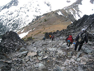
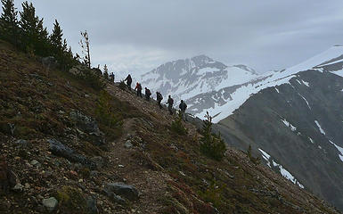
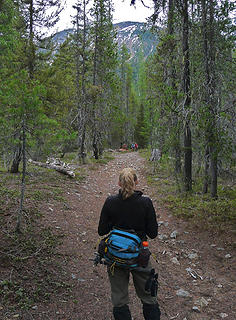
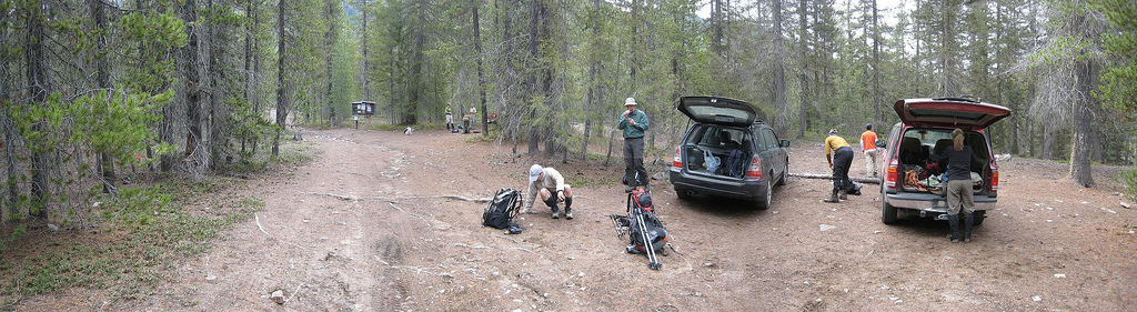 Getting ready at the trailhead 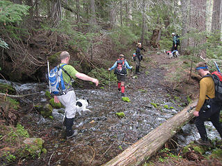 Delicate stream crossing 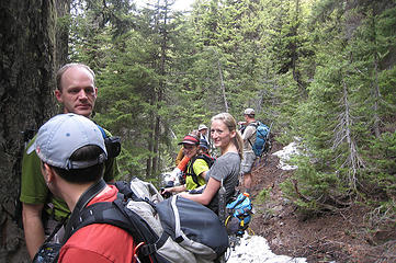 Peek-a-boo 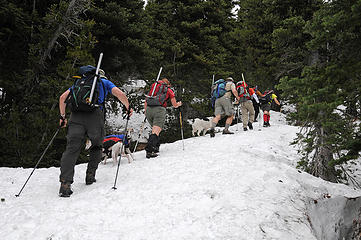 TNAB style conga line 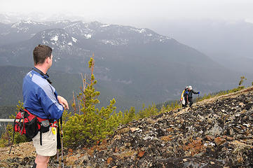 Arrival on Nelson Ridge 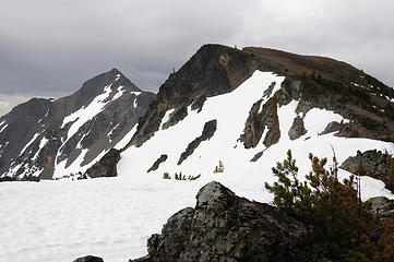 First view of Aix summit  ). Since the clouds were so thick we couldn't see for miles and miles but there were good views of Bismark Peak, 7,585', to the SW and various 7,000+ highpoints along Nelson Ridge (wow, a 7,000' unnamed highpoint, not something you see in the Olympics ). Since the clouds were so thick we couldn't see for miles and miles but there were good views of Bismark Peak, 7,585', to the SW and various 7,000+ highpoints along Nelson Ridge (wow, a 7,000' unnamed highpoint, not something you see in the Olympics  ) Looking back down into the Bumping River valley we could see Bumping Lake below and American Ridge across from us. It didn't look like a major storm was going to hit us so we set out east towards the Mount Aix summit. ) Looking back down into the Bumping River valley we could see Bumping Lake below and American Ridge across from us. It didn't look like a major storm was going to hit us so we set out east towards the Mount Aix summit.
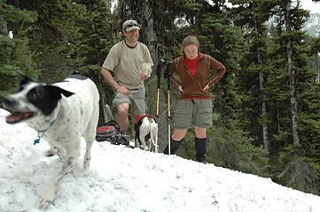
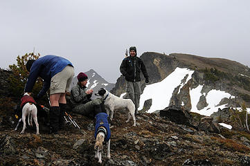 Dogs always think it's treat time 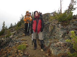 Babe modeling puzzlr's parka and her telltale D300 "bump" 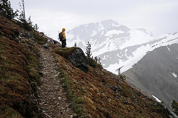 Bryan leads the way with Bismark Mtn ahead 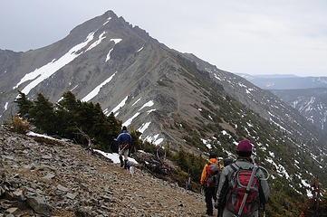 Just along the ridge 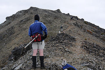 Dude eyes the last false summit 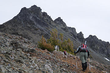 Dani gears up for the summit 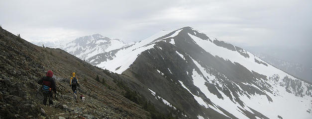 Bismark Ahead 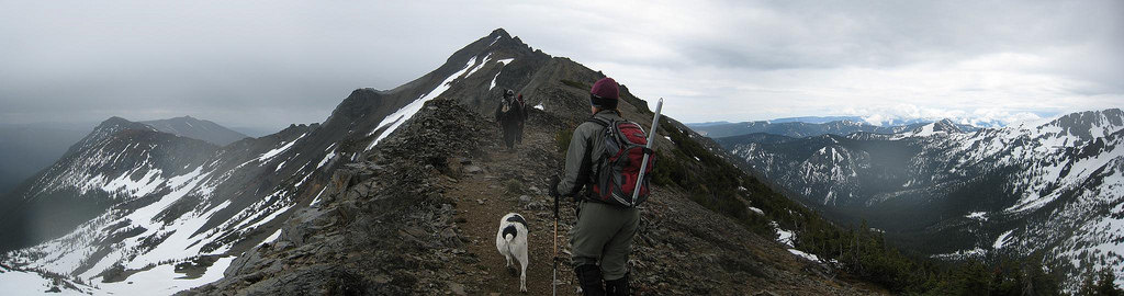 Forging ahead to the summit 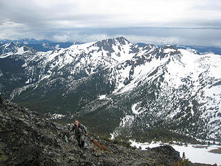 Here comes Dani 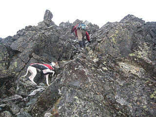 Rowena follows "mom" 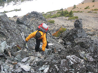 Dicey out for a stroll  . .
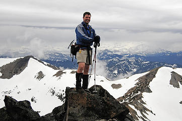 I'll give you some Schmidt Altitude 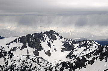 Rain clouds over Bismark 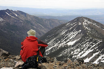 Puzzlr takes it all in 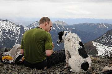 Bryan makes a new friend 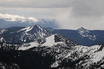 More rain heading our way? 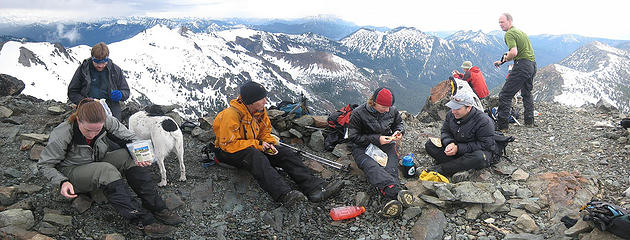 Summit chaos 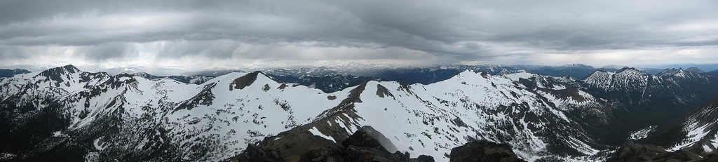 View west from summit  . Plus, the break in the weather meant we actually had a few minutes for good views of Rainier. . Plus, the break in the weather meant we actually had a few minutes for good views of Rainier.
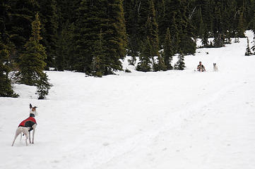
 In the loose rocks 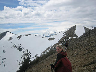 Babe on the ridge 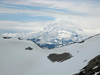 Rainier swarmed by mystery clouds 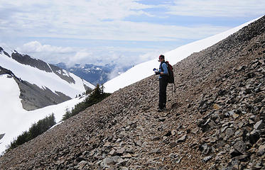 Wamtngal on trail 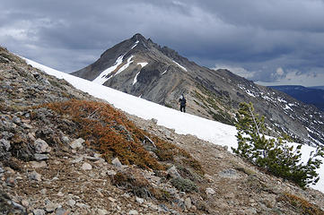 Just Todd catching up  ! As much fun as we had sledding we think the dogs had an even better time chasing the crazy humans. ! As much fun as we had sledding we think the dogs had an even better time chasing the crazy humans.
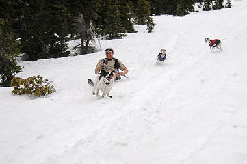 Bliss! 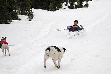 Cowabunga! 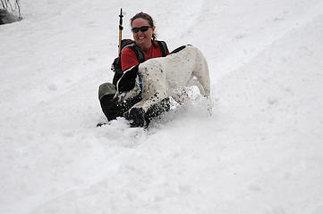 Let's go double! 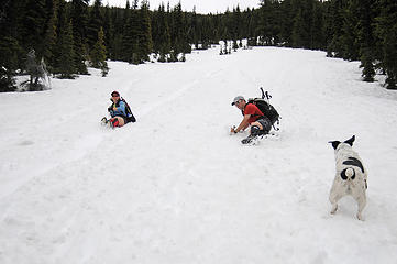 Beatcha! 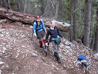 At the switchback 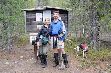 Trailhead Shot  .
flickr link to all 94 of our best photos
Trail Stats:
12 miles round trip (according to 100 Hikes in Washington's South Cascades and Olympics)
4688' total elevation gained
6 hours 25 minutes trailhead to trailhead (including breaks) .
flickr link to all 94 of our best photos
Trail Stats:
12 miles round trip (according to 100 Hikes in Washington's South Cascades and Olympics)
4688' total elevation gained
6 hours 25 minutes trailhead to trailhead (including breaks)
"Forest 101: These big wood stick things are called trees. The big rocks are called mountains, and the little rocks are their babies." Elliott from Open Season
"Forest 101: These big wood stick things are called trees. The big rocks are called mountains, and the little rocks are their babies." Elliott from Open Season
|
| Back to top |
  
|
|
Just Todd
Trowel Owl

Joined: 15 Jan 2008
Posts: 226 | TRs | Pics
Location: here. |
|
Just Todd
Trowel Owl
|
 Tue Jun 03, 2008 8:18 pm |
|
|
 Yea, mark Aix off the "done that" list Yea, mark Aix off the "done that" list  And onto the "plan to return" list.
Aix gave us a bit of everything - rain, sun, snow, dirt, snow, rocks, views, friends, photo ops.
Then, back at camp, we got And onto the "plan to return" list.
Aix gave us a bit of everything - rain, sun, snow, dirt, snow, rocks, views, friends, photo ops.
Then, back at camp, we got   
 Thanks Dude for the fab TR! Thanks Dude for the fab TR!
Sunset is an all day process.
Sunset is an all day process.
|
| Back to top |
|
|
Grizzy
Yellow Cedar Hugger

Joined: 16 Jul 2006
Posts: 1936 | TRs | Pics
Location: Switchbacks |
|
Grizzy
Yellow Cedar Hugger
|
Tue Jun 03, 2008 8:28 pm |
|
|
Very nice pictures !!! thanks for posting these...I was up there in '06, killer views from there, on clear days you can see into Oregon....Glad you had such great views with the so so weather...
All the birds have flown up and gone;
A lonely cloud floats leisurely by.
We never tire of looking at each other -
Only the mountain and I. ~Li Po~
All the birds have flown up and gone;
A lonely cloud floats leisurely by.
We never tire of looking at each other -
Only the mountain and I. ~Li Po~
|
| Back to top |
|
|
wamtngal
Member

Joined: 13 Jun 2004
Posts: 2382 | TRs | Pics
Location: somewhere |
|
wamtngal
Member
|
Tue Jun 03, 2008 8:32 pm |
|
|
I've been waiting to do Aix for years now, ever since reading about it in Pacific Northwest Hiking (or as I call it, the hiker's bible) and earmarking it because it had 5 boots (most difficult). Now it's finally on my "yay, I did it!" list.
And I couldn't have asked for a better group of peeps to tag the summit with.
Just a few pics as my camera was afraid to be out in the rain.
 GeoTom, Dani & Jasper 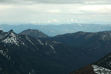 Stuart & the Enchantments waaay out there.
Opinions expressed here are my own.
Opinions expressed here are my own.
|
| Back to top |
|
|
Bryan K
Shameless Peakbagger

Joined: 29 Sep 2005
Posts: 5129 | TRs | Pics
Location: Alaska |
|
Bryan K
Shameless Peakbagger
|
Tue Jun 03, 2008 10:38 pm |
|
|
What a great hike in spite of the rain (which I'm not of hiking in). Aix is so far the highest peak for me in WA state, glad to do it with such a great group of people.
Full set of pics here
 05-31-08 Mt Aix (21) 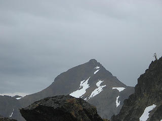 05-31-08 Mt Aix (11) 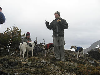 05-31-08 Mt Aix (7) 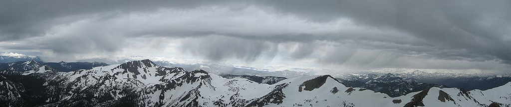 Westward sky pano
|
| Back to top |
|
|
puzzlr
Mid Fork Rocks

Joined: 13 Feb 2007
Posts: 7220 | TRs | Pics
Location: Stuck in the middle |
|
puzzlr
Mid Fork Rocks
|
Tue Jun 03, 2008 11:01 pm |
|
|
My pictures look a lot like the others. I especially like these two:
 nwhikers looking an awful lot like Japanese tourists  - I'm guessing they have a pact that boots or packs can't be removed until both are at the trailhead - I'm guessing they have a pact that boots or packs can't be removed until both are at the trailhead
 Babe waiting for Dude
|
| Back to top |
|
|
Magellan
Brutally Handsome

Joined: 26 Jul 2006
Posts: 13116 | TRs | Pics
Location: Inexorable descent |
|
Magellan
Brutally Handsome
|
Tue Jun 03, 2008 11:09 pm |
|
|
Great pano Bryan. It really conveys the mood of the day with some mountains visible, but rain obviously ready to soak NWHikers if necessary. Too bad people are too busy reading the thread wondering if the TH is driveable to read the thread about the trail. 
|
| Back to top |
|
|
mntsun
Wunderer

Joined: 08 Jul 2007
Posts: 206 | TRs | Pics
Location: Squaresville |
|
mntsun
Wunderer
|
Wed Jun 04, 2008 1:08 am |
|
|
Nice job everyone, sounds like a great event! I would have been there but was already committed to another climb (I drew the rain to me in the north to clear the weather for your trip in the south  ). ).
|
| Back to top |
|
|
Schmidt Alti-Dude
4th class poster

Joined: 06 Jul 2007
Posts: 1361 | TRs | Pics
Location: Looking for Adventure 201! |
| GeoTom wrote: | | One funny thing I remembered (at least I thought it was funny) was seeing Rowena as I was glissading towards her. She had something in her mouth, but it wasn't until I was almost to her that I realized it was a big snowball. Good thing she couldn't throw it at me. |
 Rowena wants to show off her snowball to Jasper
Anything stated by me in no way reflects the attitudes or opinions of my wife
Anything stated by me in no way reflects the attitudes or opinions of my wife
|
| Back to top |
|
|
gone
Member
Joined: 08 Feb 2008
Posts: 1051 | TRs | Pics
|
|
gone
Member
|
Wed Jun 04, 2008 12:50 pm |
|
|
Great effort and a great report - thanks for sharing it!
|
| Back to top |
|
|
bobbi
stillaGUAMish

Joined: 13 Jul 2006
Posts: 8012 | TRs | Pics
Location: olympics! |
|
bobbi
stillaGUAMish
|
Wed Jun 04, 2008 3:53 pm |
|
|
bobbi ૐ
"Today is your day! Your mountain is waiting. So
get on your way!" - Oh, the Places Youll Go! By Dr. Seuss
|
| Back to top |
|
|
Randy
Cube Rat

Joined: 18 Dec 2001
Posts: 2910 | TRs | Pics
Location: Near the Siamangs |
|
Randy
Cube Rat
|
Wed Jun 04, 2008 4:46 pm |
|
|
You guys are ballers.
|
| Back to top |
|
|
Mark Griffith
(Embrace yourself)

Joined: 14 Mar 2005
Posts: 853 | TRs | Pics
Location: Issaquah |
Great trip report, looks like some very nice ridgeline walking! I had to smile at the Dude and his shorts.
|
| Back to top |
|
|
puzzlr
Mid Fork Rocks
Joined: 13 Feb 2007
Posts: 7220 | TRs | Pics
Location: Stuck in the middle |
|
puzzlr
Mid Fork Rocks
|
Wed Jun 04, 2008 9:55 pm |
|
|
I laugh every time I see this  . Dicey doing a Kilroy Was Here impersonation . Dicey doing a Kilroy Was Here impersonation
|
| Back to top |
|
|
Gil
Member

Joined: 29 Sep 2004
Posts: 4062 | TRs | Pics
|
|
Gil
Member
|
Wed Jun 04, 2008 11:01 pm |
|
|
Great TR!
Friends help the miles go easier.
Klahini
Friends help the miles go easier.
Klahini
|
| Back to top |
|
|
|
|


 way to go nwhikers for being #1 blazers to the summit in 2008!
