| Previous :: Next Topic |
| Author |
Message |
Opus
Wannabe


Joined: 04 Mar 2006
Posts: 3700 | TRs | Pics
Location: The big rock candy mountain |
|
Opus
Wannabe
|
 Sun Jun 15, 2008 10:24 pm |
|
|
With a weekend of beautiful weather forecast at last I wanted to get out for another high camp, to heck with the snow! Where to go proved to be more difficult to decide. We finally set our sights on Mt. Ann in the North Cascades. Ann is the unofficial name for the 5840ft peak along the ridge south of Lake Ann. After some last minute wrangling Suzanne dropped off, but Joanna decided to join in and attempt the trip as a dayhike. She also brought a new friend along - it was his first trip off trail, first scramble, and first time using an ice axe. We suspect he didn't know what he was in for!
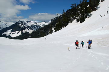
Parking just above the upper Baker ski area, we arrived just as the gray clouds began to part. It was already warm and the snow soft when we set off up a snowcat track towards Austin pass. Mazama dome and Table mountain hung on the ridge, glowing in the sun. After a short climb we arrived at Austin Pass and looked down the valley. We were still considering a loop trip including the valley and traversing Shuksan arm. Following some discussion we opted to go in via the valley; we were unsure about following the arm.
Dropping steeply down the valley on soft snow we reached the floor quickly. David, Joanna's friend, slipped and had his first self-arrest at one point. That behind us we walked onwards as Shuksan unsheathed its clouds for us. We were all drooling over what was ahead. Mt. Ann was floating in and out of the remaining clouds. Traveling the valley floor was easy and offered surprisingly good views. After a few miles, and a lunch break with a great Baker view, we arrived at the base of the ridge. Some melting meadows created a few mini-crevasses to step over below.
Once across we began our ascent, staying to the left near the slopes of Shuksan arm. The summer trail ascends the drainage to the south but we felt this was a more direct way up. The snow was a little slushy but held steps very well. High above cornices ran the whole ridge. Our travel seemed to be going very fast - and soon I saw that we were simply cresting a false ridge. We were now in a large snow bowl with the ridge over Ann still a few hundred feet up. Happily that went quickly and we were soon looking down onto frozen Lake Ann.
The perimeter of the lake was melting very slightly but the valley is still locked in snow. Across the way the Curtis Glacier smiled at us, hanging high on the side of Shuksan. The mountain itself had covered itself once again with clouds as we climbed up on the ridge towards a stand of trees in search of a camp. We found a dynamite spot but became greedy and ascended a little higher to a nicer one. Still feeling greedy we went higher out of the trees, until we found a flat spot with Shuksan and Baker views that knocked our soggy socks off. There was almost no wind and a good forecast so we opted to camp here in the open. Joanna and David went on ahead towards Ann while Trailpair and I pitched our camp.
Tents assembled and anchored we threw our extra gear inside and started after them. In our haste to drool over the dramatic ridge we neglected to melt some snow, which we would soon regret. Further on we could see Joanna and David waiting on the ridge below Han Peak (Pt.5681). Clouds were billowing in and out, constantly changing the light, as we walked and inducing some shutter delay. The ridge itself was slower travel with many small ups and downs. After half an hour we caught up. It was around 3pm and they'd decided to head back, knowing they had a 3+ hour hike back to the car. Also ahead they'd scoped out the traverse below Han and decided that was not to their liking.
We said our goodbyes and I walked out to see the traverse. It was steep but the snow held good steps and was not slidey. I went ahead slowly, setting steps deeply as I went. The trip was very tedious, taking around a half hour to cross the slope. On the other side I fell behind as Bob and Kolleen kicked up the slope onto the shoulder of Han. Up here we could see we had a ways to go, and several more ups an downs, before reaching Ann itself. We decided to push on for Ann and get Han on the way back. Quickly giving back another hundred or so feet we started across the ridge. The lighting here was incredibly dramatic from the frothing clouds and I again fell behind. Purely for photographic reasons of course, not laziness.  Nearly to Ann the ridge narrowed and we could see some tarns in the valley beginning to melt. Ahead was a rocky, snow free bump. Kolleen led the traverse around the right and quickly found herself in a waist deep hole. We ended up walking up and over the rocks. Once on the other side we could see this was the only way - the route on the right side ended in a corniced drop. Now we were finally at the base of Ann! In the flat lighting though it was very hard to decipher the slope. Was it steep? Is it a trick of the light?
As it turns out it was fairly steep. Bob kicked in some great steps and we made a rising traverse to the south, reaching a small plateau on the ridge. From here we found a path through the trees on our right and kicked up to the summit. The views were pretty incredible, though more local than we were hoping for. Across the valley Baker's glaciers were glowing. Baker lake was sparkling to the south. Even Shuksan peeked out a little. It had taken plenty of time to get here, nearly two hours from camp, but was worth it. I'd hauled along my Jetboil and melted out enough water for the return trip. We were all now fairly dehydrated and regretting our earlier haste.
We found a better descent route off the summit and began our return trip along the ridge, tired legs feeling all the little bumps along the way. I hadn't brought my GPS this time. I wished I had to figure all the little elevation gains along the way - they must have added up to a significant number. Making good time we found ourselves again at the base of Han. Looking north-east we could see our goal. It was very tempting to try traversing the west slope of Han. This would shave significant distance and time over backtracking. The slope didn't seem too much steeper, but after some waffling we decided to backtrack. One positive outcome was tagging Han peak, making it a two-summit trip! more than just a bumpy, rocky obstacle, it turned out to be a very nice little summit.
Dropping down again we were faced with the return traverse. This time though we had steps to follow. They had frozen in nicely and travel was much easier. We were making good time and approached our tents around 6:30. All three of us were feeling the many ups and downs, climbs, and dehydration. Finally it was all downhill to camp where we dropped packs, changed into warmer clothing, and melted snow. It was great to finally relax after nine hours hiking time. It was clear now that our hopes for a great alpenglow sunset would be dashed by the descending clouds, but we were still in high spirits.
We relaxed around camp as the clouds continued to drop, then retired to our tents. It was still light of course, but we all were sporting very wet boots from the slushy snow and were happy to warm our cold feet in the sleeping bags. My feet were very pruney and cold, but that was a small discomfort. Bob on the other hand was experiencing some horrible leg cramps and back spasms, likely from dehydration. All three of us were feeling stiff, dehydrated, and sun-baked but still happy to be out in such beautiful terrain. We fell asleep to socked in skies, hoping they'd drop below camp overnight.
My liquid alarm clock woke me around 12:45am. I opened my tent and was greeted with a glowing nearly full moon! The clouds had largely faded and the stars were out! I'd hauled my tripod along expecting a great sunset and instead pressed it into service for a star-trail photo over Shuksan. The moon was so bright though that I couldn't manage a very long exposure. I was encouraged enough now to set my watch alarm for 6am hoping for a great sunrise.
Waking at five I opened the tent again, this time greeted with nothing but fog. Sadly no sunrise for us either. I shut off my alarm and crawled back into the bag for some more sleep. We all rolled out of bed sometime after seven and puttered around making breakfast. The clouds were slowly rising as we packed and started our descent. By the time we were off the ridge the sky was rapidly turning blue and Shuksan popped out to say goodbye. All through the valley as we walked out it watched us. A parting view was nice of course, but it also reminded us of the fantastic views the clouds hid over the trip.
Out tired legs finally carried us over the last bit of gain to Austin pass and we were on our way back down to the car. A few split-board skiers were on their way up and a group of goths were gathered around a melted picnic table halfway down. They had a small Christmas tree setup, and were also sporting vampire fangs.
Nearly to Ann the ridge narrowed and we could see some tarns in the valley beginning to melt. Ahead was a rocky, snow free bump. Kolleen led the traverse around the right and quickly found herself in a waist deep hole. We ended up walking up and over the rocks. Once on the other side we could see this was the only way - the route on the right side ended in a corniced drop. Now we were finally at the base of Ann! In the flat lighting though it was very hard to decipher the slope. Was it steep? Is it a trick of the light?
As it turns out it was fairly steep. Bob kicked in some great steps and we made a rising traverse to the south, reaching a small plateau on the ridge. From here we found a path through the trees on our right and kicked up to the summit. The views were pretty incredible, though more local than we were hoping for. Across the valley Baker's glaciers were glowing. Baker lake was sparkling to the south. Even Shuksan peeked out a little. It had taken plenty of time to get here, nearly two hours from camp, but was worth it. I'd hauled along my Jetboil and melted out enough water for the return trip. We were all now fairly dehydrated and regretting our earlier haste.
We found a better descent route off the summit and began our return trip along the ridge, tired legs feeling all the little bumps along the way. I hadn't brought my GPS this time. I wished I had to figure all the little elevation gains along the way - they must have added up to a significant number. Making good time we found ourselves again at the base of Han. Looking north-east we could see our goal. It was very tempting to try traversing the west slope of Han. This would shave significant distance and time over backtracking. The slope didn't seem too much steeper, but after some waffling we decided to backtrack. One positive outcome was tagging Han peak, making it a two-summit trip! more than just a bumpy, rocky obstacle, it turned out to be a very nice little summit.
Dropping down again we were faced with the return traverse. This time though we had steps to follow. They had frozen in nicely and travel was much easier. We were making good time and approached our tents around 6:30. All three of us were feeling the many ups and downs, climbs, and dehydration. Finally it was all downhill to camp where we dropped packs, changed into warmer clothing, and melted snow. It was great to finally relax after nine hours hiking time. It was clear now that our hopes for a great alpenglow sunset would be dashed by the descending clouds, but we were still in high spirits.
We relaxed around camp as the clouds continued to drop, then retired to our tents. It was still light of course, but we all were sporting very wet boots from the slushy snow and were happy to warm our cold feet in the sleeping bags. My feet were very pruney and cold, but that was a small discomfort. Bob on the other hand was experiencing some horrible leg cramps and back spasms, likely from dehydration. All three of us were feeling stiff, dehydrated, and sun-baked but still happy to be out in such beautiful terrain. We fell asleep to socked in skies, hoping they'd drop below camp overnight.
My liquid alarm clock woke me around 12:45am. I opened my tent and was greeted with a glowing nearly full moon! The clouds had largely faded and the stars were out! I'd hauled my tripod along expecting a great sunset and instead pressed it into service for a star-trail photo over Shuksan. The moon was so bright though that I couldn't manage a very long exposure. I was encouraged enough now to set my watch alarm for 6am hoping for a great sunrise.
Waking at five I opened the tent again, this time greeted with nothing but fog. Sadly no sunrise for us either. I shut off my alarm and crawled back into the bag for some more sleep. We all rolled out of bed sometime after seven and puttered around making breakfast. The clouds were slowly rising as we packed and started our descent. By the time we were off the ridge the sky was rapidly turning blue and Shuksan popped out to say goodbye. All through the valley as we walked out it watched us. A parting view was nice of course, but it also reminded us of the fantastic views the clouds hid over the trip.
Out tired legs finally carried us over the last bit of gain to Austin pass and we were on our way back down to the car. A few split-board skiers were on their way up and a group of goths were gathered around a melted picnic table halfway down. They had a small Christmas tree setup, and were also sporting vampire fangs.  But our minds were focused on the dry socks in the car and continued on. Once sporting dry footwear we payed a visit to the still frozen Picture lake and headed home.
While we didn't get the beautiful sunrise and sunset photos I'd hoped for, the trip was indeed spectacular. The ridge route is very interesting with peaks in every direction. The billowing clouds constantly changed the light, making even the same peak look new every few minutes. I can only imagine the scenery in the fall, or on a sunnier day.
I was very shutter happy so I'll post a bunch here, and link the rest. Click here to see all 75+ photos. But our minds were focused on the dry socks in the car and continued on. Once sporting dry footwear we payed a visit to the still frozen Picture lake and headed home.
While we didn't get the beautiful sunrise and sunset photos I'd hoped for, the trip was indeed spectacular. The ridge route is very interesting with peaks in every direction. The billowing clouds constantly changed the light, making even the same peak look new every few minutes. I can only imagine the scenery in the fall, or on a sunnier day.
I was very shutter happy so I'll post a bunch here, and link the rest. Click here to see all 75+ photos.
 Reflection  Valley floor  Big step  Han peak and Mt. Ann  Snow bowl  Frozen Lake Ann  Surveying the route  Snow dunes  Han peak backside  Summit sighted  Baker closeup  Summit view  Heading down  Glowing summit  Blue skies  Summit tracks  Tiny tents  Traversing  Ridge walk  Han peak  Fading Mt. Ann  Shuksan and stars  Morning light  Camoflauge lessons  Bright skies  Winters revenge  Picture Lake
|
| Back to top |
  
|
|
Sadie's Driver
Sadie's Driver

Joined: 24 Apr 2006
Posts: 1763 | TRs | Pics
Location: Welcome Pass |
Fabulous report, Opus! Sorry I missed out on that one. However, dirt was a pleasant change!!!  
Four-paw buddy lets me tag along!
Four-paw buddy lets me tag along!
|
| Back to top |
|
|
Magellan
Brutally Handsome

Joined: 26 Jul 2006
Posts: 13116 | TRs | Pics
Location: Inexorable descent |
|
Magellan
Brutally Handsome
|
Sun Jun 15, 2008 11:10 pm |
|
|
Awesome!! Can't wait for more.
|
| Back to top |
|
|
detekt
Member

Joined: 26 Feb 2004
Posts: 291 | TRs | Pics
Location: Mountlake Terrace |
|
detekt
Member
|
Mon Jun 16, 2008 7:23 am |
|
|
 "Shuksan and stars"- Great shot! "Shuksan and stars"- Great shot!
|
| Back to top |
|
|
Middle E
no more moustache

Joined: 10 Feb 2008
Posts: 432 | TRs | Pics
Location: Seattle, WA |
|
Middle E
no more moustache
|
Mon Jun 16, 2008 8:07 am |
|
|
Nice TR. What was all that white wet-looking stuff covering everything in sight?
pithy yet insightful signature
pithy yet insightful signature
|
| Back to top |
|
|
TrailPair
Member

Joined: 17 Apr 2005
Posts: 1699 | TRs | Pics
|
All we can say is WOW! Other than the evening and morning clouds, this was a perfect trip!
These are just a few of our favorite photos:
 K, Joanna and David below Lk. Ann 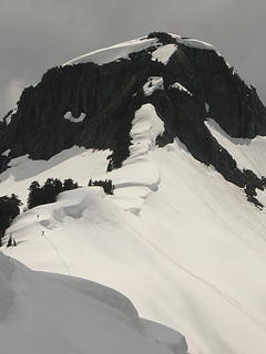 Joanna and David on the ridge 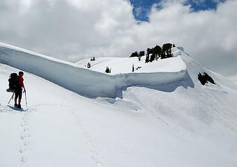 Ridge above Lake Ann 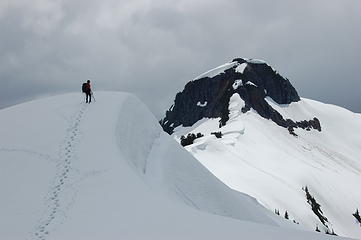 Han Pt. 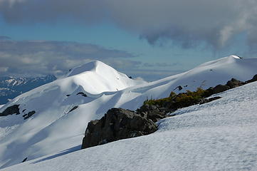 View south 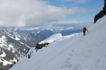 Steep traverse 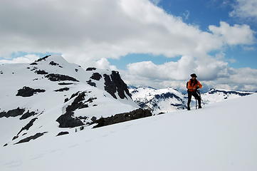 Blue skies 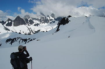 Opus 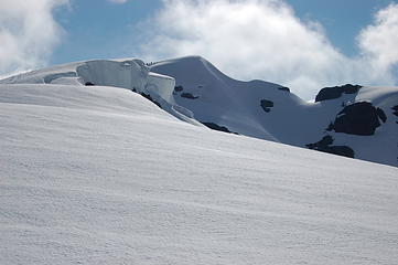 Evening light on Mt. Ann 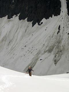 Opus with Mt. Shuksan beyond 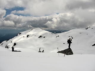 Opus 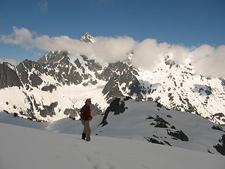 Bob on Mt. Ann Summit 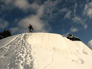 Descending ridge to camp 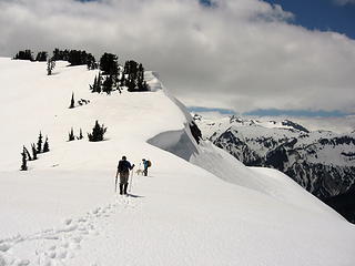 David and Joanna 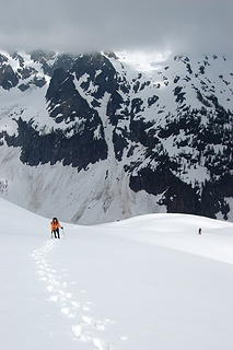 K and Opus on shoulder of Han Pt. 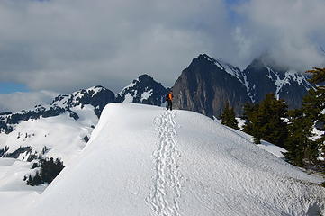 Going back to campsite 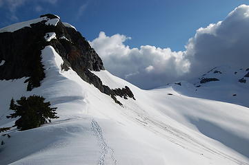 Evening light 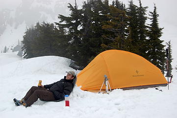 David's traditional camp beer
This thing called work is interfering with my play
This thing called work is interfering with my play
|
| Back to top |
|
|
Elvis
Shuffl'n

Joined: 09 Jun 2004
Posts: 1804 | TRs | Pics
Location: del Boca Vista |
|
Elvis
Shuffl'n
|
Mon Jun 16, 2008 8:10 pm |
|
|
Fantastic!!
Thanks for sharing the story, route and amazing photos.
"Ill habits gather unseen degrees, as brooks make rivers, rivers run to seas." ~John Dryden
My Trip List
"Ill habits gather unseen degrees, as brooks make rivers, rivers run to seas." ~John Dryden
My Trip List
|
| Back to top |
|
|
Opus
Wannabe
Joined: 04 Mar 2006
Posts: 3700 | TRs | Pics
Location: The big rock candy mountain |
|
Opus
Wannabe
|
Mon Jun 16, 2008 9:03 pm |
|
|
I didn't carry my GPS for this trip, but here's a rough estimate of our route to Ann. I believe final stats are around 11 miles round trip with about 4000 ft of gain counting all the little ups and downs along the way. It certainly felt much longer than that though, likely due to the soft snow we had and our own dehydration. While it's snow covered it would make a great ski tour.
 Rough route (not GPS tracks)
|
| Back to top |
|
|
Karen²
A Real Canadian Girl
Joined: 25 Jul 2002
Posts: 1367 | TRs | Pics
Location: Behind the Lens |
|
Karen²
A Real Canadian Girl
|
Mon Jun 16, 2008 9:13 pm |
|
|
Wowie...fabulous photos! Encore, encore!
|
| Back to top |
|
|
twodogdad
Member

Joined: 21 Nov 2006
Posts: 846 | TRs | Pics
Location: seattle |
|
twodogdad
Member
|
Tue Jun 17, 2008 9:31 pm ann
|
|
|
A classic 2dd
|
| Back to top |
|
|
Schmidt Alti-Babe
The Ice Queen
Joined: 11 Mar 2008
Posts: 606 | TRs | Pics
Location: Buried by backlogged pictures |
Beautiful, just beautiful. I love the North Cascades. 
|
| Back to top |
|
|
TrailPair
Member
Joined: 17 Apr 2005
Posts: 1699 | TRs | Pics
|
| Schmidt Alti-Babe wrote: | | Beautiful, just beautiful. I love the North Cascades. |
We agree....this is why we like to go to the North Cascades....and why we save our trips to the area for when the weather cooperates. 
This thing called work is interfering with my play
This thing called work is interfering with my play
|
| Back to top |
|
|
Mark Griffith
(Embrace yourself)
Joined: 14 Mar 2005
Posts: 853 | TRs | Pics
Location: Issaquah |
Awesome photos! (and a great trip report)
|
| Back to top |
|
|
|
|
You cannot post new topics in this forum
You cannot reply to topics in this forum
You cannot edit your posts in this forum
You cannot delete your posts in this forum
You cannot vote in polls in this forum
|
Disclosure: As an Amazon Associate NWHikers.net earns from qualifying purchases when you use our link(s). |


