| Previous :: Next Topic |
| Author |
Message |
ADrewzki
Snow angels are hot


Joined: 27 Apr 2007
Posts: 188 | TRs | Pics
Location: Denver |
|
ADrewzki
Snow angels are hot
|
 Thu Jul 17, 2008 10:27 am |
|
|
It seems like this was a day meant for me to get lost. I left the house at 8:30am, stopped by the Quilcene ranger station for my pass and a map, and headed up to the Big Quilcene Trail. At the last fork to the trail, I ended up taking a right instead of a left and that delayed me another twenty minutes. Eventually, I found my way to the parking lot. My vehicular mounted ambient heat indicator read 65F. I grabbed my water for what I thought was going to be a leisurely 3-4 mile hike (boy was I surprised!) up to Buckhorn, test out the new camera, and then to retrieve the NWHikers Olympic Registry.
The trail itself is not difficult, just long. Well, longer than what I had pictured. I passed by the first two camps without much excitement. Eventually I came out on this meadow which is about 30 minutes from the pass. Lots of colors and smells due to all the flowers. Very pretty indeed! And then you get to the signpost which would signify the pass.
I took a right towards Buckhorn and started climbing. I took the lower trail towards Buckhorn Pass when I saw someone coming down the upper trail with her dog. She informed me that the upper trail would take me to Buckhorn Mt and the lower one would take me to the pass. So I backtracked again and set out towards the peak. I met up with her group (John, Erin, and Eric) later on as I was descending and she claimed to have seen me before. Turns out she was on a TNAB hike for Snoqualmie a few weeks back and had caught a glimpse of me there. Small world!!
I made it to the peak of Buckhorn pretty quickly and scuttled around. I saw the cairn that Opus has posted about on his Marmot Pass TR. I took a couple of pictures and eyeballed the peak where I was headed to next to get the registry. Total time to summit Buckhorn was about 4:30. I had a little lunch at what I have dubbed "lunch rock" and then skirted the ridge towards Peak 6559.
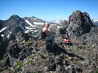
Well, turns out that I did not read MtnWkr's post very well. You're supposed to follow the ridge all the way to the peak. Well, I took the trail and subsequently lost about 500ft. The entire time, I was thinking, "Surely this branches off and heads up the mountain...." I eventually got to the east side of 6559 and it just didn't seem like a good idea to keep heading down. So I just started bushwhacking up the hillside. Lots of loose dirt and rocks made for a pretty rough climb. Only about a 1000ft so it wasn't that bad. I emerged back on the ridge line where I should've been and felt stupid and tired.
Turns out I had circumvented 6470 altogether and was on the ridge between 6470 and 6559. Getting ever closer to my goal, I trudged on. I came to what I thought was the peak of 6559. Behind me were a couple of rock outcroppings that didn't really look safe to explore so I doubted that MtnWkr had put it there. I checked all the places I could get to on the north face and to my dismay found nothing.  I kept looking for an hour or so until I hit my "I need to start heading back" time at 4:30pm. Sadly enough, I guess it just wasn't my day.
Heading back towards Buckhorn, I followed the ridge like I was supposed to but missed the fork to Marmot Pass. So I ended up climbing Buckhorn again about halfway before it clicked in my head that this probably isn't right. So I came back down and looked around. I had gotten it into my head that maybe climbing Buckhorn was right and the trail was on the other side. So I started climbing it again. About halfway up, I thought I saw a chute/trail that I could've used. I did a quick traverse to the south side only to find out that it was only a chute. Again, doubt filled my mind and I went back and headed down. The frustrating thing was that I could see the signpost at the Pass from where I stood. So gritting my teeth, I climbed Buckhorn AGAIN and sat down at the top. I pulled out my map, my GPS and got a bearing on where I should be and where I was. Turns out, climbing Buckhorn an additional 3 times was NOT the right answer. So I headed down again, backtracked all the way to the ridge and TA-DA! There was the trail I was looking for. Awesome.
By this time, due to all the unneeded climbing and my water supply running out, my legs were starting to cramp up. I ended up having to sit down and rub my legs every 15 minutes. I started heading down hopefully for the last time without any problems. I was starting to worry about what I was going to do for water when I got to Camp Mystery. There was a couple (Pat and Rick) vacationing from Michigan. They took the time to fill up my water bottle with their filter and I cannot tell you how much that meant to me. It felt like a giant weight had been lifted from my shoulders. Thanks again.
Started down again feeling a little better. My muscles were still a little tight in my legs but my feet had actually started to really bother me. At the parking lot, I would come to find out that I had huge blisters on my heels and my toes. I tried not to let it bother me. I mean, I still had almost four miles to go. Couldn't let a little pain deter me. Eventually, I had to sit down and take a break. That's when John, Erin, and Eric happened by again. They were just what I needed to motivate me and I followed them all the way down to the bottom.
Everything worked out fine other than the fact that I feel 80yrs old this morning. Maybe next week if the registry is still there, I'll think about reattempting it. I kept looking for an hour or so until I hit my "I need to start heading back" time at 4:30pm. Sadly enough, I guess it just wasn't my day.
Heading back towards Buckhorn, I followed the ridge like I was supposed to but missed the fork to Marmot Pass. So I ended up climbing Buckhorn again about halfway before it clicked in my head that this probably isn't right. So I came back down and looked around. I had gotten it into my head that maybe climbing Buckhorn was right and the trail was on the other side. So I started climbing it again. About halfway up, I thought I saw a chute/trail that I could've used. I did a quick traverse to the south side only to find out that it was only a chute. Again, doubt filled my mind and I went back and headed down. The frustrating thing was that I could see the signpost at the Pass from where I stood. So gritting my teeth, I climbed Buckhorn AGAIN and sat down at the top. I pulled out my map, my GPS and got a bearing on where I should be and where I was. Turns out, climbing Buckhorn an additional 3 times was NOT the right answer. So I headed down again, backtracked all the way to the ridge and TA-DA! There was the trail I was looking for. Awesome.
By this time, due to all the unneeded climbing and my water supply running out, my legs were starting to cramp up. I ended up having to sit down and rub my legs every 15 minutes. I started heading down hopefully for the last time without any problems. I was starting to worry about what I was going to do for water when I got to Camp Mystery. There was a couple (Pat and Rick) vacationing from Michigan. They took the time to fill up my water bottle with their filter and I cannot tell you how much that meant to me. It felt like a giant weight had been lifted from my shoulders. Thanks again.
Started down again feeling a little better. My muscles were still a little tight in my legs but my feet had actually started to really bother me. At the parking lot, I would come to find out that I had huge blisters on my heels and my toes. I tried not to let it bother me. I mean, I still had almost four miles to go. Couldn't let a little pain deter me. Eventually, I had to sit down and take a break. That's when John, Erin, and Eric happened by again. They were just what I needed to motivate me and I followed them all the way down to the bottom.
Everything worked out fine other than the fact that I feel 80yrs old this morning. Maybe next week if the registry is still there, I'll think about reattempting it.  Total miles hiked: ~18mi. Total time: 9hr 51min Total miles hiked: ~18mi. Total time: 9hr 51min
 Welcome to Buckhorn  I HATE this plant! 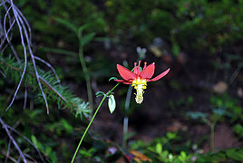 Columbine?  Lupin  Thistle  Camp No-one-around  The big meadow before the pass  Cairn at top of Buckhorn  "Lunch rock"  What lake is this?  Obligatory Rainer shot  Ridgeline to 6559  Looking at the north face of what I thought was 6559  North face again  1 label Looking back at Buckhorn from 6559  A marmot!!
|
| Back to top |
  
|
|
bobbi
stillaGUAMish

Joined: 13 Jul 2006
Posts: 8012 | TRs | Pics
Location: olympics! |
|
bobbi
stillaGUAMish
|
Thu Jul 17, 2008 10:36 am |
|
|
it's a good thing that i'm off work because reading your TR tired me out completely! great attempt to claim the olympic mountains traveling summit register though. my buddy and i are planning to head there this weekend and get it. planning is the key word!
great job nonetheless!
bobbi ૐ
"Today is your day! Your mountain is waiting. So
get on your way!" - Oh, the Places Youll Go! By Dr. Seuss
bobbi ૐ
"Today is your day! Your mountain is waiting. So
get on your way!" - Oh, the Places Youll Go! By Dr. Seuss
|
| Back to top |
|
|
mtnwkr
Member

Joined: 27 Jul 2004
Posts: 1332 | TRs | Pics
Location: Bremerton. I'm the Lorax, I speak for the trees |
|
mtnwkr
Member
|
Thu Jul 17, 2008 11:18 am |
|
|
Nice try! Thanks for playing...  That un-named lake is buckhorn. Did you check your elevation to see if you were in fact on 6559? maybe someone claimed it before you got there?
 look for this spot!
There's a mostly unspoken acknowledgment among the voluntarily impoverished that it's better to be fiscally poor yet rich in experience-living the dream-than to be traditionally wealthy but live separate from one's passions.
There's a mostly unspoken acknowledgment among the voluntarily impoverished that it's better to be fiscally poor yet rich in experience-living the dream-than to be traditionally wealthy but live separate from one's passions.
|
| Back to top |
|
|
huron
Member

Joined: 13 Sep 2004
Posts: 1037 | TRs | Pics
|
|
huron
Member
|
Thu Jul 17, 2008 11:38 am |
|
|
Drewzki lost? Impossible.  Like your pics, lost or not.
|
| Back to top |
|
|
Dane
Other

Joined: 14 Mar 2006
Posts: 2466 | TRs | Pics
Location: Seattle |
|
Dane
Other
|
Thu Jul 17, 2008 3:22 pm |
|
|
| ADrewzki wrote: | | I pulled out my map, my GPS and got a bearing on where I should be and where I was. Turns out, climbing Buckhorn an additional 3 times was NOT the right answer. |
 Great report. Bummer you didn't find the register, but at least you got a good story out of it...
Without judgement what would we do? We would be forced to look at ourselves...
-Death
Without judgement what would we do? We would be forced to look at ourselves...
-Death
|
| Back to top |
|
|
ADrewzki
Snow angels are hot
Joined: 27 Apr 2007
Posts: 188 | TRs | Pics
Location: Denver |
|
ADrewzki
Snow angels are hot
|
Thu Jul 17, 2008 4:48 pm |
|
|
MtnWkr, judging by your picture, I would say that I probably wasn't on the right peak. Or maybe I just wasn't far enough on the ridge. Who knows.
*edit* Ok, looking at my GPS track, I would say the peak I was on was 6474ft in elevation. Definitely was not in the right place.
Magnum, I don't need any of your sass now, y'hear?
|
| Back to top |
|
|
Roald
Member

Joined: 06 Aug 2007
Posts: 367 | TRs | Pics
Location: Seattle |
|
Roald
Member
|
Fri Jul 18, 2008 5:46 pm |
|
|
ADrewzki, it was a pleasure to meet you up there! Even as you described your so-called "bust" as we walked to the car, it was apparent that you had a really cool adventure looking for the register. Just roaming in such high country - on such a good day - seems like a successful day to me. Nice pictures, too!
|
| Back to top |
|
|
rickandpat
Rick and Pat

Joined: 29 May 2008
Posts: 20 | TRs | Pics
Location: Jackson, MI |
Glad to help, anytime! We loved our first backpacking trip to the Olympics, will definitely be back. After reading another TR here, I'm really glad we went mid-week, tons less traffic.
Pat
|
| Back to top |
|
|
|
|
You cannot post new topics in this forum
You cannot reply to topics in this forum
You cannot edit your posts in this forum
You cannot delete your posts in this forum
You cannot vote in polls in this forum
|
Disclosure: As an Amazon Associate NWHikers.net earns from qualifying purchases when you use our link(s). |


