| Previous :: Next Topic |
| Author |
Message |
trailjunky
Backcountry Bumpkin'


Joined: 14 Jun 2004
Posts: 1124 | TRs | Pics
Location: timberline |
|
trailjunky
Backcountry Bumpkin'
|
 Thu Jul 31, 2008 2:37 am |
|
|
I had a few days off so I decided to check with my brother to see if our schedules would jive, well they did! Where to go? Lots of locations came about but we are still limited by snow conditions in some places. Connor needed to log miles to prepare for his trek of the John Muir trail in a couple of weeks, so we were looking for something with good mileage. After a call to a few ranger stations it sounded like the 25 mile loop through the Siamese Lakes in the proposed Great Burn Wilderness Area along the Bitterroot Divide would be the ticket.
The alarm sounded about 4:15am and after the routine stop at Safeway for the days lunch, some bagels, and lattes we were on the way. Once over Fourth of July, and Lookout Pass we located exit 66 for Fish Creek Road, and eventually the trailhead at Clearwater Crossing Campground, a popular place for horse packers. The entire drive to the trailhead was under overcast skies with the constant threat of rain. The forecast called for a 30 percent chance of thundershowers so the raingear was always at the ready, but I must admit, it was nice to have cool temps for the beginning of our long haul into Lower Siamese Lake.
On the trail by 10am we picked up the main trail #101 up West Fork Fish Creek. The creek was pretty swollen, running the banks full with little to no option for crossing without a crotch high ford through swift water, not a good sign. Once across the hiker only suspension bridge we went right at the first unsigned intersection. The forest canopy was impressive, a lot more lush than I expected, which was a real treat. It didnt take long to reach the first and only crossing of the West Fork on a sturdy bridge about 3 miles in. After dropping the packs we took a quick break to rehydrate before getting back on the trail.
Just beyond the bridge we passed the perfect swimming/fishing hole. We were both a little disappointed we didnt have time to wet a line considering we were attempting the loop and wouldnt be back to enjoy it later. Beyond the fishing hole we passed a couple of trail junctions but always stuck to the main trail leading toward Foley Basin. At about five miles we reached the largest avalanche chute I had ever seen, its amazing what mother nature is capable of, very impressive. Not long past the avalanche we began hitting the cedar groves, which grew more impressive the further back we traveled. This trail has some of the best old growth cedar groves Id seen in the Inland Northwest. Its amazing these giants were able to survive the fire of 1910 that swept through the area wiping out 3 millions acres in just 2 days!
After a little over 6 miles we stopped near one of our numerous creek crossing to enjoy a quick lunch. To this point the creek crossings were becoming a nuisance, and would continue to stay that way throughout the rest of the trip, it was becoming almost impossible to not get water over your boot tops. Approaching the nine mile mark the trail began with the switchbacks, none of which appeared on the USGS map or in the guide book. The grade was always gentle along the climb, and if it wouldnt have been for the chin high brush and blow downs it would have been a breeze. Once through the switchbacks we reached a Y and went right at the unsigned junction for Lower Siamese Lake. Not far past the turn we reached the headwall of Foley Basin in a parkland meadow amongst wildflowers and tall cliffs. After crossing the only significant snowfield we doglegged right and began our climb, past lupine, to a small insignificant pass/shoulder. It was here were the views began to open up down the valley we had just climbed, it was awesome. Connor and I both expected to find wildlife foraging in the meadows below, though we never saw anything. We knew we werent alone, tracks from deer, elk, wolf/coyote, and a rather large cougar were all along the trail, but thats Montana for you. Once over the pass/shoulder we made a couple of ups and downs past snow patches before making the final climb over a knoll to our first views of Lower Siamese Lake. Once over the outlet stream we were finally in camp.
At first I wasnt too impressed, but I had just traveled 12.5 miles with over 3,000 feet of elevation gain. About the only thing I was impressed with at that point was a nice sized log to put my tired ass on. After having a chance to rest I pitched my tent next a rather large bear track, ate some dinner, and hung my food. At this point the area was beginning to grow on me, the view from where our bear line hung was impressive. The west end of the lake held a decent cascade carrying melt water from the upper lake, and above that, the Bitterroot Divide. Lower Siamese Lake is a rather large lake, not something I was used to finding in the high alpine country. Back in camp we were too tired to make a fire, and enjoyed a couple gin fizz before calling it quits and retiring to a rather chilly night in my 45 degree bag.
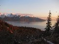
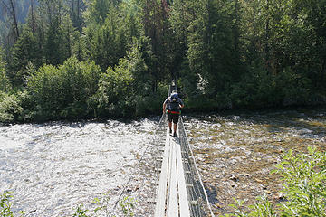 Connor crosses the West Fork Fish Creek on the hiker only suspension bridge, proposed Great Burn Wilderness Area, Montana. 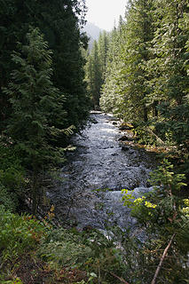 West Fork Fish Creek, proposed Great Burn Wilderness Area, Montana. 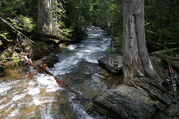 West Fork Fish Creek, proposed Great Burn Wilderness Area, Montana. 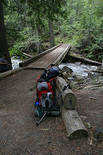 Creek crossing along the West Fork Fish Creek, proposed Great Burn Wilderness Area, Montana. 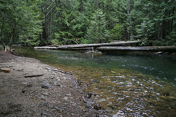 Swimming/fishing hole along the West Fork Fish Creek, proposed Great Burn Wilderness Area, Montana. 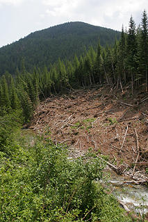 Avalanche debris, along the West Fork Fish Creek, proposed Great Burn Wilderness Area, Montana. 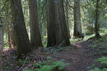 Connor along one of the many old growth cedar groves of the West Fork Fish Creek, proposed Great Burn Wilderness Area, Montana. 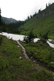 Ascending out of the Foley Basin, toward the Siamese Lakes, proposed Great Burn Wilderness Area, Montana. 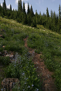 Ascending out of the Foley Basin, toward the Siamese Lakes, proposed Great Burn Wilderness Area, Montana. 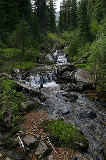 Unnamed creek along the trail to the Siamese Lakes, proposed Great Burn Wilderness Area, Montana. 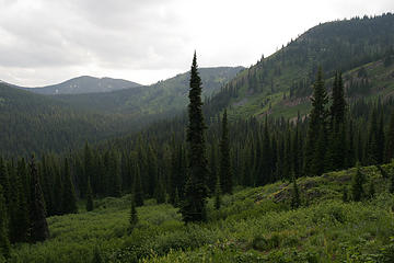 Looking into the Foley Basin of the West Fork Fish Creek, proposed Great Burn Wilderness Area, Montana. 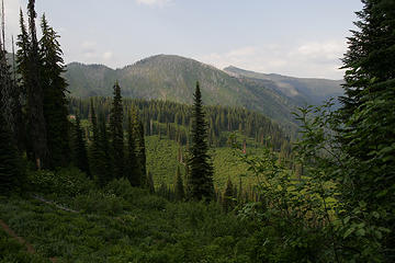 West Fork Fish Creek, proposed Great Burn Wilderness Area, Montana. 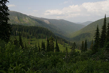 West Fork Fish Creek, proposed Great Burn Wilderness Area, Montana. 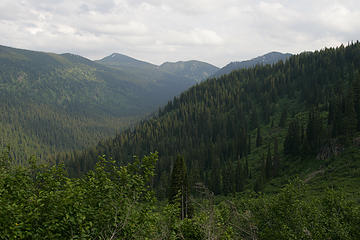 Looking into the Foley Basin of the West Fork Fish Creek, proposed Great Burn Wilderness Area, Montana. 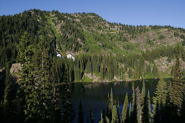 Lower Siamese Lake, proposed Great Burn Wilderness, Bitterroot Divide, Montana. 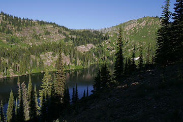 Lower Siamese Lake, proposed Great Burn Wilderness, Bitterroot Divide, Montana. 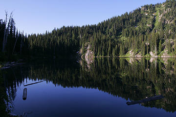 Lower Siamese Lake, proposed Great Burn Wilderness, Bitterroot Divide, Montana. 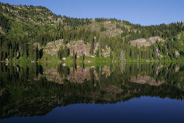 Lower Siamese Lake, proposed Great Burn Wilderness, Bitterroot Divide, Montana. 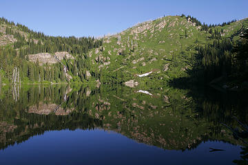 Lower Siamese Lake, proposed Great Burn Wilderness, Bitterroot Divide, Montana. 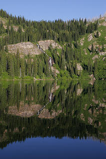 Lower Siamese Lake, proposed Great Burn Wilderness, Bitterroot Divide, Montana. 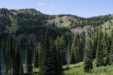 Lower Siamese Lake, proposed Great Burn Wilderness Area, Bitterroot Divide, Montana. 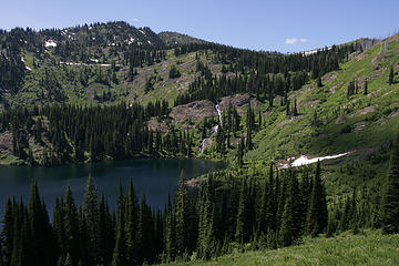 Lower Siamese Lake, proposed Great Burn Wilderness Area, Bitterroot Divide, Montana. 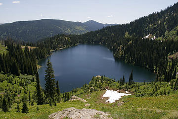 Lower Siamese Lake, proposed Great Burn Wilderness Area, Bitterroot Divide, Montana. 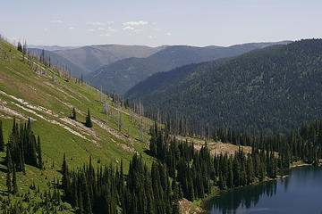 Lower Siamese Lake, proposed Great Burn Wilderness Area, Bitterroot Divide, Montana. 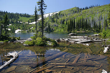 Upper Siamese Lake, proposed Great Burn Wilderness Area, Bitterroot Divide, Montana. 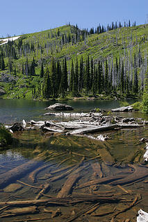 Upper Siamese Lake, proposed Great Burn Wilderness Area, Bitterroot Divide, Montana. 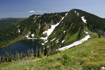 Upper Siamese Lake from near the ridge, proposed Great Burn Wilderness, Bitterroot Divide, Montana. 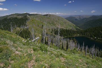 Upper Siamese Lake from near the ridge, proposed Great Burn Wilderness, Bitterroot Divide, Montana. 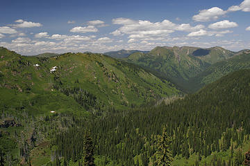 The Straight Creek drainage from near our high point along the Bitterroot Divide between Idaho and Montana. 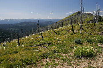 Looking north along the Bitterroot Divide between Idaho and Montana.  The state line along the Bitterroot Divide between Idaho and Montana. 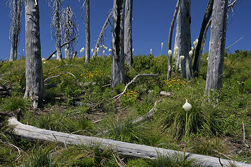 Silver snags along the Bitterroot Divide between Idaho and Montana. 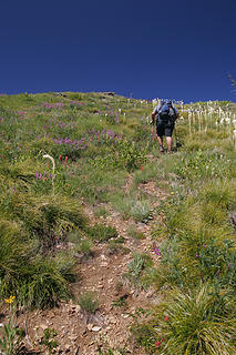 Connor ascends the steep trail to our high point along the Bitterroot Divide between Idaho and Montana. 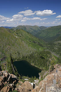 Straight Lake and the Straight Creek drainage from our high point along the Bitterroot Divide between Idaho and Montana. 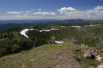 Looking north along the Bitterroot Divide between Idaho and Montana. 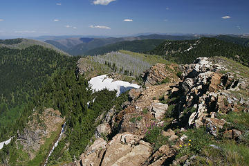 The ridge acended along trail #738 along the Bitterroot Divide between Idaho and Montana. 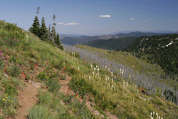 Trail #738 along the Bitterroot Divide between Idaho and Montana. 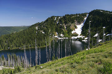 Upper Siamese Lake from the ridge, proposed Great Burn Wilderness, Bitterroot Divide, Montana. 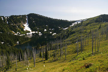 Upper Siamese Lake from the ridge, proposed Great Burn Wilderness, Bitterroot Divide, Montana. 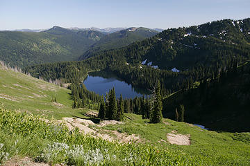 Lower Siamese Lake from the ridge, proposed Great Burn Wilderness, Bitterroot Divide, Montana. 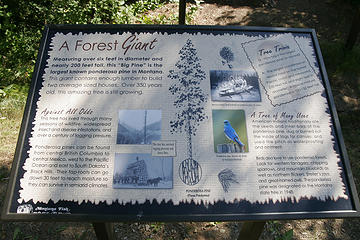 Largest ponderosa pine in all of Montana. 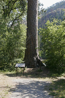 Largest ponderosa pine in all of Montana. 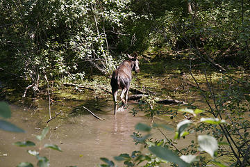 Moose near trailhead, Bitterroot Mountains, Montana. 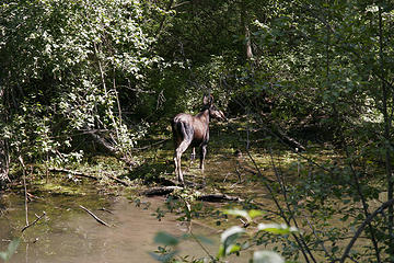 Moose near trailhead, Bitterroot Mountains, Montana.
|
| Back to top |
  
|
|
drilldaddyo
Member

Joined: 28 Feb 2008
Posts: 69 | TRs | Pics
Location: Spokane, Washington |
Awsome report! Thanks!
Randy
|
| Back to top |
|
|
harrymalamute
Member

Joined: 26 Apr 2008
Posts: 852 | TRs | Pics
Location: Spokane |
i am so jealous.i've been eyeballin this one for awhile. when cole indicated you were on a 30miler some how my subconscious thought of this trip.must be like my father often tells me,"brilliant minds think alike".
hikes and climbs with malamute
hikes and climbs with malamute
|
| Back to top |
|
|
Movenhike
\m/..mmmmetal\m/
Joined: 16 Apr 2007
Posts: 642 | TRs | Pics
Location: Leavenworth, WA |
|
Movenhike
\m/..mmmmetal\m/
|
Thu Jul 31, 2008 5:06 pm |
|
|
That's really cool.
I drove over Lolo Pass and down the Lochsa yesterday and wondered what the high country in that area was like.
Those pics of Foley Basin and the upper lake are great.
"Make it your Friend" -John Bull
"Make it your Friend" -John Bull
|
| Back to top |
|
|
Malachai Constant
Member

Joined: 13 Jan 2002
Posts: 16092 | TRs | Pics
Location: Back Again Like A Bad Penny |
I have been interested n that area ever since reading Lewis and Clark's journals 
"You do not laugh when you look at the mountains, or when you look at the sea." Lafcadio Hearn
"You do not laugh when you look at the mountains, or when you look at the sea." Lafcadio Hearn
|
| Back to top |
|
|
|
|
You cannot post new topics in this forum
You cannot reply to topics in this forum
You cannot edit your posts in this forum
You cannot delete your posts in this forum
You cannot vote in polls in this forum
|
Disclosure: As an Amazon Associate NWHikers.net earns from qualifying purchases when you use our link(s). |


