| Previous :: Next Topic |
| Author |
Message |
Tim Hagan
Member


Joined: 22 Jul 2008
Posts: 189 | TRs | Pics
Location: Bellevue, WA |
My brother and I completed a 4-day loop up the Whitepine Creek and Wildhorse Creek trails to Lake Grace and Frosty Pass, then over to Doelle Lakes and back down Whitepine Creek.
Day 1 was a long but easy jaunt up the Whitepine Creek and Wildhorse Creek trails (east of Stevens Pass). The latter was a bit brushy in places but otherwise in pretty good shape as far as the Lake Grace turnoff. However, it did have too many downhill stretches for our liking. The trail to Lake Grace was also in fine shape and included a short but delightful section paved with dried mud. After we had set up camp my brother remarked how nice it was to have the whole place to ourselves. Five seconds later, the first of another party of three appeared over the ridge.
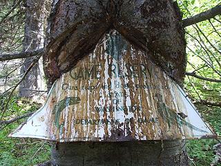 Sap-covered Game Reserve sign on Wildhorse Creek trail. It reads: "Game Reserve / Guns, traps and dogs prohibited / State of Washington / Department of Game". 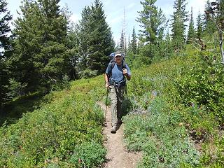 On the Wildhorse trail. 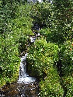 The trail forks just beyond this little waterfall. The left fork climbs to Deadhorse Pass -- avoid it unless you REALLY want to go there. 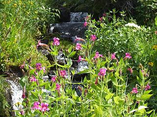 Lewis's Monkeyflower. 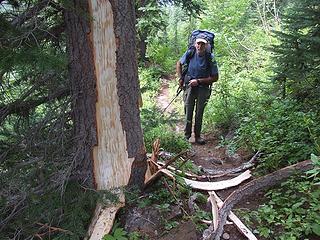 Ripped up tree on the Wildhorse trail. 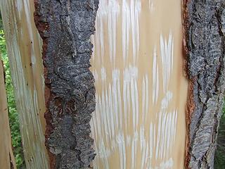 Porcupine activity? They look like teeth marks. 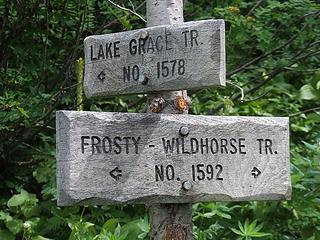 We had heard that the Lake Grace trail was very difficult to find. Fortunately, this sign pointed us in the right direction. 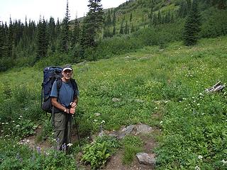 At the Lake Grace trail junction. 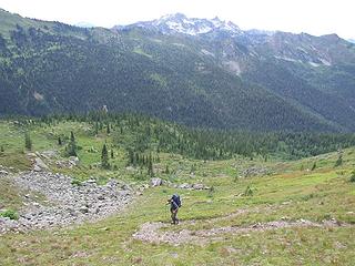 On the Lake Grace trail -- pretty much an uphill grunt at this point. 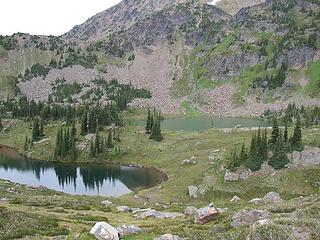 Lake Grace (there's actually two of 'em, not including Upper Grace Lake). 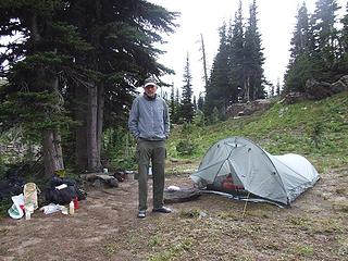 Camp at Lake Grace. 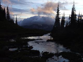 Dusk from Lake Grace outlet stream. 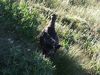 Grouse on Frosty Pass trail. 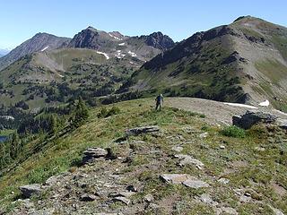 On Point 7052 SW of Mary Pass. 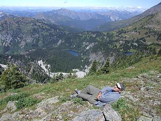 Lazy-boy. 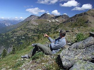 Relaxing (Part 1). 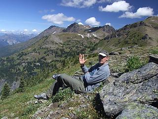 Relaxing (Part 2). 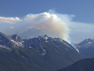 Jack Creek fire ten miles to the south obscuring Mt Stuart. 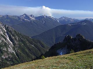 Jack Creek fire. 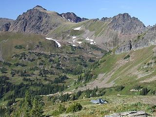 Snowgrass Mountain from Point 7052. 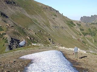 Our water supply. 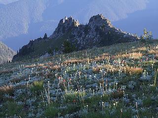 Wildflowers and spires at dusk. 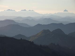 Hazy waves. 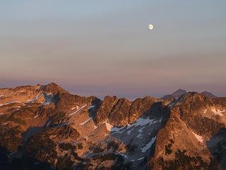 Moonrise over Grindstone Mountain. 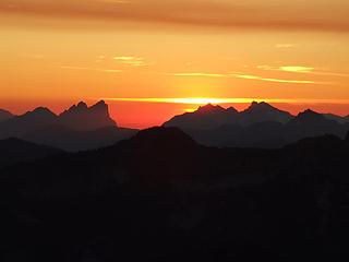 Mt Baring at sunset. 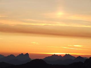 Sunset sundog. 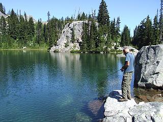 Fishing for lunkers at lower Doelle Lake. 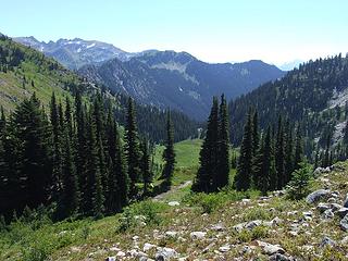 The view SE from Point 5800 NE of Doelle Lakes. 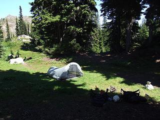 Our mosquito-infested camp at lower Doelle Lake. 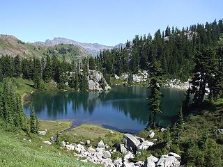 Lower Dolle Lake. 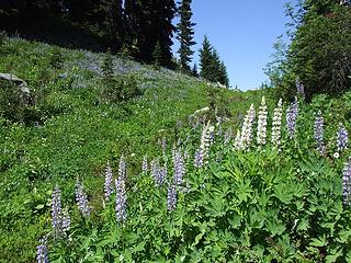 Lupines at upper Doelle Lake. 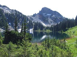 Upper Doelle Lake. 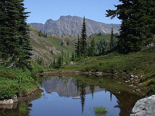 Pond reflection above upper Doelle Lake. 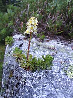 Lone Partridgefoot at lower Doelle Lake. 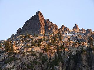 Bull's Tooth at dusk. 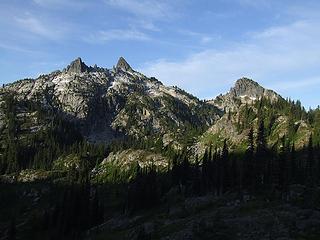 Bull's Tooth (Teeth?). 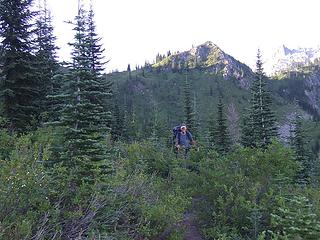 On the Mule Creek trail before we lost it. 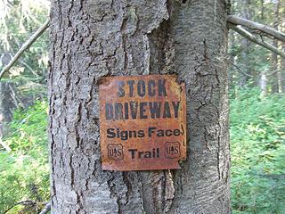 Stock Driveway sign near the junction of Mule Creek and Whitepine Creek. 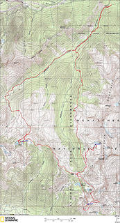 Doelle Lakes Loop GPS Track (ignore the long straight-line segment near the bottom)
|
| Back to top |
  
|
|
Backpacker Joe
Blind Hiker

Joined: 16 Dec 2001
Posts: 23956 | TRs | Pics
Location: Cle Elum |
Great pics and report. Did you think of getting up to Upper Grace Lake?
"If destruction be our lot we must ourselves be its author and finisher. As a nation of freemen we must live through all time or die by suicide."
Abraham Lincoln
"If destruction be our lot we must ourselves be its author and finisher. As a nation of freemen we must live through all time or die by suicide."
Abraham Lincoln
|
| Back to top |
|
|
Slide Alder Slayer
Member

Joined: 14 Jan 2002
Posts: 1960 | TRs | Pics
|
Great trail report and pictures! Glad to see those were not hand gang signs and that you were smoking a cigar!
|
| Back to top |
|
|
Get Out and Go
Member

Joined: 13 Nov 2004
Posts: 2128 | TRs | Pics
Location: Leavenworth |
I've taken a look at Whitepine beyond the Wildhorse junction.  I think that it's been abandoned for years now. Good job of pioneering down Mule and out. And nice campsite off of Mary's Pass. I think that it's been abandoned for years now. Good job of pioneering down Mule and out. And nice campsite off of Mary's Pass. 
"These are the places you will find me hiding'...These are the places I will always go."
(Down in the Valley by The Head and The Heart)
"Sometimes you're happy. Sometimes you cry.
Half of me is ocean. Half of me is sky."
(Thanks, Tom Petty)
"These are the places you will find me hiding'...These are the places I will always go."
(Down in the Valley by The Head and The Heart)
"Sometimes you're happy. Sometimes you cry.
Half of me is ocean. Half of me is sky."
(Thanks, Tom Petty)
|
| Back to top |
|
|
Tim Hagan
Member
Joined: 22 Jul 2008
Posts: 189 | TRs | Pics
Location: Bellevue, WA |
| Backpacker Joe wrote: | | Great pics and report. Did you think of getting up to Upper Grace Lake? |
Thanks. Yes, we thought about going to Upper Grace Lake until we saw the route. Or, rather, lack of route. The slope leading to the upper lake is pretty steep, with lots of cliff bands. We saw a couple of possible routes but it didn't seem like it was worth the effort.
|
| Back to top |
|
|
Backpacker Joe
Blind Hiker
Joined: 16 Dec 2001
Posts: 23956 | TRs | Pics
Location: Cle Elum |
How about a picture of that amazing tree! 
"If destruction be our lot we must ourselves be its author and finisher. As a nation of freemen we must live through all time or die by suicide."
Abraham Lincoln
"If destruction be our lot we must ourselves be its author and finisher. As a nation of freemen we must live through all time or die by suicide."
Abraham Lincoln
|
| Back to top |
|
|
Tim Hagan
Member
Joined: 22 Jul 2008
Posts: 189 | TRs | Pics
Location: Bellevue, WA |
| Backpacker Joe wrote: | | How about a picture of that amazing tree! |
After surviving the Whitepine Creek "trail", I didn't feel like juggling batteries around to get my camera working again. All I could think about was the beer waiting back at the car. You'll just have to go see that tree for yourself!
|
| Back to top |
|
|
mdm
Member
Joined: 13 Apr 2007
Posts: 16 | TRs | Pics
|
|
mdm
Member
|
 Mon Aug 18, 2008 11:56 am |
|
|
I can't tell for sure, but I think you guys made a mistake dropping down to Mule Crk where you did. You should have kept contouring. There is a trail that we came across last year, after bushwacking out of the White Pine Crk valley. It traverses the east side of the basin and enters the trees at around the 4800 ft contour as it decends to White Pine Crk. We didn't see for sure the condition further down, as we came from Josephine Lake. But when we popped out of the brush at about treeline there was a bow hunting couple calling for us that the trail was right here - I'm sure they had heard my cursing from 1000 ft away. The trail they were sitting on was in very fine shape, and they indicated that it was fine all the way down to the valley. I can't believe it could peter out too quick, since it was in such good shape there and the couple were obviously not big hikers. I remember the section of White Pine Crk trail where you joined, and it's pretty much like that all the way up to the saddle above Icicle Crk. How far down before the trail improves?
|
| Back to top |
|
|
Conrad
Meadow bagger

Joined: 25 Aug 2006
Posts: 2298 | TRs | Pics
Location: Moscow, ID |
|
Conrad
Meadow bagger
|
Mon Aug 18, 2008 2:01 pm |
|
|
We just hiked the Doelle-Frosty section the opposite direction from you, W to E. We totally lost the trail in a little meadow basin 1 crow-mile NW of Frosty Pass, where it then (on my GT map) contours SSE across a steep brushy slope. We ended up having to drop off-trail to another basin at 5600' and then climb back up to refind the trail closer to Frosty Pass.
I'd be curious to know if the trail disappears (apparently not by your not mentioning it) at the same point if you're heading NW, or if it's easy to stay on going that way.
|
| Back to top |
|
|
Tim Hagan
Member
Joined: 22 Jul 2008
Posts: 189 | TRs | Pics
Location: Bellevue, WA |
| Conrad wrote: | | I'd be curious to know if the trail disappears (apparently not by your not mentioning it) at the same point if you're heading NW, or if it's easy to stay on going that way. |
We lost the trail twice while hiking from Frosty Pass to Doelle Lakes but quickly picked it up again with a little searching. The first time was 1 mile NW of Frosty Pass where a side trail led us astray in a little flat meadow (sounds like the same place you lost it). The second time was in the large marsh just east of Doelle Lakes.
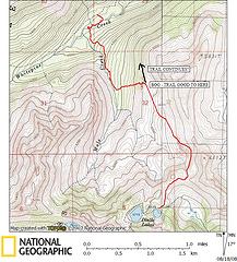
Here's a larger map of my GPS track from Frosty Pass to Doelle Lakes. It pretty much matches what's shown on the Green Trails map.
 Frosty-Doelle Trail GPS Track
|
| Back to top |
|
|
Tim Hagan
Member
Joined: 22 Jul 2008
Posts: 189 | TRs | Pics
Location: Bellevue, WA |
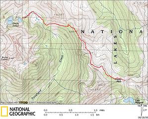
mdm - We lost the trail in a huge bog at 4800 ft and couldn't figure out where it continued in the brush on the other side. There was a steep-sided stream beyond the brush (to the N) which was also very brushy, so we descended fairly open slopes south of the stream towards Mule Creek instead.
Here's my GPS track of that portion of the route:
 GPS track
|
| Back to top |
|
|
Conrad
Meadow bagger
Joined: 25 Aug 2006
Posts: 2298 | TRs | Pics
Location: Moscow, ID |
|
Conrad
Meadow bagger
|
Mon Aug 18, 2008 4:47 pm |
|
|
| Tim Hagan wrote: | | The first time was 1 mile NW of Frosty Pass where a side trail led us astray in a little flat meadow |
Thanks for the map!
Now I'm guessing we were already off on the side trail, down in the flat of Little Flat Meadow, when I started questioning where the real trail was, and if I'd retraced further NW I might have found the right trail, contouring SW higher up the slope.
|
| Back to top |
|
|
|
|


