| Previous :: Next Topic |
| Author |
Message |
bdrkayaker
Member


Joined: 17 Oct 2009
Posts: 61 | TRs | Pics
|
Never posted a report here, but love the site for its wealth of info and amazing pictures and adventures.
I've been wanting to hike up Big Snow for some time, after seeing it from Snoqualmie Mountain. It's relative remoteness (=solitude) with the gating of the middle fork road was a huge lure, as were the beautiful pics of old trip reports.
Nitobe and I got a 7:30 start from the gate at the Taylor River, biking up the road in cool weather. We each had full suspension mountain bikes which, while not necessary, definitely made the ride more pleasant. We took a little less then three hours to make it up to the Hardscrabble trail parking area (large pullout after the giant log on the side of the road). This time could have been reduced if we'd biked harder, but we took our time and stopped to check out the river in a few spots.
The trail to Lower Hardscrabble is returning to nature. We saw some fresh boot prints in the mud so it is clear that people make it up there, but the trail is seriously overgrown with alder at the beginning. Cairns assist in staying on track through the early talus field but the way is pretty obvious.
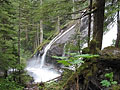
We arrived at the Lower Lake with pretty heavy cloud cover, traversed left on the west side of the lake through nonstop pika chirps, and had a snack at the inflow while looking up at the impressive east buttress of Big Snow. We ended up making the mistake of heading up to the Upper Lake on the right side of the inflow waterfall. After bashing and schwacking up a steep slope, we crossed the stream and continues on a well defined trail to the upper lake. ***Passed two very large fresh bear prints in the mud!!***
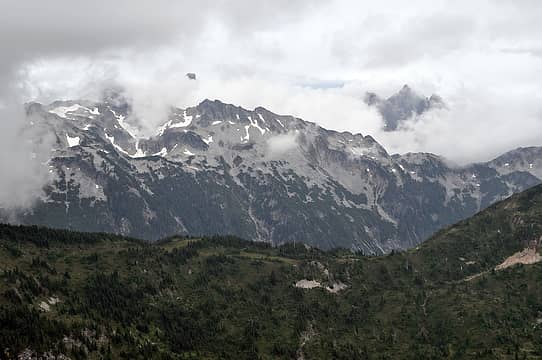
From the upper lake, we headed around on the west side, up the inflow, and through talus and scrubby trees to below two obvious gullies. We dropped a pack, climbed the left gulley, and proceeded to climb more talus up to the pass where we got some nice views of the lakes to the north (Gold, Dorothy, etc). Unfortunately, the clouds had descended and we couldn't see much in terms of other peaks.
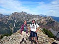
We headed up the football field and had a great time climbing through fun rocks up to the summit, with only one small snow patch at the base of the summit that we could have avoided if we'd wanted to.
The summit was pretty clouded in, but still a great place to relax. There are soooo many flat and beautiful places to bivy up around the plateaus surrounding the summit! Can't wait to return in nicer weather. The register (in an old water bottle) has one page left. Last entry August 1, 2009.
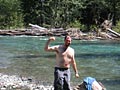
Headed back down from the summit just before 4pm and were back at the bikes at 7. The ride down was fast and fun (again full suspension helped here), and after stopping for a refreshing splash in the river we were back at the car at 8:30 with the very last of the light.
Super fun trip! I can't wait to see that place on a clear sunny day. One day was too short - I'd love to loop some of the lakes we saw and enjoy that area more thoroughly (especially Big Snow Lake).
Although it is tempting to say the trip was no big deal, I was wupped by the end of ride out!
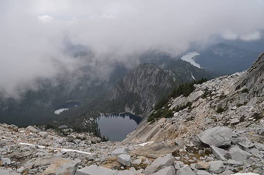 Big Snow Lake, Snowflake Lake, Myrtle Lake, and Lake Dorothy 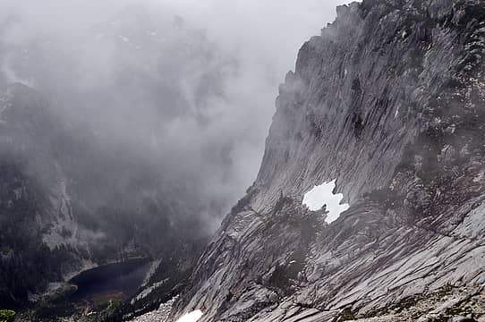 Lower Hardscrabble Lake and East Buttress of Big Snow 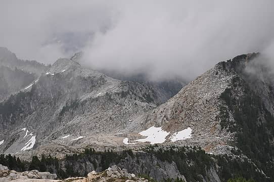 View back to the football field and pass 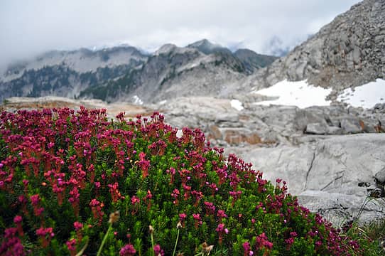 The heather was in full bloom 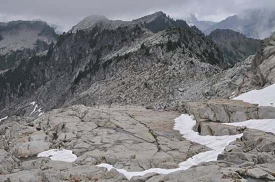 The football field with peaks in the distance starting to emerge 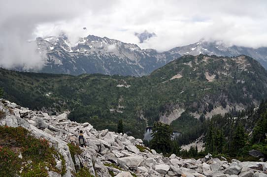 Nitobe heading back down to Upper Hardscrabble Lake with Overcoat and Lemah peaks shrouded by clouds. 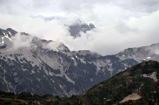 The Misty Mountains
Nothing in the world is more yielding and gentle than water. Yet it has no equal for conquering the resistant and tough. The flexible can overcome the unbending; the soft can overcome the hard. - Lao Tse
Nothing in the world is more yielding and gentle than water. Yet it has no equal for conquering the resistant and tough. The flexible can overcome the unbending; the soft can overcome the hard. - Lao Tse
|
| Back to top |
  
|
|
D. Inscho
Not bored yet...

Joined: 28 Feb 2010
Posts: 973 | TRs | Pics
Location: Bellingham,WA |
|
D. Inscho
Not bored yet...
|
 Sun Aug 22, 2010 4:16 pm |
|
|
Great post from a beautiful area!
I had to laugh at your miscue going from lower to upper Hardscrabble; I did that same brush-bash my first time up there to camp at the ridgeline tarn, found the trail on the way back down. The ridgeline meadows are fabulously cozy & scenic, worth going back for a stay...
http://david-inscho.smugmug.com/
The key to a successful trip is to do the planning during work hours. -- John Muir
My most memorable hikes can be classified as 'Shortcuts that Backfired'. --Ed Abbey
http://david-inscho.smugmug.com/
The key to a successful trip is to do the planning during work hours. -- John Muir
My most memorable hikes can be classified as 'Shortcuts that Backfired'. --Ed Abbey
|
| Back to top |
|
|
Tom
Admin
Joined: 15 Dec 2001
Posts: 17851 | TRs | Pics
|
|
Tom
Admin
|
Sun Aug 22, 2010 4:23 pm |
|
|
You must be in good shape to do all of that in a day! If you go in again I'd suggest Dingford to Big Snow Lake (via the outlet). Can't think of an easy way to loop out thanks to the Dingford gate, but at least you've seen Hardscrabble.
|
| Back to top |
|
|
naturealbeing
Member

Joined: 05 Dec 2004
Posts: 1565 | TRs | Pics
Location: Great Mystery |
Welcome to NWHikers! You sure know how to take advantage of the hours in a day. Glad you were able to get the job done, to bad about the clouds hiding your views.
From what I've been told, the Big Snow Quad has more peaks than any of the other quads in WA state.
Just to tease you to get back up there under better conditions.
 87 labels Panorama from Big Snow Mtn. 8.13.06.
|
| Back to top |
|
|
Dayhike Mike
Bad MFKer
Joined: 02 Mar 2003
Posts: 10958 | TRs | Pics
Location: Going to Tukwila |
Niiice! Thanks for the TR. Brings back lots of great memories...
Glad to hear the trail is still in reasonable shape, even if it's suffering a bit from disuse.
And welcome to the site! Here's to hoping you continue to post your adventures... 
"There is only one basic human right, the right to do as you damn well please. And with it comes the only basic human duty, the duty to take the consequences." -P.J. O'Rourke
"Ignorance is natural. Stupidity takes commitment." -Solomon Short
"There is only one basic human right, the right to do as you damn well please. And with it comes the only basic human duty, the duty to take the consequences." -P.J. O'Rourke
"Ignorance is natural. Stupidity takes commitment." -Solomon Short
|
| Back to top |
|
|
Backpacker Joe
Blind Hiker

Joined: 16 Dec 2001
Posts: 23956 | TRs | Pics
Location: Cle Elum |
Yes welcome. Great work.
"If destruction be our lot we must ourselves be its author and finisher. As a nation of freemen we must live through all time or die by suicide."
Abraham Lincoln
"If destruction be our lot we must ourselves be its author and finisher. As a nation of freemen we must live through all time or die by suicide."
Abraham Lincoln
|
| Back to top |
|
|
bdrkayaker
Member
Joined: 17 Oct 2009
Posts: 61 | TRs | Pics
|
Thanks everyone for the kind words!
That is an amazing pano. We saw it in the register bottle, and thought it was a cool thing to include.
D. Inscho, do you mean the ridge above and east of the upper Lake? We thought that ridge looked really neat - the trees looked very striking scattered among those meadows.
 USMM2 ridge between upper Hardscrabble Lake and the Middle Fork valley
Nothing in the world is more yielding and gentle than water. Yet it has no equal for conquering the resistant and tough. The flexible can overcome the unbending; the soft can overcome the hard. - Lao Tse
Nothing in the world is more yielding and gentle than water. Yet it has no equal for conquering the resistant and tough. The flexible can overcome the unbending; the soft can overcome the hard. - Lao Tse
|
| Back to top |
|
|
Tom
Admin
Joined: 15 Dec 2001
Posts: 17851 | TRs | Pics
|
|
Tom
Admin
|
Mon Aug 23, 2010 11:27 am |
|
|
You could loop out the Foss or Camp Robber Valley. Problem is the car shuttle unless someone will be dropping you off and picking you up. Also, not sure how you would retrieve your bikes from Dingford. A dropoff would make more sense once you can drive to Dingford.
|
| Back to top |
|
|
DIYSteve
seeking hygge

Joined: 06 Mar 2007
Posts: 12655 | TRs | Pics
Location: here now |
|
DIYSteve
seeking hygge
|
Mon Aug 23, 2010 11:52 am |
|
|
Nice Brings back memories years ago
|
| Back to top |
|
|
ChinookPass
Member

Joined: 21 Aug 2009
Posts: 145 | TRs | Pics
|
Studs!
I tried that route a few years ago and couldn't find any route through the alder from the "parking" area.
Any clues?
In any case, the Dingford side is nice except for some bushwacking right above Myrtle and a little sketchiness to get around the outlet waterfall.
|
| Back to top |
|
|
bdrkayaker
Member
Joined: 17 Oct 2009
Posts: 61 | TRs | Pics
|
| Tom wrote: | | You could loop out the Foss or Camp Robber Valley. Problem is the car shuttle unless someone will be dropping you off and picking you up. Also, not sure how you would retrieve your bikes from Dingford. A dropoff would make more sense once you can drive to Dingford. |
Yeah, the looping with bikes thing is tough to figure out. We were kind of shocked by how many vehicles we saw behind the gates. A bunch of trucks/jeeps were running their engines while we geared up and started biking at the Taylor gate - they passed us (all single drivers it seemed like) before Dingford. Then a couple of trucks parked at Dingford, and more further back. Lots of Oregon license plates  Hitching up and/or back shouldn't be too hard!
I should have taken pics of the parking area, trail etc. From the large parking area ~50 yards uphill from the decaying huge log there is a faint trail cutting diagonally in the dirt uphill to the right. Brush bashing starts immediately. A overgrown logging road heads diagonally left...the trail eventually meets up with the road further uphill in the woods. Hitching up and/or back shouldn't be too hard!
I should have taken pics of the parking area, trail etc. From the large parking area ~50 yards uphill from the decaying huge log there is a faint trail cutting diagonally in the dirt uphill to the right. Brush bashing starts immediately. A overgrown logging road heads diagonally left...the trail eventually meets up with the road further uphill in the woods.
Nothing in the world is more yielding and gentle than water. Yet it has no equal for conquering the resistant and tough. The flexible can overcome the unbending; the soft can overcome the hard. - Lao Tse
Nothing in the world is more yielding and gentle than water. Yet it has no equal for conquering the resistant and tough. The flexible can overcome the unbending; the soft can overcome the hard. - Lao Tse
|
| Back to top |
|
|
Sabahsboy
Member

Joined: 18 Jul 2006
Posts: 2484 | TRs | Pics
Location: SW Sno County |
Photo view of Lower Hardscrabble Lake with East Buttress is truly alpine and frightening, spectacular! Just the scene I love! Thrilling! Thank you for photos, fascinating TR and contributing to reports.
|
| Back to top |
|
|
DIYSteve
seeking hygge
Joined: 06 Mar 2007
Posts: 12655 | TRs | Pics
Location: here now |
|
DIYSteve
seeking hygge
|
Mon Aug 23, 2010 4:48 pm |
|
|
| bdrkayaker wrote: | | A overgrown logging road heads diagonally left...the trail eventually meets up with the road further uphill in the woods. |
It's been 17 years since I last did the route, so a grain of salt is in order, but I recall going up the old roadbed, then working to the lower lake with little or no boot tread. I also seem to recall staying climber's left of the outlet stream on the way to the upper lake.
|
| Back to top |
|
|
Malachai Constant
Member

Joined: 13 Jan 2002
Posts: 16092 | TRs | Pics
Location: Back Again Like A Bad Penny |
Last time I was there was on Eds final trip. Then the trail was clearer than it had been in the 90's but still subtle. It started on an abandoned road with encroaching Alders then traversed to the lower lake. The trail went around the lake to the inlet but headed up quite a bit to the left of the inlet through small trees and heavy brush. There were several campsites at the upper lake. The route above the lake was indefinite and braided. There was considerable talus to the ridge. It is easy to drop down to Gold Lake and you can continue to Chetwoot on game trails. I assume it will pretty much revert to nature now. 
"You do not laugh when you look at the mountains, or when you look at the sea." Lafcadio Hearn
"You do not laugh when you look at the mountains, or when you look at the sea." Lafcadio Hearn
|
| Back to top |
|
|
Dayhike Mike
Bad MFKer
Joined: 02 Mar 2003
Posts: 10958 | TRs | Pics
Location: Going to Tukwila |
| bdrkayaker wrote: | | Hitching up and/or back shouldn't be too hard! |
I can vouch for this.
When Ed and I made a loop of it, we went in via Dingford and came out via the Hardscrabbles. Flagged down a miner 30 seconds after breaking out onto the road and got an easy lift back to our rig at Dingford.
"There is only one basic human right, the right to do as you damn well please. And with it comes the only basic human duty, the duty to take the consequences." -P.J. O'Rourke
"Ignorance is natural. Stupidity takes commitment." -Solomon Short
"There is only one basic human right, the right to do as you damn well please. And with it comes the only basic human duty, the duty to take the consequences." -P.J. O'Rourke
"Ignorance is natural. Stupidity takes commitment." -Solomon Short
|
| Back to top |
|
|
|
|


