| Previous :: Next Topic |
| Author |
Message |
Tom_Sjolseth
Born Yesterday


Joined: 30 May 2007
Posts: 2651 | TRs | Pics
Location: Right here. |
I hiked up Big Chiwaukum on Labor Day with my Dad.
We left the car at the Whitepine TH at 9:20AM, after a "leisurely" meet time of 6AM in Seattle.
The trail gains 2,750' in 6 miles. Take the Wildhorse Creek Junction about 2.25 miles up. At ~6 miles, below a good vantage point of Chiwaukum's NW Ridge, we ascended cross-country through beautiful heather slopes then rock bands (Class 3). We could see that about 500' below the summit, the trees and rock were plastered in brilliant white rhime ice. It got cold fast these last few hundred feet, as the wind picked up and the clouds swirled by. The rock was totally glazed on the summit block, making routefinding tricky.. we were looking for the absolute easiest route.
After some searching, we came up with a class 3 option that avoided most of the steeper angled rock. A solid gulley brought us onto the summit, one of many in the conglomerate of summits that makes up Big Chiwaukum. The summit register (packed in an old aluminum tee), dates back to 1973. It's in so-so shape, with some pages hard to read. Notable recent ascentionists include Dick Kegel (Kangaroo, an original Bulger) on July 4, and our own Stefan Feller, only a week prior.
The views from the summit were surprisingly good, at least the ones we caught a glimpse of between the swirling clouds. It got extremely cold on the summit, and we saw whisps of snow, but nothing materialized. The rhime ice wasn't going anywhere anytime soon, it seemed. We headed down amongst increasing winds, and quickly got back down to the trail where it was warm once again. After rehydrating, we began the 6 mile trudge back to the car.
The trip out was uneventful. We only saw one party the whole day. We saw a bear in a basin NNW of Chiwaukum eating huckleberries (which are now ripe). Unfortunately we didn't bring a camera.
Round-Trip Stats:
-15 miles
-5900' gain
-8.5 hours
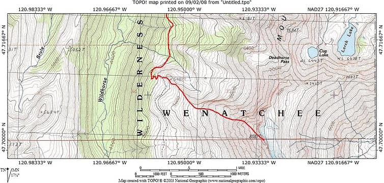 Route up NW Ridge of Big Chiwaukum
|
| Back to top |
  
|
|
Movenhike
\m/..mmmmetal\m/
Joined: 16 Apr 2007
Posts: 642 | TRs | Pics
Location: Leavenworth, WA |
|
Movenhike
\m/..mmmmetal\m/
|
 Tue Sep 02, 2008 5:26 pm |
|
|
 Good info, thanx Good info, thanx
"Make it your Friend" -John Bull
"Make it your Friend" -John Bull
|
| Back to top |
|
|
wildernessed
viewbagger

Joined: 31 Oct 2004
Posts: 9275 | TRs | Pics
Location: Wenatchee |
Nice Tom, I was looking at that and Snowgrass as a fall thru trip, in Whitepine, out Chatter Creek or other. (not a dayhike though)
Living in the Anthropocene
Living in the Anthropocene
|
| Back to top |
|
|
Stefan
Member

Joined: 17 Dec 2001
Posts: 5095 | TRs | Pics
|
|
Stefan
Member
|
Tue Sep 02, 2008 5:36 pm |
|
|
Hey, how was the dreaded highway 2 on the return on Labor day?
Our return through Everett and the standard backup did NOT materialize becuase of the added lanes! Wahoo!
|
| Back to top |
|
|
Tom_Sjolseth
Born Yesterday
Joined: 30 May 2007
Posts: 2651 | TRs | Pics
Location: Right here. |
Highway 2.. was a BREEZE! Where was the traffic? We were expecting a million motorhomes and trailers, but seriously it was wide open at 6:30PM!
Nice work on Storm King. Is the glass bottle still up there? When I was up there, it looked like this:
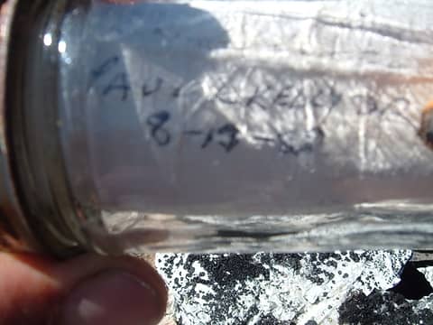 Storm King's glass bottle register. 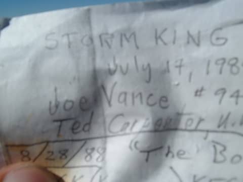 Joe Vance and Ted Carpenter's entry in Storm King's register.
|
| Back to top |
|
|
GeoTom
Member
Joined: 19 May 2005
Posts: 3216 | TRs | Pics
Location: Earth |
|
GeoTom
Member
|
Tue Sep 02, 2008 5:52 pm |
|
|
| Tom_Sjolseth wrote: | | Unfortunately we didn't bring a camera. |
Then I will not post a reply.
What? Damn. Ok, nice job 
|
| Back to top |
|
|
Backpacker Joe
Blind Hiker

Joined: 16 Dec 2001
Posts: 23956 | TRs | Pics
Location: Cle Elum |
Hey bubba, where's the pics of upper Grace lake and Charles lake?
Come on...... 
"If destruction be our lot we must ourselves be its author and finisher. As a nation of freemen we must live through all time or die by suicide."
Abraham Lincoln
"If destruction be our lot we must ourselves be its author and finisher. As a nation of freemen we must live through all time or die by suicide."
Abraham Lincoln
|
| Back to top |
|
|
Eric
Peak Geek

Joined: 21 Oct 2002
Posts: 2062 | TRs | Pics
Location: In Travel Status |
|
Eric
Peak Geek
|
Tue Sep 02, 2008 10:07 pm |
|
|
Thanks for the TR and especially the route map.
I'm curious, based on the route map it looks like you went to just the 8081T rather than the 8080+. Did you feel that 8081 looked to be the true HP? The reason I ask is because my recollection is that Paul K said the 8080+ was higher than 8081, but I could be remembering incorrectly. Any insight?
Big C is high on my wishlist since it is #27 on the WA prom list.
|
| Back to top |
|
|
Stefan
Member
Joined: 17 Dec 2001
Posts: 5095 | TRs | Pics
|
|
Stefan
Member
|
Wed Sep 03, 2008 10:21 am |
|
|
| Tom_Sjolseth wrote: | | Highway 2.. was a BREEZE! Where was the traffic? We were expecting a million motorhomes and trailers, but seriously it was wide open at 6:30PM!
Nice work on Storm King. Is the glass bottle still up there? When I was up there, it looked like this: |
glass register was still there....but the paper was frozen inside due to wetness and coldness and so we did not want to unravel the paper becuase it would have torn it.
|
| Back to top |
|
|
Tom_Sjolseth
Born Yesterday
Joined: 30 May 2007
Posts: 2651 | TRs | Pics
Location: Right here. |
Eric,
We most definitely hit the true highpoint, but I'm not sure which one that is on the map. We could clearly see accross to the other highpoints on the ridge, and it was obvious we were on the highest one. It's like the second nubbin from the N. The map I drew was free hand, not from GPS coordinates or anything, so take it with a grain of salt.
|
| Back to top |
|
|
Eric
Peak Geek
Joined: 21 Oct 2002
Posts: 2062 | TRs | Pics
Location: In Travel Status |
|
Eric
Peak Geek
|
Wed Sep 03, 2008 9:12 pm |
|
|
OK, yeah that is what I figured but always good to get as much info beforehand as possible. I'll assume Klenke is right on the N summit being higher than the 8081 so that must be what you guys went over. Gracias for the route info and map.
|
| Back to top |
|
|
|
|


