Dates:09/06/08 - 09/07/08Crew:DayHike Mike, yukon222, entire Schmidt Altitude team (Babe, Row, Kief, Dude)Lakes (in order of visiting them): Slide, Enjar, Hamar, Snowking, Cyclone, 5442Summits: Snowking 7433'Total Elevation Gain:8248 feet
Earlier this summer dicey told us that we just had to climb Snowking this year and we set a date for September. Being the lake baggers that we are, when we looked at the area on a map we couldn't help but notice all the spots of blue surrounding the mountain. Yukon222 was on board to trying the more adventurous approach than the traditional Kindy Ridge route and when we called our lake bagger buddy, DayHike Mike, for some beta he changed his plans so he could come along as well. Thus, we had perfect foursome (+2K9) for the lake route to the mountain. The plan was to meet up with Yana, dicey, gabrielx, Lindsay, Ben, Chap plus another buddy around Cyclone Lake and then summit Snowking on Sunday together.
Day 1: The Lake Bagging Approach
We drove the ~20 miles up the Illabot Creek Road waiting to experience the washed out areas Mike promised were coming around each corner. They never materialized and we made it to the Slide Lake Trailhead in yukon's 12M.P.G. truck traveling over a road that any of our 25+M.P.G. cars could of handled . We made quick work up the 1 mile to Slide Lake even though we were a little discouraged by the intermittent showers that rained down on us. We even made jokes about the possibility of beating the other team to our designated rendezvous .
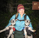
Everyone's ready to go
Slide Lake
After a brief stop at the lake shore we made our way over/under/around the numerous downed trees across the trail that follows the lake shore before passing an unoccupied tent at the inlet stream. This was the last we'd see of anything close to a maintained trail. We followed the boot path through head-high tall wet brush as we worked our way east along Otter Creek. We were quickly soaked to the core but the weather was just warm enough that we left off our rain gear. Half way along the 3+ miles to Enjar Lake the vegetation transitioned from brush to mature trees with sparse undergrowth meaning we could make better time. We arrived at Enjar to find some fishermen rafting in the middle of the lake. From our vantage point on the shore we planned our route up the unseen pass to the east of the Enjar Lake basin. After a brief rest, we traversed along the shore of Enjar and then bushwhacked through more wet brush over to Hamar Lake.
A little help from my friend
Enjar Lake
Bushwhacking around Hamar Lake
Hamar Lake
Next came the tricky part. We ascended up boulders from the east shore of Hamar and entered a creek gully filled with loose scree and dirt. We traveled up the gully towards the cliff bands high above us. We then left the gully and made an ascending traverse on a steep brush covered hillside to reach the base of the cliffs. We then traversed (NW) about 50' below the base of the cliffs looking for a route up through them. When we came to an impassible gully, we tried to climb up the mud covered channel in the middle to the top of the gully where it met the base of the cliffs. Yukon went first and made it, barely, but the mud and moss sloughed off the rocks beneath Babe's feet as she was about half way up . She slid down about 10 feet but luckily stopped just before Dude, who was below her, was about to try to jump to her rescue (probably injuring/killing both of them) . After we collected ourselves, we backtracked a little and then climbed up the duff to the base of the cliffs and crossed above the gully at the cliff base with Mike close behind. We found a way up through the cliffs not much farther on and then headed east up to the Snowking/Enjar Pass.
This weather sucks!
Enjar and Hamar Lakes
Up the boulders and through the brush to the cliff bands
Yukon and Babe take in the wonderful views of Snowking Mtn
Finally, views of Snowking!
At the pass the cloud cover lifted enough for us to see our first views of the Snowking summit. It was an impressive sight with the large glacier beneath it on the north face. We took a ton of pictures of it from different angles the rest of the day. We descended from the pass down to a small stand of mature trees below and found steep boot path that led us down to a huge basin north of Snowking Mountain. We crossed the basin first on boulders then on smaller rocks and finally reached a green meadow at the east side of the basin.
Snowking is out there somewhere
Hey, there really is a mountain out here
Down into the Snowking Basin
Snowking Basin
Walking on heather and moss is much better
The views of Snowking keep improving
Babe and Yukon below Snowking
In the meadows below Snowking
Can't take enough pictures of this impressive summit
From here the group split with Mike heading due towards the outlet stream of Cyclone Lake while the rest of us made a side trip down to Snowking Lake. We followed Snowking Glacier Creek downstream as it wound through the meadow and then descended steep, wet huckleberry covered slopes to the lake's shore. We spent about 20 minutes taking pictures and fishing. Because we were behind schedule we had to scrap our plans of visiting Skaro, Neori, and Found Lakes and went to catch up with Mike .
Snowking Creek running through the meadows
Snowking Mountain from the shores of Snowking Lake
Dude reels in another trout at Snowking Lake
We ascended straight up a boulder field of car sized boulders from the southern shore of Snowking Lake until we reached Mike waiting for us about 300' above the lake. Then, we travel east towards the outlet of Cyclone Lake and climbed up a small waterfall (class 3) to reach another boulder field that would lead us to the shore of Cyclone Lake. By the time we reached the lake the sun had set but our adventure was not over. It is impossible to travel around the lake along the shore so we had to find a route in the twilight through the rocks that surround the lake. There was one section of a class 4 move along a 3 inch ledge by the light of a headlamp but we eventually made it to hillside above the north shore of the lake where we could here loud voices laughing and carrying on. We turned off our headlamps and stalked towards the commotion. Of course, at the last moment the whippets ran ahead and spoiled our surprise but we were greeted by not only Yana and dicey, who we expected, but also Sadie's Driver, Opus, MiddleE, Snow Dog, and BPLlama (the rest of dicey's crew plus the NWHiker team silence were already in bed) . As we told our adventure to the gang Sadie's Driver offered to take us back to yukon's truck if we didn't want to do the cross-country route back out (we later suspected it was the Wild Tofurky talking). We then headed off to find camp spots by the shore of Lake 5442 and eat dinner. Of all the adventures we had this day, the craziest event might be the fact that Babe and the two whippets slept in the same bivy all night without suffocating !
Climbing up the boulder field of doom!
Cloudy Pickets from the Snowking Basin
Dude says goodbye to the fishies
Sidehill traverse towards Cyclone Lake
Day 1 Stats: 4547' gain, 1808' loss, 10:22
Full flickr set of approach day
Day 2: The Summit of the King of Snow
Word had been spread that we were all heading up at 7:00AM so we awoke before sunrise and prepared to summit. We rejoiced when we reached the hill above Cyclone Lake and basked in the sun . The clear blue skies in all directions promised a much warmer and dryer day than yesterday.
Snowking reflected in a tarn
Snowking and it's reflection
Rowena makes sure the route is clear of evil marmots and chipmunks
We ascended alternating granite slabs, heather benches, and small snow patches up the ridge that separates the Mutchler Creek Valley from the Cyclone Lake/Snowking Glacier Basin. Of course, the views became better and better the higher we rose and we were continually stopping to take pictures . Mutchler Peak (a.k.a. Snow Queen Mountain) was especially eye catching directly to the south.
The Ice Queen and the Snow Queen
Rowena and Mutchler Peak
Friction walking up the slabs
Cyclone Lake below and Eldorado in the distance
Yukon and mountains
Glacier Peak in the distance
Summit Dogs
A couple hundred feet below the final summit block we were forced to make a decision. While it was possible to travel all the way to the summit on dry boulders most of us chose to take a shortcut up a steep snowfield. Then, it was easy scrambling to the summit. We all made it about 2 hours after leaving camp.
MiddleE, Yukon, and Dude lead the way through the rocks
Sadie's Driver climbs Snowking (Mutchler and Glacier behind)
Here comes MiddleE
Just great, more boulders!
Snow Dog in the boulder section
The clear day meant we had spectacular views in all directions. To the northwest was Baker and Shuksan, north the Pickets, northeast Eldorado, southeast Glacier, southwest Chaval and farther on Whitehorse and Three Fingers, and we could even see a faint Rainier far to the south .
Mutchler and Buckindy from the summit
Rowena gets a taste of Glacier
SeKrit social summit shot
Baker and Shuksan from summit
Dicey climbing around on Stormking (Lakes Found, Neori, Skaro, Stormking, Cyclone, 5442 below)
It's Underdog!
Views south from the summit of Snowking
Views north from the summit of Snowking
Eventually we had to leave since the later starting Bens party of three and the silence couple were coming up. Since we already had 12 on the summit we wouldnt want to go over the party limit and make Tom mad now, would we ?!?
Glacier Peak
Dude bootskis with the whippets
Dude on the King of Snow
Ice Axe on the King of Snow (Mutchler and Glacier behind)
More glissading fun
What a motley crew
We probably took more pictures coming down than we did coming up. Thus, we were the last one back to camp. Sadies Driver still insisted shed take as many of us as she could fit back to yukons truck. So, after arranging rides for Dude and Mike with Opus, we decided to see how the Kindy Ridge route compared.
Dude and Eldorado
The boys check out some future summits
Mutchler Peak, Glacier, and Lake
Eldorado above our lake camp
Whippet friction downclimb
Yeah, we bad!
Stormking and Cyclone
Cyclone Lake reflections
Cyclone Lake
That reflective tarn in full daylight
While Kindy Ridge is no piece of cake, it is definitely a step or two easier than the route we took to the mountain and much faster. Dryer weather on the approach day would have made the experience much better but we still would have to recommend the Kindy Ridge route.
Backpacking again
Snowking Mountain and Lake
Kindy Ridge trailhead shot
Slide Lake trailhead shot
Mike looks for the truck while Opus drives away
Day 2 Stats:
Camp to Summit and back: 2694' gain, 2690 loss, 4:32
Camp to trailhead: 1007' gain, 5095' loss, 4:04
Full flickr set of summit day photos
We want to pass along a huge THANK YOU to Sadies Drive and Opus (plus their passengers) for giving us rides. You definitely dont need to bring any money to the next few socials, weve got you covered.
"Forest 101: These big wood stick things are called trees. The big rocks are called mountains, and the little rocks are their babies." Elliott from Open Season
0
"Forest 101: These big wood stick things are called trees. The big rocks are called mountains, and the little rocks are their babies." Elliott from Open Season
Moving thru wet brush, I held out hope the day would clear and I'd see Snowking as we approached it. Finally, it made a partial appearance late in the day! And the skies kept clearing so I went to sleep imagining crystal clear blue skies for the next morning. I wasn't disappointed.
I love it.
I kinda forgot about Snowking and Mutchler until I went up Hidden Lake Peaks the other weekend. Thanks for all the education. Anyone have a guess to the mileage on the Kindy Ridge route? Looks like the elevation is about 7700' on the way in and 1000' on the way out.
Lake bagging could become the addiction of the 2000's with pics like these.
I can just see the ads now:
Don't bake go hike to a lake
or
This is your knee on scree
Thanks for giving us this week's fix ~Jo
Yikes, approaching via Slide, Hamar, & Enjar is a tough way to get there.
But your photos of the high lakes are beautiful, especially Snowking Lake & 5442.
As beacons mountains burned at evening. J.R.R. Tolkien
0
As beacons mountains burned at evening. J.R.R. Tolkien
"There is only one basic human right, the right to do as you damn well please. And with it comes the only basic human duty, the duty to take the consequences." -P.J. O'Rourke
"Ignorance is natural. Stupidity takes commitment." -Solomon Short
0
"There is only one basic human right, the right to do as you damn well please. And with it comes the only basic human duty, the duty to take the consequences." -P.J. O'Rourke
"Ignorance is natural. Stupidity takes commitment." -Solomon Short
Still behind on our previous trips, but somehow managed to put together day 1 for this trip. Dude's video is featured, but also several TR pic repeats.
Stay tuned for part 2....probably next week.
I could not believe your approach route, before reading the report. I have stared at the map thinking maybe that would be a route that could go easier early int the summer, that would be a nice change from the standard north side approach to Snowking, but late season oi, that was a lot of talus. Can anything deny you guys the summit? Great job
Great photos. Wrong trip title, though - I know of a harder approach. I once went from the bridge over Illabot Creek to the top of the ridge and traversed the snowless south side. Don't ever consider approaching it that way. We came down via the basin to the SW of Enjar Lake and out the Slide Lake trail to avoid the brush bash we came up on.
Another great report and pics guys. Well done and thanks. Now, I'd like to hear your opinion of your routes. Which did you prefer? Now granted I know you went OUT Kindy, but I'm sure you have a perspective of each.
"If destruction be our lot we must ourselves be its author and finisher. As a nation of freemen we must live through all time or die by suicide."
Abraham Lincoln
0
"If destruction be our lot we must ourselves be its author and finisher. As a nation of freemen we must live through all time or die by suicide."
Abraham Lincoln
You cannot post new topics in this forum You cannot reply to topics in this forum You cannot edit your posts in this forum You cannot delete your posts in this forum You cannot vote in polls in this forum
Disclosure: As an Amazon Associate NWHikers.net earns from qualifying purchases when you use our link(s).


 . We made quick work up the 1 mile to Slide Lake even though we were a little discouraged by the intermittent showers that rained down on us. We even made jokes about the possibility of beating the other team to our designated rendezvous
  .
.


 . She slid down about 10 feet but luckily stopped just before Dude, who was below her, was about to try to jump to her rescue (probably injuring/killing both of them)
  . After we collected ourselves, we backtracked a little and then climbed up the duff to the base of the cliffs and crossed above the gully at the cliff base with Mike close behind. We found a way up through the cliffs not much farther on and then headed east up to the Snowking/Enjar Pass.


 .
.


 (the rest of dicey's crew plus the NWHiker team


 . The clear blue skies in all directions promised a much warmer and dryer day than yesterday.


 . Mutchler Peak (a.k.a. Snow Queen Mountain) was especially eye catching directly to the south.


 ?!?
?!?


 And the skies kept clearing so I went to sleep imagining crystal clear blue skies for the next morning. I wasn't disappointed.


 I kinda forgot about Snowking and Mutchler until I went up Hidden Lake Peaks the other weekend. Thanks for all the education. Anyone have a guess to the mileage on the Kindy Ridge route? Looks like the elevation is about 7700' on the way in and 1000' on the way out.


 Dude's video is featured, but also several TR pic repeats.
Stay tuned for part 2....probably next week.
Dude's video is featured, but also several TR pic repeats.
Stay tuned for part 2....probably next week. 


