| Previous :: Next Topic |
| Author |
Message |
Bedivere
Why Do Witches Burn?


Joined: 25 Jul 2008
Posts: 7464 | TRs | Pics
Location: The Hermitage |
|
Bedivere
Why Do Witches Burn?
|
 Thu Sep 11, 2008 10:41 pm |
|
|
Over the winter my nephew said he'd like to go hiking with me this summer. He hasn't done much backpacking so I wanted to take him somewhere with great scenery and at the same time scratch my itch for some high lakes fishing. With a very promising weather forecast, it looked like the Necklace Valley/LaBohn Gap/Tank Lakes area would be highly satisfying. For the most part it was, but the weather didn't cooperate for what could have been the most scenic part of the trip.
Still, I took over 400 photos and filled up my 4 gig memory card. I whittled that down to 136 of the choicest photos and uploaded them here:
http://s114.photobucket.com/albums/n268/willhbaker/Necklace Valley-La Bohn-Tank Lakes 09_03-06_08
This (mostly) pictorial TR will feature a sampling of these photos.
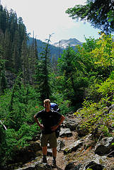 Sean looking chipper on the steep part of the Necklace Valley Trail.  Watering up next to the Michael Nesby Memorial Footbridge. 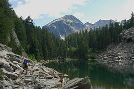 Arriving at Jade Lake. 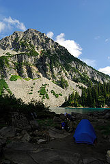 Peninsula camp at Lake Ilswoot.  Ilswoot showing off it's colors.  Dinner.  LaBohn Peak from Ilswoot.  Cool "helicopter" flower. 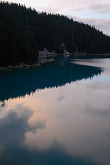 Evening reflections with fish swirls. 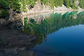 Morning reflection. 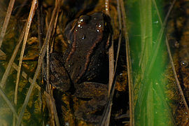 The frogs were shy, I couldn't get any to face me. 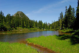 Emerald Lake.  2 labels A view up to LaBohn Gap from the head of the Necklace Valley.  This is a steep trail!  Looking back down to the Necklace Valley from the edge of the LaBohn Lakes shelf.  Cool broken rock in an un-named tarn.  Conquerer of the Gap!  Middle and Lower LaBohn Lakes.  Interesting vein in the rocks.  Lake Rowena with the Citadel above and Mt. Stuart peeking over the Citadel's shoulder.  Chain Lakes, Williams Lake, Dutch Miller Gap, and the Middle Fork Snoqualmie Valley. 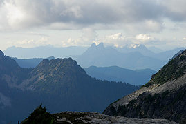 Mt. Baring in the haze. 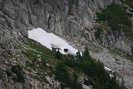 Picture of a snow cave. And what's that black thing?  Why, I do believe that's a bear! Didn't realize it was in the picture at the time or I'd have set the camera on a rock for a clearer shot.  Looking to the South along the ridgeline. It's clouding up rapidly here, but nice and clear to the South and East... 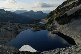 Upper and lower LaBohn lakes, distant peaks. Can't see the middle lake from this angle.  The lighting's starting to get pretty good.  Obligatory tent shot, Summit Chief in the background. 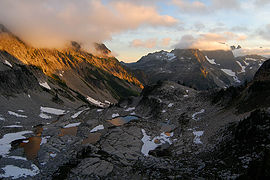 Chain Lakes reflecting cloud colors.  Alpenglow and clouds on Summit Chief, Chimney Rock, & Overcoat Peak. 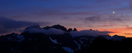 Good night!  Cloudy, cold morning with a low (~6000 ft.) ceiling. 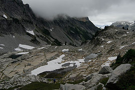 Descending to Chain Lakes. 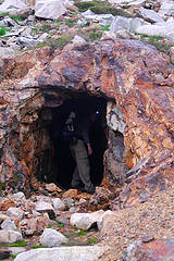 Sean checks out one of the old shafts.  Cool old cable puller thingie. The lever still moves! 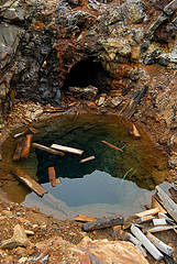 Spooky shaft protected by the bottomless pit. 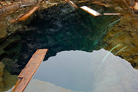 Don't fall in!  Lots of fascinating rocks hereabouts.  Rusty Creek.  Colorful, contaminated sediments.  Lush, mossy creek just a stone's throw away.  We need to be on that shelf. 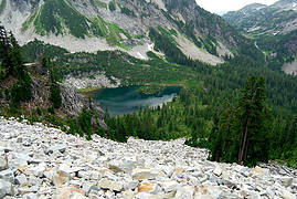 A view down to Williams and the DMG.  Lovely tarn in the land of rock & heather.  That'd make a nice rain shelter.  Well hello there! (Immature Bald Eagle?) Who's been chewing on your tailfeathers?  Salamander in the South Tank Lake.  Mountain Ducks!  Foehn Lake.  Ubiquitous balloon ribbon.  Cool looking tree in the mist.  Camp at Locket Lake. Lots of mosquitoes here!  Morning stillness. Still cloudy but warmer.  So warm and wet, in fact, that my camera lens kept fogging up. - Negotiating the shores of Al Lake. 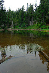 Back at Jade Lake.  The fungus among us.
|
| Back to top |
  
|
|
Magellan
Brutally Handsome

Joined: 26 Jul 2006
Posts: 13116 | TRs | Pics
Location: Inexorable descent |
|
Magellan
Brutally Handsome
|
Thu Sep 11, 2008 11:06 pm |
|
|
Gorgeous! Thanks for the tour Willie. It just raced up high on my list.
|
| Back to top |
|
|
Matt
Tea, Earl Grey, Hot

Joined: 30 Jan 2007
Posts: 4307 | TRs | Pics
Location: Shoreline |
|
Matt
Tea, Earl Grey, Hot
|
Thu Sep 11, 2008 11:07 pm |
|
|
Great variety of lakes, critters, and artifacts in your photos.
I especially like the photo of Chain Lakes at sunset, because I like that group of tarns.
As beacons mountains burned at evening. J.R.R. Tolkien
As beacons mountains burned at evening. J.R.R. Tolkien
|
| Back to top |
|
|
Dayhike Mike
Bad MFKer
Joined: 02 Mar 2003
Posts: 10958 | TRs | Pics
Location: Going to Tukwila |
You got some nice shots!  Thanks for the TR! Thanks for the TR!
"There is only one basic human right, the right to do as you damn well please. And with it comes the only basic human duty, the duty to take the consequences." -P.J. O'Rourke
"Ignorance is natural. Stupidity takes commitment." -Solomon Short
"There is only one basic human right, the right to do as you damn well please. And with it comes the only basic human duty, the duty to take the consequences." -P.J. O'Rourke
"Ignorance is natural. Stupidity takes commitment." -Solomon Short
|
| Back to top |
|
|
Backpacker Joe
Blind Hiker

Joined: 16 Dec 2001
Posts: 23956 | TRs | Pics
Location: Cle Elum |
Good work. Always brings back wonderful memories.
"If destruction be our lot we must ourselves be its author and finisher. As a nation of freemen we must live through all time or die by suicide."
Abraham Lincoln
"If destruction be our lot we must ourselves be its author and finisher. As a nation of freemen we must live through all time or die by suicide."
Abraham Lincoln
|
| Back to top |
|
|
Slide Alder Slayer
Member

Joined: 14 Jan 2002
Posts: 1960 | TRs | Pics
|
|
| Back to top |
|
|
Hiker Mama
Member

Joined: 25 Jun 2006
Posts: 3451 | TRs | Pics
Location: Lynnwood |
What a wonderful set of photos you got yourself there!
|
| Back to top |
|
|
Bedivere
Why Do Witches Burn?
Joined: 25 Jul 2008
Posts: 7464 | TRs | Pics
Location: The Hermitage |
|
Bedivere
Why Do Witches Burn?
|
Fri Sep 12, 2008 9:32 pm |
|
|
Thanks everyone!
Will someone please go up to Foehn Lake, dive down, and retrieve the sunken aluminum can from the bottom of it? It sticks out like a sore thumb when viewed from the SW side. I would have tried to do it if the weather had been hot.
Then, could you please tie a large rock around the neck of whoever threw that in there and toss them back in it's place?
 
|
| Back to top |
|
|
puzzlr
Mid Fork Rocks

Joined: 13 Feb 2007
Posts: 7220 | TRs | Pics
Location: Stuck in the middle |
|
puzzlr
Mid Fork Rocks
|
Sat Sep 13, 2008 1:47 am |
|
|
How hard was getting up to La Bohn gap? I'm thinking about going on a similar route with a less experienced hiker in early October.
|
| Back to top |
|
|
Bedivere
Why Do Witches Burn?
Joined: 25 Jul 2008
Posts: 7464 | TRs | Pics
Location: The Hermitage |
|
Bedivere
Why Do Witches Burn?
|
Sat Sep 13, 2008 1:15 pm |
|
|
| puzzlr wrote: | | How hard was getting up to La Bohn gap? I'm thinking about going on a similar route with a less experienced hiker in early October. |
It's very steep, but not terribly long. The upper portion, above the boulder field requires a veggie-belay in a couple spots, but no big deal, really.
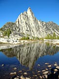
This picture provides the key - Head up into the boulders below the last of the trees on the East side of the valley (left in this pic), between the lowest snow patch and the trees/rocks above. Hug the edge of the tree line all the way up the boulder field until it meets the cliff face above (not visible in this pic). At that point, cut left (North) into the trees, the path is fairly obvious if you look for it, and it's easy enough to follow after that. It's about an 800-900 foot climb from the valley bottom, approximately 500 feet of that is on the boulder field, and very steep in places, but not technically difficult.
|
| Back to top |
|
|
Karen²
A Real Canadian Girl
Joined: 25 Jul 2002
Posts: 1367 | TRs | Pics
Location: Behind the Lens |
|
Karen²
A Real Canadian Girl
|
Sat Sep 13, 2008 5:01 pm |
|
|
| Chainsaw_Willie wrote: | | but the weather didn't cooperate for what could have been the most scenic part of the trip.
Still, I took over 400 photos and filled up my 4 gig memory card. |
Well the weather did not stop you from bringing home some fantastic shots! VERY nice.
|
| Back to top |
|
|
puzzlr
Mid Fork Rocks
Joined: 13 Feb 2007
Posts: 7220 | TRs | Pics
Location: Stuck in the middle |
|
puzzlr
Mid Fork Rocks
|
Sat Sep 13, 2008 7:30 pm |
|
|
| Chainsaw_Willie wrote: | |
... At that point, cut left (North) into the trees ... |
So if I'm reading you right, the obvious gap in the photo is NOT LaBohn Gap, which is out of site above and to the left in the picture, right?
|
| Back to top |
|
|
Bedivere
Why Do Witches Burn?
Joined: 25 Jul 2008
Posts: 7464 | TRs | Pics
Location: The Hermitage |
|
Bedivere
Why Do Witches Burn?
|
Sat Sep 13, 2008 9:43 pm |
|
|
No, that's the gap alright, but the route up to it is off to the left, as I described. The route actually takes you to the outlet of lower La Bohn lake, which is a little lower than the gap itself. I suppose you could go directly up to the obvious low spot but you are presented with two unsavory factors: 1 - lots more boulders to hop, and hopping them the entire way to a higher point, and 2- a very steep permanent snow field right at the top which you can't get around without scaling cliffs. This late in the year it looks more doable, especially if you have crampons and an ice-axe, but earlier in the year the face of that snow field is nearly vertical. Even now it's quite steep. Going via the trail route requires no extra equipment, plus it's far more scenic. The gap itself is nothing special, just a low spot in a big ridge. It's the area around the gap that's cool.
|
| Back to top |
|
|
RichP
Member

Joined: 13 Jul 2006
Posts: 5634 | TRs | Pics
Location: here |
|
RichP
Member
|
Mon Sep 15, 2008 4:42 pm |
|
|
| puzzlr wrote: | | Chainsaw_Willie wrote: | |
... At that point, cut left (North) into the trees ... |
So if I'm reading you right, the obvious gap in the photo is NOT LaBohn Gap, which is out of site above and to the left in the picture, right? |
Puzzlr, I went directly up to the Gap via the boulders on Friday of last week. My partner was not very experienced on such terrain and felt quite nervous. There is a moat that has formed, so you don't have to ascend the snow, which is steep and hard. Though we made it fine, I'm glad we didn't have to descend the same route. I couldn't say which route is easier since I've only done this one. I saw two others going up the waterfall route at the same time.
|
| Back to top |
|
|
DIYSteve
seeking hygge

Joined: 06 Mar 2007
Posts: 12655 | TRs | Pics
Location: here now |
|
DIYSteve
seeking hygge
|
Mon Sep 15, 2008 5:47 pm |
|
|
| RichP wrote: | | I couldn't say which route is easier since I've only done this one. I saw two others going up the waterfall route at the same time. |
The climber's tread/route to the left, near the outfall, is easier than the direct route in mid-season (steep snow) conditions. I have not done the direct route this late in the season, but I recall it being a bit steep up there.
|
| Back to top |
|
|
|
|


