| Previous :: Next Topic |
| Author |
Message |
Schmidt Altitude
Whippet Entourage


Joined: 28 Mar 2007
Posts: 803 | TRs | Pics
Location: The Quah |
Dates: Saturday, November 1st
Crew: Yana, dicey, yukon222, Schmidt Altitude (Babe, Row, Kief, Dude)
Summit: Web Mountain (a.k.a. Middle Defiance), 5335
Hiking Stats: ~4150' feet gained, ~8 miles round trip, 6 hours 22 minutes
References: diceys 2007 trip report, gabrielx's trip report at yellowleaf.org
Note: Some trip reports on this and other sites have incorrectly referred to Web Mountain as West Defiance Peak. West Defiance is actually Point 4926, located .42 miles SE of Mailbox Peak, also known as Dirtybox since it lies between Mailbox and Dirty Harry's Peaks.
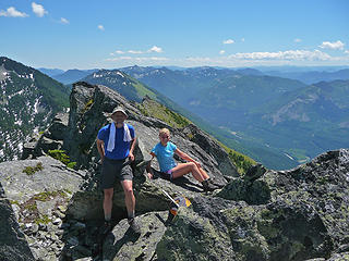
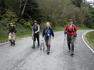 Paved roads are extreme! 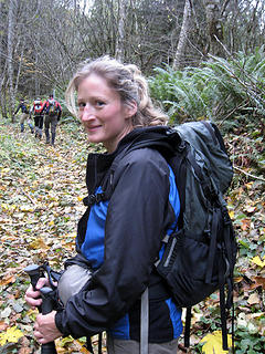 The hair is still curly from last night's costume 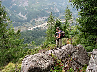 Dude savors the I-90 views 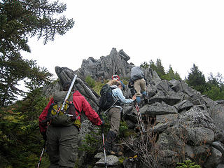 Climbing by the interesting rock formations 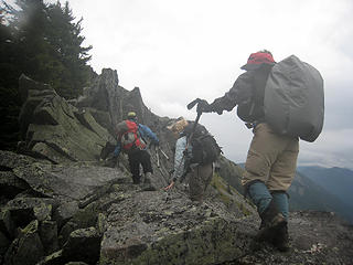 Carefull, the wet rocks are slick! 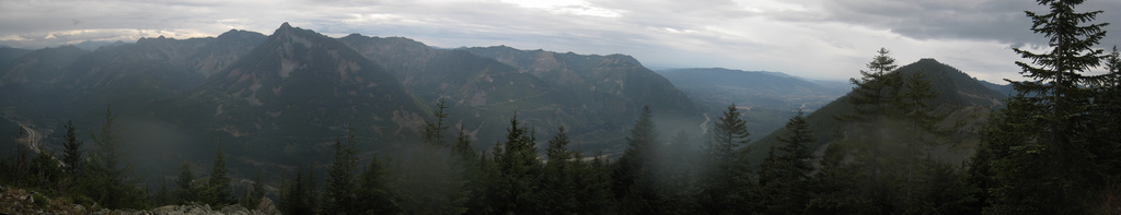 4 labels View south from the windy, rainy ridge 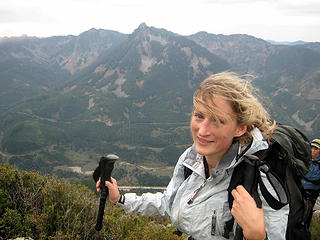 A wind whipped Babe and McClellan Butte 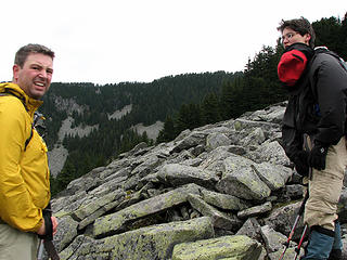 We could do without this wind, though 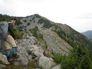 Yana with the summit in the distance (Putrid Pete's Peak off to right) 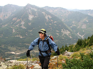 Dicey and McClellan Butte 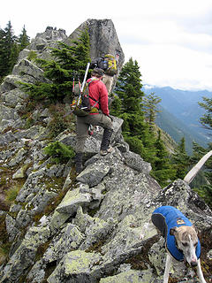 Getting around/over these rocks was the hardest part of the climb 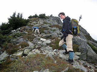 Yana and Kiefer are almost there 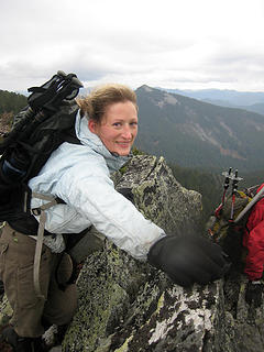 Babe touches the top 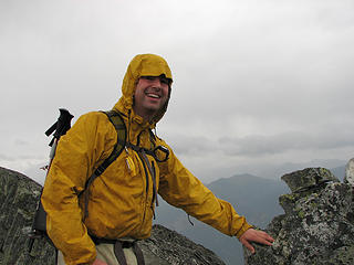 This weather finally had Dude wearing some clothes 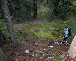 In the forest and out of the wind 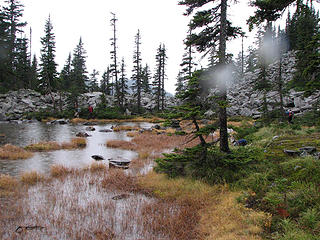 Dirty-Web Tarn
"Forest 101: These big wood stick things are called trees. The big rocks are called mountains, and the little rocks are their babies." Elliott from Open Season
"Forest 101: These big wood stick things are called trees. The big rocks are called mountains, and the little rocks are their babies." Elliott from Open Season
|
| Back to top |
  
|
|
yukon222
Member

Joined: 12 Mar 2007
Posts: 1893 | TRs | Pics
|
|
yukon222
Member
|
 Tue Nov 04, 2008 12:46 pm |
|
|
It is official. Hiking in November now so all thoughts of warm dry hikes have vanished from my head. Expected plenty of wind on the high 5000'+ ridgeline. Fortunately, most of the rain waited to pelt us until after we arrived at the small summit area. Very nice bonus to see a bald eagle soar by 75yds away, working the wind currents effortlessly.
The rocks on the ridgeline are mostly Class 2, perhaps a few brief spots of low Class 3. The rock is slick though, even when mostly dry. And with the slabs tilting out/down, had to be cautious in a few spots. Even with the rain and high winds, a fun way to explore more of the high ridges outside of North Bend.
|
| Back to top |
|
|
GeoTom
Member

Joined: 19 May 2005
Posts: 3215 | TRs | Pics
Location: Earth |
|
GeoTom
Member
|
Tue Nov 04, 2008 12:48 pm |
|
|
| Schmidt Altitude wrote: | This weather finally had Dude wearing some clothes |
I hope Old Blue* is under that yellow jacket.
*Not sure if you have given that shirt a name yet, so I gave it one.
|
| Back to top |
|
|
Go Jo
of the lykkens

Joined: 08 Jun 2003
Posts: 2248 | TRs | Pics
Location: Around The Bend |
|
Go Jo
of the lykkens
|
Tue Nov 04, 2008 1:36 pm |
|
|
| Schmidt Altitude wrote: | The climber path climbs steeply up (isnt that the definition of a climbers path) until it gains the west ridge leading to the summit. |
I assume the words "gradual elevation gain" do not appear in the Schmidt & Co dictionary  Glad to hear that the rain held off until you had gained the summit ~Jo
|
| Back to top |
|
|
meandmyaussies
Member

Joined: 01 Nov 2007
Posts: 182 | TRs | Pics
Location: The Quah |
Looks like a fun trip - glad you got out on a more or less crappy day. Been there via PPP but it's on my list to get there from the west more or less in the way you guys did it. I was up on Squak Mtn Saturday also trying to squeek one in before the weather hit. On the way back I had just been thinking to myself that the winds felt strong enough to bring down a tree when one fell right across the trail about 50 feet or so in front of me and the pups.
Good job with the pics - it's hard to get good shots when the wind is blowing so hard.
p.s. I don't think there is a summit register up there but there is a geocache in the east crease of the summit block. The register for Web seems to be on PPP but that's another story entirely... 
|
| Back to top |
|
|
E's Mom
Member

Joined: 12 Aug 2006
Posts: 297 | TRs | Pics
Location: Southwest Washington |
|
E's Mom
Member
|
Tue Nov 04, 2008 8:32 pm |
|
|
I am continuously impressed with those Whippets! I don't know much about the breed, but are they unusually agile dogs? Personally, I would be scared to take our dog (an English Setter) on some of those rocks I see your Whippets scrambling up. Maybe I just worry excessively and dogs are actually better suited for climbing than their adult companions?
"I will lift my eyes to the hills. From whence does my help come? My help comes from the Lord, who made heaven and earth."
Psalm 121:1
"I will lift my eyes to the hills. From whence does my help come? My help comes from the Lord, who made heaven and earth."
Psalm 121:1
|
| Back to top |
|
|
wamtngal
Member

Joined: 13 Jun 2004
Posts: 2382 | TRs | Pics
Location: somewhere |
|
wamtngal
Member
|
Tue Nov 04, 2008 8:43 pm |
|
|
| GeoTom wrote: | | Schmidt Altitude wrote: | This weather finally had Dude wearing some clothes |
I hope Old Blue* is under that yellow jacket.
*Not sure if you have given that shirt a name yet, so I gave it one. |
 If that shirt ever disappears from Dude's wardrobe, I'm not sure what people would do. Chaos would ensue, I'd bet. Old Blue, I like it. If that shirt ever disappears from Dude's wardrobe, I'm not sure what people would do. Chaos would ensue, I'd bet. Old Blue, I like it.
Opinions expressed here are my own.
Opinions expressed here are my own.
|
| Back to top |
|
|
Schmidt Alti-Dude
4th class poster
Joined: 06 Jul 2007
Posts: 1361 | TRs | Pics
Location: Looking for Adventure 201! |
| E's Mom wrote: | | I am continuously impressed with those Whippets! I don't know much about the breed, but are they unusually agile dogs? Personally, I would be scared to take our dog (an English Setter) on some of those rocks I see your Whippets scrambling up. Maybe I just worry excessively and dogs are actually better suited for climbing than their adult companions? |
Whippets are certainly one of the best "athletes" of the dog world. Fast and agile plus their smaller size (30lbs) give them an advantage over heavier dogs. Babe worries about them too but as I always say, they have 4WD and we don't. They do have to be encouraged on exposed sections of the route and they don't do well in cold weather, though.
Anything stated by me in no way reflects the attitudes or opinions of my wife
Anything stated by me in no way reflects the attitudes or opinions of my wife
|
| Back to top |
|
|
Jasper
Cascade Snow Pig

Joined: 13 Apr 2008
Posts: 350 | TRs | Pics
Location: Burrowing in the snow |
|
Jasper
Cascade Snow Pig
|
Tue Nov 04, 2008 9:37 pm |
|
|
Hey! I'm pretty agile too. Border collies consistently win the agility competitions.  Of course, I am a bit heftier than the whippets (I'm not fat, I'm stout) and my dad isn't strong enough to lift me up like Alti-Dude can to Row and Kief. Maybe he needs to work out more. My extra bulk also helps me in cold weather.
|
| Back to top |
|
|
gone
Member
Joined: 08 Feb 2008
Posts: 1051 | TRs | Pics
|
|
gone
Member
|
Tue Nov 04, 2008 10:49 pm |
|
|
Welcome back to the neighborhood! So that's how you get up Web Mountain!  Too many rocks (and wind, apparently), so thanks for sharing the pics and saving me the trip!
|
| Back to top |
|
|
EastKing
Surfing and Hiking

Joined: 28 Mar 2007
Posts: 2082 | TRs | Pics
Location: 77 miles from Seattle! |
|
EastKing
Surfing and Hiking
|
Tue Nov 04, 2008 10:58 pm |
|
|
Awesome trip and photos!
YouTube | SummitPost
Saw the depths of despair. Now I am salvaging what time I have left on Earth.
YouTube | SummitPost
Saw the depths of despair. Now I am salvaging what time I have left on Earth.
|
| Back to top |
|
|
puzzlr
Mid Fork Rocks

Joined: 13 Feb 2007
Posts: 7220 | TRs | Pics
Location: Stuck in the middle |
|
puzzlr
Mid Fork Rocks
|
Tue Nov 04, 2008 11:12 pm |
|
|
Last summer my daughter and I climbed up via the tarn route and tried to come down the ridge. We diverted back to the tarn route on the way down when it started getting hard to get around the rocks (my daughter is not as excited about off-trail scrambling as I am). I think your direction is better and this winter I'll give the ridge another try, but on the way up.
 Summit shot looking E toward Snoqualmie Pass
|
| Back to top |
|
|
Middle E
no more moustache

Joined: 10 Feb 2008
Posts: 432 | TRs | Pics
Location: Seattle, WA |
|
Middle E
no more moustache
|
Wed Nov 05, 2008 10:27 am |
|
|
| Schmidt Altitude wrote: | | We didnt find a register but then again, we werent looking too hard in those conditions. |
There was a register there last summer - inside an ammo can tucked down in the big rocks. Far fewer names than the one at Putrid Pete's! I came over from Pete's (having come up via DH Balcony and Connector trails) and then went down the ridge you came up. That was a fun descent... 
pithy yet insightful signature
pithy yet insightful signature
|
| Back to top |
|
|
|
|


