| Previous :: Next Topic |
| Author |
Message |
Matt
Tea, Earl Grey, Hot


Joined: 30 Jan 2007
Posts: 4307 | TRs | Pics
Location: Shoreline |
|
Matt
Tea, Earl Grey, Hot
|
 Mon Dec 08, 2008 2:00 am |
|
|
Dates: November 29-30, 2008
Destination: Mt. Daniel
Party: Dicey, Yana, Heather M, Gabriel D, Matt
Whod have thought you could drive to the Cathedral Rock trailhead at the end of November?
But there was less than a foot of snow on the road, and barely a few feet of snow all the way up on the highest parts of Daniel.
Snowpack for the trip was much more like late spring than early winter - varying from minor slush to deep enough for snowshoes. The snowshoes went on or off at least eight times between trailhead and summit.
Clouds both obscured and enhanced the view hiding the peaks from below, but highlighting the dark summits between bands of bright white up high. Overhead, gray drizzle turned to clear blue and then back again, timed just right to match our summit visit.
Lakes slowly conceded to the winter cold the big lakes still mostly open water, but the smaller tarns reduced to shrinking patches of ice amid the encroaching snow. In between, the transition crafted complex swirls of ice and snow across the waters surfaces.
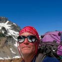
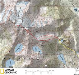 Daniel Trip Map 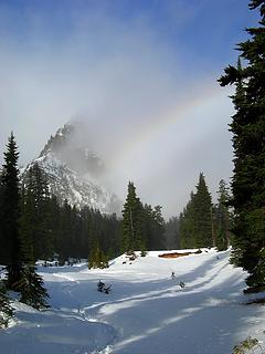 Cathedral Rock throwing a rainbow 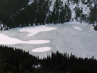 Deep Lake Snowy 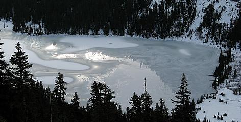 Deep Lake Shiny 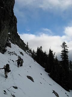 Crossing below Cathedral Rock 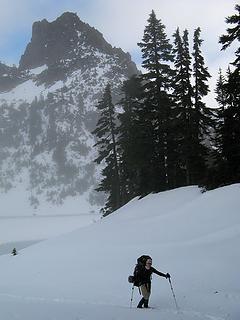 Arriving at Peggys Pond 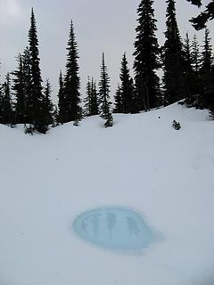 Blue Tarn near camp 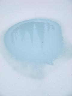 Blue Tarn Close-up 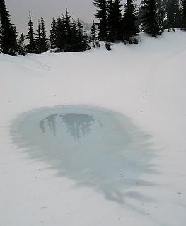 Gray Tarn near camp 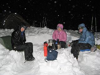 Dinner 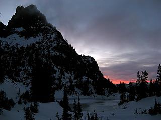 Departing Peggys Pond at sunrise 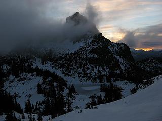 Higher up 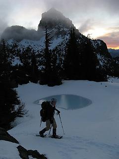 Passing a tarn on the SE ridge 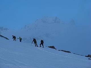 East Daniel materializing from the mist 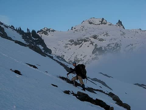 East Daniel above the clouds 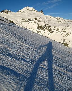 Long legs help the ascent 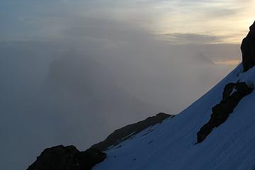 Cathedral & Stuart Hiding 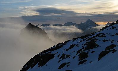 Ready or Not 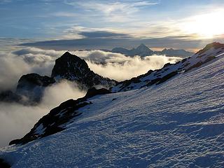 Here We Come 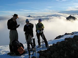 Tag, Youre It 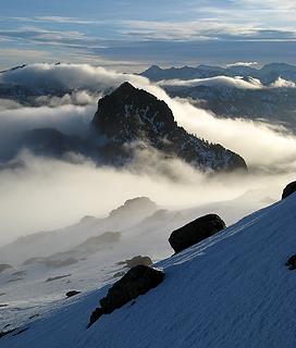 Cathedral amid layers of cloud and fog 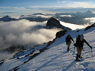 Hiking above it all 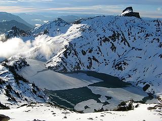 Circle Lake 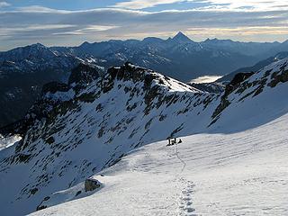 Putting snowshoes back on in Daniels east basin 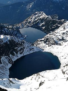 Venus & Spade 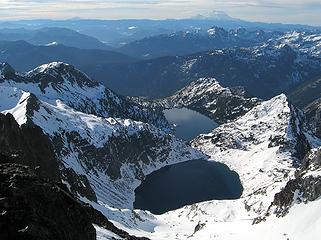 Venus & Spade, Adams & Rainier 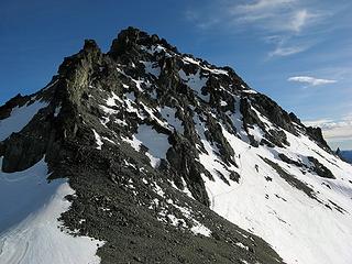 Traversing off of East Daniel 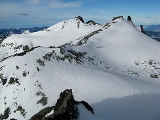 Easy terrain to Middle & West Daniel 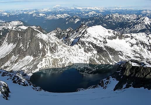 Pea Soup Lake & Glacier Peak 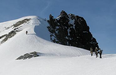 Approaching Daniels Summit 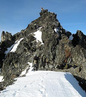 Short scramble on West Daniel 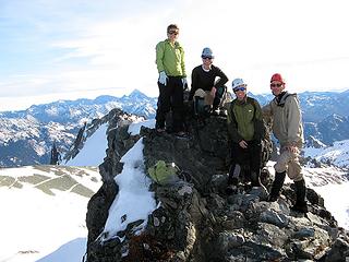 Heather, Yana, Dicey, & Gabriel at the summit 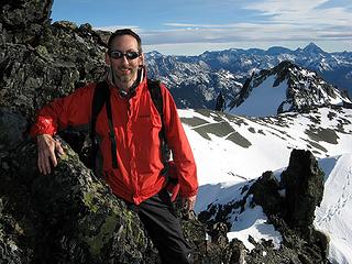 Matt at the summit 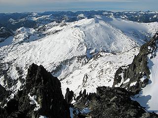 Hinman from West Daniel 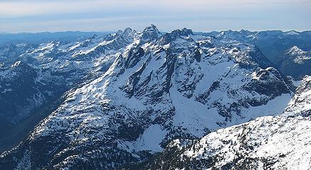 Snoqualmie Crest Bears Breast, Summit Chief, Chimney Rock, Lemah, Chikamin 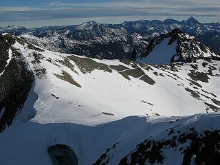 Returning past Middle Daniel (look for three dots on the snow and rocks) 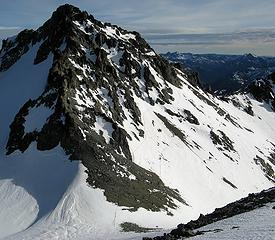 Traversing past East Daniel (upper track incoming, lower track outgoing) 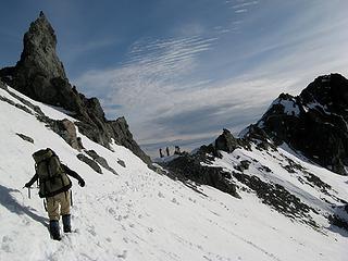 The col north of Point 7662 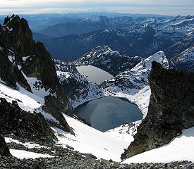 Venus & Spade in brighter sunlight 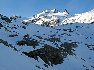 Looking back to East Daniel from a lower step in the bowl 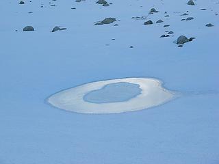 Shiny little tarn in the lower bowl 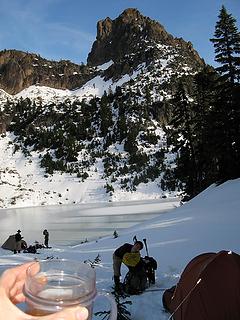 Iced tea at camp while Yana is consumed by her pack 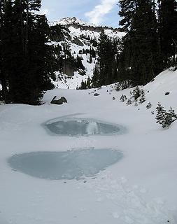 Tracks across tarns below Peggys Pond 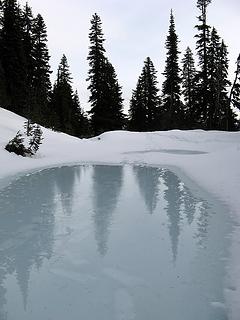 See the snowshoe tracks on the ice? 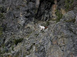 Goat watching our progress past Cathedral Rock 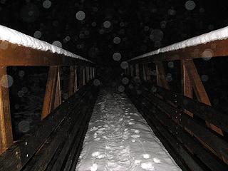 Drizzle returning at the bridge across Cle Elum River  Daniel being polite two days earlier at Thanksgiving 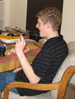 Daniel being rude two days earlier at Thanksgiving  Daniel
As beacons mountains burned at evening. J.R.R. Tolkien
As beacons mountains burned at evening. J.R.R. Tolkien
|
| Back to top |
  
|
|
Schmidt Altitude
Whippet Entourage

Joined: 28 Mar 2007
Posts: 803 | TRs | Pics
Location: The Quah |
Another entertaining read with great photos Matt. Especially liked "Hiking Above It All"
"Forest 101: These big wood stick things are called trees. The big rocks are called mountains, and the little rocks are their babies." Elliott from Open Season
"Forest 101: These big wood stick things are called trees. The big rocks are called mountains, and the little rocks are their babies." Elliott from Open Season
|
| Back to top |
|
|
Go Jo
of the lykkens

Joined: 08 Jun 2003
Posts: 2248 | TRs | Pics
Location: Around The Bend |
|
Go Jo
of the lykkens
|
Mon Dec 08, 2008 3:14 am |
|
|
| Matt wrote: | Departing Peggys Pond at sunrise |
It's always a wonderful feeling to poke your head out of the tent and find clearing skies and a beautiful sunrise. Glad the views opened up in time for your summit traverse.
|
| Back to top |
|
|
DIYSteve
seeking hygge

Joined: 06 Mar 2007
Posts: 12655 | TRs | Pics
Location: here now |
|
DIYSteve
seeking hygge
|
Mon Dec 08, 2008 8:27 am |
|
|
Thanks. Great pics. Daniel in late November! 
|
| Back to top |
|
|
peltoms
Member

Joined: 13 Jul 2006
Posts: 1760 | TRs | Pics
Location: Worcester MA |
|
peltoms
Member
|
Mon Dec 08, 2008 8:37 am |
|
|
A trip to Daniels in December, unreal without snowshoes and stopping due to leg ache much lower. Daniel looks older than 13, looks ready for Mount Daniels in better conditions.
|
| Back to top |
|
|
wamtngal
Member

Joined: 13 Jun 2004
Posts: 2382 | TRs | Pics
Location: somewhere |
|
wamtngal
Member
|
Mon Dec 08, 2008 9:30 am |
|
|
I've been looking forward to this trip report and it did not disappoint! Mmmmm, eye candy! Nice work all!
Opinions expressed here are my own.
Opinions expressed here are my own.
|
| Back to top |
|
|
Slide Alder Slayer
Member

Joined: 14 Jan 2002
Posts: 1960 | TRs | Pics
|
Outstanding trip and pictures!!!
|
| Back to top |
|
|
adamcwatts
Member
Joined: 27 Jun 2008
Posts: 66 | TRs | Pics
Location: Redmond |
I always wanted to see a trip report of Danielle in December and now I have. It looks like snow shoes are a must for the climb although I would think that crampons would be used more, am I wrong?
|
| Back to top |
|
|
Matt
Tea, Earl Grey, Hot
Joined: 30 Jan 2007
Posts: 4307 | TRs | Pics
Location: Shoreline |
|
Matt
Tea, Earl Grey, Hot
|
Mon Dec 08, 2008 2:49 pm |
|
|
I'd always bring both snowshoes and crampons in winter. Which one you need depends on conditions. This year there was exceptionally little snow, and we could mostly boot up, more like spring conditions. Usually, early in the winter like this, you'd have unconsolidated snow and have to use snowshoes. I've also known people who went the whole way on crampons later in winter on top of a hard crust.
Also, if there were normal snow depths, avalanche danger would require careful evaluation.
As beacons mountains burned at evening. J.R.R. Tolkien
As beacons mountains burned at evening. J.R.R. Tolkien
|
| Back to top |
|
|
adamcwatts
Member
Joined: 27 Jun 2008
Posts: 66 | TRs | Pics
Location: Redmond |
Makes sense Matt, thanks for explaining 
|
| Back to top |
|
|
BirdDog
Member
Joined: 09 Jan 2007
Posts: 1067 | TRs | Pics
Location: Seattle |
|
BirdDog
Member
|
Mon Dec 08, 2008 4:23 pm |
|
|
Way to go folks, nice!
"There can be no greater issue than that of conservation in this country."
Teddy Roosevelt August 6, 1912
"There can be no greater issue than that of conservation in this country."
Teddy Roosevelt August 6, 1912
|
| Back to top |
|
|
run4cache
Member

Joined: 18 Jun 2006
Posts: 137 | TRs | Pics
|
I'm jealous. What a GREAT trip!
|
| Back to top |
|
|
touron
Member
Joined: 15 Sep 2003
Posts: 10293 | TRs | Pics
Location: Plymouth Rock |
|
touron
Member
|
Mon Dec 08, 2008 6:38 pm |
|
|
Touron is a nougat of Arabic origin made with almonds and honey or sugar, without which it would just not be Christmas in Spain.
|
| Back to top |
|
|
Tazz
Member
Joined: 27 Apr 2005
Posts: 7902 | TRs | Pics
|
|
Tazz
Member
|
Mon Dec 08, 2008 6:59 pm |
|
|
sheesh Matt you need to get a bit faster on your trs...I have been WAITING for this one!!!!! frothing at the mouth...  good stuff folks...great images!! I love that climb.
|
| Back to top |
|
|
Curtissimo
Member

Joined: 05 Sep 2007
Posts: 295 | TRs | Pics
Location: Mexico Lindo y Querido si Muero Lejos de Ti |
great report!
if it's any consolation, my sister was a total b!$(& at Thansgiving and almost ruined it for all of us. At least you can still spank your son! My sister is too old for that now!
|
| Back to top |
|
|
|
|
You cannot post new topics in this forum
You cannot reply to topics in this forum
You cannot edit your posts in this forum
You cannot delete your posts in this forum
You cannot vote in polls in this forum
|
Disclosure: As an Amazon Associate NWHikers.net earns from qualifying purchases when you use our link(s). |


