| Previous :: Next Topic |
| Author |
Message |
loper
Member


Joined: 11 Aug 2007
Posts: 453 | TRs | Pics
Location: seeking the sun |
|
loper
Member
|
 Tue Jan 27, 2009 9:12 pm |
|
|
Here is our route up Sauk from Saturday. Roughly 5,000 gain and 6 miles? roundtrip. Crampons and ice axe required.
Going up the southeast ridge made for a long day but never a dull moment. It starts off steep with lots of brush and blowdowns. About two and a half thousand feet of steep bushwhacking 'fun'. Just when you start thinking you can't take any more 'fun' it starts opening up for some nice views. It gets better and better as the ridge becomes more defined. Then the final summmit block. At this point we were past our turn-around time and one pair of crampons short. To make a short story long I opted to become the team photographer while Bill and John quickly topped out on the lookout summit and returned. I settled in to take the summit shot, eat lunch and drink tea when wait! where did they go?...what?.......now they are on the next bump!.....NOW where are they?! They made it up to the true summit!!! Way to go!!! Sometimes the best summits are the ones you don't think will happen.
A long hike down in the dark which I thought just couldn't get any more 'fun' but it did when we found ourselves above the road cliffed out about a hundred feet up. Luckily Bill had found a 'trail' which was a trail in only the most rudimentary sense of the word but none the less we were very thankful for and we made it down to the road. We were tired, full of pine needles and a few branches but satisfied with our day in the mountains. AND we found out there is a Red Robin in Burlington that is open till eleven on Saturday night!! I think we were there by nine or so but good to know for future reference. Burgers, Fries, Beer (and hot chocolate with schnapps for me). A great way to finish up the day.
Lisa
PS these photos were taken by John, Bill and the ones of the final summit push by me. Thanks John and Bill for letting me post your pictures
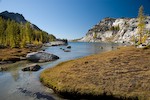
 Sauk-Bald  IMG_3713_nearing-the-top IMG_3717_B-continuing-to-summit approaching lookout summit steep! steep closeup we aren't holding hands it will only take 10 more minutes true summit sunlight with sleeve 'Jesus' beams IMG_3748_meeting-of-Sauk&Skagit-rivers IMG_3752_L's-headlamp-back-on-road
|
| Back to top |
  
|
|
Type E
Member

Joined: 19 Aug 2006
Posts: 1381 | TRs | Pics
|
|
Type E
Member
|
Tue Jan 27, 2009 9:19 pm |
|
|
|
| Back to top |
|
|
GeoTom
Member

Joined: 19 May 2005
Posts: 3215 | TRs | Pics
Location: Earth |
|
GeoTom
Member
|
Tue Jan 27, 2009 9:24 pm |
|
|
Nice Lisa.  And John and Bill too.
|
| Back to top |
|
|
EastKing
Surfing and Hiking

Joined: 28 Mar 2007
Posts: 2082 | TRs | Pics
Location: 77 miles from Seattle! |
|
EastKing
Surfing and Hiking
|
Tue Jan 27, 2009 9:33 pm |
|
|
YouTube | SummitPost
Saw the depths of despair. Now I am salvaging what time I have left on Earth.
|
| Back to top |
|
|
gone
Member
Joined: 08 Feb 2008
Posts: 1051 | TRs | Pics
|
|
gone
Member
|
Tue Jan 27, 2009 10:08 pm |
|
|
Very cool! We don't often get long distance perspective shots like those here, as the hiker/photographers are usually on top, too - very unique!
|
| Back to top |
|
|
Matt
Tea, Earl Grey, Hot

Joined: 30 Jan 2007
Posts: 4307 | TRs | Pics
Location: Shoreline |
|
Matt
Tea, Earl Grey, Hot
|
Tue Jan 27, 2009 10:36 pm |
|
|
Like others said, cool shots of the hikers going up.
Really nice of you to support the others going up.
I notice on your map that one of the many Bald Mountains is next door to Sauk. We climbed a different Bald on the same day.
As beacons mountains burned at evening. J.R.R. Tolkien
As beacons mountains burned at evening. J.R.R. Tolkien
|
| Back to top |
|
|
puzzlr
Mid Fork Rocks

Joined: 13 Feb 2007
Posts: 7220 | TRs | Pics
Location: Stuck in the middle |
|
puzzlr
Mid Fork Rocks
|
Tue Jan 27, 2009 11:09 pm |
|
|
Was the bushwhacking bad because of lack of snow, bad snow, thick forest, or something else?
|
| Back to top |
|
|
Magellan
Brutally Handsome

Joined: 26 Jul 2006
Posts: 13116 | TRs | Pics
Location: Inexorable descent |
|
Magellan
Brutally Handsome
|
Tue Jan 27, 2009 11:11 pm |
|
|
 Nice work y'all. Nice work y'all.
|
| Back to top |
|
|
loper
Member
Joined: 11 Aug 2007
Posts: 453 | TRs | Pics
Location: seeking the sun |
|
loper
Member
|
Wed Jan 28, 2009 10:46 am |
|
|
| puzzlr wrote: | | Was the bushwhacking bad because of lack of snow, bad snow, thick forest, or something else? |
Sorry, should have been more specific.
Parked at milepost 99 next to the river. (lots of eagles on the river right now). Compass heading of 320 degrees.
Start 350 ft
Summit 5541 ft
Consistent snow level roughly around 3,000ft? all of it rock hard.
The bushwhacking was due to lack of snow with lots of blowdowns, lots of just dead branches etc. Once we were up on the ridge it opened up and the views were great, travel just like a ridge walk should be. Was a fun trip but not an easy one. Will have to go back and summit some day.
Lisa
|
| Back to top |
|
|
Quest for Adrenaline
Member
Joined: 10 May 2008
Posts: 119 | TRs | Pics
Location: Bellingham, WA |
aside from the avi danger it looks like a good winter ascent you just gave me an idea and i like the pics very nice.
|
| Back to top |
|
|
Layback
Cascades Expatriate
Joined: 16 Mar 2007
Posts: 5712 | TRs | Pics
Location: Back East |
|
Layback
Cascades Expatriate
|
Sat Jan 31, 2009 9:50 pm |
|
|
Nice. Sauk is a fun scramble.
|
| Back to top |
|
|
Mossman
Member
Joined: 07 Nov 2005
Posts: 6 | TRs | Pics
Location: Seattle, WA |
|
Mossman
Member
|
Mon Feb 02, 2009 11:31 pm |
|
|
There is an old trail to the top of Sauk from hwy 20... once a fully constructed forest service quality. I am not sure how much it gets used, but it was followable ~5 years ago with only minor blowdown.
You can find it by looking at the older 15" usgs maps (i.e. in topo software). It is easiest to spot right where the 2nd growth turns to old growth about 4-500' above the valley floor near Barr Creek. There are two ways to get to it - either follow an old log road with a beaten path, just west of conrad road, or just start west of Barr Creek on conrad road and go up the hill to intersect it (faint track, some brush).
|
| Back to top |
|
|
TrailPair
Member

Joined: 17 Apr 2005
Posts: 1699 | TRs | Pics
|
Lisa, Gorgeous photos. Looks like some potential for next years NW Calendar. 
This thing called work is interfering with my play
This thing called work is interfering with my play
|
| Back to top |
|
|
peltoms
Member

Joined: 13 Jul 2006
Posts: 1760 | TRs | Pics
Location: Worcester MA |
|
peltoms
Member
|
Tue Feb 03, 2009 3:29 pm |
|
|
Great shot of sauk and skagit confluence
|
| Back to top |
|
|
loper
Member
Joined: 11 Aug 2007
Posts: 453 | TRs | Pics
Location: seeking the sun |
|
loper
Member
|
Thu Feb 05, 2009 4:57 pm |
|
|
| TrailPair wrote: | | Lisa, Gorgeous photos. Looks like some potential for next years NW Calendar. |
I wish!! That calendar is awesome! I am always amazed at the calibar of the photos posted here on nwhikers. Makes me a little embarressed to post my own but am learning by example, at least a little!
And Mossman, thanks for the info, I will be heading back that way some day again.
L
|
| Back to top |
|
|
|
|


