| Previous :: Next Topic |
| Author |
Message |
Matt
Tea, Earl Grey, Hot


Joined: 30 Jan 2007
Posts: 4307 | TRs | Pics
Location: Shoreline |
|
Matt
Tea, Earl Grey, Hot
|
 Wed Jan 28, 2009 2:48 am |
|
|
Date: 1/24/09
Destination: Bald Mountain (Silverton) 4795
Party: Matt, mtnmike, rdyhiker, BarbE, Lori J, Lynn G, Richard B
The snow condition was: Crusty. Crusty trench along the road. Crusty untracked snow in the valley. Crusty frozen avalanche debris on all the slopes. Crusty old cornices on the ridge. Crusty arête on top. Nasty slippery lumpy foot-tripping crust on the way down.
Route:
Theres a whole passel o Bald Mountains out there. This is the one near Silverton, off the Deer Creek Road, north of Long Mtn, south of Kelcema Lake.
Our route was: Hike the Deer Creek Road 3.5 miles from the MLH (1575 ft) to the hairpin bend (2834 feet). Go SW up the valley toward the Long-Bald col, and ascend through the gap in the lower band of cliffy slabs. Then angle NW to go right of cliffy slabs until you can angle over and get onto the south ridge of Bald. Circa 4550, theres a 10-foot rock step downward on the ridge. Then follow the ridge to the summit.
This route on Bald works best with lots of snow, as long as avalanche danger is low, and preferably without the nasty crust. Its a longer road walk, but the winter snow covers the alder in the valley and the slabs higher up. Its a snow scramble except for the rock step; more about that later.
 Bald Mtn South Ridge Route Map 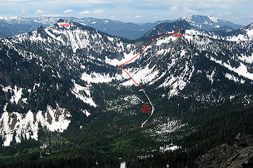 Bald Mtn Route (viewed from Devils Peak 5/31/08) 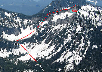 Closeup of Route 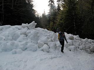 First avalanche across the road 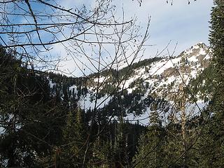 Bald Mtn from the Long-Bald col to the summit 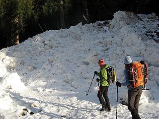 Second avalanche across the road 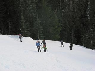 Coming out of trees onto avy debris above the lower cliff band 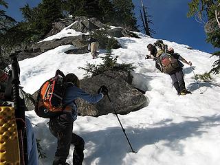 A line of ascent that didnt work out 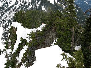 Rdyhiker & BarbE waiting by the rock step. 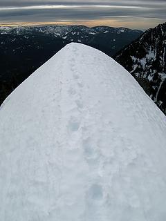 Summit arête, vertical 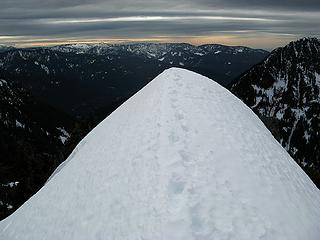 Summit arête, horizontal 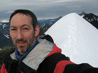 Self-portrait 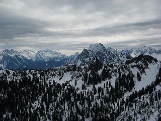 Big Four (above the ridge of Long) 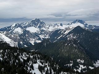 Three Fingers & Whitehorse 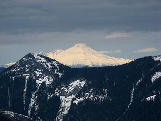 Baker (above Jumbo) 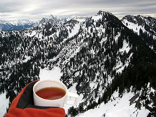 Summit tea looking back down to the Bald-Long col and basin 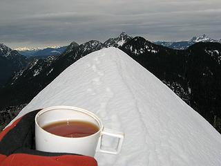 Summit arête looking toward Helena 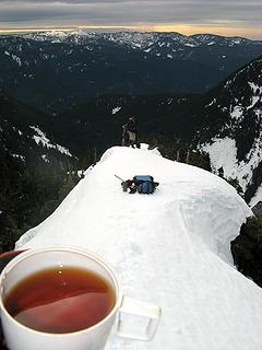 The rest of the party coming up the crest 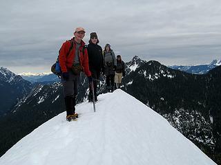 Mike, Lori, Lynn & Richard on the summit (no choice about standing single file) 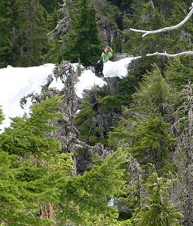 BarbE photographing me photographing her from near the summit 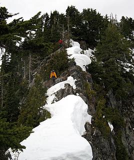 Coming back down the ridge to the step 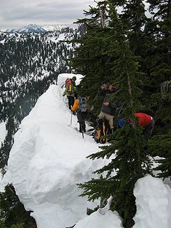 Heading back down the ridge 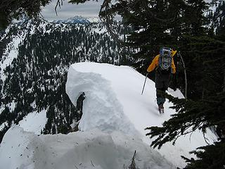 Hook-beaked cornice 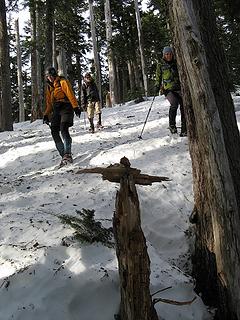 One of Mikes wooden cairns among the trees 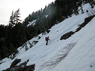 Crossing a steeper spot 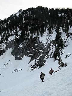 Descending debris into the basin 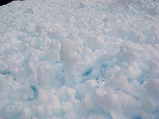 Melt patterns in the debris 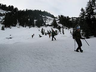 Our route had gone up the snowy slabs in center, then left by the trees on the crest.
As beacons mountains burned at evening. J.R.R. Tolkien
As beacons mountains burned at evening. J.R.R. Tolkien
|
| Back to top |
  
|
|
Hiker Mama
Member

Joined: 25 Jun 2006
Posts: 3451 | TRs | Pics
Location: Lynnwood |
Wow, Matt and company. Your TRs are always fascinating to me.
I'm sending get-well wishes to everyone.
|
| Back to top |
|
|
tigermn
Member

Joined: 10 Jul 2007
Posts: 9242 | TRs | Pics
Location: There... |
|
tigermn
Member
|
Wed Jan 28, 2009 9:13 am |
|
|
Wow definitely out of my comfort zone (I'll stick to walking to Kelcema Lake), but always enjoy reading such reports.
|
| Back to top |
|
|
wildernessed
viewbagger

Joined: 31 Oct 2004
Posts: 9275 | TRs | Pics
Location: Wenatchee |
 Nice Arete shots Matt, hope everyone heals quickly. Nice Arete shots Matt, hope everyone heals quickly.
Living in the Anthropocene
Living in the Anthropocene
|
| Back to top |
|
|
wamtngal
Member

Joined: 13 Jun 2004
Posts: 2382 | TRs | Pics
Location: somewhere |
|
wamtngal
Member
|
Wed Jan 28, 2009 9:55 am |
|
|
Looks like a fun trip! Sorry to hear about the slippages and injuries - heal quickly folks!
Opinions expressed here are my own.
Opinions expressed here are my own.
|
| Back to top |
|
|
loper
Member

Joined: 11 Aug 2007
Posts: 453 | TRs | Pics
Location: seeking the sun |
|
loper
Member
|
Wed Jan 28, 2009 10:24 am |
|
|
Nice work although sorry to hear about the injuries.
Take care,
L
|
| Back to top |
|
|
the Zachster
Member

Joined: 17 Jan 2007
Posts: 4776 | TRs | Pics
Location: dog training |
Clearly the value of a trip has more to do with the quality of your companions than the quality of the snow/conditions! What a bummer with all of those injuries. I hope they heal real quick so you can all get out enjoy better conditons soon. Let it snow...let it snow...let it snow!
"May I always be the kind of person my dog thinks I am"
"May I always be the kind of person my dog thinks I am"
|
| Back to top |
|
|
dicey
custom title

Joined: 11 May 2004
Posts: 2870 | TRs | Pics
Location: giving cornices a wider berth |
|
dicey
custom title
|
Wed Jan 28, 2009 10:42 am |
|
|
Thanks for the report Matt. Maybe soon we can trade out wearing crampons all day to wearing snowshoes or skis?
Sorry to hear about the injuries on your trip - that is a real drag.
From your pics/map it looks like one could do Long and Bald via the connecting ridge. Maybe a good early spring trip with stable snow conditions and longer days?
|
| Back to top |
|
|
gone
Member
Joined: 08 Feb 2008
Posts: 1051 | TRs | Pics
|
|
gone
Member
|
Wed Jan 28, 2009 11:29 am |
|
|
Interesting report, if a bit unnerving. Lots of work, for sure, but some great views.
Some unfortunate injuries. Sure sounds like rdyhiker got the worst of it. Rib injuries are terrible things.  Thanks for sharing the details, and I hope everyone heals quickly!
|
| Back to top |
|
|
BarbE
Member

Joined: 28 Jul 2006
Posts: 1153 | TRs | Pics
|
|
BarbE
Member
|
Wed Jan 28, 2009 12:58 pm |
|
|
Intense, exciting, a bit unnerving at times, but a good memorable trip as far as I'm concerned.
Experienced company and no falls, aches or pains helped make this a fun adventure for me.
Good conversations made the long road walk go fast and as a bonus the weather ended up being better than anticipated. Good thing too with the challenging terrain ahead of us.
Thanks Matt for lending me your crampons and giving expert advice.
It made all the difference on the steep crusty ascent and greatly improved my confidence.
Not making it to the very top wasn't a disappointment at all, although in hindsight it looked quite doable.
Gotta go-Rdyhiker and I are off to check out crampons this afternoon.
A few more pics
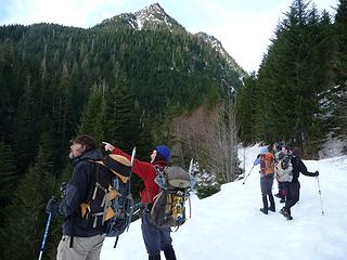 Mike pointing out peaks 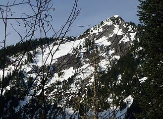 Bald Mountain looking bald 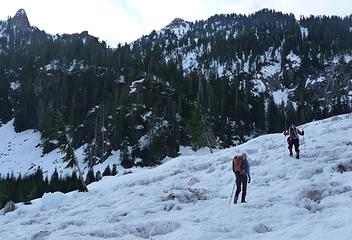 Crossing the lower avalanche debris 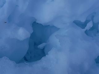 Rock hard ice formations 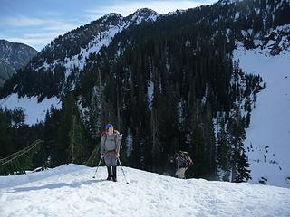 Mike getting to a flat spot 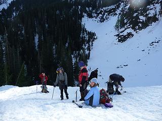 First lunch spot 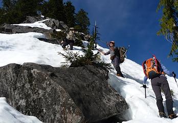 Finding a safer route 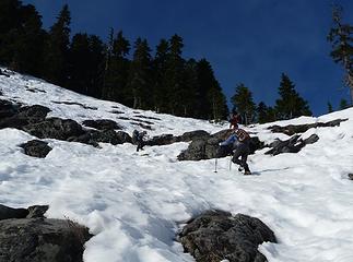 Soft snow on the way up 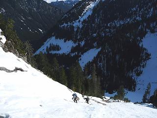 A long ways up 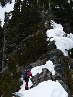 Matt heading up the narrow ridge 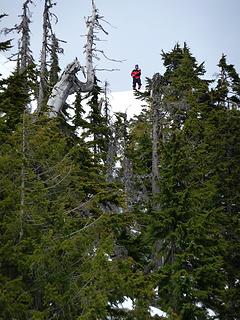 Matt near the summit 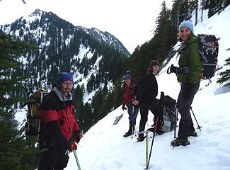 Dang- that's steep  Rdyhiker's careful descent
|
| Back to top |
|
|
Go Jo
of the lykkens

Joined: 08 Jun 2003
Posts: 2248 | TRs | Pics
Location: Around The Bend |
|
Go Jo
of the lykkens
|
Wed Jan 28, 2009 1:35 pm |
|
|
My stomach did flip flops just looking at some of the pictures. Looks to be a true adventure! If rdyhiker and barbe are off to look at crampons of their very own the challenge of it must have out weighed the injuries. Great report & photos ~Jo
|
| Back to top |
|
|
Joey
verrry senior member

Joined: 05 Jun 2005
Posts: 2797 | TRs | Pics
Location: Redmond |
|
Joey
verrry senior member
|
Wed Jan 28, 2009 4:52 pm |
|
|
Summit tea - nice touch - I like it.
The pics and TR are good too.
|
| Back to top |
|
|
Schmidt Alti-Babe
The Ice Queen
Joined: 11 Mar 2008
Posts: 606 | TRs | Pics
Location: Buried by backlogged pictures |
| Matt wrote: | | You can tell how Im feeling about a route by what happens with my equipment. If Im concerned about traction on the snow, I get out my ice axe. If Im concerned about traction on rock, I take my gloves off. And if Im concerned about finding a workable line for the route overall, I stop taking pictures. On this trip, my ice axe came out below the first cliff band. My gloves came off for the rock step. And I have no pictures from the time we left the road until we reached the ridge, except for two times that we stopped in the upper basin. |
Even though I enjoyed all of your TR, this part really stuck with me.
Conditions sounded a bit intense. And all that avalanche debris. Wow.
Heal up quickly everyone. 
|
| Back to top |
|
|
puzzlr
Mid Fork Rocks

Joined: 13 Feb 2007
Posts: 7220 | TRs | Pics
Location: Stuck in the middle |
|
puzzlr
Mid Fork Rocks
|
Wed Jan 28, 2009 8:44 pm |
|
|
Nice report. I always feel like I'm getting the real story with your reports. No sandbagging!
Do you know if the way you got in there would be a feasible route to Long Mountain? I've seen routes from the other side, but it looks very steep.
|
| Back to top |
|
|
Tazz
Member
Joined: 27 Apr 2005
Posts: 7902 | TRs | Pics
|
|
Tazz
Member
|
Wed Jan 28, 2009 8:45 pm |
|
|
good stuff matt and all!
|
| Back to top |
|
|
|
|
You cannot post new topics in this forum
You cannot reply to topics in this forum
You cannot edit your posts in this forum
You cannot delete your posts in this forum
You cannot vote in polls in this forum
|
Disclosure: As an Amazon Associate NWHikers.net earns from qualifying purchases when you use our link(s). |


