| Previous :: Next Topic |
| Author |
Message |
Stefan
Member


Joined: 17 Dec 2001
Posts: 5091 | TRs | Pics
|
|
Stefan
Member
|
 Tue May 29, 2007 1:51 pm |
|
|
Bear Mountain 5/26/2007
Plans changed for me at the last minute for Memorial Day weekend so I was scrambling for something to do. It turned out Greg K., had nothing planned on Saturday and with my change of plans I was free for Saturday. What to do that we both have not done? Bear Mountain.
Bear is one of the more difficult one day ascent peaks and is rarely visited, but we did it. In fact, I found it more difficult than Red (Sultan). We ended up doing the NE ridge which I do believe is a first ascent. The Beckey book is not very descriptive on the North Ridge by Ken Carpenter and friends so I am not sure if they went the way we did. We saw no evidence of a previous ascent/descent.
We left Jacks Pass at 7:30a.m. and walked the abandoned road around to around 2800 feet. At the corner of this extremely alder choked road you can ascend a scree slope up to a stump and get a pretty good view of Bear Mountain. My goal was to do the NE ridgeline because it looked treed and nicer than the east face. So we descended to around 2200 feet from this road corner, crossed San Juan Creek, and then started traversing to the north. We traversed across two creeks, the second one was more important to noteit was somewhat dry and the key ridgeline to go up. Once across at 2800 feet we went up pretty good forest sometimes.
I believe around 3100 feet we traversed slightly north around the base of some cliffs, only to regain the forested ridgeline again. We then came across a small 12 foot class 4 section directly on the ridge, and then back again to some more forested ridgeline. I believe around 3400 feet is when roped climbing began. The ridgeline then turned into class 4/low class 5 with some brush and trees to contend with. The first climbing pitch ends at a pretty descent belay directly on the ridge. The second climbing pitch will end in a steep forest about 15 feet north of the true ridgeline. After the second and final climbing pitch there is some steep forest to ascend, one last scrambling section in steep duff, and then wala, you are at a forested flat bench at 3800 feet. This is where we hit snow.
From 3800 feet you then walk up a gradual uphill section, and then open land, only to reenter the forest. We moved slightly more to the direct north slope at 4200 feet because the angle was lessthere was also a decent creek in here
but it was mostly snow covered. Soon the forest gave way at 4600 feet and we had open slopes. We ascended to around the 4900 feet area and then did a traverse across steep snow to the base of the summit northeast face. We did rope up for the traverse starting at 4900 feetwhich was snow covered--and the traverse started below rock walls and downsloping slabby rock.
The NE face directly below the summit was steep with the snow on it, but we did it roped up with intermittent protection from a picket and slings around minor trees.
We summitted at 4:00 and left at 4:10. No register.
We did two rappels from almost near the summit to where we could downclimb the snow, and then walk across the traverse. The NE ridgeline required us to complete 3 rappels on the return. We did not want to go back up to the alder choked road which left directly from Jacks Pass, so we chose the LONG way back. We went down to the abandoned road at around 1600 feet on the south side of the North Fork of the Skykomish. But to get there requires the person to walk through TERRIBLE former clear cut area jack strawed trees/brush from 2300 feet and down. The abandoned road back to the bridge across the North Fork of the Skykomish is definitely better than the alder choked road from above, but it still has plenty of brush
just definitely not as bad. We got to the bridge across the North Fork of the Skykomish at 9:45 and a big family campout
.we were hoping they would take the bait and drive us to Jacks Pass (a 2 mile walk)
but they did not offer. So we walked the road to Jacks Pass and back to the car at 10:40
..
Just over 15 hours but we really were not that tired because it was only around almost 4000 feet of gain total for the entire day with waits for belaying and rappelling.
If you do the NE ridge here are my recommendations:
1) drive to Garland Mineral Springs and see if you can cross the river at a braid. We could see a shack at Garland Springs and it looked optimal to access San Juan Creek.
2) Be prepared for bushwacking in the 8-9 range from 1800 feet (where the abandoned road recrosses San Juan creek) to around 2300 feet where the clearcut stops
3) Bring a 60 meter rope. Pro not needed on NE ridgeline due to plenty of trees, just slings. Not sure on pro needed for directly below summit because we had snow.
4) Mid May seems to be a more optimal time to do this route with the traverse. Late May may be too late
but not sure about the traverse
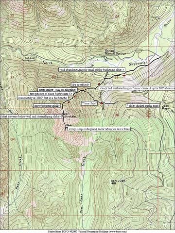 Bear mountain route
|
| Back to top |
  
|
|
wildernessed
viewbagger

Joined: 31 Oct 2004
Posts: 9275 | TRs | Pics
Location: Wenatchee |
 Beautiful looking mountain. I remember in Jan. doing Frog Mountain. Then PaulK and JeffR were reconning that peak. Beautiful looking mountain. I remember in Jan. doing Frog Mountain. Then PaulK and JeffR were reconning that peak.
Living in the Anthropocene
Living in the Anthropocene
|
| Back to top |
|
|
Matt
Tea, Earl Grey, Hot

Joined: 30 Jan 2007
Posts: 4307 | TRs | Pics
Location: Shoreline |
|
Matt
Tea, Earl Grey, Hot
|
Tue May 29, 2007 11:08 pm |
|
|
So you finally got Bear. Thanks for all the detailed route info.
As beacons mountains burned at evening. J.R.R. Tolkien
As beacons mountains burned at evening. J.R.R. Tolkien
|
| Back to top |
|
|
lopper
off-route

Joined: 22 Jan 2002
Posts: 845 | TRs | Pics
|
|
lopper
off-route
|
Wed May 30, 2007 2:29 pm |
|
|
"alder-choked sucky road" from your map.
Here it is about 24 years ago
|
| Back to top |
|
|
Stefan
Member
Joined: 17 Dec 2001
Posts: 5091 | TRs | Pics
|
|
Stefan
Member
|
Wed May 30, 2007 2:41 pm |
|
|
oi! that would have been nice!
|
| Back to top |
|
|
Beave
Member

Joined: 21 Dec 2001
Posts: 276 | TRs | Pics
Location: Woodinville |
|
Beave
Member
|
Wed May 30, 2007 9:23 pm |
|
|
Glad you were able to get this one Stefan, thanks for the beta.
Nice pic Lopper!
|
| Back to top |
|
|
Magellan
Brutally Handsome

Joined: 26 Jul 2006
Posts: 13116 | TRs | Pics
Location: Inexorable descent |
|
Magellan
Brutally Handsome
|
Mon Mar 23, 2009 10:49 pm |
|
|
Thanks Stefan. Your write up has convinced me not to go!
|
| Back to top |
|
|
puzzlr
Mid Fork Rocks

Joined: 13 Feb 2007
Posts: 7220 | TRs | Pics
Location: Stuck in the middle |
|
puzzlr
Mid Fork Rocks
|
Tue Mar 24, 2009 12:54 am |
|
|
[Edit] Just noticed the date - 2 years ago, but I'm glad this got bumped so I could read it.
Wow! Enjoyed reading your TR very much, and it's going into my "when I'm feeling ambitious" file. I've wondered about going up this peak ever since my first trip over Jacks Pass last year when I took this picture.
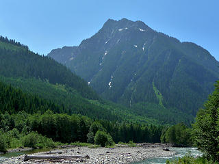 Bear Mountain
|
| Back to top |
|
|
Redwic
Unlisted Free Agent

Joined: 23 Feb 2009
Posts: 3292 | TRs | Pics
Location: Going to the Prom(inence) |
|
Redwic
Unlisted Free Agent
|
Tue Mar 24, 2009 5:51 am |
|
|
| Magellan wrote: | | Thanks Stefan. Your write up has convinced me not to go! |
Really? It's not like it's Teneriffe, Magellan. 
60 pounds lighter but not 60 points brighter.
60 pounds lighter but not 60 points brighter.
|
| Back to top |
|
|
|
|


